Copyright © Panorama Group 1991 - 2024

In KB "Panorama" the version 14.5.6 has been developed. The program implemented filling out the document according to the requirements of the order of the Ministry of building and housing and communal services of the Russian Federation dated 06/03/2022 № 446/pr "On approval of the form of a building permit and permission to put the facility into operation". The document is formed for objects of capital construction according to the information stored in the database.
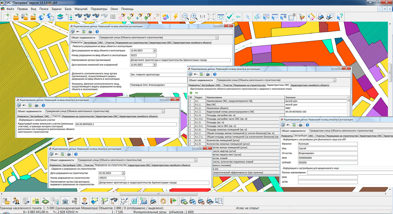
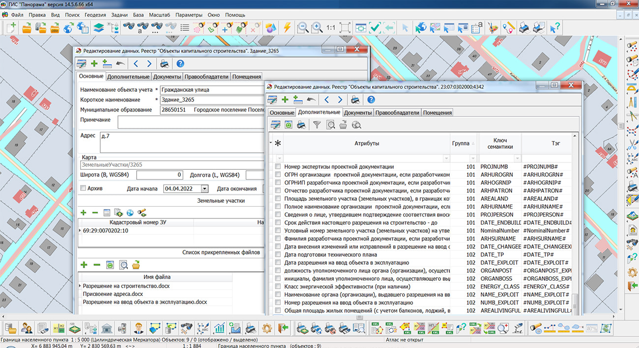
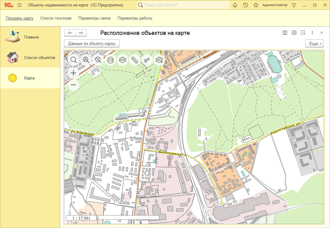
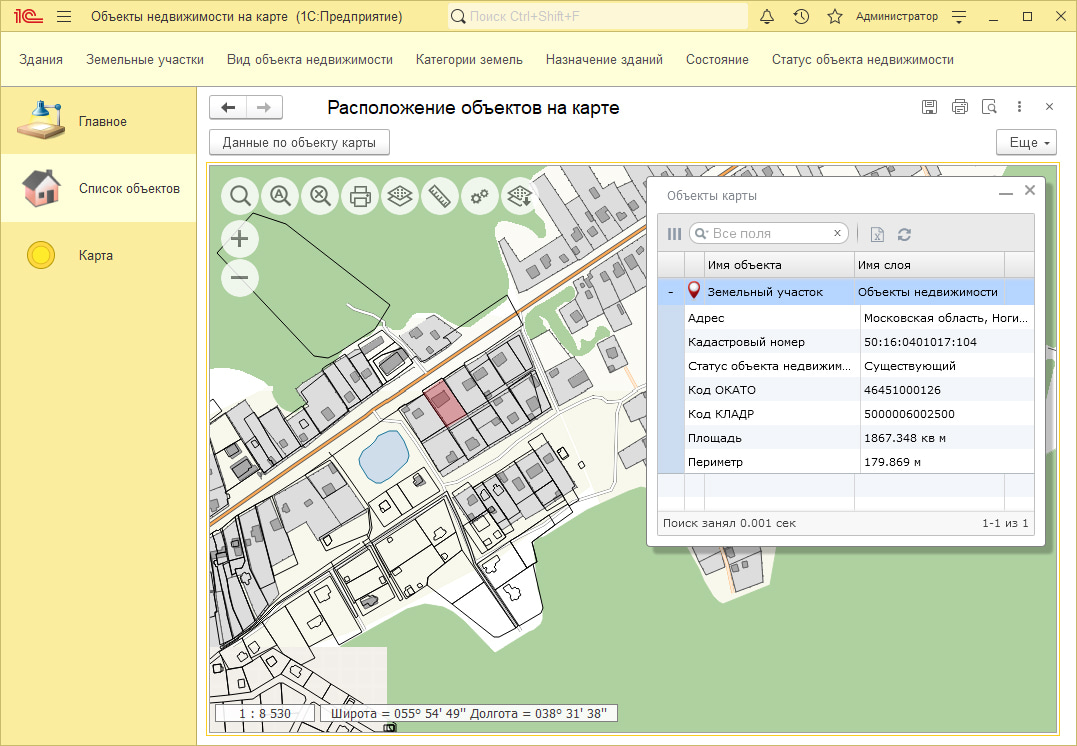
The new form of permission to put an object into operation includes 7 sections: details of the permission to put an object into operation, information about the developer, information about the capital construction object, information about the land plot, information about the building permit on the basis of which the construction was carried out, reconstruction of capital construction object, actual indicators of the capital construction object and information about the technical plan, actual indicators of the linear object and information about the technical plan. For a new form of permission to put an object into operation, additional attributes for capital construction objects have been added to the urban planning database, the attributive information of the permission to put an object into operation has been loaded into electronic map objects.
To generate a permission to put an object into operation, you must specify the object of real estate and fill in the document attributes located on the tabs of the form. Attribute information of the document is filled in the new dialog "Permission to put the object into operation", which is called from the register of accounting objects or by clicking the "Reports formation" button located on the main panel of the Complex. The dialog tabs correspond to the sections of the new form of the document. Many attributes are filled in automatically in accordance with the building permit, on the basis of which the construction (reconstruction) of the capital construction object was carried out. After filling in the attributive information, you can generate a document in the office suite. Completely blank sections of the form are not included into the document.
The form of the document is formed on the basis of prepared templates of the dot format. Templates contain a descriptive part and named markers that tell the program where to insert data. Procedure of document formation is customizable. The user can change a template according to various regional and departmental requirements. There is a relationship between the attributes of the permission to put the object into operation and the markers in the template, which is customized in the directory "List of attributes for type of accounting object". To exchange data with an electronic map in the same directory, each attribute can be assigned any semantic characteristic of the object according to the survey classifier.
Saving of the created document "Permission to put object into operation" in urban-planning database has been implemented.
The generated permission to put the object into operation can be saved on disk in doc, docx, pdf formats. If necessary, an electronic copy of the document is loaded into the file storage of the database of the Complex. In this case, the document file is attached to the list of files of the capital construction object.
By means of the "Update of semantics on the map" mode, it is possible to load the attributive information of permission to put the object into operation into the electronic map's object. A necessary condition for updating semantics is the existence of a connection between a record in the database and an object on the map. The update procedure can work both with one or several records, and with the entire list of capital construction objects.
The new version of the program is available for download in the section.


In KB "Panorama" the has been developed. In the new version the tools have been added for calculations by semantics of objects, controlling of display and search of various categories of terrain objects, import and export of data, the tools of the task "Classifier Editor" have been expanded, the list of geoportals is added, the tasks of "Check of vector map quality" and "Correction of objects metrics" are improved, in the block of geodetic and cadastral tasks the mode "Formation of map-plan of the territory" has been implemented, the modes "Base of cadastral works", "Technical plan", and others have been updated.
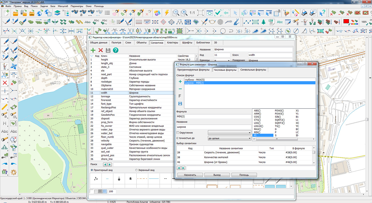
The list of operations for semantics of the "Numerical formula" type and for the mode in the Map Editor task has been expanded. Operation "SUM" has been added to sum the values of the object's repeatable semantics. For example, if semantics with the code "345" are numeric and repeatable (an object can have several semantics with the code "345" with different values) and you need to get the sum of all values, then the expression should be "SUM(#345)" in the formula. For semantics of the "Symbol formulas" type and for the mode in the Map Editor task, support for repeatable semantics has been added. The values of the repeated semantics are written to the resulting string separated by commas.
The task has been improved. On the tab, a hierarchy of classes in the form of a multilevel tree has been added in the object tree of the classifier. For the selected class, the ability to enable/disable the visibility of objects, to select objects on the map are available. For objects that are part of the tree, but not on the map, the color of the visibility state icons has been updated - "gray". On the "Maps" tab, the "Enable/Disable graphic objects" mode has been added, which allows you to set graphical objects in the selection conditions.
To increase the security of data hosted on the , a ban on editing the map passport has been added if the user does not have data administration rights or if the ban on displaying coordinate system parameters on the client is enabled.
has been improved. Support of multilines and multipolygons has been added. The map was unloaded by means of visibility scales limitation, taking into account the "Levels" and "EndLevel" tags. When the map is increased, the image contains a small terrain area of highly detailed. When the map is decreased, a large area with less detail. This method of the map sparseness allows you to increase the readability of the map and speed up the display of the map. Importing a map from the polish format is done through the menu: File - Import navigation from ... - GPS/Polish format (MP).
A new script has been added into the Tools - Run Applications menu in the Import/Export Data group to automate saving the images of vector maps located in a selected folder in TIF format.
Module "Geodesy editor" has been improved. In dialog the possibility has been added for interruption of process of stream processing of selected objects when inserting data into several files. There is added a formatting of strings inserted into Excel with leading and trailing spaces. A space at the beginning of elements the "name of a piece", "length of a piece", "DeltaX", "DeltaY" is inserted for elimination of Excel autoformatting. Otherwise, it performs date substitutions for records like "5-4" in "Apr 5", for "3.12" in "Dec 3", and others.
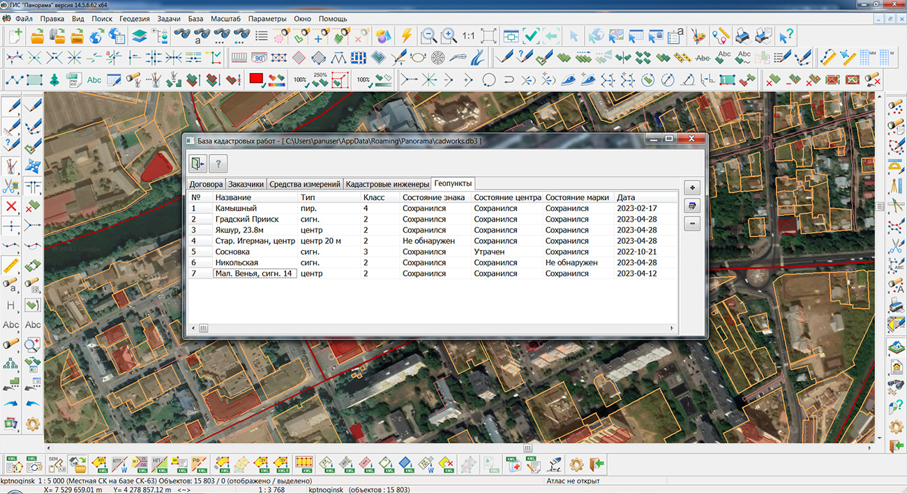
The module "Cadastral documents" has been improved. A new mode has been developed, intended for the formation of an XML-document provided to the Unified State Register of Real Estate in the course of complex cadastral work. The form of the document, the procedure for filling and submitting it, the requirements for the format in electronic form are approved by order of the Federal Register of March 16, 2017 N P/115. The initial information for the formation of a map-plan of the territory is taken from the digital cadastral map and the database of cadastral works. To prepare a cadastral map containing the necessary objects, the survey.v6 digital classifier was refined. The information necessary to form an electronic XML document is displayed in the dialog elements for viewing and editing. The information of the general sections of the map-plan of the territory is stored in the tables of the cadastral database of the SQLite format and is linked to the cadastral map object that limits the territory of cadastral work. When the program is restarted, the entered values are automatically read and displayed in the dialog elements. Information of cadastral objects is stored in the semantics of cadastral objects - land plots and real estate objects located within the territory of complex cadastral works. The border of territory of complex cadastral works can correspond to one or several cadastral quarters.
The dialog "Base of cadastral works" has been improved, the maintenance of information about the points of the geodetic base used in the preparation of cadastral documents has been added. The mode has been improved. Formation of electronic XML document of the certificate of inspection by XML scheme InspectionAct_v03.xsd has been implemented. The mode supports the creation of XML files for the new and old scheme. The dialog "Data input for the document" has been improved, the list of document details has been expanded. The mode has been improved, processing of several initial XML files in a streaming mode has been accelerated and automatic updating the image of an updated map was executed. For mapping conditional cadastral objects that do not have a spatial component, the analysis of information about the CsID coordinate system is disabled, since such information is not available.
In the "Technical plan" dialog, the order of inserting "Floor plan (parts of the floor)" graphic files into Word has been corrected. In dialog , the formation of AppliedFilePDF element for the "Document on the category of land" and for the "Document on permitted use" has been corrected. Into the task "Cadastral documents" into the mode "Formation of forest declaration" the button "Formation of the text report" based on .DOCX templates has been added. The form of the forest declaration, the procedure for filling and submitting it, the requirements for the format of the forest declaration in electronic form were approved by order of the Ministry of Natural Resources and Ecology of the Russian Federation dated April 29, 2021 N 303. The forest declaration reflects the following information: about the person who filed the forest declaration; on a lease agreement for a forest plot or other document in accordance with which the use of forests is carried out; about the location of the forest area; on the volume of forest use; on the types of use of forests. Input of information for filling the form of the forest declaration is performed by selecting values from a directory and from semantic characteristics of selected objects. Reference information is stored in SQLite database tables.
The task of connecting geoportals has been improved. The geoportal of the Krasnodar Territory, containing the layers: Administrative territorial division, Contours of fields of agricultural land, Fishing grounds, Vine plantations, has been added to the list of geoportals.
The task has been improved. For the obsolete view of objects with "Mixed" type, the ability to select the parameters of a conventional symbol of the "Vector symbol" view has been added. The view of objects "Mixed" is obsolete and cannot be edited, but it can be supplemented with the "Vector symbol" parameters or completely replaced by it. When updating classifiers, it is recommended to recode the titles of characteristics from the type "Mixed" onto "Vector". For editing semantics of the "Numeric formula" or "Symbol formula" type, the following modes have been updated: adding a formula to the list of classifier formulas, deleting a formula from the list if it is not assigned to semantics, editing existing formulas. The "List of formulas" of the library has been added to the "Libraries" tab. For each type of object described in the library, a list of semantics on which this type depends is added. On the "Objects" tab, a new mode "Copying mark object" has been added, which allows you to create a new object by copying all its properties, but changing the code, symbolic code, key. The "Creating new object" mode has been changed. A new object is created based on the first object available for selection with a new, automatically generated name, code, key and alias.
has been improved. Correctness of execution of checking a direction of digitization of areal objects depends on correctness of signs of an external/internal contour.
If the Digitization direction is set for the object as "Object on the right", then the outer contour is digitized clockwise, the inner one - counterclockwise. If the digitization direction is set for the object as "Object on the left", then the outer contour is digitized counterclockwise, the inner one - clockwise. A simple area object must have one outer contour and may have one or more inner contours. A multipolygon must have one or more outer contours and may have one or more inner contours. In both cases, the first contour of the object must be outer. The order of the contours is checked when the "Control of self-crossings and location of subjects" mode is executed. It is more efficient to control and correct the direction of digitization after checking the location of subobjects. Therefore, the check of the digitization direction has been moved from the "Metrics" group to the "Control of self-crossings and location of subjects", which is included into the "Topology" group. At execution of this type of control in the "Edit" mode, a correction of errors location and direction of digitizing the contours is carried out.
The task "Correction of object metrics" has been improved. The algorithm for splitting multi-objects into separate composite objects has been changed. In the "Translation of names" procedure, the ability to process dictionaries in UTF8 encoding has been added.
The new version of the program is available for download on the page.


In KB "Panorama" the toolkit has been developed for creation of GIS-modules for a typical configuration 1C:Enterprise - GIS WebToolKit for 1C. The toolkit consists of expansion for a typical configuration 1C:Enterprise and web application (developed with using the toolkit of developing geoinformation Web-applications the ). An extension for a typical configuration allows 1C developers to add functions for working with spatial data directly into a managed 1C form. Spatial data can be published on various web services: , Yandex, OpenStreetMap, Rosreestr and others. When using the program in an enterprise, you can deploy your own web service and fill it with spatial data from various sources and formats using the .
Using GIS WebToolKit for 1C allows you to display vector, raster (Earth's remote sensing data), matrix maps in a 1C managed form window. The display of spatial data is carried out taking into account the requirements of standard classification systems, coding of map objects and their characteristics in accordance with the requirements of Roskartography, Rosreestr, Topographic Service of the Armed Forces of the Russian Federation and other federal services.
Adding commands for communication with a web application into a typical directory 1C:Enterprise provides a search for a map object for the current record in the 1C directory, search for accounting objects in 1C directories for the selected map object, an obtaining the information about the map object (geometric and semantic characteristics), determining the area, length, perimeter. Spatial data is accessed through an element of the 1C managed form of the "HTML document field" type. A typical 1C configuration should have an interface type - Taxi.
The new version of the program is available for download in the section.


Specialists of KB "Panorama" have prepared and placed the map of the Nizhny Novgorod region on the geoportal . The map was formed using OpenStreetMap data. To work with the map, you can use the program or other software products of KB "Panorama".
The map was led to the modernised classifier of large-scale plans of scale 1: 5 000 (map5000m) and was saved into a packed project (MPTZ). The MPTZ format project includes a digital map of the region's territory (country, subject of the federation, administrative region), a map of the administrative-territorial division of the region and a digital classifier. Publishing of updates in bank of spatial data is made by using the program of . Publishing contents of bank of spatial data on the geoportal and data access for downloading are implemented by means of .
Free maps on the basis of OpenStreetMap data are available for download on the page "Digital maps".


In KB "Panorama" the version 8.3 has been developed. In the new version the tools of control of presence of data in file storehouse have been added. Presence of files for the selected records is checked, a protocol is formed by results. This information can be used for data recovery, analysis and creation of reporting documents. Moving of files from storehouse into archive occurs only when the deletion is approved. Control over the filling of required metadata fields has been added when approving editing operations. When loading analog maps and analog images, control for data duplication has been added.
Tools of search for vector and raster data, analogue maps and images, geodetic materials and documents have been optimised. Search can be carried out at once on several values, their presence or absence. Search by metadata with filter imposing on a map (rectangular area, circle, polygon, map object borders) is supported. All selected data are displayed on a map-scheme and are automatically scaled to obtain a clear picture.
Visualization of displaying geodetic points on a map-scheme has been increased at data clustering. Small objects unite into groups (clusters). Separate maps-schemes of division of nomenclature sheets by scale have been added. Separately for each scale - 1 000 000, 500 000, 200 000, 100 000.
Safety of the data is provided with differentiation of access rights on the basis of the means of safety which are a part of an operating system. Usual check of authenticity, the digest-authentication, system check of authenticity (web server means) and domain (Kerberos or ActiveDirectory) is supported. Additional safety is provided with use of a through authentication at work with a database. Connection to base occurs to the rights of the user working with system. The complex is adapted for work on a wide spectrum of operating systems (Astra Linux SE, ALT Linux, Elbrus, Ubuntu, CentOS, MS Windows and others) and architecture (Intel, Elbrus, Baikal). The program is registered in the register domestic ON at number 1862.
Data security is ensured by the differentiation of access rights based on the security tools that are part of the operating system. Basic authentication, digest authentication, system authentication (web server tools), and domain authentication (Kerberos or ActiveDirectory) are supported. Additional security is provided by the use of pass-through authentication when working with the database. Connection to the database occurs with the rights of the user working with the system. The complex is adapted to work on a wide range of operating systems (Astra Linux SE, ALT Linux, Elbrus, Ubuntu, CentOS, MS Windows and others) and architectures (Intel, Elbrus, Baikal). The program is registered in the register of domestic software under the number 1862.
The databank of digital maps and remote sensing data is the basis for building infrastructure of spatial data of federal, regional and municipal levels, in corporate information systems. Within the framework of a single geoinformation space, the Data Bank of digital maps and remote sensing data realises gathering, storage, quality control, search and delivery of the spatial data in exchange formats. The spatial data selected by means of the program can be placed for the multiuser access on the and be published according to the international standards OGC WFS, WFS-T, WMS, WMTS, WCS on application server the . Users can access data from both a thin client (by means of ) and from desktop applications (, ). The databank of digital maps and remote sensing data provides construction of cloud warehouse of spatial data, provision of access to these data, the automated formation and updating of geocovers.
The current state of spatial data is displayed by means of maps-schemes that are maintained for each type of stored data: vector maps, remote sensing data, elevation matrixes and terrain models. It provides remote placing the sets of spatial data into file warehouse, keeping versions of stored sets, updating maps-schemes of data availability, the automated collection and formation of metadata, and the formation and updating of geocovers. Automated collection and formation of metadata is performed according to the standards of ISO 19115: 2003, Geographic information - Metadata and ISO/TS 19139, Geographic information - Metadata - XML schema implementation. The reduced copies of data images are automatically formed, checksum of files and completeness of data sets are checked. Placement of spatial data into file storage is performed with integrity check, control of data structure and content. The results of the work are recorded and are entered into the metadata base. Automatic backup of metadata and spatial data storage with integrity control and data recovery has been provided. Multilingual interface is supported.
The portal demonstrates the possibilities of organizing storage, accounting and and issuance of vector maps, remote sensing data, matrixes of heights and the terrain models. The portal contains vector maps in SXF format, generated on the basis of data from open sources (OpenStreetMap, VMap0). The spatial data includes maps of: subjects of the Russian Federation, countries and cities of the near and far abroad. In total, over 350 vector maps and 6700 matrix data with a total volume of 80 GB. Specialists of KB "Panorama" weekly update and refresh the content of the information on the portal. All published data is distributed free of charge under a free license.
The new version of the program is available for download on the page.


Ph.: +7 (495) 739-0245, +7 (925) 221-1603
www.gisinfo.ru | panorama@gisinfo.ru
105005, Russia, Moscow, Baumanskaya Street 7, building 1, office 229 (m. Baumanskaya)
Copyright © Panorama Group 1991 - 2024


 Mobile version
 Full version