Copyright © Panorama Group 1991 - 2024

Specialists of KB "Panorama" have prepared and placed the map of the Republic of Mari El on the geoportal . The map was formed using OpenStreetMap data. To work with the map, you can use the program or other software products of KB "Panorama".
The map was led to the modernised classifier of large-scale plans of scale 1: 5 000 (map5000m) and was saved into a packed project (MPTZ). The MPTZ format project includes a digital map of the region's territory (country, subject of the federation, administrative region), a map of the administrative-territorial division of the region and a digital classifier. Publishing of updates in bank of spatial data is made by using the program of . Publishing contents of bank of spatial data on the geoportal and data access for downloading are implemented by means of .
Free maps on the basis of OpenStreetMap data are available for download on the page "Digital maps".


Specialists of KB "Panorama" have prepared a video lesson on using the mode. The considered mode is available to users in the program.
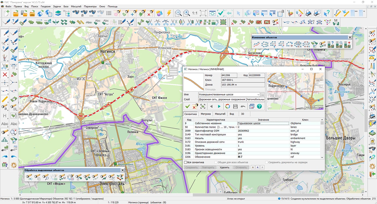
This dialog is used to view information about a single object, consisting of one or more parts. The mode displays the distribution of the numerical values of the characteristics over different parts of the object and its general measuring properties. For example, for a highway, the number of lanes, pavement material, speed limit, slope, and other properties may change. Sections of the road, where the properties are constant, can be digitized by separate objects. Different sections can be logically linked into a single road due to the common property the Road number, Own name or Designation.
You can get acquainted with the training materials in the "Video lessons" section.


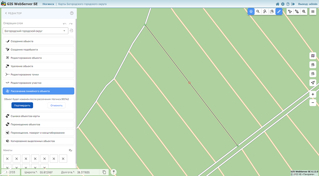
In KB "Panorama" the version 6.12.0 has been developed for operating systems Astra Linux, CentOS, Ubuntu, MS Windows. In the new version, the tools for editing and analyzing the location of map objects have been expanded, measurements on the map and the administration module have been improved.
In the Map Editor new tools of objects geoprocessing - the modes have been added: Copy to another map, Creating a subobjects, Cutting of linear object into several objects. Remote editing of objects allows to receive more exact and updated information in the multiuser mode, and also to create the new data inaccessible before. In regional or corporate portals, the location analysis of objects helps to identify areas of interest or places where urgent action needs to be taken from the map. For example, quickly to display places of rivers floods, to mark areas of roads repairing, communication lines or power grids. The Measurements component has been improved. Now you can create several measurements with saving the results after closing the mode.
GIS WebServer SE is used in the construction of closed corporate systems to ensure the protection of data having a security classification or a trade secret. The program is certified by the 2nd level of control over the absence of undeclared capabilities. GIS WebServer SE is implemented using the , which can be used in development tools that use the JavaScript and TypeScript.
On the basis of GIS WebServer SE and other server products of KB "Panorama" the has been implemented. RGIS RО is a specialized multifunctional geoportal, the interactive capabilities of which provide access to reliable information about objects of various categories. RGIS RO is available to a wide range of users - to the authorities, citizens, organizations, including potential investors and private companies. The regional GIS of the Ryazan region helps in making decisions in various areas of socio-economic development.
New version of the program is posted on the website in the Download section.


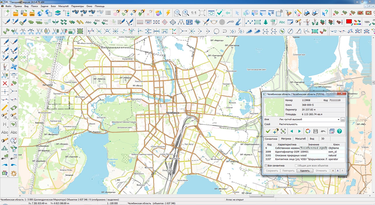
Specialists of KB "Panorama" have prepared and placed the map of the Chelyabinsk region on the geoportal . The map was formed using OpenStreetMap data. To work with the map, you can use the program or other software products of KB "Panorama".
The map was led to the modernised classifier of large-scale plans of scale 1: 5 000 (map5000m) and was saved into a packed project (MPTZ). The MPTZ format project includes a digital map of the region's territory (country, subject of the federation, administrative region), a map of the administrative-territorial division of the region and a digital classifier. Publishing of updates in bank of spatial data is made by using the program of . Publishing contents of bank of spatial data on the geoportal and data access for downloading are implemented by means of .
Free maps on the basis of OpenStreetMap data are available for download on the page "Digital maps".


Specialists of KB "Panorama" have prepared a video lesson of using the mode . Users can use this mode in the , or "Workstation of cadastral engineer".
The task considered in the training material is intended for creation by marked objects of multipolygons, multilines or multipoint objects, depending on type of selected objects - the areal, linear or point. The metric of the selected objects is combined into one object with common semantics, and the processed objects are deleted. Uniting of metric is performed only for objects that have the same classification code as the first selected object.
You can get acquainted with the training materials in the "Video lessons" section.

Ph.: +7 (495) 739-0245, +7 (925) 221-1603
www.gisinfo.ru | panorama@gisinfo.ru
105005, Russia, Moscow, Baumanskaya Street 7, building 1, office 229 (m. Baumanskaya)
Copyright © Panorama Group 1991 - 2024


 Mobile version
 Full version