Copyright © Panorama Group 1991 - 2024

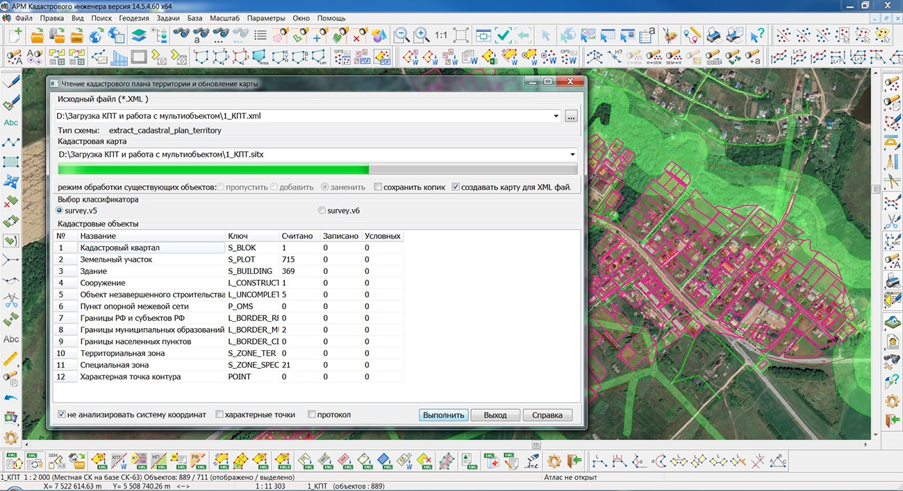
Specialists of KB "Panorama" have prepared a video lesson on importing documents from the Unified State Register of Real Estate (EGRN) and working with multi-objects. Users of the "Workstation of a cadastral engineer", or can quickly process and visualize data from EGRN extracts, cadastral plans of the territory, cadastral passports and cadastral extracts issued by Rosreestr in the format of an electronic document, using the tasks of the block . The generated digital cadastral map (DCM) can be used by cadastral engineers to prepare land-survey and technical plans.
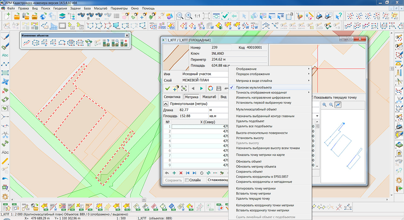
The training material demonstrates the work of the task . Obtaining cadastral information from the EGRN is carried out upon request on the public services portal of the body authorized to maintain the EGRN, or in the territorial divisions of Rosreestr. The result of the request is an XML document of the established structure defined by the XML schema. GIS "Panorama" supports a reading and processing files according to the actual XML schemas posted on the official website of Rosreestr. Loaded data can be represented as multi-objects. There is demonstrated a procedure for splitting such objects into component parts and combining them into a data set that combines several external contours of one land plot using the task .
You can get acquainted with the training materials in the "Video lessons" section.

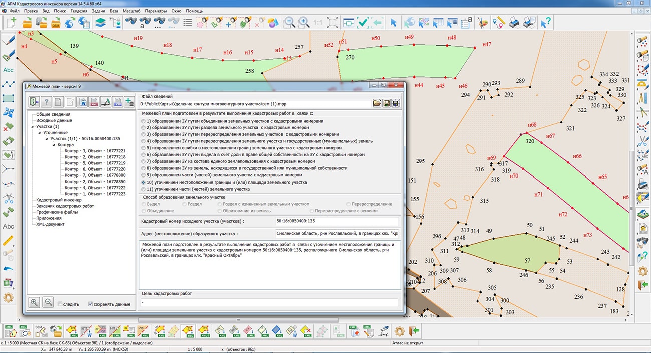
Specialists of KB "Panorama" have prepared a video lesson of formation XML of the document and the paper report of the technical plan of version 06 release 4 for recording of the construction which are a circle for cadastral registration. Users of "Workstation of cadastral engineer", or can form XML documents and paper reports of the technical plan using a complex of geodesy calculations.
The training material demonstrates the features of data preparation, filling in the mandatory characteristics and the formation of an XML file and a paper report of the technical plan version 06 in accordance with the Order of the Federal Service for State Registration, Cadastre and Cartography of March 15, 2022 No. P/0082. On the basis of this order, in the software products of KB "Panorama" the classifiers of conventional symbols survey.v5.rscz and survey.v6.rscz were developed. The classifiers implement a common list of layers, semantic characteristics and objects for displaying cadastral information on cadastral maps and other cadastral documents.
The technical plan can be formed for one or several objects of real estate depending on a variant of a choice of objects on a cadastral map. The procedures "Formation of an XML document" and "Formation of a text report" are performed in the dialog. The initial initialization of the dialog content and the specifying the type of real estate object is performed by information from the digital cadastral map, taking into account the selected mode of formation.
Elements for input and editing of the data in dialog "Technical plan" are ordered on groups, according to sections and details of the technical plan, and arranged by screen pages (tabs): , , , , and .
You can get acquainted with the training materials in the "Video lessons" section.


Specialists of KB "Panorama" prepared and placed the map of the Republic of Karelia on the geoportal . The map was formed using OpenStreetMap data. To work with the map, you can use the program or other software products of KB "Panorama".
The map was led to the modernised classifier of large-scale plans of scale 1: 5 000 (map5000m) and was saved into a packed project (MPTZ). The MPTZ format project includes a digital map of the region's territory (country, subject of the federation, administrative region), a map of the administrative-territorial division of the region and a digital classifier. Publishing of updates in bank of spatial data is made by using the program of . Publishing contents of bank of spatial data on the geoportal and data access for downloading are implemented by means of .
Free maps on the basis of OpenStreetMap data are available for download on the page "Digital maps".


In KB "Panorama" the "Workstation of cadastral engineer" version 14.5.4 has been developed. In the new version in the module, based on the materials of cooperation with representatives of the public law company , the mode has been improved. The procedure for forming a text report on the correction of registry errors has been changed and the form of the report template has been updated. When generating cadastral documents in the form of text reports and XML files, an analysis of characteristic boundary points has been added, taking into account their belonging to a specific object of cadastral works. The analysis of point objects in the points of the metrics of cadastral objects is performed taking into account the identification semantics the Cadastral or Registry number. This allows for adjacent cadastral objects with common border sections to use different sets of point objects - characteristic points of the borders.
The and modes have been improved taking into account the new algorithm for analyzing the characteristic points of the borders. The designation of a characteristic point or part of the border, information about the root-mean-square error in determining the coordinates of the point, fixing on the ground and other characteristics of the point is filled in taking into account the identification semantics of the object of cadastral works and adjacent cadastral objects. The formation of the ObjectsRealty element the "Information about real estate objects located on the formed/modified land plot" has been improved in terms of recording the additional elements ApartHouse "Apartment building" and PropertyComplex "Enterprise as a property complex (PIC)". To enter the necessary information about real estate objects located on a land plot, the mode has been improved. When editing the item "Buildings constructions (list)", a dialog is called for entering the values of four repeatable semantics, including "Attribute of an apartment building" and "Attribute of an enterprise as a property complex".
In the module the mode is updated. Calibration of linear object by data from file CSV is realised. In a mode is realised a rounding off of geodetic co-ordinates to 10 signs after a decimal point. On a position of marker ROW01 the insert of geodetic co-ordinates WGS-84 from object of a map - a forest plot binding is realised. The search for the binding object is performed automatically, and it is mapped in advance and the necessary identification semantics, the Number of the cutting area, are filled for it.
The new version of the program is available on the website in the Download section.


Specialists of KB "Panorama" have tested for compatibility of the programs , , with . Testing confirmed the compatibility and correctness of the software of GIS "Panorama", GIS "Operator" SE, GIS Panorama Mini and OS "Alt Workstation" 10. Desktop GIS provide users with tools for accumulation, storage, automated processing and display of data, calculation results and forecasts with geospatial reference. The programs allow you to create vector, raster and matrix maps, as well as quickly update various information about the area.
GIS "Panorama" is the universal geographic information system that has tools for creating and editing digital maps and city plans, processing remote sensing data, performing various measurements and calculations, overlay operations, building 3D models, processing raster data, tools of preparing graphic documents in digital and printed form, as well as tools for working with databases. GIS is used for mapping, land management and cadastre, geodetic surveys, and the creation of geoportals. The GIS is included into the Unified register of Russian programs for electronic computers and databases (registry entry No.4227 dated March 29, 2018).
GIS "Operator" SE - universal domestic geoinformation system for power structures. The program is intended for accumulation, the storage, the automated processing and display of the data, results of calculations and the forecasts having a geospatial binding. A GIS Operator SE contains means of display and processing of vector, raster and matrix maps. The appendix gives to users tools for the decision of specialised problems of modelling of movement of special objects against 3D-model, forecasting of consequences of emergency situations for dangerous objects, monitoring of movement of aircrafts, carrying out of geodetic and topographical works, data processing from navigating devices GPS/GLONASS, the press of the displayed spatial data on the various output equipment and many other things. GIS Operator SE it is certificated on 2 level of control of absence of not declared possibilities in МО the Russian Federation, it is brought in the Uniform register of the Russian programs for electronic computers and databases (record in the register № 10628 from 5/27/2021).
GIS "Panorama Mini" is the universal geoinformation system designed to collect spatial data, maintain a database of spatial data, create and update digital maps and plans, and create information systems for various purposes. The GIS is included in the Unified register of Russian programs for electronic computers and databases (registry entry No.7226 dated 11/03/2020).
is a distribution kit based on the Linux kernel, which includes an operating system and a set of applications for efficient work that supports various additional equipment. "Alt Workstation" is designed to be installed on both physical and virtual machines. It is possible to use the distribution kit as a thin client for systems with booting over the network and connecting the user's home folder from the server (when using the ALT domain). The distribution kit of the operating system is included in the Unified register of Russian programs for electronic computers and databases (registry entry No. 1292 dated 09/05/2016).


Ph.: +7 (495) 739-0245, +7 (925) 221-1603
www.gisinfo.ru | panorama@gisinfo.ru
105005, Russia, Moscow, Baumanskaya Street 7, building 1, office 229 (m. Baumanskaya)
Copyright © Panorama Group 1991 - 2024


 Mobile version
 Full version