Copyright © Panorama Group 1991 - 2024

In KB "Panorama" the "Workstation of cadastral engineer" version 14.5.3 has been developed. In the new version the mode has been added. The form of the forest declaration, the procedure for filling out and submitting it, the requirements for the format of the forest declaration in electronic form were approved by the order of the Ministry of Natural Resources and Ecology of the Russian Federation dated April 29, 2021 N 303.
Formation of the forest declaration is carried out for selected objects of the map - forest areas. The map is created using the forestry.v2 digital classifier. Entering information for filling the form of the forest declaration is performed in the dialog by entering values or selecting elements from reference books of the unified regulatory and reference information of the federal forestry agency. Reference information is stored in SQLite database tables.
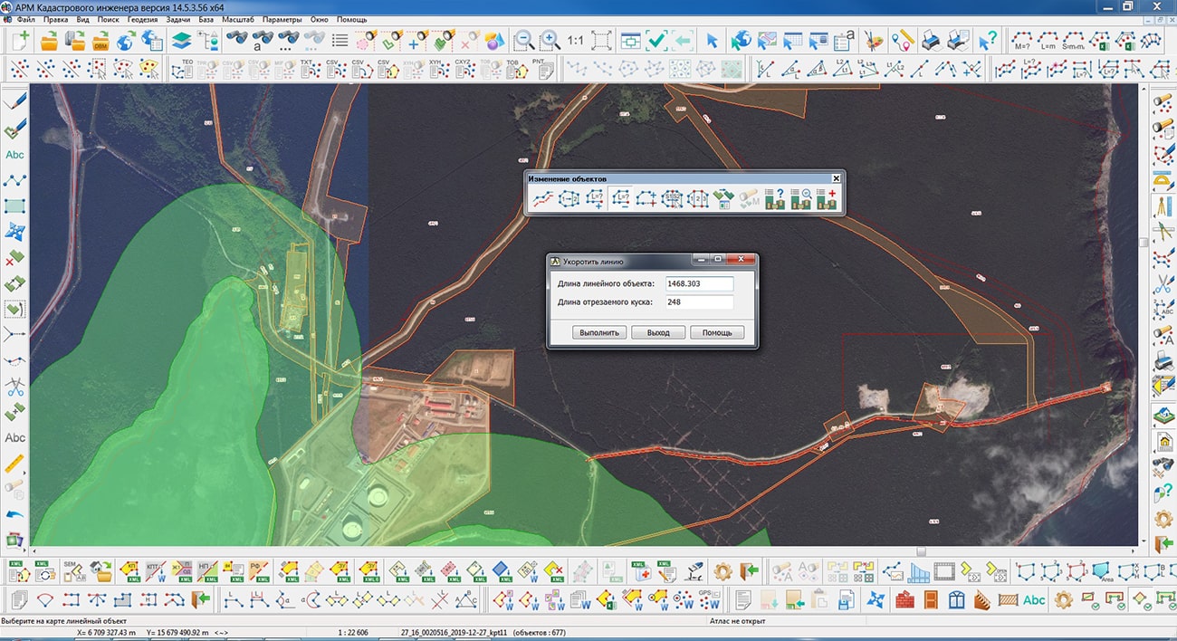
The new mode provides cutting from a linear object at the beginning or at the end of the metric of a section of a specified length.
The mode mode has been improved, which provides group filling of cadastral attributes. Using this mode, you can fill in the semantics "Cadastral numbers of buildings" for land plots. The program searches for real estate objects located inside the plots (for example, buildings), reads the initial semantics "Cadastral number" and fills in the output semantics. As a result of execution, each land plot will have the number of output semantics corresponding to the number of buildings located on it.
A new mode has been developed. The mode calculates the shortest distances in a straight line from the border of the selected objects to the specified (selected) map object. The result of calculations is mapped in the form of a linear object and a signing its length. When mapping, the standard options of the "Geodesy editor" from the "Editor" page are used. The calculated distance value is written into the semantics of a linear object.
The new version of the program is available on the website in the Download section.


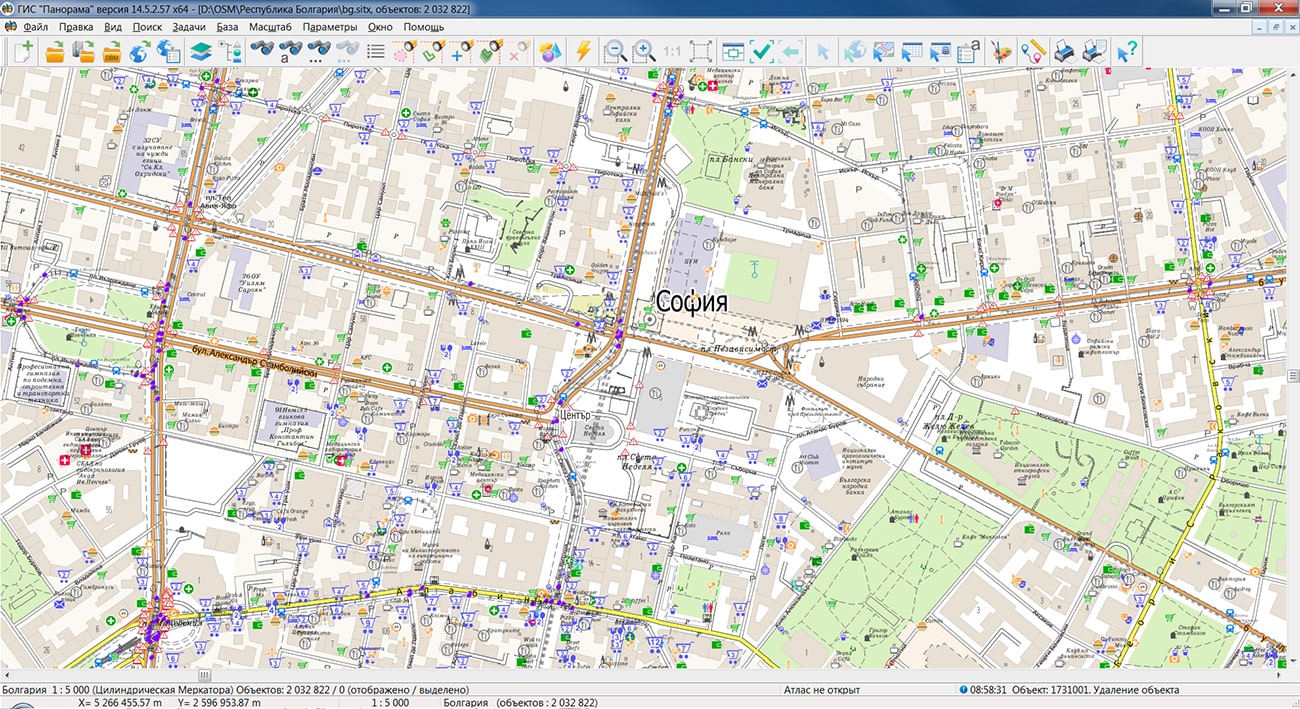
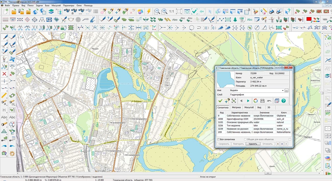
Specialists of KB "Panorama" prepared and posted on the geoportal maps of the Republics of Bulgaria and Serbia. Maps have been formed according to OpenStreetMap data. To work with maps, you can use the program or other software products of KB "Panorama".
The maps were led to the modernised classifier of large-scale plans of scale 1: 5 000 (map5000m). Publishing of updates in bank of spatial data is made by using the program of . Publishing contents of bank of spatial data on the geoportal and data access for downloading are implemented by means of .
Free maps on the basis of OpenStreetMap data are available for download on the page "Digital maps".


KB "Panorama" developed . In the new version, the task "Classifier editor" has been completely updated which controls the logical structure and classification system of vector map data. Tools for editing maps, preparing reports, processing elevation matrices have been improved, tools for preparing a forest declaration in electronic format (XML), preparing cadastral maps have been supplemented, and the complex for automated preparation of maps for publication has been updated.
The new version of the task has been developed. Information about the composition of the classifier is supplemented by the number of connected libraries with user signs, libraries of 3D signs and objects that have a three-dimensional appearance in the tab "General data". "Translation" tool has been added to translate the names of layers, objects and semantics of the classified into other languages. Operating the color palettes of the classifier is placed on a separate tab "Palettes". There is a convenient opportunity to simultaneously view and work with the colors of RGB and CMYK palettes. Adjusting the arrangement of colors in the palette table permits to arrange them with the greatest convenience for editing. For each color, there is shown the number of objects types for the classifier that use this color. This makes it possible to quickly see unused colors in the palette. The new tool "Transfer color to unused space" permits to reduce the size of the palette, if it is necessary. When a color is selected in the palette, a table of object types using this color is displayed at the bottom of the tab. From the table of types for objects on any tab, by double-clicking the left mouse button on the object, it is possible to go to the tab "Objects" to edit it. The new tool "Replace color in objects" permits to replace the selected color with another one in all classifier objects that use it. There are added tools for converting color from RGB to CMYK and vice versa. The field "Number of colors" for the palette displays the number of colors actually used in objects of the palette.
There is added the ability to create a palette of named colors. It has a tree structure and it can be used together with the main RGB palettes of the classifier. One example of its application is the stratigraphic (geochronological) scale, the geological time scale of the Earth's history. In the tab" Layers", there has been added a mode to view all layers together with their classes in the form of a tree. The tool "Classes" permits to add and edit classes for the selected layer. In the tab "Objects" there have been added tools for searching objects by name, code, symbolic code, key and other properties via "Object filter". In the subtab "Scale" there is added the ability to enter the arbitrary denominator of the scale for the lower and upper boundaries for the visibility of the object. In the subtab "Miscellaneous", there are added the properties of the object "Design object" and "Polygon with a dot". In the subtab "3D", there has been added the selection of the three-dimensional model of an object by types: near, medium, far. In the modes of creating or copying an object, all characteristics are filled in automatically. The operator is then prompted to change these fields if it is necessary. The tool "Creating and editing the series of objects" has been updated. Object properties: layer, class, visibility, additional object properties ("Miscellaneous" tab) - can be changed for all objects in the series at once or for one selected object. The tab "Clusters" has been added to describe the signs of clusters that display densely spaced point signs. The tab selects the types of objects related to each type of cluster, the cell sizes vertically and horizontally, the semantics code for specifying the current number of objects in the cluster, the type of cluster symbol, the limiting percentage for increasing the size of the cluster sign and the limiting number of objects corresponding to the maximum size of the sign cluster.
In the tab "Libraries", in the tree of custom functions for displaying objects, next to the name of the function, there has been added the number of types for objects in which it is used. When a function is selected in the object table, all types of objects that use this function are displayed in the right part of the tab. The tab "3D" has been supplemented with understandable tools for creating and connecting p3d-libraries of the three-dimensional view of objects. The enlarged view (zoomed-in view) of the selected texture has been added to make it easier to view textures when editing their composition. When the texture is selected at the bottom of the tab, there is displayed a list of objects in the 3D view of which it is used.
There has been improved the mode of the map editor which is included in the group "Cutting and stitching". The new algorithm cuts out not only areal, but also linear objects (according to the list of reference objects). By default, response points are saved in the reference objects created at the intersection of the contours for the reference and edited (cropped) objects. This method of processing lets to save the topology of the metrics for cropped objects with reference ones. If there is no need to save the topology (at intersections), then to speed up processing it is recommended to enable the option "Do not match points of edited objects with points of reference objects".
The task has been improved. There has been added the ability to automatically add the created legend to the report map as an inset map or insert an image, depending on the selected format of the saved legend in the mode "Formation of the legend".
The task for has been improved. There is added the support for the analysis of matrices in different coordinate systems. The task has been improved. The entry record has been added to the output file of the parameters of the vertical coordinate system, created in accordance with the height system of the source matrix. The file GeoTIFF stores the name of the vertical coordinate system, the height units contained in the file, and other parameters. For example: "Baltic 1977 height (EPSG:5705)", "MSL height (EPSG : 5714)", "WGS 84 (geographic 3D) (EPSG : 4327)".
The task has been improved. There is added the ability to import DEMs or images from files TIFF(GeoTIFF), IMG, KMZ contained in the selected folder. When enabling on the form of the element "Import heights from TIFF, IMG files", the control of the program is transferred to the dialog .
The new mode "Formation of the forest declaration in electronic format (XML) with attachments (appendices)" has been added to the task . The form of the forest declaration, the procedure for filling out and submitting it, the requirements for the format of the forest declaration in electronic form were approved by order of Ministry of Natural Resources and Ecology of the Russian Federation dated April 29, 2021 N 303. The forest declaration reflects information about the person who filed the forest declaration; on a lease agreement for a forest plot or other document in accordance with which the use of forests is carried out; about the location of the forest area; on the volume of forest use; on the types of forests use, which are provided for by the forest lease agreement, or other document in accordance with which the use of forests is carried out, the forest development project for the declared period. Formation of the forest declaration is carried out for selected objects of the map - forest areas. The map is created using the digital classifier forestry.v2.rsc. Entering information to fill in the forest declaration form is performed by selecting values from the reference book and from the semantic characteristics of the selected objects. The reference information is stored in the database tables SQLite.
The module has been improved. A new mode "Shortening the line (input distance)" has been developed. The mode provides cutting off from a linear object at the beginning (or at the end) of a segment of the specified length. The mode is included in the panel "Objects changing". The mode "Transfer of semantics to selected objects" has been improved. To perform the operation, it is necessary to select land plots on the map, for which it is necessary to fill in the repeatable semantics "Cadastral numbers of buildings" (code 1061). Next, in the mode dialog, specify the type of objects located inside the plots (for example, buildings), the initial semantics (Cadastral number, 1001) and the output semantics. As a result of execution, each land plot will have the number of output semantics corresponding to the number of buildings located on it. A new mode "Writing the shortest distance to selected objects" has been developed. The mode calculates the shortest distances in a straight line from the border of the selected objects to the specified (selected) map object. The result of calculations is plotted on the map in the form of a linear object and writing of its length. When plotting, the standard settings of "geodesic editor" are used, the page "Editor". The additionally computed distance value is written to the line semantics.
There are improved tools for automated map preparation for publication. There are added script procedures "Classification of captions by location" and "Removal of coinciding contours". In accordance with the design rules on topographic maps of scales 1: 25,000, 1: 50,000, 1: 100,000, conventional signs such as "Forest strip", "Power lines", "Communication lines", "Glades" ("Clearings") and road network objects are written by one type of caption "Explanatory captions and characteristics (T-132) 1.3 mm". From the point of minimizing view for the size of the digital classifier, this approach is optimal. From the point of view for automated processing when generalizing a map or preparing for publication, such approach is harmful: it is impossible to unambiguously determine whether a caption belongs to the written object. When performing these works, some fragments of linear objects can be removed, displaced, or change the shape of the contour (in the process of filtering, generalizing and smoothing the metrics). When deleting a contour, the corresponding caption with the characteristics of this contour should be deleted. When changing the contour, the position of the caption should be specified (alignment of the caption metrics with the road contour, or offset from the road by the specified distance). The procedure "Classification of caption by location" permits to automatically assign certain types of signs "Characteristics of the forest strip", "Characteristics of power lines", "Characteristics of communication lines", "Characteristics of clearing", "Characteristics of the road", "Road number". The classification of captions permits the separate processing of each type of captions. Captions of the type "Road number" are obsolete and can be removed: currently the vector sign "Road number" is written with text from the semantics "Road number", the width of the sign frame is calculated automatically according to the length of the caption. Captions "Characteristics of the forest strip" located on top of the signs "Forest strip" near the road can be automatically shifted by the required distance. Automatic displacement of captions is performed using the script procedure "Refining the position of vector characters".
The procedure "Removal of coincident contours" permits to automatically remove fragments of highways and trunk roads, the metrics of which partially coincide with vector bridges and captions of the type "Road characteristics". Before executing this procedure, the road intersections are processed. White and orange road decoration lines are created over the roads, masking the black outlines at intersections. Then the procedure "Removal of coincident contours" is performed, as a result of which fragments for the external black contours of roads are removed at the intersections with bridges and captions. The middle orange lines of the road design are saved.
The procedure for the scenario has been improved. This procedure performs the displacement of objects relative to the linear objects of the road network (taking into account the width of the roads). There is added processing of captions and point characters. The processing of captions is performed when specifying the position of the caption "Characteristics of the forest strip". Point signs are processed when specifying the position of individual trees. Procedures are launched in the dialog "Map Processing by Script", which is called via the main menu: Tasks - Preparing for Publication - Map Processing by Script.
There is improved RAM distribution when processing large data sets (tens of gigabytes and more than a hundred million objects). The speed of searching and displaying data has been improved. The new version of the program is available for download on the page .


KB "Panorama" has developed version 11.1.0. The new version implements the ability to cut pyramids of tiles according to geo data obtained from free sources. The source data can be mpt projects containing connections to web services and servers. Pyramids of tiles can be created based on a combination of digital vector maps, space and aerial photography, elevation matrices, data from geoportals and other data. To read the source data, the program can connect to or open data sets in the local network. The list of supported geoportals is published in the settings file wmslist_en.xml. The list of connections can be extended by the user. There are supported the arbitrary geoportals according to standards OGC WMS, WMTS, WCS, WFS, WFST.
The program monitors data changes according to the transaction log for vector data, according to the time of updating raster and matrix data, and automatically updates those tiles on which changes have occurred.
Imagery Creator permits to cut tiles into geospatial databases running PostgreSQL, MS SQL and Oracle, in accordance with the standard OGC 06-103r4: "OpenGIS Implementation Standard for Geographic information - Simple feature access - Part 1: Common architecture". Communication with the database is carried out on the basis of the preconfigured file (project) dbm created in the service administrator. DBM file contains the description of the parameters of a digital vector map, in the form of which a data set from the database (table, view or result of the query SQL) will be displayed. As part of the parameters are indicated: the conditional name of the map; RSC classifier file containing a library of symbols; coordinate system code (standard EPSG code or custom code from crslist.xml file); map scale, in which symbols are displayed on the unit scale (in the dimensions specified in the classifier).
The program generates tiles in formats JPEG, PNG, PNG8, Mbtiles, BIR and GeoPackage according to the international standard OGC WMTS 07-057r7 version 1.0.0, TMS standard and OGC 12-128r15 GeoPackage version 1.2.1. Tile data generated by the program Imagery Creator are used by software products , to ensure high speed of requests execution for displaying spatial data over vast areas while simultaneously accessing a large number of users. The new version of the program is available on the page .


KB "Panorama" has developed version 10.5 for operating systems Astra Linux SE, Ubuntu 18.04, CentOS 8, CentOS 7 and MS Windows. The new version of the program has improved support for reading large maps (tens of gigabytes and more) on slow hard drives with simultaneous multi-user editing of these maps, which speeds up data reading by an order of magnitude when opened. Diagnostic messages have been updated and support for operations on files in virtual folders has been improved for a large number of users and groups with different access rights for users belonging to several groups at once. There is added error handling of input data when opening spatial databases via DBM parameters. There is added support for new metadata tables in Data Bank of digital maps and remote sensing.
There is accelerated control of the state for data availability schemes in . The analysis of metadata uploaded to Data Bank has been improved. It is improved support for map editing through connection to a chain of GIS Servers in the distributed data storage system during long-term intensive multi-user work with shared data sources.
The new version of the program is available for download on the page .


Ph.: +7 (495) 739-0245, +7 (925) 221-1603
www.gisinfo.ru | panorama@gisinfo.ru
105005, Russia, Moscow, Baumanskaya Street 7, building 1, office 229 (m. Baumanskaya)
Copyright © Panorama Group 1991 - 2024


 Mobile version
 Full version