Copyright © Panorama Group 1991 - 2024

In KB "Panorama" the version 14.3.0 has been developed for creating GIS-applications. The new version expands the possibilities for formation, updating and analysis of digital terrain models by including into the software of scripts in language which can be written in any text editor.
A new function (RunPyApplication) has been added that calls the dialog with the bookmark for executing scripts in the Python language. In a tree of scripts, node the Basic set of scripts is initially set which contains the scripts supplied together with GIS ToolKit. To connect user scripts, you can create your own nodes (themes) for their grouping. The basic set of scripts demonstrates the execution of various procedures for processing the coordinates and attributes of vector map objects, solving the computational problems, converting data and other tasks.
When writing scripts, several thousand API function are available. Function prototypes are declared as imported Python scripts from the folder \\GisTool14\Dll\X64\py_mapapi14. For proper processing of script strings containing national characters (Russian, Chinese, Spanish, and so on), the scripts must be encoded in UTF-8.
The function called from the script can perform some action on the selected object or on selected objects if the user has selected some objects on the map. To enter additional data processing parameters, both GIS dialogs and dialogs written on the basis of the standard tkinter component can be called. Scripts can indicate the progress of data processing by indicating the name of the processing stage, the percentage of execution, the number of processed and selected objects, the elapsed and remaining processing time. Based on the results of the analysis and processing of vector map objects, some objects can be selected that can be marked on the map as a result of working the script and/or for further processing in the chain of executed scripts or by interactive GIS tools.
To execute scripts, you must first download and install the Python interpreter. The basic set of scripts has been developed and tested based on Python version 3.7.9 on MS Windows 7 and higher, and version 3.10.5 on MS Windows 10. The base scripts are located in a shared folder like: \\GisTool14\Dll\X64\py_base14. A demonstration of working the RunPyApplication function is provided in the MapEdit application included into examples of the GIS ToolKit.
The GIS ToolKit consists of a set of visual components (supplied in source code) and API functions of the GIS core for direct access to spatial data. The toolkit is designed to develop client-server and desktop 32-bit and 64-bit applications that require processing and visualization of spatial data. Spatial data can be located both at the workplace (direct access to data), and in a local network or the Internet (access components to the or data exchange using international protocols are used).
The new version of the program is available for download on the Download page.


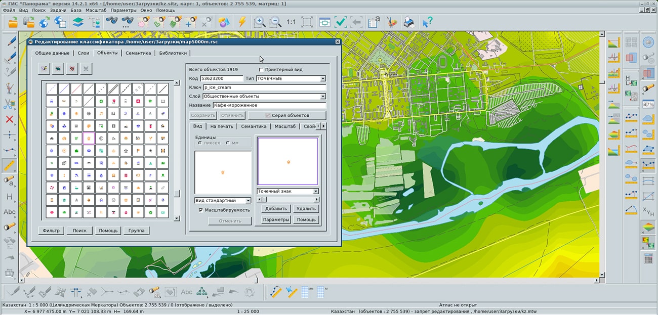
Specialists of KB "Panorama" prepared and placed the maps of Kursk and Smolensk regions on the geoportal . The maps were formed using OpenStreetMap data, source data was obtained from website. To work with the maps, you can use the program or other software products of KB "Panorama".
The maps were led to the modernised classifier of large-scale plans of scale 1: 5 000 (map5000m) and were saved into a packed project (mptz). Publishing of updates in bank of spatial data is made by using the program of . Publishing contents of bank of spatial data on the geoportal and data access for downloading are implemented by means of .
Free maps on the basis of OpenStreetMap data are available for download on the page "Digital maps".


KB "Panorama" has prepared new versions of desktop GIS-applications for the operating system "Alt 8 SP" (architecture x86-64). The line of software products for OS "Alt 8 SP" includes universal geoinformation systems the , and . They provide users with tools for accumulation, the storages, the automated processing and display of the data, results of calculations and the forecasts having a geospatial binding. Systems allow to create vector, raster and matrix maps, and also quickly to update the various information about the area.
GIS "Panorama" is the universal geographic information system that has tools for creating and editing digital maps and city plans, processing remote sensing data, performing various measurements and calculations, overlay operations, building 3D models, processing raster data, tools of preparing graphic documents in digital and printed form, as well as tools for working with databases. GIS is used for mapping, land management and cadastre, geodetic surveys, and the creation of geoportals. The GIS is included in the Unified register of Russian programs for electronic computers and databases (registry entry No.4227 dated March 29, 2018).
GIS "Operator" SE - universal domestic geoinformation system for power structures. The application provides users by tools for solving specialized tasks of modelling the movement of special objects on the background of 3D-model, aircraft movement monitoring, processing data from GPS/GLONASS navigation devices, printing displayed data onto various output devices, and many others. The map editor included into the software product, is equipped by the expanded set of modes for drawing of operative situations with use of a view of the objects specified by the user. GIS Operator SE is certified according to the 2nd level of control of the absence of undeclared capabilities in the Ministry of Defense of the Russian Federation, it is included in the Unified register of Russian programs for electronic computers and databases (registry entry No.10628 of 05/27/2021).
GIS "Panorama Mini" is the universal geoinformation system designed to collect spatial data, maintain a database of spatial data, create and update digital maps and plans, and create information systems for various purposes. The GIS is included in the Unified register of Russian programs for electronic computers and databases (registry entry No.7226 dated 11/03/2020).
is a domestic operating system of general purpose. This operating system is highly appreciated not only by government agencies and corporations, whose exactingness in the quality of IT solutions is a clear marker of their high level of reliability, but also by ordinary users, because of the convenience and compatibility with most products of domestic and foreign software and hardware manufacturers. The use of OS "Alt 8 SP" allows you to create a trusted digital environment for working with confidential information and personal data. On the basis of OS "Alt 8 SP" you can create a full-fledged workstation for solving almost all everyday tasks: working on the Internet, with office or multimedia tools, as well as with applications that require maximum use of the capabilities of graphic video cards, including geographic information systems.
New versions of the program for OS "Alt 8 SP" are available for download in the section.


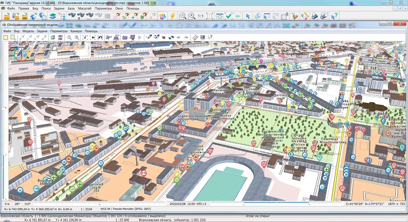
Specialists of KB "Panorama" prepared and placed the maps of the Voronezh and Ivanovo regions on the geoportal . The maps were formed using OpenStreetMap data, source data was obtained from website. To work with the maps, you can use the program or other software products of KB "Panorama".
The maps were led to the modernised classifier of large-scale plans of scale 1: 5 000 (map5000m) and were saved into a packed project (mptz). Publishing of updates in bank of spatial data is made by using the program of . Publishing contents of bank of spatial data on the geoportal and data access for downloading are implemented by means of .
Free maps on the basis of OpenStreetMap data are available for download on the page "Digital maps".


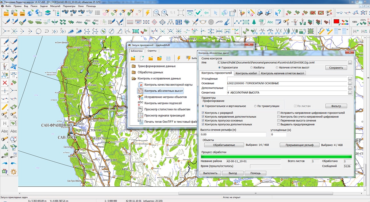
In KB "Panorama" the professional vectorizer version 14.3.2 has been developed. In the new version, the tools for creating and checking the quality of digital terrain maps, building reports and processing multispectral images have been improved. GIS capabilities for creating, updating and analyzing digital terrain models have been expanded by including into the software of scripts in language that can be written in any text editor.
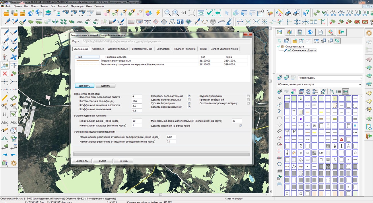
In the new version, the has been improved. Support for national maps and classifiers was added that have contour lines of different types with the same external code. This allows you to control the correctness of the formation of contour lines, both for classifiers containing separate series of objects for different types of contour lines: Thick horizontals, Thick horizontals on glaciers, Thick horizontals on rocks; Main contours and so on, and classifiers with one code (series) for all types of contour lines - in this case, control of contour heights is customized and performed by object keys. The GIS also includes the task, which is designed to check the structural integrity of digital data, the completeness and quality of the metric and semantic description of objects, and to automatically correct detected errors.
The task has been improved. In the "Break down objects onto component parts" mode, the ability to process multipoint objects with subobjects has been added. This allows you to break the point objects onto a group of independent objects, consisting of sub-objects, each of which, in turn, contains several points.
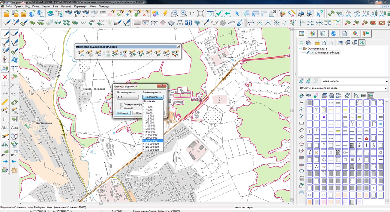
The task has been improved. On the "Maps", "Rasters", "Matrixes", "Models" bookmarks, an information sign "(!)" is set if the coordinate system of the added data does not match the current coordinate system of the main document. On the "Maps" bookmark, an updating the content of the classifier tree has been improved when changing the contents of vector map objects. For example, if the filter "Objects available on the map" is set in the "Map legend", when an object is placed onto the map that is not part of the tree, the legend will be automatically rebuilt. In the "Map Legend" and "Data List" tasks, the updating of visibility of maps, rasters, matrixes and geoportals is synchronized.
The task has been improved. In the object geometry editing mode, the functions of deleting objects, interactively changing the height of the signature font, adding and deleting borders for insets have been added. There are added a display of the background grid and setting its parameters: display, color, view, position on the map, the ability to disable when exporting a report to graphic files, permission to stick the cursor to grid nodes when creating and editing objects. In the insertion mode, the ability to stick the cursor to grid nodes has been added, the ability to interrupt an unfinished operation has been added. In the object geometry editing mode, the function of binding all points of object to grid nodes has been added. Grouping of buttons has been made. Rarely used modes are designed into group buttons with the ability to select a specific mode through the menu. When saving stamps, the ability to decode objects (from an object with a classifier code into a graphic object) has been added, which allows you later to load this stamp into a map with any classifier. In interactive modes the hints in the info line have been added.
In dialog the bookmark for executing scripts in the Python language has been added. The "Basic set of scripts" node is initially installed in the script tree, which contains scripts supplied with the GIS. To connect user scripts, you can create your own nodes (themes) for their grouping. The basic set of scripts demonstrates the execution of various procedures for processing the coordinates and attributes of vector map objects, solving the computational problems, converting data and other tasks. The basic scripts are located in a shared folder like: \Users\Public\Documents\Panorama\py_base14 .
For multispectral rasters imported in the "Do not copy the input image to RSW file" mode, support for channel color depth of 32 and 64 bits has been added. To convert the color to 8 bits, the minimum and maximum values determined by the reduced image are used during display. Single-channel rasters with real pixel encoding, which are usually used to store matrix height data, are displayed in grayscale.
The item has been added into the context menu, which contains a list of the latest executed commands in various tasks and the executed applications from the "Run applications" dialog.
For immediately calling a list of latest commands, use the combination of the Shift key and the right mouse button.
The new version of the program is available for downloads in the Download section.


Ph.: +7 (495) 739-0245, +7 (925) 221-1603
www.gisinfo.ru | panorama@gisinfo.ru
105005, Russia, Moscow, Baumanskaya Street 7, building 1, office 229 (m. Baumanskaya)
Copyright © Panorama Group 1991 - 2024


 Mobile version
 Full version