Copyright © Panorama Group 1991 - 2024

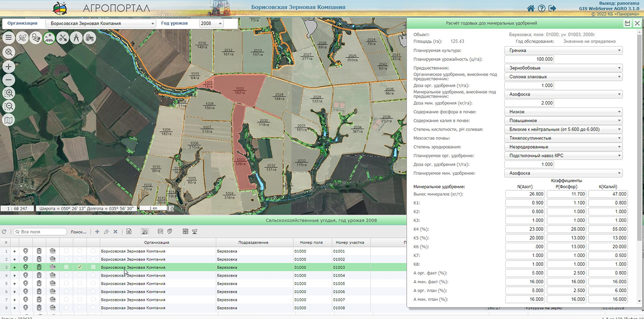
In KB "Panorama" the version 3.1 has been developed. The new version adds the ability to keep records of the processing the fields with plant protection products (PPP) with use of the information from the unified directory of pesticides and agrochemicals. For each field, a list of plant protection products is formed, taking into account the order of application, date and type of processing (ground or from air) of plants.
The unified reference book is filled with information from the State catalog of pesticides and agrochemicals approved for use on the territory of the Russian Federation and contains the name of the active substance, the hazard class for humans, and the hazard class for bees in the field conditions. One of the main reasons for the death of bees in many countries of the world, including Russia, is the steady increase in the use of pesticides in agriculture. According to the appraisal of management of the , recently the volume of pesticide use in Russia has increased annually by 6-8% and this trend will continue for a long time. The list of pesticides and agrochemicals registered in Russia includes more than a thousand items. However, today no one knows exactly what preparations and in what quantities are applied by agricultural producers. The use of a unified directory of pesticides and agrochemicals makes it possible to unify the calculation of the danger of using plant protection products for people and bees.
In new version of GIS WebServer AGRO the possibility of work with projects has been expanded that allows to set automatically project's settings (current organization and crop year). There are added a loading and selection of multipoint objects in the map, the ability to create and edit objects of the "Polygon with a point" type. "Map Editor" and administration module have been updated.
Synchronisation of the cartographical information described in base "Panorama АГРО" and the information published in , is carried out automatically.
For collective work with the data the digital maps of farmland and an enterprise infrastructure are placed on the . Its application allows you to synchronize the work of the desktop , web applications and mobile clients. Desktop applications such as , "Workstation of agronomist" and others can be connected to the GIS Server. It allows the mobile clients working through web, to process the same data together with desktop clients. You can get acquainted with an example of the work of GIS WebServer AGRO on the page of the demonstration project.
The new version of the program is available on the website in the Download section.


Specialists of KB "Panorama" have prepared a video lesson of about the termination of existence of a building, construction, object under construction, premises, parking spaces. Users of "Workstation of cadastral engineer", or can form inspection's certificates of real estate objects by means of a complex of geodesy calculations.
The training material demonstrates the features of data preparation, a filling the mandatory characteristics and the formation of an XML document the Certificate of inspection confirming the termination of existence of object of real estate according to requirements of Order of Rosreestr № P/456 of September 30, 2014 of year and the printed version in accordance with the requirements of the Order of Rosreestr № P/0217 of May 24,2021. On the basis of these orders in software products of KB "Panorama" the classifiers of conventional symbols and have been developed. In classifiers there are implemented the general list of layers, semantic characteristics and objects for displaying cadastral information on cadastral maps and other cadastral documents. A source of data for formation of the certificate of inspection of real estate object is a map object, which can be put schematically, but provides formation of a database in the form of a cadastral map.
You can get acquainted with the training materials in the "Video lessons" section.


In KB "Panorama" the version 14.3.1 has been developed. In the new version the tools for selecting and analyzing events from remote video cameras, connecting geoportals, editing maps of the area and designing aeronautical maps have been improved.
Options for working with have been expanded. Now the user can select the types of events for which he wants to receive notifications from the video camera. Events include: movement of people, cars and other objects in the video camera's visibility field, crossing the perimeter of a closed zone, appearance or disappearance of objects in the frame, detection of facts of vandalism and sabotage. To receive event notifications, the video camera must support appropriate video analytics and the ONVIF standard for Internet communication.
New features provide filtering of event notifications from the video camera. The operator can select the types of events that interest him in the dialog , which is called in the "List of photo and video data" mode of the task. The dialog displays a list of event types supported by a particular video camera. Events are grouped by topics. At the top level of the hierarchy, the groups correspond to the main video camera services. These include: a video analytics service, a media service, a service of camera status monitoring, etc. At the lower levels, events are grouped according to clarifying features. For example, events from the video analytics service are divided into events related to motion detection in the frame, field detection (perimeter intrusion, the appearance or disappearance of objects), object detection (person, car), etc. If authorization is required when connecting to a camera, and it has not been saved earlier, then its parameters will be requested from the user before opening the "Setting up an event filter" dialog. After the user has marked all the events of interest to him, the subscription to receive events is activated. Viewing event notifications will be available in the camera video view window.
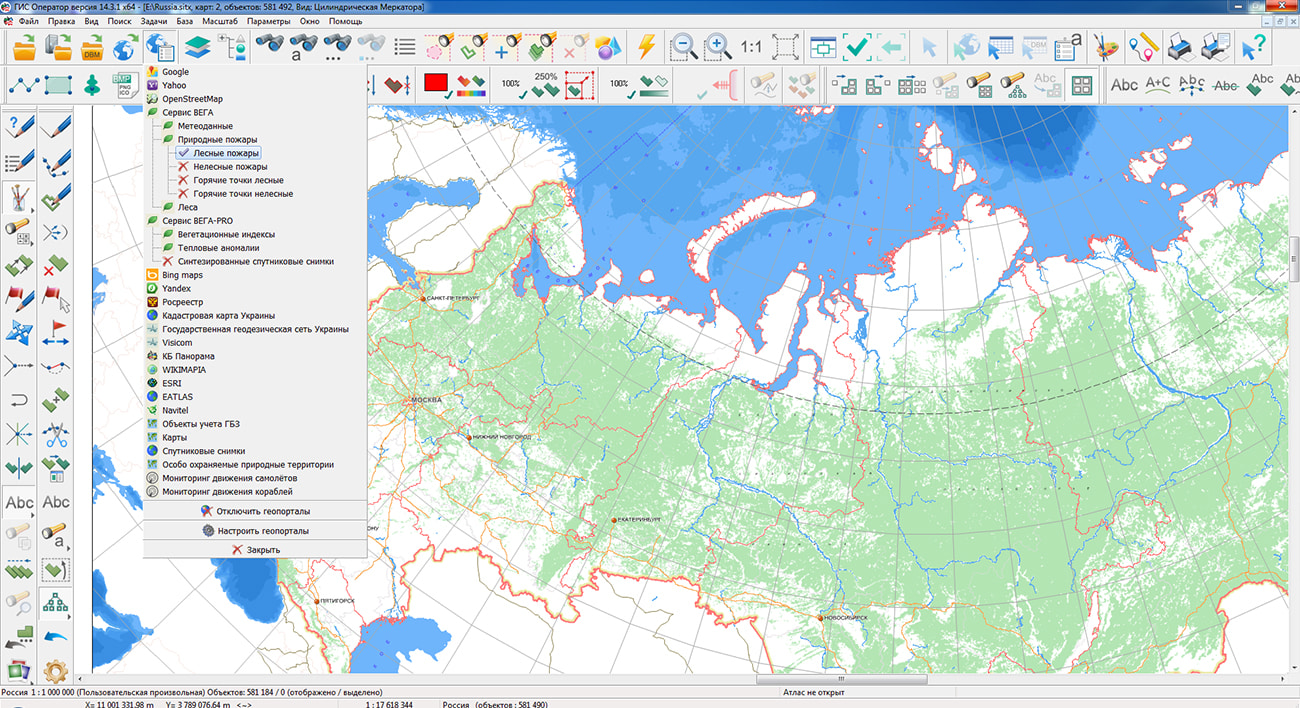
The task of has been improved. Ability to access archived data from geoportals has been added. The archives may contain data on the state of the area for a certain period of time or other geospatial information. Examples of such data can be remote sensing data, electronic field maps, thematic maps, weather maps, geological, geographic, geophysical, engineering and other data. For example, using this task, you can connect fire maps provided by the Information System for Remote Monitoring of the Federal Forestry Agency (Rosleskhoz). This system provides data from aviation and ground observations, from satellite monitoring of forest fires, from a lightning direction finding system. Access to information is carried out taking into account the specified time interval of observations.
Conventional symbols have been added into the classifier of aeronautical maps to display the signatures of the minimum absolute flight altitude in the area with the value displayed in meters or feet. The symbols are designed in accordance with the requirements of Doc 8697 ICAO Guidelines for Aeronautical Charts.
The new version of the program is available for download in the section.


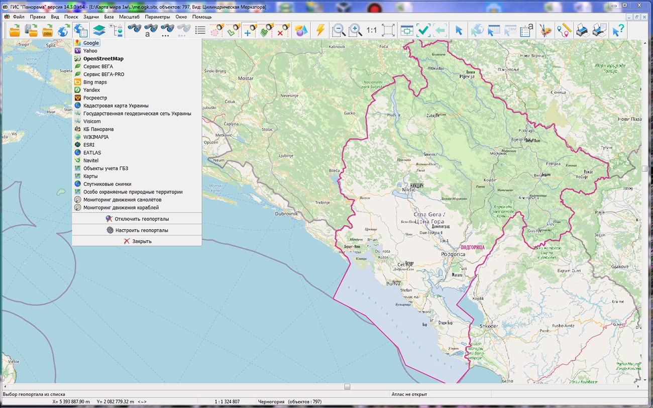
In KB "Panorama" the digital geographic maps of scale 1: 1 000 000 in format SITZ onto territory of Montenegro and the Republic of Serbia have been prepared. As a source for preparation of the map the obtained from the information from the site has served. The maps contain information on the number of inhabitants for cities and the name of settlements in Russian. As additional materials the World map of scale 1: 5 000 000 and data were used.
The maps were led to the classifier of geographic maps of scale 1: 1 000 000 (). It can be used for a general assessment of the area and the study of natural conditions, to ensure the educational process, as a basis for the creation of geographic maps of a smaller scale, thematic and special maps, and solving other tasks. The map is distributed free of charge under a free .
Digital geographic maps of scale 1: 1 000 000 in SITZ format are available for download on the page "Digital maps".


In KB "Panorama" the version 14.2.0 has been developed for OS "Astra Linux Special Edition" (Release "Smolensk") and OS "Alt 8 SP" (architecture "Elbrus"). In the "Map Editor" task, the image of typical elements: edited and auxiliary objects and vertices is reduced to a general view. Flickering of map elements during various editing operations is excluded. This allows you to more effectively perform typical actions when preparing various types of vector maps. Each concrete user can perform personalization of options of data editing (color and thickness of lines of objects, contours and nodes) by means of dialog "Editor options".
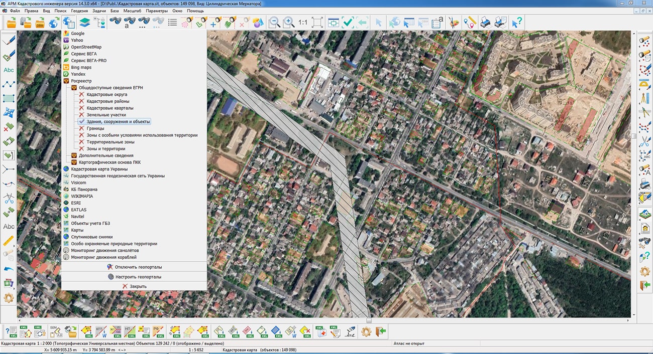
Tools for connecting geoportals has been improved. There is added a support for arbitrary user matrixes in local coordinate systems with user-defined reference points and arbitrary axes direction. It will allow to connect any data in BIR and GeoPackage format. Support of seamless coverings from Bank of base products of the Russian space systems (RSS) has been added. Access is based on the api-key obtained in the user's personal account. The bank contains data from various spacecraft, such as BKA, KANOPUS-B, KANOPUS-V-IK, METEOR-M, RESURS-P and others. Seamless coverings are presented in the form of a tile substrate for various territories of the Russian Federation in separate regions. Support of OpenStreetMap geoportal has been improved. New layers of data were added: map of airports, humanitarian map, map of transport.
Conventional symbols have been added into the classifier of aeronautical maps to display the signatures of the minimum absolute flight altitude in the area with the value displayed in meters or feet. The symbols are designed in accordance with the requirements of Doc 8697 ICAO Guidelines for Aeronautical Charts.
The structure of storing arrays of colors for primitives of 3D-models of the DB3D format has been improved. Import of a cloud of points from MTD format into format DB3D has been changed. Display of DB3D-models with use of new possibilities of a format was improved.
Geographic information system GIS "Panorama" is the universal geographic information system that has tools for creating and editing digital maps and city plans, processing remote sensing data, performing various measurements and calculations, overlay operations, building 3D models, processing raster data, tools of preparing graphic documents in digital and printed form, as well as tools for working with databases. Geographic information system GIS "Panorama" is registered in the Unified Register of Russian Computer Programs and Databases (№4227).
Certified operating system "Astra Linux Special Edition" "Smolensk" release version 1.7 has built-in verified information security tools. This is a fault-tolerant platform for secure IT infrastructures of any scale and work with data of any degree of confidentiality. This operating system is highly appreciated not only by government agencies and corporations, whose exactingness in the quality of IT solutions is a clear marker of their high level of reliability, but also by ordinary users, because of the convenience and compatibility with most products of domestic and foreign software and hardware manufacturers. On the basis of the "Smolensk" release, you can create a full-fledged workstation for solving almost all everyday tasks: working on the Internet, with office or multimedia tools, as well as with applications that require maximum use of the capabilities of graphic video cards, including geographic information systems.
Certified operating system is a universal distribution kit that includes an operating system and a set of applications for full-fledged work that supports various equipment. The OS is designed for everyday work on personal computers. Convenient graphical interface, rich set of applications, resistance to malicious attacks. It is based on MATE desktop environment. Includes an office suite, applications for working on the Internet, applications for working with graphics and music files, as well as many other necessary programs.
The new version of the program is available for download in the section.


Ph.: +7 (495) 739-0245, +7 (925) 221-1603
www.gisinfo.ru | panorama@gisinfo.ru
105005, Russia, Moscow, Baumanskaya Street 7, building 1, office 229 (m. Baumanskaya)
Copyright © Panorama Group 1991 - 2024


 Mobile version
 Full version