Copyright © Panorama Group 1991 - 2024

In KB "Panorama" the version 6.3.0 for the has been developed. The complex is designed to create surface models and solve problems of spatial analysis using the constructed models. In the new version of the program, tools for combining matrixes of elevations and tools for profiling the terrain surface have been improved.
In the task, the "Rejection of matrixes with elevations outside the specified range" mode has been added. The mode is intended for estimating the elevations of a set of united matrixes and determining the composition of data with reliable elevations. Matrixes with elevations outside the specified range are removed from the list of matrixes and moved into a separate directory. The "Summ elevation matrixes" task is intended for creating a file of matrix of elevations according to one or several open matrixes. Task execution in a mode of smoothing of elevations allows to eliminate sharp differences of elevations of the resulting surface.
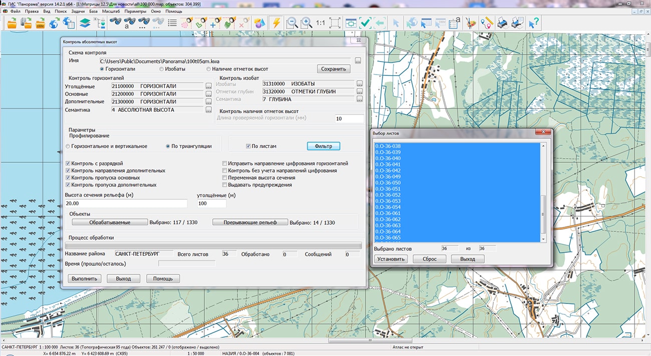
The profiling mode "By triangulation" of the task has been improved. There are added a processing mode "By sheets" and the ability to select individual sheets of the region using the "Filter" button. The "By sheets" mode does not detect erroneous elevations differences between objects of different sheets, but it is performed 5-6 times faster than processing in the region, since triangulation is built for each sheet separately with a smaller number of edges (profiles). For the processing mode in the region, the issuance of unnecessary messages caused by the passage of profiles through the areas of sheets absence in the case of a non-rectangular form of region has been eliminated. Processing time indicator "Time (used/remain)" has been added.
A new type of profiling of map objects has been developed - by triangulation edges. The triangulation vertices are: a point object (height mark, GGS point, waterline mark), a metric point of an areal object with an absolute height (lake, reservoir), a horizontal metric point.
For a flat terrain with a large number of elevations and a small number of isolines, the "By triangulation" profiling mode eliminates misses that are possible when searching for heights in horizontal and vertical directions, which reduces the number of uninformative messages and facilitates the analysis of control results. The task is intended for constructing relief surface profiles using the matrix of elevations MTW, TIN-model and MTD-model, as well as for displaying sections of geological layers and thickness graphs at a given point using the layers matrix (MTL).
The "Complex of 3D analysis" includes specialized tasks of relief analysis, modelling of derivative surfaces, creations of vector characteristics, tasks of forecasting and an accuracy estimation. The surface's model can display various properties of terrain, such as relief heights, concentration of pollution, amount of precipitation, level of radiation and others. Models of surfaces can be created by vector data of formats SHP, MIF, DXF, SXF, KML and others, according to information from database tables (DBF, XLS), and also can be loaded from formats SRTM, GeoTIFF, XYZ, LAS and others, in total more than 20 formats. Models of surfaces are used for formation of a three-dimensional terrain map, and also at solving the problems of a relief estimation: calculation of distances, calculation of the areas and volumes, profiling, building the visibility zones, determining directions of slopes.
The "Complex of 3D analysis" uses models of surfaces in the tasks of constructing isolines, formations of H coordinate (height) of map objects, when constructing flood zones and for modeling emergency situations. The "Complex of 3D analysis" also includes the tasks of predicting the area of an emergency oil spill and calculating the volume of earthworks.
The new version of the program is available for download in the section.


Specialists of KB "Panorama" have prepared a video lesson of using the mode. From the training material, users will learn about the operation of the tool that arranges the placement of object descriptions in metrics and semantics files. Sorting speeds up further processing of data and ensures the correct sequence of displaying objects. In addition, when sorting, you can exclude the metrics and semantics of deleted objects and copies of edited objects from files. Thus, compression of the data is carried out.
It is recommended to start the data sorting mode after performing any procedures that change the metric or semantic description of vector map objects. Sorting of map objects can change: coordinates precision; kind of stored coordinates; encryption of data. When the "Sorting updated sheets only" mode is enabled, sorting will be performed only for those sheets on which objects were edited. This reduces sorting time. If the "Remove copies of the edited objects" mode is enabled, then after sorting it is impossible to restore the objects removed or edited earlier. This reduces the volume of data on the disk. If the "Generalization of multiscale objects" mode is selected, then for objects of the RSC classifier that have the property, additional contours will be built using the generalization method. Sorting allows you to change the format of a vector map.
Multisheet and user maps can be packed into one file with compression of data. The packaged multisheet map has the MAPZ extension, the packaged user map has the SITZ extension. To increase the degree of compression, the precision of the object metrics is automatically converted to centimeters. The volume of the packed data decreases approximately in 3 times in comparison with volume of the initial data with the maximum precision of the metrics. Unpacking of data is carried out in memory in process of reading corresponding sheets and objects. If the map sheet is located in memory entirely it is unpacked in a multi-threaded mode when opening the data of sheet to speed up access. Packed maps are read-only.
You can get acquainted with the training materials in the "Video lessons" section.


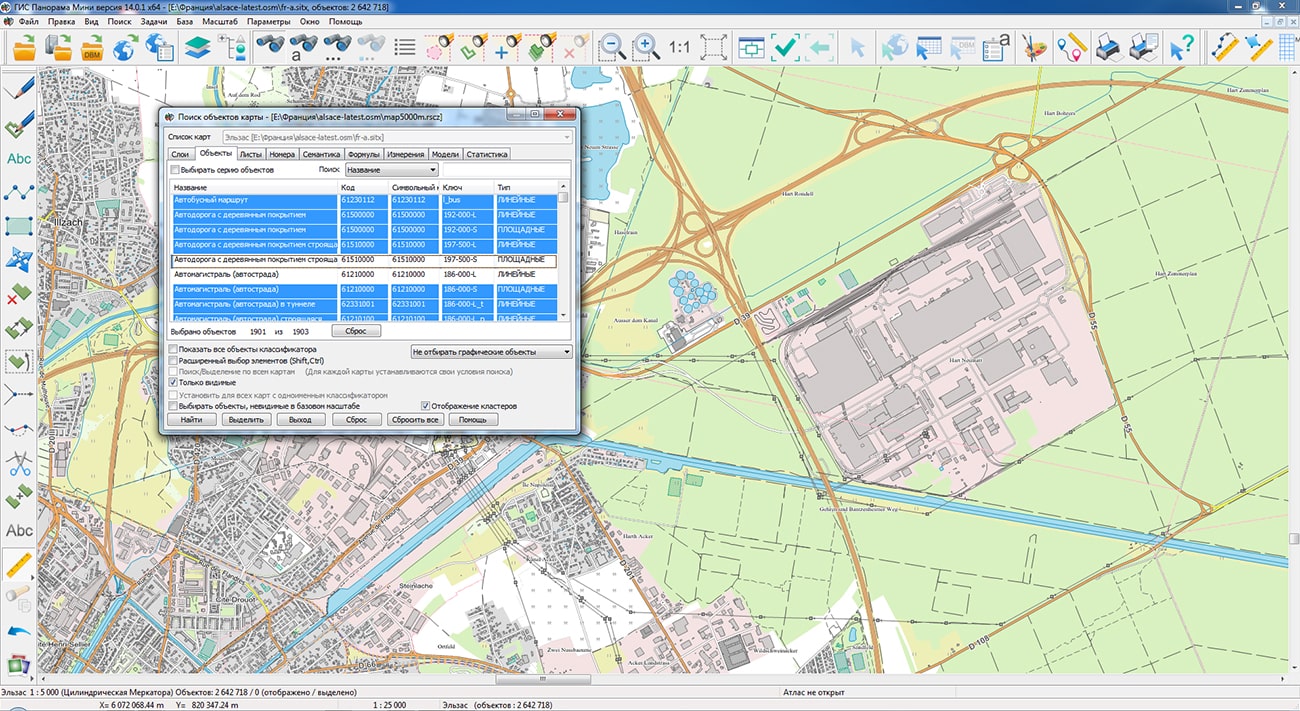
Geoportal has been supplemented with a map of the Alsace region (France), formed according to OpenStreetMap data. Source data was obtained from website. To work with the map, you can use the program or other software products of KB "Panorama".
The map was led to the modernised classifier of large-scale plans of scale 1: 5 000 (map5000m). Publishing of updates in bank of spatial data is made by using the program of . Publishing contents of bank of spatial data on the geoportal and data access for downloading are implemented by means of .
Free maps on the basis of OpenStreetMap data are available for download on the page "Digital maps".


In KB "Panorama" the has been developed. In the new version there are improved the tools for connecting remote video cameras, viewing photo and video data, editing spatial databases in information systems, automating the construction and updating of diagrams for territory analysis, processing matrixes of heights and quality control of digital vector maps.
In the task, the new modes have been added for work with streaming video and photos with a geolocation. The mode allows you to select an object on the map and establish a connection to the camera by means of dialog the "Setting up and viewing a connection to a video camera". After connecting to the camera, a window for viewing the video stream opens. If the selected object already has an url-link to the video stream, then the viewing window will be displayed immediately. The "List of photo and video data" mode allows you to view all objects on the map that have links to photo- and video data. In the dialog, you can go to these objects on the map, open the windows for viewing with displaying photo- and video data. For objects-cameras a setting connection to the camera is provided. The list of photos can be unloaded into a CSV file, which will contain the name of the photos, the path to the data and information from the EXIF tag.
Possibility has been added when updating multilayer cartographical representations of data. Objects of a digital map that displays the state of a spatial database are stored in various tables with their own sets of attributes. Objects from different tables can be displayed by conventional symbols from one classifier containing the corresponding layers and types of symbols. Database tables do not contain metadata that restricts recording the new objects from "alien" layer. The operator should choose a layer on which the object will be put from a large list, which slows down the work and introduces errors. To automatically determine the table to be updated, the ability to set filters by layers, objects, and a set of characteristics has been added into the settings of connected databases. Thus, since such a map is physically a table in the database, the possibility of writing alien objects into this table is limited. For example, into a table intended for storing the spatial layer "Routes of passenger transport" it is impossible to write down objects corresponding to the layers "Objects of cultural heritage", "Health institutions". The filter specified for the *.dbm map, which allows recording only areal objects with classification codes corresponding to the "Routes of passenger transport" layer, will not allow recording other objects into this map.
When *.dbm maps are opened together (for example, as part of an *.mpt project) that have the filters, described above, they are combined into logical groups, within which objects can be automatically redistributed upon recording. To combine maps into a group, the determining factor is the opening of data from the same database using the same classifier of conventional symbols. There can be several logical groups in the context of shared maps. Automatic redistribution of objects is performed only within a group. When a new object is saved onto a map with the specified filter, a suitable map will be automatically selected for it from among those that are jointly opened with the current map and included in the same group. If there is no matching map, the object will not be saved. When saving an existing object, if its classification code has been changed and the new code does not fall under the filter conditions of the current map, a suitable map will also be automatically selected for it. In the presence of a suitable map, the object will be saved onto it, and deleted from the source map. If there is no map suitable for the new classification code of the object, the changes will not be saved, and an error will be generated during saving. Automatic redistribution of objects works both when saving an object after it has been created/modified using the object editor, and at operations of a streaming insert of objects (Ctrl+C) or recoding (changing a symbol) of one object or group.
There are added the new types of programmable signs for . The description of diagrams includes a list of codes of semantics corresponding to sectors of the diagram. Each semantics has its own sector display parameters (color of filling, contour color, filling with shading and others). For a pie diagram, the parameters of the contour line and the size of the diagram radius in mm are set. The sector size will correspond to the share of the semantic value in the sum of the values of all semantics (for example: the number of residents, the percentage of those who voted for different parties, the area of different types of premises in the building, and so on). For a bar diagram, the maximum width and maximum height of the diagram are set. The real width will be proportional to the number of filled object semantics from the number of semantics in the diagram description. The real height will be proportional to the value of the maximum share of the value of the semantics to the sum of the values of all semantics. Diagram scalability and limits for increasing and decreasing its size are customized in the object parameters in the RSC classifier. To the right of the diagram, its legend is displayed. The texts of the lines for signing the sectors are taken from the names of the semantics, excluding the repeating part of the names. For example, if the semantics are called Number of inhabitants under 20 years old, Number of inhabitants from 20 to 40 years old, then the legend will contain the following lines: up to 20 years old, from 20 to 40 years old, and so on. Parameters of the text font are set in the symbol description. Drawing of a new type of symbols can be automated through the task "Creation of titles" in the "Combined text" mode. Pie diagrams will be created for selected objects with automatic copying of their semantics and establishing a logical connection to track changes in semantics and rebuild the diagram. The conventional symbol the Pie diagram is shown in the data example on the map \Data\shape.
The dialog for has been improved: the choice of a translucent line type (Line - color glass) and the setting for shift of hatching have been added. Use of imposing of two or more hatched views with different shifts of hatching allows to receive hatching of double, multicolor or other more complex views. Object type setting is performed in the map Classifier Editor or in the object selection dialog (on the "View" tab). The conventional symbol the Hatching with offset is shown in the data example on the map \Data\shape.
The task has been improved. The "Rejection of matrixes with elevations outside the specified range" mode has been added. The mode is intended for estimating the elevations of a set of united matrixes and determining the composition of data with reliable elevations. Matrixes with elevations outside the specified range are removed from the list of matrixes and moved into a separate directory. The "Summ elevation matrixes" task is intended for creating a file of matrix of elevations according to one or several open matrixes. Task execution in a mode of smoothing of elevations allows to eliminate sharp differences of elevations of the resulting surface.
The profiling mode "By triangulation" of the task has been improved. There are added a processing mode "By sheets" and the ability to select individual sheets of the region using the "Filter" button. The "By sheets" mode does not detect erroneous elevations differences between objects of different sheets, but it is performed 5-6 times faster than processing in the region, since triangulation is built for each sheet separately with a smaller number of edges (profiles). For the processing mode in the region, the issuance of unnecessary messages caused by the passage of profiles through the areas of sheets absence in the case of a non-rectangular form of region has been eliminated. Processing time indicator "Time (used/remain)" has been added. For a flat terrain with a large number of elevations and a small number of isolines, the "By triangulation" profiling mode eliminates misses that are possible when searching for heights in horizontal and vertical directions, which reduces the number of uninformative messages and facilitates the analysis of control results.
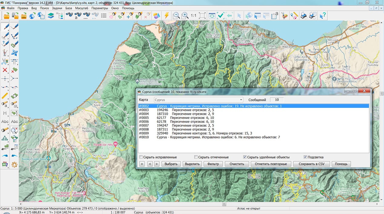
The task of has been improved. In the mode of control of self-crossings and location of subobjects, additional processing has been added: search and removal of matching fragments of the contours of linear objects, control and correction of flags for the occurrence of contours of multipolygons. The task is started via the main menu: Tools - Run Applications - Check of vector map quality.
The procedure for has been improved: search and removal of shuttle and spiral self-crossings has been added, statistics output on corrected and uncorrected errors has been added into the message log (Map Editor - View map control log). The procedure for correcting the metric is started through the main menu: Tools - Processing map by scenario - Correction of objects metrics.
The new version of the program is available for download in the section.


Geoportal has been supplemented with a map of the Auvergne region (France), formed according to OpenStreetMap data. Source data was obtained from website. To work with the map, you can use the program or other software products of KB "Panorama".
The map was led to the modernised classifier of large-scale plans of scale 1: 5 000 (map5000m). Publishing of updates in bank of spatial data is made by using the program of . Publishing contents of bank of spatial data on the geoportal and data access for downloading are implemented by means of .
Free maps on the basis of OpenStreetMap data are available for download on the page "Digital maps".


Ph.: +7 (495) 739-0245, +7 (925) 221-1603
www.gisinfo.ru | panorama@gisinfo.ru
105005, Russia, Moscow, Baumanskaya Street 7, building 1, office 229 (m. Baumanskaya)
Copyright © Panorama Group 1991 - 2024


 Mobile version
 Full version