Copyright © Panorama Group 1991 - 2024

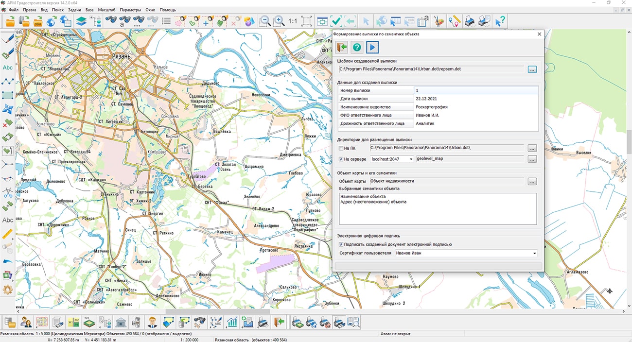
In KB "Panorama" the version 14.2.0 has been developed. To improve work efficiency and increase the speed of business processes, many users are switching to electronic document management using an electronic digital signature (EDS). In the new version of the program, a mode has been developed for and the extracts about objects of land management, real estate and infrastructure according to the semantics of map objects signed with an EDS. An extract is created based on a document template. If necessary, you can create your own templates using markers to insert values, such as the extract's number, extract's date, department name, and others.
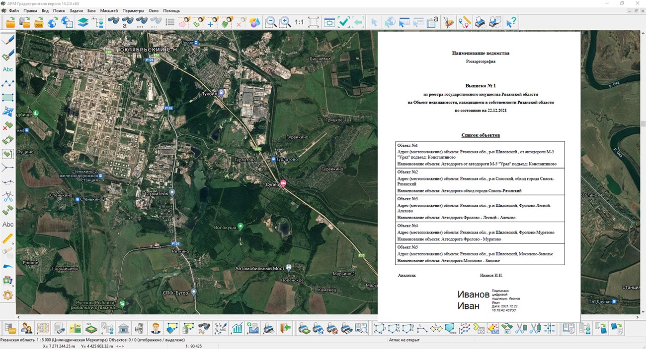
The extract is formed in PDF format and can be saved on a local disk or in a folder on the . Provides automatic linking of documents to a digital map by files of electronic copies of documents and the address of the object. To view extracts on the server, use the mode. The mode also allows you to export extracts to a local computer.
"Workstation of urban planner" is intended for use by local governments, individuals and legal entities for the implementation of cadastral, investment and other economic activities, land management. The program allows you to accumulate information about land plots, objects of real estate, premises and engineering networks. Collection, registration, updating, production and accounting of urban planning documents, materials, digital maps and schemes are provided. At the request of interested parties, urban planning information is provided.
The new version of the program is available for download in the Download section.


Geoportal has been supplemented with a map of the Kingdom of Sweden, formed according to OpenStreetMap data. Source data was obtained from website. To work with the map, you can use the program or other software products of KB "Panorama".
The map was led to the modernised classifier of large-scale plans of scale 1: 5 000 (map5000m). Publishing of updates in bank of spatial data is made by using the program of . Publishing contents of bank of spatial data on the geoportal and data access for downloading are implemented by means of .
Free maps on the basis of OpenStreetMap data are available for download on the page "Digital maps".


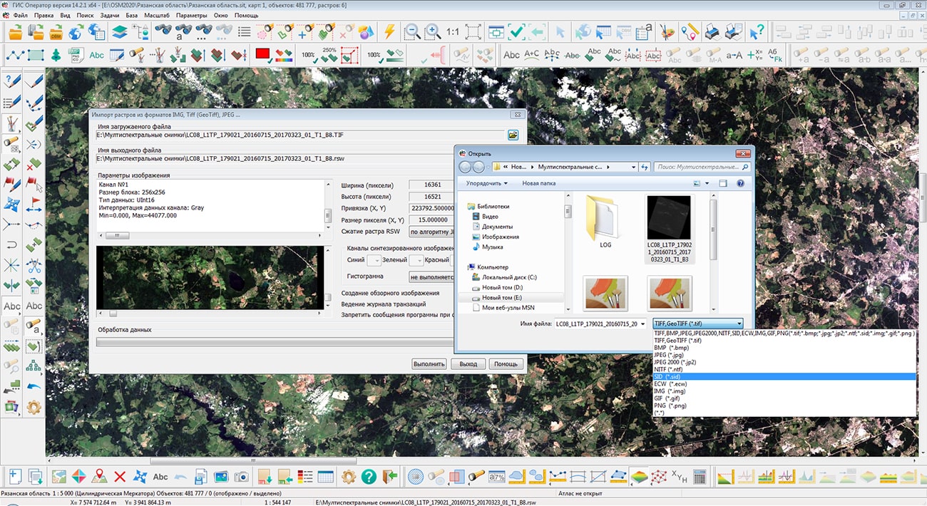
In KB "Panorama" the version 14.2 has been developed. In the new version of the program the import of graphic files of format MrSID (SID, NTF) and ERDAS (ECW, JP2) in the task has been added. Formats are applied to store compressed raster graphics. Packed huge raster images MrSID, such as air and satellite photos, can be quickly viewed in parts without necessity of unpacking the whole file.
Ability has been added to connected to the Internet. The location of cameras can be indicated on a map of the area, a plan of a city, a building, an industrial area, a three-dimensional model using various conventional symbols (objects). Objects can be movable if the camera is attached to a vehicle. In the semantics of objects, the url-link to the video stream or the ip-address of the camera is indicated. To view the video image, select the camera-object on the map. The program allows you to simultaneously view video in real time from different video sources. HTTP and RTSP data transfer protocols are supported. Customizing a connection to a video camera is performed on the "Semantics" bookmark, in the dialog. Integration of geodata with video streams allows you to create systems for monitoring the state of defensive positions, control systems for the movement of columns, security systems, and others.
In the "Map Editor" task on the "Graphic objects" panel, the mode has been improved. After selecting the link to the table file (csv, txt), display of data from this file has been added when creating and editing the view and table parameters. When creating each new object, you can select a link to your csv-file. The selected csv-file, if necessary, is copied into the \csv subdirectory of the map directory, on which the object of the "Table" type is created.
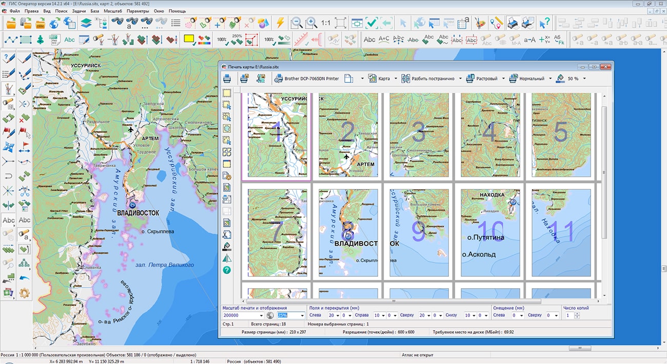
The task has been improved. Ability has been added to page-by-page save the printed areas to JPG, PNG, TIF and PDF graphic files. When saving in JPG, PNG, TIF formats the number of files corresponding to the number of selected pages is formed. The file name contains file name and page number, for example, noginsk_1.jpg. When saving to PDF, it is generated one multi-page document.
The applied task "Forecasting Emergencies" has been improved. In the new version of the task, spatial modeling of predicted emergency zones is performed in the UTM projection on the WSG-84 spheroid with with installation of the axial meridian at the epicenter of the accident, then the already prepared result is transformed to the map projection on which the user performed the calculation. This approach makes it possible to obtain the most realistic data on the ground by minimizing the errors in angular values and distances conditioned by the projection parameters of the original map. Thus into rectilinear segments of contours of objects of emergencies zones the additional points of the metrics are added for qualitative transformation of these segments and their transformation into arcs on a target map. These improvements do not apply to the computational problems of forecasting emergencies associated with a liquid spill, calculated from the matrix of heights. For these models, the calculation is carried out in the same projection that is set for the matrix of heights. The output of information onto the map based on the simulation results is supplemented by filling in the semantics of the affected areas, drawing the epicenters of accidents and signatures of the epicenters. The parameter "cloud transfer rate" has been added into the list of output parameters of the emergency model at a chemically hazardous object.
Together with specialists from the Ministry of Emergency Situations, the names of individual parameters were corrected in the forms for entering the initial data and displaying the modelling results. When displaying coordinates not in the coordinate system of the main document, for example, when adding a geoportal or when setting the Current projection parameters in the options menu, the <~> symbol is displayed next to the coordinates.
In the task "Map Computer", the mode has been improved. Ability has been added to select units for displaying the area of objects and record the area of intersection of objects into the specified semantics.
The new version of the program is available for download in the section.


Geoportal has been supplemented with a map of the region of Brittany (France), formed according to OpenStreetMap data. Source data was obtained from website. To work with the map, you can use the program or other software products of KB "Panorama".
The map was led to the modernised classifier of large-scale plans of scale 1: 5 000 (). Publishing of updates in bank of spatial data is made by using the program of . Publishing contents of bank of spatial data on the geoportal and data access for downloading are implemented by means of .
Free maps on the basis of OpenStreetMap data are available for download on the page .


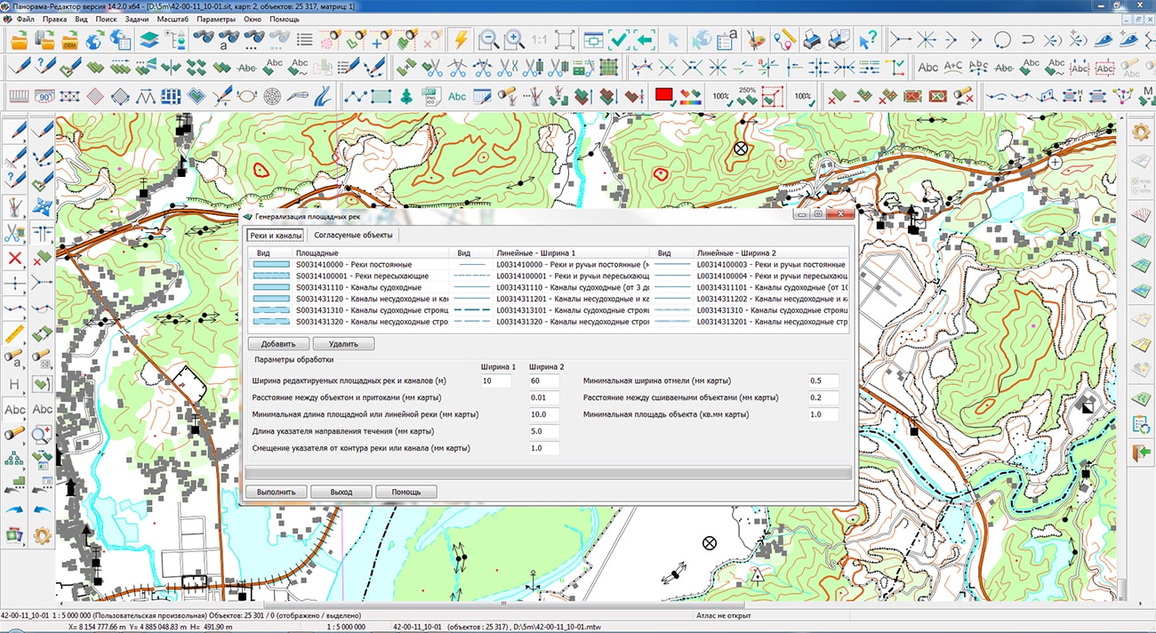
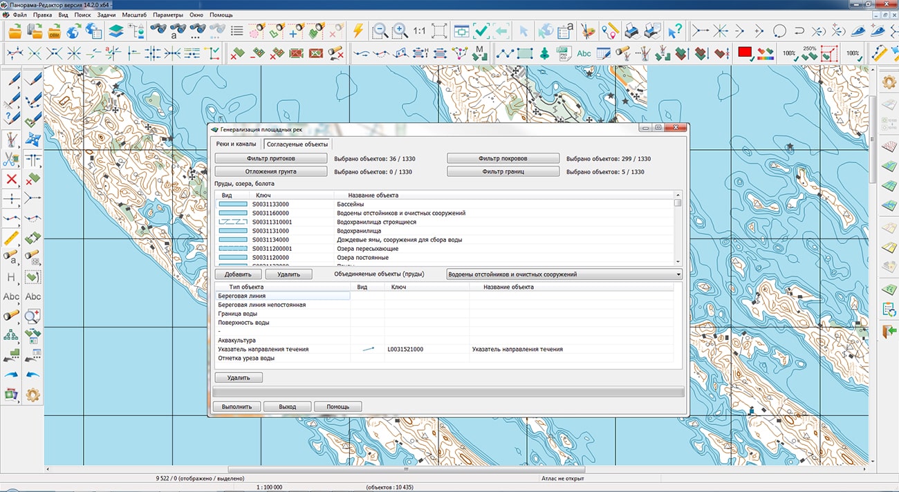
In KB "Panorama" the version 14.2.0 has been developed. In the new version the task of automated generalization of topographic maps has been improved. The mode has been developed. It is intended for simplification of a network of channels. Network simplification is achieved by disabling the visibility of channels of the lowered importance in base and smaller scales of a map. Degree of the importance of the channel is defined by channel type, length and character of its location relative to other channels and the rivers. In this task, two categories of objects are considered: priority and excluded objects. Priority objects are objects whose visibility will not change. Rivers are such objects. Excluded objects are objects whose upper visibility limit will be lowered by 1 level relative to the base map scale. Channels are the such objects. Excluded objects can be transferred into a priority category in the following cases: the priority object adjoins the excluded one; the excluded object has length more the than specified minimum length (10 mm on a map), the excluded object adjoins a border.
, setting the visibility of linear rivers and roads have been improved. The algorithm for shifting and sampling buildings in areas with an increased density of buildings per unit area has been refined. There is added a special handling of buildings intersecting with road network objects.
The profiling mode "By triangulation" of the task has been improved. To speed up the control process, the processing algorithm has been optimized. Map objects are read once, each object is profiled by all triangulation edges. The execution time of the control according to the new algorithm is reduced by 3-5 times. For a flat terrain with a large number of elevations and a small number of isolines, the "By triangulation" profiling mode eliminates misses that are possible when searching for heights in horizontal and vertical directions, which reduces the number of uninformative messages and facilitates the analysis of control results. The vertices of triangulation are: a point object (elevation, GGS point, mark of water edge), a point of the metric of an areal object with an absolute height (lake, reservoir), a point of the contour line's metric.
The task ("Subobjects" mode) has been improved - the ability to unite linear subobjects with a common point has been added, provided that the subobjects are located at a distance from each other which is not exceeding the Matching tolerance. The tolerance setting is done in the dialog, by default the tolerance is 0.1 mm on the map. As a result of the operation, new subobjects with the metric of the united contours are created, or points of the subobject's metric are added to the main object, provided that the conditions are met. Possibility of interpolation of the metrics of linear and polygon objects with the specified step has been added. Procedure is intended for addition into the metrics of objects of new points with a given step without change of the general geometry of object. It allows to transform correctly, for example, contours of objects of small-scale maps from cylindrical projections to conic and azimuthal projections.
The task has been improved. The new type of control the "Control of correspondence of relief objects and height matrixes" has been added. In the presence of a matrix of heights for each point of object with 3D metric a check of correspondence of value of the third coordinate of a point of the metrics and value of height in a matrix is carried out. If the third coordinate in the object metric is absent, then the correspondence of the value "Absolute height" of the object semantics and value of height in a matrix is checked.
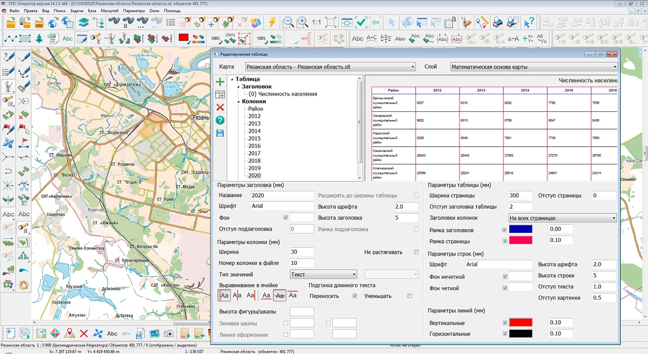
The functionality of the has been expanded. On the panel "Graphic objects" the mode "Create table" has been added for creating a graphical object of the "Table" type. On panel "Autoshapes" the mode "Fairway creation" for the areal and linear objects has been added. On the panel "Cut and combine" the mode "Dissection of a linear object by a linear" has been added. Processing of both open and closed contours is supported. The processing of the sections of the edited object that are inside the dissecting object is performed in three modes: saving without changing the code, deleting sections, recording with changing the code.
The mode by the metric coordinates entered from the keyboard has been improved. To speed up the work, the ability to copy and paste coordinate values using the clipboard has been expanded (key combination Ctrl+C, Ctrl+V).
The modes of creating a linear and areal object have been improved using the new parameter "Snap at shortest distance", which is activated when the corresponding item of the context menu is selected or by pressing the "hot" key "W".
In modes "New Image" and "Copy of object with change in image" there is added the possibility of creation of raster signs by each point of the metrics of the selected object or a group of selected objects. Result of executing the operation of recoding is the set of point objects, the coordinates of the metric of which correspond to the metric of the selected object.
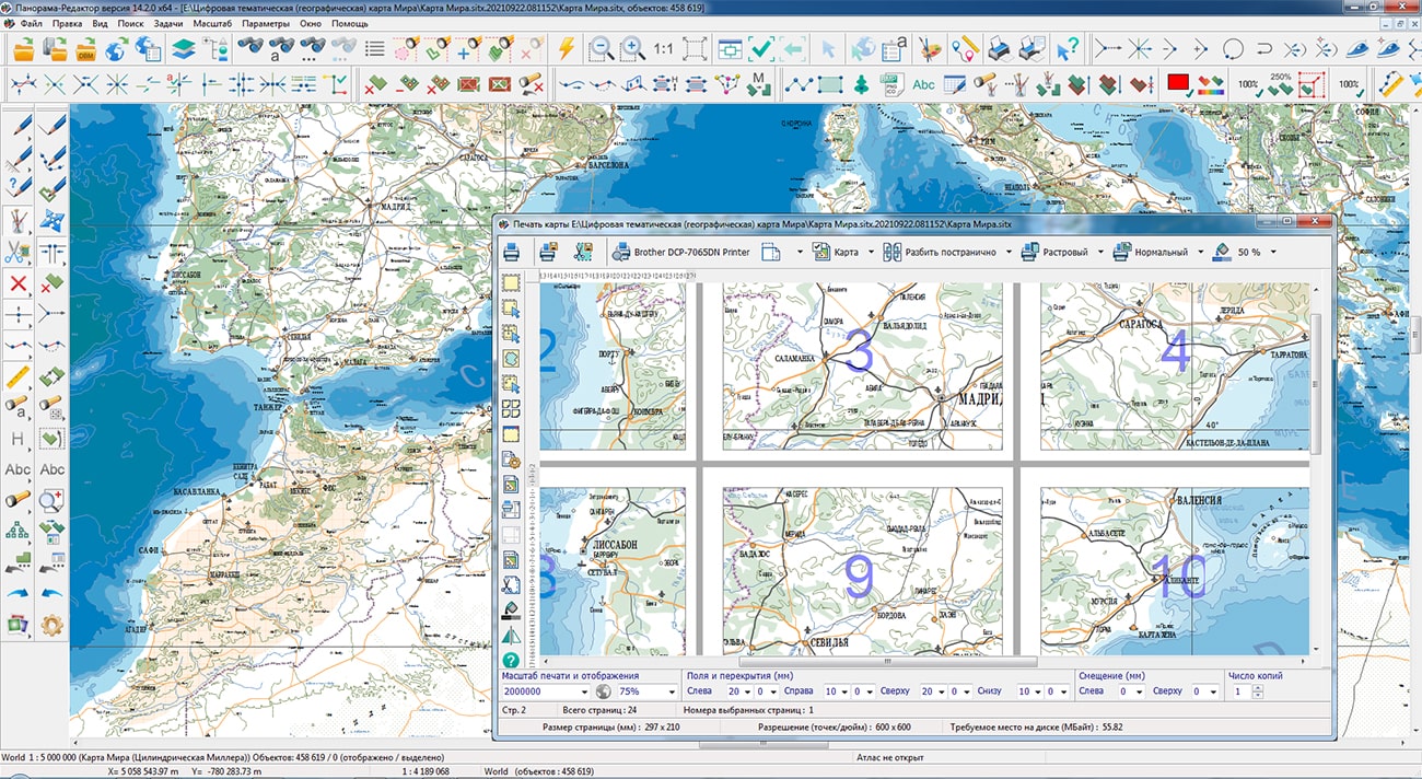
The task has been improved. Ability has been added to page-by-page save the printed areas to JPG, PNG, TIF and PDF graphic files. When saving in JPG, PNG, TIF formats the number of files corresponding to the number of selected pages is formed. The file name contains file name and page number, for example, noginsk_1.jpg. When saving to PDF, it is generated one multi-page document.
The functionality of task the , which is a part of the Geodesy editor, has been expanded. There are added the tools for generating design templates, for example, corner legends, with the ability to use them when creating new documents. A copying of the generated document into JPG, PNG, TIF, PDF formats have been added. A new "Move" mode has been added, with help of which it is possible not only to move objects, but also to carry out their deleting, a snap of metric points to grid knots, to operate order of displaying objects and to change a font of text. Manual input of the dimensions of created objects in a special pop-up window has been implemented. There are added the tools for editing object nodes: insert, delete, move. Interface for quick, dialog-free input of dimensions has been implemented when creating and editing objects.
In the dialog, the ability has been implemented for adding and editing semantics of type the "Link to the file folder". Value of semantics is the name of directory, which contains many files of different formats and folders. By double click by a mouse on the chosen file, the corresponding program of recognizing and processing the file is started. When referring to documents, tables and graphic images, the contents of the file are displayed, when referring to spatial data, the dataset is opened in a separate GIS window.
The task has been improved. There is added a support for the geoportal of the Russian Federal Geological Fund - Objects of accounting for the state balance of mineral reserves, demonstrating the presence of minerals. The geoportal includes 3 layers: Hydrocarbon raw materials, Solid fuel minerals, Common minerals. Support for the Rosreestr geoportal has been improved. The speed of displaying data from geoportals has been increased due to requests for the availability of data for selected territories. Display of vector information has been improved, captions have been added and "outliers" in vector tiles have been corrected.
The task " has been improved. Import of rasters of format MrSID (SID, JPEG2000, NTF, ECW) has been added. The MrSID format is used to compress raster graphics. By means of this format, packed huge raster images such as aerial photography and satellite photos can be quickly viewed piecemeal without the need to unpack the entire file.
The new version of the program is available for download in the Download section.


Ph.: +7 (495) 739-0245, +7 (925) 221-1603
www.gisinfo.ru | panorama@gisinfo.ru
105005, Russia, Moscow, Baumanskaya Street 7, building 1, office 229 (m. Baumanskaya)
Copyright © Panorama Group 1991 - 2024


 Mobile version
 Full version