Copyright © Panorama Group 1991 - 2024

Specialists of KB "Panorama" have prepared a video lesson on using the mode. This task is intended to check the structural integrity of digital data, the completeness and quality of the metric and semantic description of objects, and to perform automatic correction of detected errors.
The task "Check of vector map quality" can work in two modes: control of the data and editing of the data. In dialog "Checking type" the following groups of check are specified:
- structural control, which is performed always and for all map objects and can never be disabled;
- control of the map passport;
- control of the objects metrics;
- control of the objects semantics;
- topological control (coordination control) of data.
In each group of checking types, except for structural control, it is possible to set or deactivate the checking types specified in the corresponding list. You can disable/enable each specific type of check. The list of specified types of checking and their parameters forms a temporary file of the scheme of control which is relevant during the current session of the program of control.
When the control program is called for the first time, the types of checking and their parameters are set in accordance with the Default.cxml schema from the program directory. This schema contains the types of control and their parameters that are set by default. Error messages for each map are recorded into the log and into the report on execution of the map quality control. Errors can be viewed in the control log and printed as a report document. The HTML report document is saved in the map directory. Viewing the results of control is carried out in the mode "View map control log" in the . You can switch to viewing the results of control by means of the "Protocol" key.
You can get acquainted with the training materials in the "Video lessons" section.


In KB "Panorama" the version 14.0.3 has been developed. In the new version of the program, the display of sea maps has been refined, the tools for creating and updating working maps of the operational situation and the design of special maps have been updated. The display of sea maps of S57/S52 standards has been improved. In the s57navy.rsc classifier for attributes that have a list of classified values (Attribute type: L - CATAIR, CATACH, ... TECSOU), property the "Repeat allowed" is set. There is refined a display of depth marks taking into account safety contours and taking into account depths on drying surfaces.
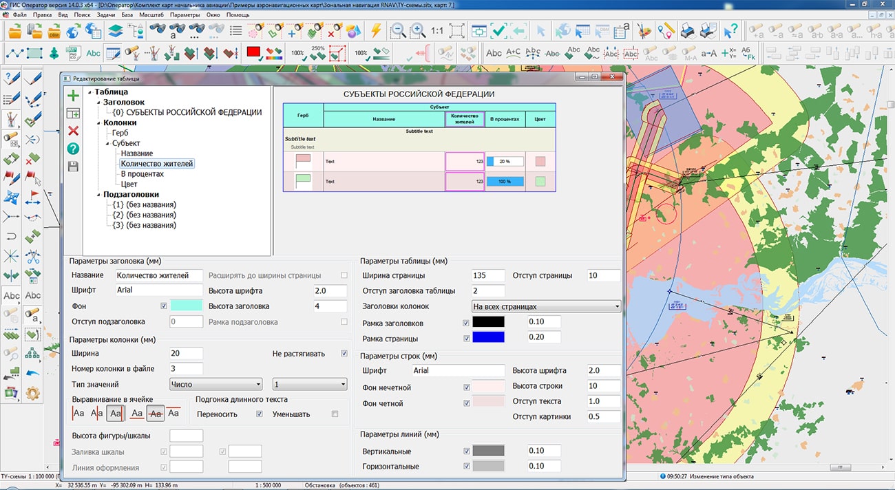
To display tables with data of operational situation on the map, a new graphic symbol has been developed. This symbol is a point object that has a link to a CSV file in semantics and a conventional symbol of the table type. The graphic parameters of the table are customized in the semantics of the object, in the RSC classifier or in the graphic parameters of the object. The table cell allows to place the text, the numerical data, pictures (in PNG, JPG, BMP format), colored figures and the percentage scales. The table can consist of one or more pages. Table parameters are customized in the dialog. A layer with tables can be opened on top of any other data - spatial databases, geoportals, remote sensing data. The map, together with CSV files and background data, can be packed into one file of SITZ/MAPZ/MPTZ formats. The map with the put tables will have one view in desktop, mobile, web-applications on any platforms, when locally placed or on the and when printing.
In the " task, the mode by the metric coordinates entered from the keyboard has been improved. To speed up the work, the ability to copy and paste coordinate values using the clipboard has been expanded (key combination Ctrl+C, Ctrl+V). Copying and pasting data is supported both in a separate field and in a selected range of table cells. The modes of creating a linear and areal object have been improved using the new parameter "Snap at shortest distance", which is activated when the corresponding item of the context menu is selected or by pressing the "hot" key "W".
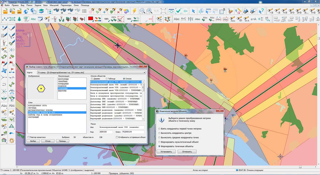
For the mode there is added the possibility of creation of dot signs by each point of the metrics of the selected object or a group of selected objects. A new image of object is assigned using the dialog "Select object type from the classifier" or by pressing the hotkey "E". Result of executing the operation of recoding is the set of point objects, the coordinates of the metric of which correspond to the metric of the selected object. After completing the assignment of a new symbol in the "New Image" mode, the original object is deleted.
On the panel the mode has been added for creating a graphical object of the "Table" type. The graphical view of the object makes it possible to immediately create and draw the desired table onto the map, without adding it into the classifier. This method is relevant if the created table is unique for a specific object/territory on the map.
In a mode of creation of objects the possibility of changing the settings of the title has been added during object creation. Title customizing is carried out in dialog of selecting a font which is started by means of the contextual menu item to Set font parameters.The new font values are stored in the object semantics the Coordinate label.
In the mode there is added a support for calculating the coordinates of a metric point using the specified initial coordinates of the point, azimuth and distance to the next point.
In the dialog, the ability has been implemented for adding and editing semantics of type the "Link to the file folder". Value of semantics is the name of directory, which contains many files of different formats and folders. When accessing the filled semantics "Link to the file folder", a list of files contained in the root folder and subfolders is automatically generated. By double click by a mouse on the chosen file, the corresponding program of recognizing and processing the file is started. When referring to documents, tables and graphic images, the contents of the file are displayed, when referring to spatial data, the dataset is opened in a separate GIS window.The folder with documents can be compressed into a ZIP file, and the object can be assigned the semantics of the "Link to a file" type. Actions with documents will be the same as when linking to a folder. When packing maps into MAPZ, SITZ, MPTZ formats, documents referenced from the semantics of type the "Link to the file folder" will also be packed into one data set, unlike semantics the "Link to a file".
On the bookmark, the "Select similar objects" and "Select objects by semantics" items have been added to the context menu. When selecting objects similar to the selected one, a coincidence is checked in terms of the layer, character of localization, the object code and the coincidence of the value of the current semantics or the semantics selected on the bookmark. When selecting objects by semantics the value coincidence of only current semantics or marked semantics is checked.
In the bookmark, the "Display order" item has been added into the context menu for selecting the "Above everyone", "Below all", "Normal" property, which affects the position of an object relative to other objects. When the "Normal" property is set, the display order of the object is determined in the classifier by its layer, type of conventional symbol and localization. Into the context menu the "Save metric coordinates to EPSG:3857" item has been added, intended for saving the object metric in GeoJson format in the Mercator projection on the WGS-84 sphere. The received file can be used for addition of objects on the Public cadastral map. In the "Metric" bookmark, a fast copying into a clipboard of all coordinates of the metrics using the Ctrl+A key combination has been implemented for the further use of the copied data, for example, for their placing in the mode of creation of object by coordinates entered from the keyboard.
Into dialog of the possibility of selecting a mode of creating a title for a multipolygon has been added. When the "To sign all objects included in the multipolygon" option is enabled, the title is formed for each contour that belongs to the multipolygon and is created in accordance with the dialog settings
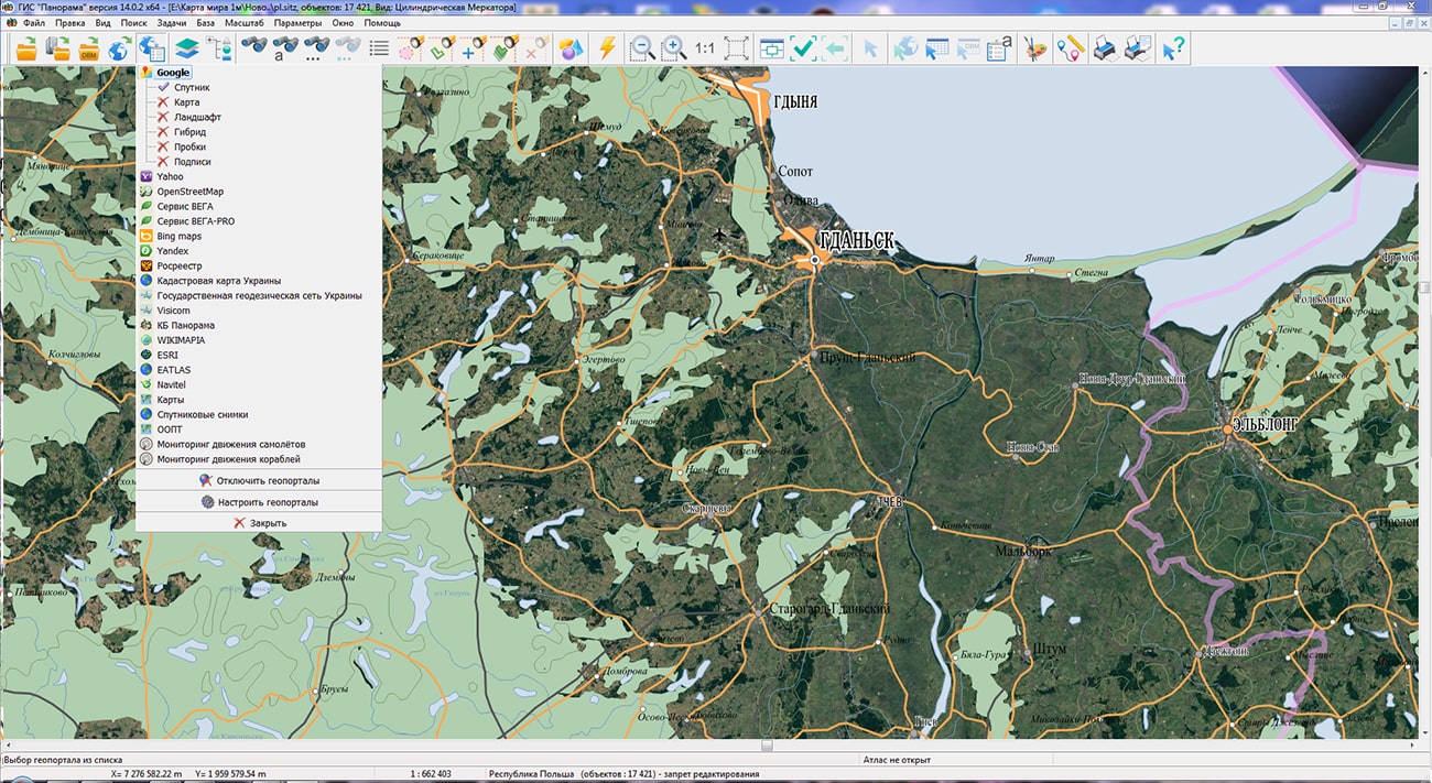
The task has been improved. There is added a support for the geoportal of the Russian Federal Geological Fund - Objects of accounting for the state balance of mineral reserves, demonstrating the presence of minerals. The geoportal includes 3 layers: Hydrocarbon raw materials, Solid fuel minerals, Common minerals. Improved support for the Rosreestr geoportal. The speed of displaying data from geoportals has been increased due to requests for the availability of data for selected territories. Display of vector information has been improved, captions have been added.
The task has been improved. On the "Maps" bookmark, the "Paste selected objects" menu item has been added into the context menu. This mode allows you to paste objects previously copied to the clipboard onto one or several selected maps in the tree.
The task has been improved. On the "Matrix" bookmark the call of the mode has been added. Optimization of the matrix of qualities is performed to reduce the file size, as well as to update reduced copies (tiles) of the matrix for different display scales. Reducing the file size is achieved by cutting the image by the specified frame. A call of the new mode has been added. The mode is intended for changing the binding of matrixes of height, layers and qualities of the document onto a specified value in meters. Changing the location is carried out both for one and for all matrixes of the document.
The task has been improved. On the page there is added the information about execution of summary of the sides of a map sheet with adjacent sheets. The summary of adjacent map sheets is a coordination of areal and linear objects of adjacent sheets, the contours of which go onto the sheet frames. Objects of adjacent sheets are considered coordinated in case of conformity of the points going onto the frame, and absence of contradictions of semantic characteristics. On the "Metadata" page, the list of metadata saved into the ".meta.xml" file has been expanded. There is added a recording an information about the restrictions on the use of the dataset: information about the agreement (contract), under which the dataset was created, containing restrictions on the distribution and use of data. Improvements were made in order to ensure the maintenance of federal and regional collections of spatial data and the completeness of the metadata description.
The task has been improved. Legend and explication maps are created in a conditional coordinate system, which eliminates distortion when added to a map created in other projection. Into the menu the items were added "Show all objects" and "Display/Inform window". The mode "Show all objects" is intended for displaying all map objects without taking into account the range of objects visibility and the contents of the map display. The mode "Display/Inform window" is intended to enable or disable a pop-up message that informs the operator about the result of the action performed in the map window.
The new version of the program is available for download in the section.


In KB "Panorama" a digital geographic map of scale 1: 1 000 000 in format SXF onto territory of Republic of Poland has been prepared. As a source for preparation of the map the obtained from the information from the site has served. The map contains information on the number of inhabitants for cities and the name of settlements in Russian. As additional materials the World map of scale 1: 5 000 000 and data were used.
The map was led to the classifier of geographic maps of scale 1: 1 000 000 (). It can be used for a general assessment of the area and the study of natural conditions, to ensure the educational process, as a basis for the creation of geographic maps of a smaller scale, thematic and special maps, and solving other tasks. The map is distributed free of charge under a free .
Digital geographic map of scale 1: 1 000 000 in SXF format is available for download on the page "Digital maps".


In KB "Panorama" the version 6.4.0 has been developed. The new version adds a set of tools for quality control of digital vector maps: Quality control of digital maps and plans, Control of report of nomenclature sheets of digital maps, Control of the absence of classified information on digital topographic maps of open use. To perform control, it is necessary to select the checked data sets by a filter in the metadata table or by spatial request and select the type of control. Detailed control protocols are stored in the Databank of Digital Maps and remote sensing data and are recorded into the metadata table of the checked sets along with the number of found errors. In the future, this information can be used to analyze data quality and generate reporting documents.
Quality control of digital maps provides checking the correctness of filling in passport data (metadata), coordinates and attributes for several dozen parameters, for example: control of self-intersection, entry of subobjects, metric's duplication, the presence of discontinuities of the same type of objects, the presence of nodal points, coordination of adjacent objects, control of the direction of digitization, coordination of water levels and objects of hydrography, control of water courses and others. The control parameters can be changed or supplemented by means of the taking into account the used digital classifiers and the requirements for data quality. You can learn more about the set of data control tools in the .
The view of the control report in html format is controlled using an html-template. Report templates can be changed taking into account the requirements of structural divisions of enterprises of geodesy and cartography, or enterprises that use spatial data in their activities. All operations of the operator of the Data Bank are recorded in the log of user actions.
Checking a coordination of adjacent nomenclature sheets includes: searching for objects going on frames of the adjacent sheets, checking the matching of metrics and attributes of objects of adjacent sheets. Control of presence of data prohibited for display allows you to check digital topographic maps of open use and digital plans of cities for compliance with the requirements of regulatory documents (Decree of the Government of the Russian Federation of 09/04/1995 N 870, as amended on 03/18/2016 N 214). It includes control of the absence of objects prohibited for display and control of the absence of characteristics that are prohibited for display. The list of types of control of the absence of closed information is contained in the control scheme, which can be changed or supplemented by means of the GIS "Panorama".
Data security is ensured by the differentiation of access rights based on security tools that are part of the operating system. Basic authentication, digest authentication, system authentication (via web server), and domain (Kerberos or Active Directory) are supported. The complex is adapted to work on a wide range of operating systems (Astra Linux SE, ALT Linux, Elbrus, Ubuntu, CentOS, MS Windows and others) and architectures (Intel, Elbrus, Baikal).
The complex of conducting a databank of digital maps and remote sensing data of the earth is registered in the register of domestic software under number 1862.
The databank of digital maps and remote sensing data is the basis for building infrastructure of spatial data at the federal, regional and municipal levels, in corporate information systems. Within the framework of a single geoinformation space, the Data Bank of digital maps and remote sensing data realises gathering, storage, quality control, search and delivery of the spatial data in exchange formats. The spatial data selected by means of the program can be placed for the multiuser access on the and be published according to the international standards OGC WFS, WFS-T, WMS, WMTS, WCS on application server the GIS WebService SE. Users can access data from both a thin client (by means of ) and from desktop applications (GIS "Panorama", GIS "Operator"). The databank of digital maps and remote sensing data provides construction of cloud warehouse of spatial data, provision of access to these data, the automated formation and updating of geocovers.
The current state of spatial data is displayed by means of maps-schemes that are maintained for each type of stored data: vector maps, remote sensing data, elevation matrixes and terrain models. It provides remote placing the sets of spatial data into file warehouse, keeping versions of stored sets, updating maps-schemes of data availability, the automated collection and formation of metadata, and the formation and updating of geocovers. Automated collection and formation of metadata is performed according to the standards of ISO 19115: 2003, Geographic information - Metadata and ISO/TS 19139, Geographic information - Metadata - XML schema implementation. The reduced copies of data images are automatically formed, checksum of files and completeness of data sets are checked. Placement of spatial data into file storage is performed with integrity check, control of data structure and content. The results of the work are recorded and entered into the metadata base. Automatic backup of metadata and spatial data storage with integrity control and data recovery has been provided. Multilingual interface is supported.
The portal presents the possibilities of organizing storage, accounting and and issuance of vector maps, remote sensing data, DEMs and terrain models. The portal contains vector maps in SXF format, generated on the basis of data from open sources (OpenStreetMap, VMap0). The spatial data includes maps of: subjects of the Russian Federation, countries and cities of the near and far abroad. In total, over 240 vector maps and 6700 matrix data with a total volume of 56 GB. Specialists of KB "Panorama" weekly update and refresh the content of the information on the portal. All published data is distributed free of charge under a free license.
The new version of the program is available for download on the page.


Specialists of KB "Panorama" have prepared a video lesson of using the mode . The task under consideration is intended for loading vector data from the OSM exchange format. Users of the , when choosing the source map, have access to a choice of OSM, MAP, SIT, SITX files.
The full technological scheme of importing the data fromOSM format is carried out in stages. All modes of the technological scheme are independent. You can select all, one or several modes for processing. The only strict limitation is obligatory execution of "Import" when you select an OSM file as the source map. In other cases it is possible to execute any set of processes (except "Import"). For example, decoding and correction or formation of labels and their generalisation. However, the OSM format does not provide for the storage of label objects, and labels are not generated during the conversion of data.
Formation of labels is carried out by means of the hidden call of procedure the "Automatic labels alignment" of the applications' group . Customizing the file of parameters of drawing labels is carried out by means of the specified procedure (start from the list of applications of GIS "Panorama"). Description of the parameters structure and the order of execution are described in the corresponding documentation and on-line help tools. The rules for drawing labels are written in the .ilb file. At program start by default it is offered to execute import by the map5000m.rscz classifier included into the installation kit and the files of parameters of recoding the map5000m.osm2map and map5000m.rsc.ilb corresponding to it.
You can get acquainted with the training materials in the "Video lessons" section.

Ph.: +7 (495) 739-0245, +7 (925) 221-1603
www.gisinfo.ru | panorama@gisinfo.ru
105005, Russia, Moscow, Baumanskaya Street 7, building 1, office 229 (m. Baumanskaya)
Copyright © Panorama Group 1991 - 2024


 Mobile version
 Full version