Copyright © Panorama Group 1991 - 2024

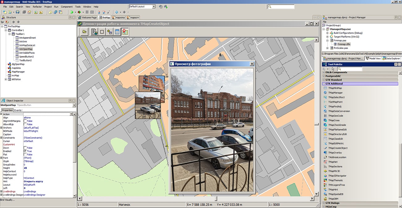
In KB "Panorama" the toolbox of version 14.0.2 has been developed for creating GIS applications in the environment of C++ Builder, Delphi Embarcadero. The new version includes tools for obtaining information about terrain objects using a combined technology for combining ground-based photographic materials with the results of remote sensing data. In the component for converting spatial data MapDataConversion there is added the function of loading photos in JPEG format containing GPS coordinates of the shooting location in EXIF tags. Typically, photographs taken with digital cameras and mobile phones equipped with a GPS receiver have such properties. Photos are loaded from the specified folder with photos. As a result, a service map will be added to the open document, containing point objects, for which semantics are automatically filled with a link to photo files. The service map is saved in the folder with the initial map and is added into the list of open maps. Photos on the map are displayed as icons (thumbnails). When the map is increased, the photos are also enlarged. The algorithm of an automatic clustering is applied for grouping of photos on a map at scaling. Densely located objects with photos are replaced with the first object in a cluster with indicating the number of photos in the given cell.
For viewing photos, the TMapManager component of map management has been improved, which allows to display a photo in a separate window when you click on an object. When programming, you can set the location and size of the window for viewing photos.
The GIS ToolKit consists of a set of visual components (supplied in source code) and API functions of the GIS core for direct access to spatial data. The toolkit is intended for the development of client-server and desktop 32-bit and 64-bit applications that require processing and visualization of spatial data. Spatial data can be located both at the workplace (direct access to data) and in a local network or the Internet (components of access to the or data exchange by international protocols are used).
The new version of the program is available for download on the page.


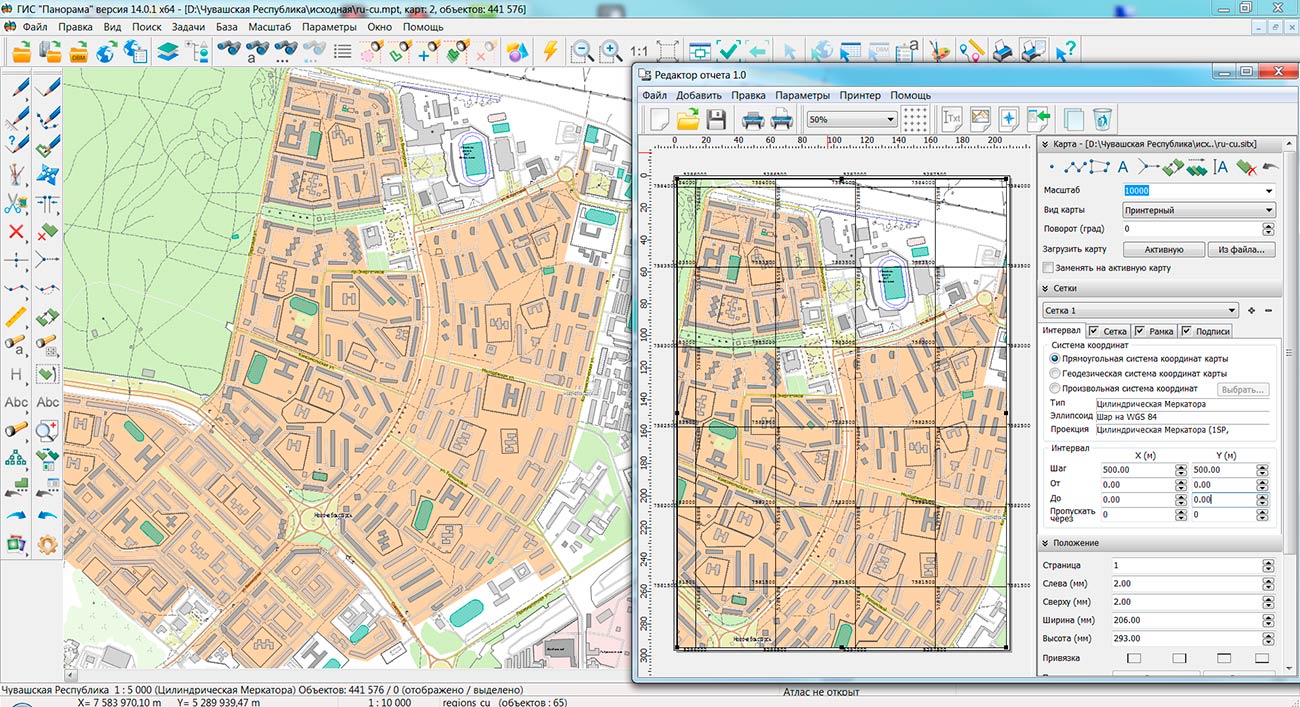
Specialists of KB "Panorama" prepared and placed the map of the Chuvash Republic on the geoportal . The map was formed using OpenStreetMap data, source data was obtained from website. To work with the map, you can use the program or other software products of KB "Panorama".
The map was led to the modernised classifier of large-scale plans of scale 1: 5 000 (map5000m) and was saved into a packed project (MPTZ). The MPTZ format project includes a digital map of the region's territory (country, subject of the federation, administrative region), a map of the administrative-territorial division of the region and a digital classifier. Publishing of updates in bank of spatial data is made by using the program of . Publishing contents of bank of spatial data on the geoportal and data access for downloading are implemented by means of .
Free maps on the basis of OpenStreetMap data are available for download on the page "Digital maps".


Specialists of KB "Panorama" have prepared a video lesson on creation of mathematical basis of the map. Users of the can independently create a rectangular and cartographic grid, as well as customize the display of these grids and other construction parameters.
In the training material a work with the tool is considered, which is available in the menu "Run Applications - Automatic creation of objects". The task is intended for creation of a mathematical basis for digital topographic maps of scale from 1:10 000 till 1:1 000 000 and for geographic maps of scale from 1:500 000 till 1:10 000 000. Most often, this tool is called to check the accuracy of placing raster images. When creating a mathematical basis for topographic maps, it is necessary that all the sheets of the region belong to the same six-degree zone.
You can get acquainted with the training materials in the "Video lessons" section.


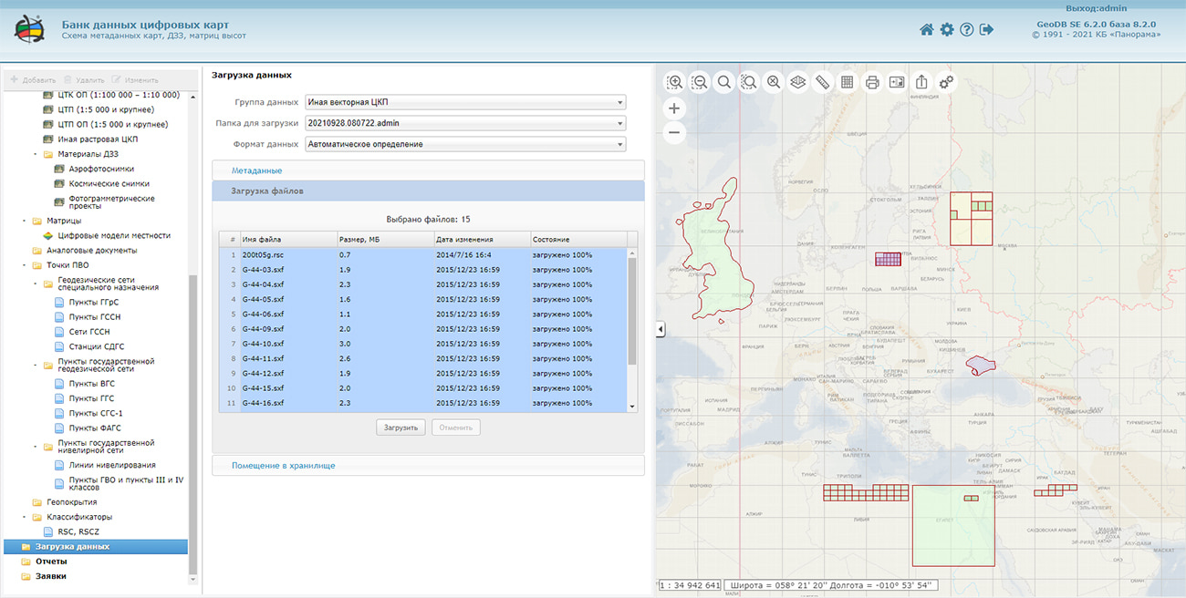
In KB "Panorama" the version 6.2.0 has been developed. For the joint work of divisions of enterprises that have funds of spatial data, there are added the tools of differentiating the access rights to certain categories of digital information about the terrain (maps, images, matrixes, geocovering, classifiers, geodetic points). Separate permissions for each category of data on viewing, editing, deleting, downloading and loading the data have been implemented. This makes it possible to organize separate and secure access to digital information for structural units of enterprises of geodesy and cartography, or enterprises that use spatial data in their activities.
Possibility has been added for the opening (starting) of a databank in a mode of loading of the data, formations of requests, reports or opening of a certain layer of data with metadata filtration. Having set the appropriate rights for each structural unit, they can start their work with a specific task. Access to the tasks of adjacent divisions for them will be closed. It provides additional protection of spatial data and speeds up the work process.
Convenient access to data processing logs is provided. Setting for the path to the log repository has been added. The log files are grouped into subfolders with date indicating.
Possibility of converting vector maps into SXF and SHP formats was implemented. The operator selects necessary data sets, builds a geocovering in the specified coordinate system, chooses a format of converting and a folder for export. When finished, a protocol with the results of converting is displayed. Each geocovering can be previewed in a separate window. If you have the appropriate permissions, you can work remotely with geocovering using desktop applications such as the or .
Data security is ensured by the differentiation of access rights based on security tools that are part of the operating system. Basic authentication, digest authentication, system authentication (via web server), and domain (Kerberos or Active Directory) are supported. The complex is adapted to work on a wide range of operating systems (Astra Linux SE, ALT Linux, Elbrus, Ubuntu, CentOS, MS Windows and others) and architectures (Intel, Elbrus).
The complex of conducting a databank of digital maps and remote sensing data of the earth is registered in the register of domestic software under number 1862.
The databank of digital maps and remote sensing data is the basis for building infrastructure of spatial data at the federal, regional and municipal levels, in corporate information systems. Within the framework of a single geoinformation space, the Data Bank of digital maps and remote sensing data realises gathering, storage, search and delivery of the spatial data in exchange formats. The spatial data selected by means of the program can be placed for the multiuser access on the and be published according to the international standards OGC WFS, WFS-T, WMS, WMTS, WCS on application server the . Users can access data from both a thin client (by means of ) and from desktop applications (GIS "Panorama", ). The databank of digital maps and remote sensing data provides construction of cloud warehouse of spatial data, provision of access to these data, the automated formation and updating of geocovers. The current state of spatial data is displayed by means of maps-schemes that are maintained for each type of stored data: vector maps, remote sensing data, elevation matrixes and terrain models. It provides remote placing the sets of spatial data into file warehouse, keeping versions of stored sets, updating maps-schemes of data availability, the automated collection and formation of metadata, and the formation and updating of geocovers. Automated collection and formation of metadata is performed according to the standards of ISO 19115: 2003, Geographic information - Metadata and ISO/TS 19139, Geographic information - Metadata - XML schema implementation. The reduced copies of data images are automatically formed, checksum of files and completeness of data sets are checked. Placement of spatial data into file storage is performed with integrity check, control of data structure and content. The results of the work are recorded and entered into the metadata base. Automatic backup of metadata and spatial data storage with integrity control and data recovery has been provided. Multilingual interface is supported.
The portal presents the possibilities of organizing storage, accounting and and issuance of vector maps, remote sensing data, DEMs and terrain models. The portal contains vector maps in SXF format, generated on the basis of data from open sources (OpenStreetMap, VMap0). The spatial data includes maps of: subjects of the Russian Federation, countries and cities of the near and far abroad. In total, over 240 vector maps and 6700 matrix data with a total volume of 56 GB. Specialists of KB "Panorama" weekly update and refresh the content of the information on the portal. All published data is distributed free of charge under a free license.
The new version of the program is available for download on the page.


Specialists of KB "Panorama" prepared and placed the map of the Ulyanovsk region on the geoportal . The map was formed using OpenStreetMap data, source data was obtained from website. To work with the map, you can use the program or other software products of KB "Panorama".
The map was led to the modernised classifier of large-scale plans of scale 1: 5 000 (map5000m) and was saved into a packed project (MPTZ). The MPTZ format project includes a digital map of the region's territory (country, subject of the federation, administrative region), a map of the administrative-territorial division of the region and a digital classifier. Publishing of updates in bank of spatial data is made by using the program of . Publishing contents of bank of spatial data on the geoportal and data access for downloading are implemented by means of .
Free maps on the basis of OpenStreetMap data are available for download on the page "Digital maps".


Ph.: +7 (495) 739-0245, +7 (925) 221-1603
www.gisinfo.ru | panorama@gisinfo.ru
105005, Russia, Moscow, Baumanskaya Street 7, building 1, office 229 (m. Baumanskaya)
Copyright © Panorama Group 1991 - 2024


 Mobile version
 Full version