Copyright © Panorama Group 1991 - 2024

In KB "Panorama" the professional vectorizer version 14.0.1 has been developed. In the new version in the task, the mode for creating objects the has been improved. There is added the ability to dynamically change the settings of the title, which is created onto the map next to the cursor. By means of the "Set font parameters" contextual menu item, the font editing dialog is called, in which you can change the color, height, name and other properties of the font. The new font values are stored in the object semantics the "Coordinate label". In the mode "Creating object by coordinates entered from the keyboard" there is added a support for calculating the coordinates of a metric point using the specified initial coordinates of the point, azimuth and distance to the next point. In the "Cut lists" mode, the algorithm for specified by one list from objects specified by another list has been improved. When processing large amounts of data (hundreds of thousands of processed objects with thousands of internal contours), the operation time was reduced from several hours to minutes. The mode can be used, for example, for cutting islands in water bodies, glades in vegetation and for other objects. Processed objects are checked for self-intersections and automatically corrected. The contours of the cut objects are automatically matched to the processed objects, which significantly reduces the amount of manual work.
In the task of , the ability to create arbitrary graphic labels not specified in the RSC classifier has been added. The choice of color, font, height, thickness and other parameters of the label is performed in the dialog, which is called by the button "Graphics". The location of the graphic label relative to the object being signed, filling and displaying the semantic characteristics is carried out according to the same algorithm as for the title from the map classifier. In the task "Control of label metrics" the ability has been added of processing the titles on the selected map or on all maps available for editing.
The task has been improved. On the "Sheet Metadata" page there is added the information about execution of summary of the sides of a map sheet with adjacent sheets. The summary of adjacent map sheets is a coordination of areal and linear objects of adjacent sheets, the contours of which go onto the sheet frames. Objects of adjacent sheets are considered coordinated in case of conformity of the points going onto the frame, and absence of contradictions of semantic characteristics. By default, the signs of sheet sides summary have the "Not installed" value. When matching two adjacent sheets for the corresponding side in the passport of the map, the value "Completed" is set. For maps with an arbitrary territory without division into nomenclature sheets, the values "Not required" are entered in the summary fields. On the "Metadata" page, the list of metadata saved into the ".meta.xml" file has been expanded. There is added a recording an information about the restrictions on the use of the dataset: information about the agreement (contract), under which the dataset was created, containing restrictions on the distribution and use of data. Improvements were made in order to ensure the maintenance of federal and regional collections of spatial data and the completeness of the metadata description.
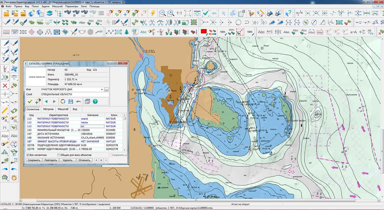
Displaying sea maps of S57/S52 standards has been improved. In the s57navy.rsc classifier for attributes that have a list of classified values (Attribute type: L - CATAIR, CATACH, ... TECSOU), property the "Repeat allowed" is set. When exporting and importing data, lists of attribute values (1,7,, 30) are written and read. For display of lists of values, into the the new operating symbol ' r ' (#113.r) has been added, which allows to form a line from the list of attribute values, separating them with a space. There is refined a display of depth marks taking into account safety contours and taking into account depths on drying surfaces.
The task has been improved. Legend and explication maps are created in a conditional coordinate system, which eliminates distortion when added to a map created in a different projection. Maps with tables of legends and explication are created with a coordinate reference to the northeast corner of the designed map, which allows adding maps without additional positioning. In the Legend formation mode, the functions "Divide into blocks", "Split Block", "Combine blocks" have been added.
The number of lines with conventional symbols of objects in a block can be changed. A block on the map is created in the form of a grouping of objects by semantics, which allows further general movement, deletion and other group operations.
Algorithms of data storage of type "a cloud of points" in data sets of format MTD have been improved. Packing of the data, taking into account the area of processed territory and the specified accuracy of storage, allows to reduce to 4 times the size of created MTD files which can be from several tens of Gigabytes to Terabytes. New algorithms allow to raise accuracy of terrain descriptions over a wider area.
In a problem is added a call of a new mode "Change of a binding of matrixes on dx/dy metres". The mode call is carried out on a bookmark of "Matrix" by means of the point of the contextual menu with the same name. The mode is intended for change of a binding of matrixes of heights, layers and qualities of the document on the set size in metres. Processed matrixes should be accessible on editing. Binding change is carried out both for one, and for all matrixes of the document.
In the task "Data list of map" a call of the new mode "Change of location of a matrix on dx/dy meters" has been added.The mode is called on the "Matrixes" bookmark using the same-named item of the context menu. The mode is intended for changing the binding of matrixes of height, layers and qualities of the document onto a specified value in meters. The processed matrixes must be available for editing. Changing the location is carried out both for one and for all matrixes of the document.
The "Display/Inform window" item has been added into the Options menu to enable or disable a pop-up message that informs the operator about the result of the action performed in the map window.
The new version of the program is available for download in the Download section.


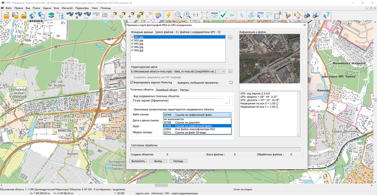
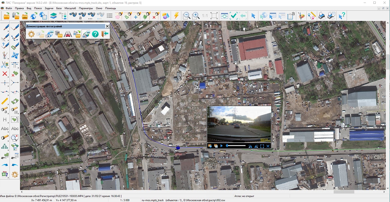
Specialists of KB "Panorama" have prepared a video lesson on using the mode and the task . The mode "To locate photos of JPEG on map by GPS-coordinates" is used for an automatic binding to a map of JPEG photos containing GPS-coordinates of a shooting's place. The task "Share your photos with the coordinates of the shooting" is intended for viewing video files synchronized with a GPS track received from a car video recorder, a UAV video camera or a mobile phone.
The tutorial demonstrates the work of the modes "To locate photos of JPEG on map by GPS-coordinates" and on the example of the map "Moscow and Moscow region". As source materials, JPEG photographs are presented, which were obtained using devices of an unmanned aerial vehicle with a GPS module, and also a set of video files from a car DVR with GPS binding. When shooting with such devices, an additional structure corresponding to the EXIF format is added into the photo file, in which the geographical coordinates of the shooting's location are recorded. A set of video files from a GPS-linked car DVR is preloaded onto the track map using the mode. The source data can be video files in AVI, MP4 format. The GPS track can be contained in the subtitles of the video file, or in the file of the same name in the GPX, KML or NMEA-0183 format.
The combined technology of superimposition of ground-based photo and video materials with the results of remote sensing data will make it possible to more accurately obtain information about terrain objects. This technology is widely used in the railway, automotive and agricultural sectors.
You can get acquainted with the training materials in the "Video lessons" section.

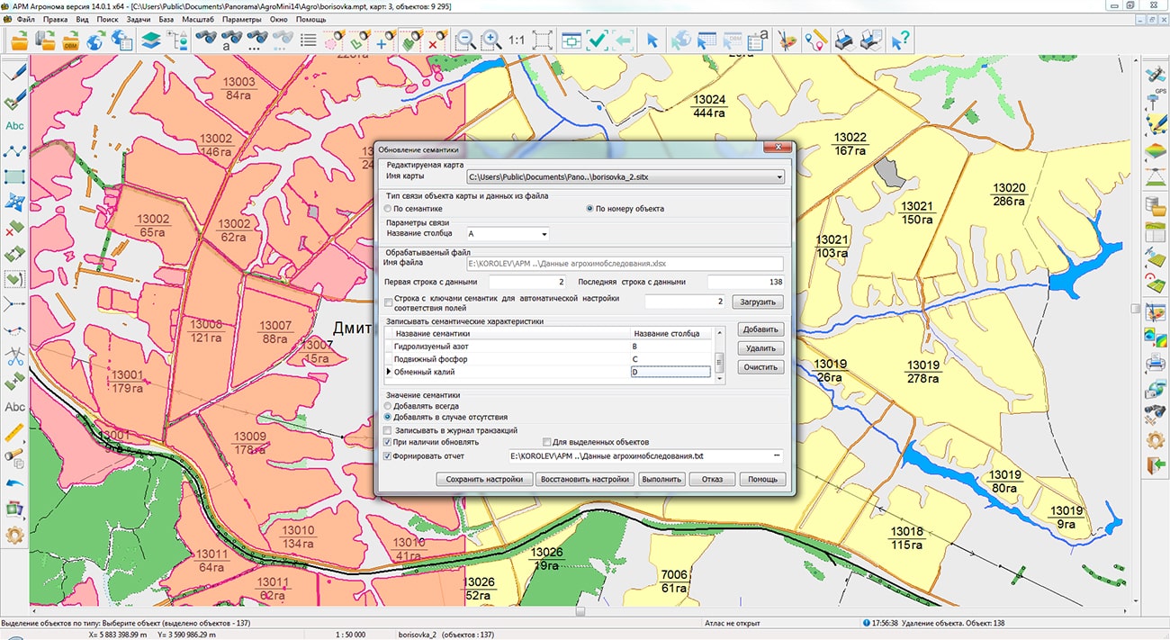
In KB "Panorama" the "Workstation of cadastral engineer" version 14.0.1 has been developed. In the new version the modes and have been improved. The forming a list of semantics for lists of map objects with different classifiers has been implemented. Elements have been added for filtering results of calculation by the "% overlay" indicator. In the dialog "Viewing entry of objects" the elements were added for displaying statistics, including the number of entries and the total area of entries. Report formation in format CSV and XLS has been implemented. Tools for displaying statistics on the map have been added, for this, the corresponding semantics were added into the agro10t.rsc classifier (codes 641, 642 and 643).
In the dialog to maintain a list of types of permitted use of the land management object, an algorithm for dynamic memory allocation is implemented, without restrictions on the number of allowed lines.
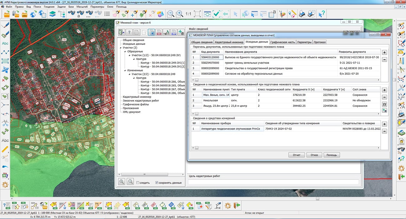
In the mode, the procedure for formation of a text report for subsequent printing has been clarified. In the table of information about the geodetic base, fields have been added to display information about the state of the external sign of the point, the center of the sign and the mark.Order of writing information into the XML file according to the schema version 8 has been changed, the "ContactAddress" element has been moved inside the "Contact Owner" element.
The dialog has been improved, when the dialog is opened, information is displayed only from the repeated semantics of the real estate object. To obtain information about the land plots on which the property is located on the map, a corresponding button has been added.
In the modes "Land survey plan", and , when entering and editing information about the geodetic base, the ability to add geodetic points by calling the "Catalogue of coordinates" dialog has been added. In this case, the "Catalogue of coordinates" mode provides a choice of a geodetic point from the list. The composition of the coordinate catalog has been expanded, the columns "Item type", "Sign state", "Mark state", "Center state" and "Date" have been added.
The mode has been improved. The list of formed semantics is expanded at processing of characteristic points of borders. Reading from XML files and saving information about the method for determining coordinates into the semantics of point objects has been implemented. Creation of new maps, in the absence of the customized parameters of LCS, is carried out with type "Large-scale plan". All new maps are created not according to the classifier of the main map of the open document, but on the classifier survey of the current version that provides correct classification of objects (assignment of codes), created onto a map.
In the mode, the correct processing of maps located for remote collective access on the has been implemented. The blocking of the issuance of diagnostic messages during streaming processing of several objects is provided. Information about erroneous operations is remembered and recorded into the protocol. Based on the results of the mode operation, one message is displayed containing the number of processed objects and the total number of selected objects.
The mode has been improved. The range of possible horizontal scale values has been expanded, up to 1: 100 inclusive for large-scale maps and plans.
In the dialog , the saving of parameters for creating titles in the panorama.ini settings file has been implemented. The parameters are saved automatically and used when the mode is restarted. Codes of points and titles to be created are customized by means of the "Parameters of the geodetic editor" dialog.
The new version of the program is available on the website in the Download section.


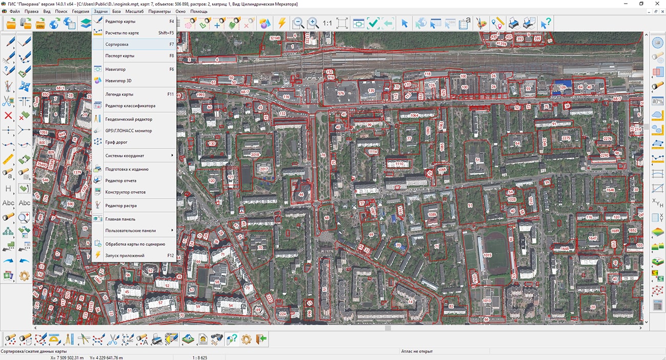
Specialists of KB "Panorama" have prepared a video lesson on sorting map objects. Users of the can independently perform the procedure of sorting data. The tutorial demonstrates the task. This tool organizes the placement of object descriptions in metrics and semantics files, which speeds up their further processing and ensures the correct sequence of displaying objects. In addition, when sorting, you can exclude from files the metrics and semantics of deleted objects and copies of edited objects. Thus, data compression is performed. Sorting map objects can change the accuracy of data storage (the number of decimal places) and the system of stored coordinates of objects - flat rectangular in meters or geodetic in radians. Storing coordinates in radians speeds up the display of maps when it is required to perform recalculation into different display projections "on the fly", and allows you to create maps of any length in longitude. Storing coordinates in meters significantly speeds up the display of the map in its projection.
For the correct formation of land management documentation, calculation of lengths, areas, a list of coordinates, it is additionally recommended to set the storage accuracy in millimeters or centimeters. This will provide uniformity of calculation results in tasks (, , and others) without additional parameter settings. Sorting allows to change a format of a vector map. At sorting with change of a data format, the files of the initial format of a map are automatically deleted. Formats SITX, SITZ, MAPZ can be converted back to initial formats SIT or MAP by sorting. Packaged maps, when reverse conversion, retain the metric accuracy in centimeters. The coordinates of objects in centimeters are stored in integers, which reduces the size of the metric files by half.
You can get acquainted with the training materials in the "Video lessons" section.


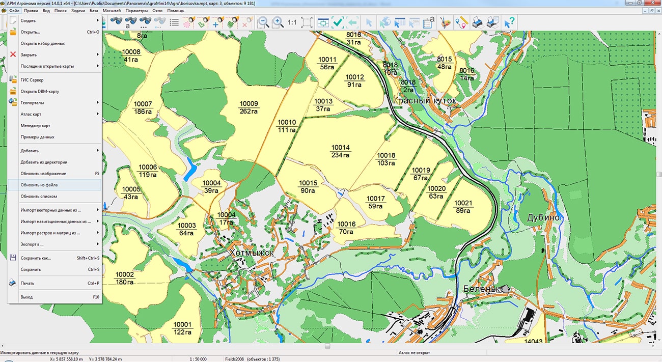
In KB "Panorama" the agrarian geoinformation system "Workstation of agronomist" version 14.0.1.6 has been developed. The new version adds a mechanism for updating cartographic data from files of various types.
Due to the lack of control over agricultural operations, many agricultural producers lose their crops and profits. Mistakes are made at all stages of growing crops: from improper soil preparation, fertilization, sowing and vegetation and finishing by untimely or poor-quality harvesting. "Workstation of agronomist" implements the automated agroscouting technologies, allows you to import spatial and attributive information from Excel, DBF, TXT, CSV files and update existing maps of farmland on its basis. Thanks to the ability to save the settings, the operation of entering or synchronizing data can be easily carried out on a regular basis.
The set of programs "Workstation of agronomist" is an automated workstation of an agronomist based on the and an additional module "Complex of agronomical tasks". The software tools included in the complex include the necessary set of tools for creating and editing electronic maps, and also conducting a sectoral database of agricultural land. In addition, the program allows you to process data from satellite monitoring of fields, connect external data sources from the Internet, form thematic cartograms of fields and reporting documents using customizable templates.
Conducting passports of fields is carried out in structure of information base the , which allows the joint use of these products. Multi-user access, separation of rights, data encryption and load scaling are provided by means of the . The web application provides remote access to the agricultural enterprise management system using a web browser.
GIS of an agricultural enterprise, built on the basis of geoinformation systems of KB "Panorama", allows companies to keep a long history of their fields with photographs, descriptions and reporting. Digital data provide identification and solution of the problem, give forecasts of plant development and yield, taking into account the characteristics of the fields. Correction of agricultural technologies is possible both at the planning stage and during field work. Agroscouting, in addition, allows you to organize effective and fast communication between managers and agronomists.
The new version of the program is available on the website in the Download section.

Ph.: +7 (495) 739-0245, +7 (925) 221-1603
www.gisinfo.ru | panorama@gisinfo.ru
105005, Russia, Moscow, Baumanskaya Street 7, building 1, office 229 (m. Baumanskaya)
Copyright © Panorama Group 1991 - 2024


 Mobile version
 Full version