Copyright © Panorama Group 1991 - 2024

In KB "Panorama" the program version 14 has been developed. In the new version the tools of creating and updating special maps, displaying of remote sensing data, import and export of the spatial data, construction of reports and others were updated.
In the task on the "Edit height" panel, the mode has been added. The mode allows for a selected object or for selected objects to convert 4-dimensional coordinates, containing in the 4-th dimension a floating-point number (M) or a pair of integer values (F), into 3-dimensional coordinates. The mode "Delete height from metrics of objects" converts the 4-dimensional or 3-dimensional coordinates into 2-dimensional coordinates. On the "Object creating" panel, the mode of drawing an object of the TITLE type has been improved. For precise binding of the title to the object, the mechanism of capture of the object point is used when the cursor is hovering over the vicinity of the point. Capture mode starts when you select the "Capture and copy object node" pop-up menu item or when you press the K hotkey. The title metrics will contain exact coordinates of the chosen vertex of object.
The task "Lists of objects" has been improved, which allows performing operations on sets of objects: selection, union, intersection, search for intersecting objects with different types of intersection, search by distance, construction of zones and others. mode was added for cutting the objects of the reference list from the objects of the edited list. The reference list should contain areal objects, the contours of which will be used to edit the objects of the edited list. Objects from the reference list are not edited, except for the case when the intersection points with the edited object are inserted into the reference object.
In the properties of the symbolical semantics in the , you can enter a string pattern that defines the valid characters in the string value or a template for a special string, for example, GUID, cadastral number, and others. For strings that have a value template, when you enter a value in the Select Object dialog box, its compliance with the template is checked.
The task has been improved. The "Control of lack of base and secondary horizontals" mode is divided into two separate modes - "Control of lack of base" and "Control of lack of secondary". Depending on the area, additional horizontals not always must be present on the map. In this case, disabling the control of lack of secondary horizontals allows you to reduce the number of messages issued by the program, which facilitates the analysis of the control results. In the task the Quality control of a vector map, a check of the values of symbolic semantics to a template, if it is specified in the Classifier Editor, is added. "Excluding topology" option has been added into the control of metric's double points. When the "Excluding topology" option is enabled, the presence of double points is performed only according to the metric of the controlled object.
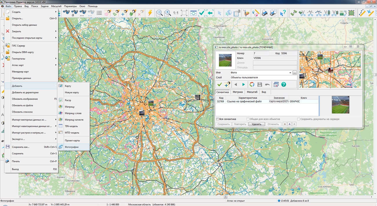
The task from the "File" menu has been improved. Photos are displayed on the map as icons (thumbnails). When the map is increased, the photo is enlarged, allowing you to see the photo in more detail. The algorithm of automatic clustering has been used to the grouping of photos on a map when scaling. Densely located objects with photos are replaced with the first object in a cluster with indicating the number of photos in the given cell. To load photos, you must select a folder with photos. Upon completion of the selection, a service map containing point objects in the form of photographs will be added to the open document. A link to the photo files will be written into these objects. The service map is saved in the document folder and is included into the document maps list. When you reopen the document, the map with photos opens automatically. If necessary, a list of all open data can be saved into an MPT or MPTZ project.
used for grouping point conventional signs on a map has been improved. Into the cluster description the property "Display the first character in the cluster" has been added. Placing it in the position of the cluster sign will first display the first object in the cluster and then the cluster icon. In this case, the cluster icon can contain only the number of objects or other complementary elements of the conventional symbol. When drawing an object, various semantics can be taken into account, including links to graphic files, which makes the generalized sign more complex and informative.
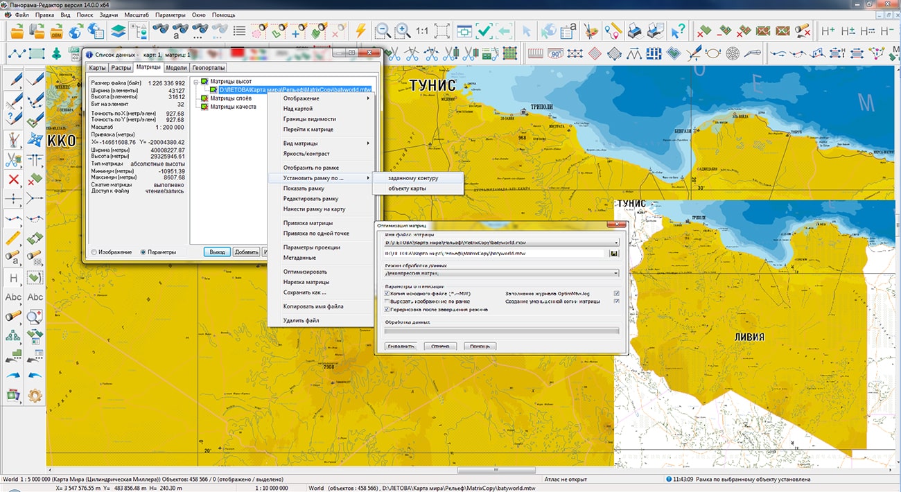
Display of raster data limited by a framework has been improved. The image of such rasters is cut out by a contour of a frame of any complexity. The frame can be set by any closed contour, or by a selected object. The frame can contain thousands of points and thousands of contours, as well as many times exceeds the raster by the area. A large number of frame points decreases the speed of displaying the raster. To speed up the display of rasters, an optimization of the raster frame during recording has been added - all frame contours are cut out by the sizes of each raster. When opening the rasters and matrixes of heights created earlier, frame optimization is performed automatically (the sign of frame optimization is entered into the file). This approach allows you to speed up the display of both new raster data and previously created ones.
In the task the ability has been added for creating a project of arbitrary size. When drawing a new inset of the map, it became possible to draw it exactly along the frame of the work area, that is, to create a general background of the document. Controls have been added for the order in which objects are displayed on the document ("Above all", "Below all"). A new "Open Stamp" mode has been added, which allows you to add one or several previously prepared stamp templates (corner stamps, headers and footers, etc.) into the document with the ability to preview the image of the inserted stamp. The new modes complement the task tools that provide fast and high-quality creation and design of graphic documents.
In the task an export of an image of an open document into the KMZ format has been added. The formed KMZ archive contains the KML project file and a set of raster tiles pyramid for the saved territory. The KML file contains a description of the raster data parameters - the names and coordinates of the rasters binding, as well as the priority of their display. In addition to the KMZ format, the task can save images into BMP, TIFF, JPEG, PNG and RSW formats. A fragment of a digital map document of any type and composition can be saved, including vector maps, images and matrices, as well as geospatial data from external Internet resources (WMS and WFS - services) and databases. In the task, it is possible to save the map image by the selected area, by the page format and by the dimensions of the selected objects, for example, by the dimensions of the frames of the nomenclature sheets.
In the task the list of saved file formats has been expanded. Along with TXT and TIFF files,the ability was added to save a digital elevation matrix into a KMZ file. The formed KMZ file is an archive with the KML project and a set of tiles - single-channel GeoTIFF files with data on the heights of the relief. The KML file contains a description of the data: file names and tile binding coordinates, as well as the priority of their display. The task is called using the main menu item "File - Export to .. - Matrix (TXT, TIFF, KMZ)".
The initial opening of large vector maps, containing several million objects and more has been accelerated after importing data from exchange formats or databases from tens of seconds to fractions of a second. There is improved a positioning of objects added onto a map in the display sequence chain, as when sorting a map. This improves the quality and ease of editing the map, speeds up the initial construction of the object tree when opening the datasets.
The new version of the program is available for download in the Download section.


Specialists of KB "Panorama" have prepared a video lesson on the formation of an XML document and a paper report of the technical plan of version 06 release 4 for the cadastral registration of a car space. Users of 14, 14 or "Workstation of cadastral engineer" can form XML documents and paper reports of the technical plan by means of a complex of geodesy calculations.
The training material demonstrates the features of data preparation, filling in the mandatory characteristics and the formation of an XML file and a paper report of the technical plan of version 06 in accordance with the Order of the Ministry of Economic Development of the Russian Federation from December, 18th, 2015 № 953. On the basis of this order in software products of KB "Panorama" the classifier of conventional symbols survey.v5.rscz has been developed. In the classifier there is implemented a general list of layers, semantic characteristics and objects for display of cadastral data on cadastral maps and other cadastral documents.
can be formed for one or several objects of real estate depending on a variant of a selecting the objects on a cadastral map. Procedures "Formation of XML document and "Formation of a text report" are performed in the "Technical plan" dialog. The initial initialization of the dialog content and the specifying the type of real estate object is performed based on information from the digital cadastral map, taking into account the chosen mode of formation.
Elements for entering and editing data in the "Technical plan" dialog are sorted into groups, in accordance with the sections and details of the technical plan, and arranged by screen pages (bookmarks):
- ;
- ;
- ;
- ;
- ;
- .
You can get acquainted with the training materials in the "Video lessons" section.


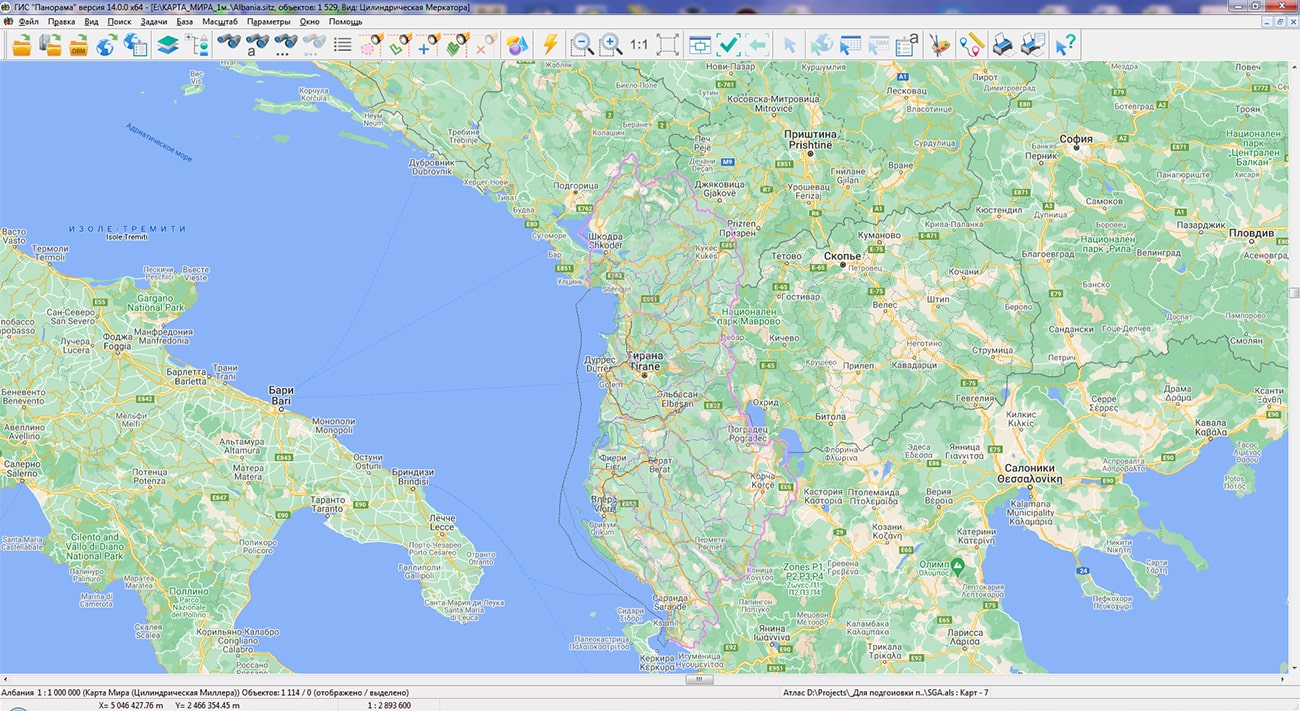
In KB "Panorama" a digital geographic map of scale 1: 1 000 000 in format SXF onto territory of the Albania has been prepared. As a source for preparation of the map the obtained from the information from the site has served. The map contains information on the number of inhabitants for cities and the name of settlements in Russian. As additional materials the World map of scale 1: 5 000 000 and OpenStreetMap data were used.
The map was led to the classifier of geographic maps of scale 1: 1 000 000 (). It can be used for a general assessment of the area and the study of natural conditions, to ensure the educational process, as a basis for the creation of geographic maps of a smaller scale, thematic and special maps, and solving other tasks. The map is distributed free of charge under a free .
Digital geographic map of scale 1: 1 000 000 in SXF format is available for download on the page "Digital maps".


In KB "Panorama" the "Workstation of Agronomist" version 14 has been developed. The new version adds the ability to automatically build maps of land holdings using the service.
The service uses a neural network to decrypt land plots and determine the boundaries of the contours of agricultural land. Information processing is performed on the local territory bounded by the polygon indicated on the map. Building a vector model of working areas of arable land in GeoJSON format is carried out on the basis of automatically selected actual data of average (10 m/px) and high resolution (1.2 m/px). The resulting maps of farmland have an accuracy comparable to the manual work of specialist-cartographers, but are created in much less time.
On the basis of the digital model of farmland, all agrotechnical calculations performed by the program are carried out: conducting passports of fields, building thematic cartograms, obtaining vegetation indices, maps of heterogeneity and need for nitrogen, calculating the application of fertilizer doses, and others.
"Workstation of Agronomist" is included into the line of agricultural GIS KB "Panorama", which also includes , Panorama AGRO Service and . The combination of these products with each other, as well as their combination with the and , allow, depending on the specified tasks, to configure corporate and regional agricultural geographic information systems of any complexity.
The new version of "Workstation of Agronomist" and other products of the company can be downloaded from our website.


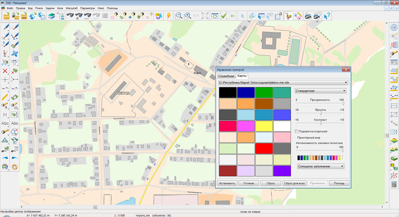
Specialists of KB "Panorama" prepared and placed the map of the Republic of Mari El on the geoportal . The map was formed using OpenStreetMap data, source data was obtained from website. To work with the map, you can use the program or other software products of KB "Panorama".
The map was led to the modernised classifier of large-scale plans of scale 1: 5 000 () and was saved into a packed project (mptz). The MPTZ format project includes a digital map of the region's territory (country, subject of the federation, administrative region), a map of the administrative-territorial division of the region and a digital classifier. Publishing of updates in bank of spatial data is made by using the program of . Publishing contents of bank of spatial data on the geoportal and data access for downloading are implemented by means of .
Free maps on the basis of OpenStreetMap data are available for download on the page "Digital maps".


Ph.: +7 (495) 739-0245, +7 (925) 221-1603
www.gisinfo.ru | panorama@gisinfo.ru
105005, Russia, Moscow, Baumanskaya Street 7, building 1, office 229 (m. Baumanskaya)
Copyright © Panorama Group 1991 - 2024


 Mobile version
 Full version