Copyright © Panorama Group 1991 - 2024

Specialists of KB "Panorama" have prepared a video lesson on the formation of an XML document and a paper report of the technical plan of version 06 release 4 for the cadastral registration of a car space. Users of 14, 14 or "Workstation of cadastral engineer" can form XML documents and paper reports of the technical plan by means of a complex of geodesy calculations.
The training material demonstrates the features of data preparation, filling in the mandatory characteristics and the formation of an XML file and a paper report of the technical plan of version 06 in accordance with the Order of the Ministry of Economic Development of the Russian Federation from December, 18th, 2015 № 953. On the basis of this order in software products of KB "Panorama" the classifier of conventional symbols survey.v5.rscz has been developed. In the classifier there is implemented a general list of layers, semantic characteristics and objects for display of cadastral data on cadastral maps and other cadastral documents.
can be formed for one or several objects of real estate depending on a variant of a selecting the objects on a cadastral map. Procedures "Formation of XML document and "Formation of a text report" are performed in the "Technical plan" dialog. The initial initialization of the dialog content and the specifying the type of real estate object is performed based on information from the digital cadastral map, taking into account the chosen mode of formation.
Elements for entering and editing data in the "Technical plan" dialog are sorted into groups, in accordance with the sections and details of the technical plan, and arranged by screen pages (bookmarks):
- ;
- ;
- ;
- ;
- ;
- .
You can get acquainted with the training materials in the "Video lessons" section.


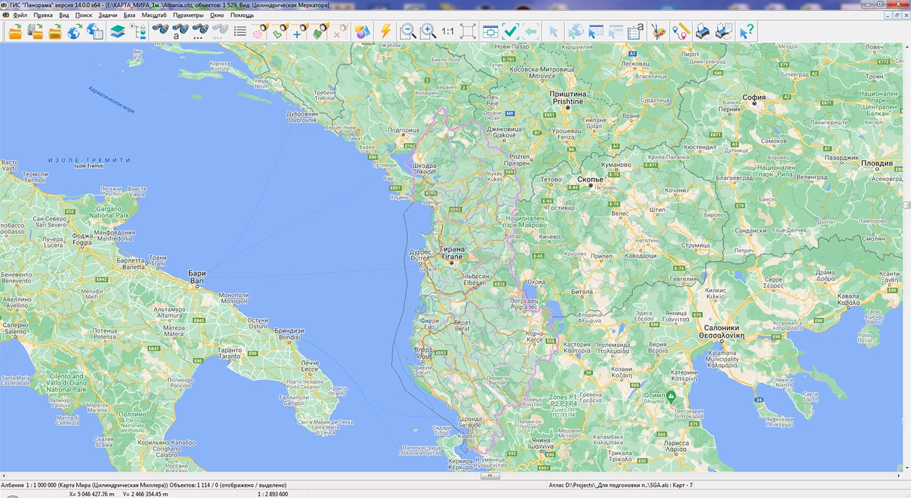
In KB "Panorama" a digital geographic map of scale 1: 1 000 000 in format SXF onto territory of the Albania has been prepared. As a source for preparation of the map the obtained from the information from the site has served. The map contains information on the number of inhabitants for cities and the name of settlements in Russian. As additional materials the World map of scale 1: 5 000 000 and OpenStreetMap data were used.
The map was led to the classifier of geographic maps of scale 1: 1 000 000 (). It can be used for a general assessment of the area and the study of natural conditions, to ensure the educational process, as a basis for the creation of geographic maps of a smaller scale, thematic and special maps, and solving other tasks. The map is distributed free of charge under a free .
Digital geographic map of scale 1: 1 000 000 in SXF format is available for download on the page "Digital maps".


In KB "Panorama" the "Workstation of Agronomist" version 14 has been developed. The new version adds the ability to automatically build maps of land holdings using the service.
The service uses a neural network to decrypt land plots and determine the boundaries of the contours of agricultural land. Information processing is performed on the local territory bounded by the polygon indicated on the map. Building a vector model of working areas of arable land in GeoJSON format is carried out on the basis of automatically selected actual data of average (10 m/px) and high resolution (1.2 m/px). The resulting maps of farmland have an accuracy comparable to the manual work of specialist-cartographers, but are created in much less time.
On the basis of the digital model of farmland, all agrotechnical calculations performed by the program are carried out: conducting passports of fields, building thematic cartograms, obtaining vegetation indices, maps of heterogeneity and need for nitrogen, calculating the application of fertilizer doses, and others.
"Workstation of Agronomist" is included into the line of agricultural GIS KB "Panorama", which also includes , Panorama AGRO Service and . The combination of these products with each other, as well as their combination with the and , allow, depending on the specified tasks, to configure corporate and regional agricultural geographic information systems of any complexity.
The new version of "Workstation of Agronomist" and other products of the company can be downloaded from our website.


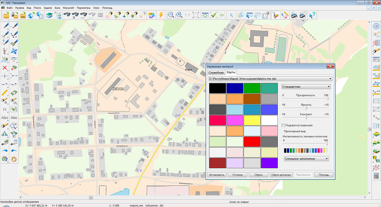
Specialists of KB "Panorama" prepared and placed the map of the Republic of Mari El on the geoportal . The map was formed using OpenStreetMap data, source data was obtained from website. To work with the map, you can use the program or other software products of KB "Panorama".
The map was led to the modernised classifier of large-scale plans of scale 1: 5 000 () and was saved into a packed project (mptz). The MPTZ format project includes a digital map of the region's territory (country, subject of the federation, administrative region), a map of the administrative-territorial division of the region and a digital classifier. Publishing of updates in bank of spatial data is made by using the program of . Publishing contents of bank of spatial data on the geoportal and data access for downloading are implemented by means of .
Free maps on the basis of OpenStreetMap data are available for download on the page "Digital maps".


In KB "Panorama" the of version 6.0.0 has been developed, which supports high-performance scalable technology for collecting, processing, storing and issuing various types of spatial data of large volumes. In the new version a balancing of load on several servers of receiving, processing and issuing data has been implemented. Data download requests are automatically split into multiple streams directed to different servers. Placement of spatial data into file storage is performed with integrity check, control of data structure and content. The results of the work are recorded in the diagnostic log and entered into the metadata base. Statistics on server resources are kept - the available number of cores, the amount of RAM, the percentage of memory load.
All servers work with a single database and a single repository of spatial datasets. There is provided an automatic backup of metadata and repository of spatial datasets into two different backup repositories with integrity control and data recovery.
Basic authentication, digest authentication, system authentication (via web server), and domain (Kerberos or Active Directory) are supported. The complex is adapted for work on a wide range of operating systems (Astra Linux SE, ALT Linux, Elbrus, Ubuntu, CentOS, MS Windows and others) and architectures (Intel, Elbrus).
Search and selection of data has been simplified when working with the complex. Display of sections of the complex is implemented in the form of a tree. All data are combined into groups that are displayed by tree nodes. Selecting a specific group automatically filters the metadata tables. The number of data groups is not limited and is customized in the complex's administrator.
There is added a support for metadata used in the production of digital cartographic products by Roscartography enterprises. The information on a report by a framework, the information on the contract has been added.
Multilingual interface is supported. The complex for maintaining a databank of digital maps and remote sensing data of the earth is registered in the register of domestic software under number 1862.
The databank of digital maps and remote sensing data is the basis for building infrastructure of spatial data at the federal, regional and municipal levels, in corporate information systems. Within the framework of a single geoinformation space, the Data Bank of digital maps and remote sensing data realises gathering, storage, search and delivery of the spatial data in exchange formats. The spatial data selected by means of the program can be placed for the multiuser access on the and be published according to the international standards OGC WFS, WFS-T, WMS, WMTS, WCS on application server the . Users can access data from both a thin client (by means of ) and from desktop applications (, ). The databank of digital maps and remote sensing data provides construction of cloud warehouse of spatial data, provision of access to these data, the automated formation and updating of geo-covers. The current state of spatial data is displayed by means of maps-schemes that are maintained for each type of stored data: vector maps, remote sensing data, elevation matrixes and terrain models. It provides remote placing the sets of spatial data into file warehouse, keeping versions of stored sets, updating maps-schemes of data availability, the automated collection and formation of metadata, and the formation and updating of geo-covers. Automated collection and formation of metadata is performed according to the standards of ISO 19115: 2003, Geographic information - Metadata and ISO/TS 19139, Geographic information - Metadata - XML schema implementation. The reduced copies of data images are automatically formed, checksum of files and completeness of data sets are checked.
The portal presents the possibilities of organizing storage, accounting and and issuance of vector maps, remote sensing data, DEMs and terrain models. The portal contains vector maps in SXF format, generated on the basis of data from open sources (OpenStreetMap, VMap0). The spatial data includes maps of: subjects of the Russian Federation, countries and cities of the near and far abroad. In total, over 230 vector maps and 6500 matrix data with a total volume of 55 GB. Specialists of KB "Panorama" weekly update and refresh the content of the information on the portal. All published data is distributed free of charge under a free license.
The new version of the program is available for download on the page.


Ph.: +7 (495) 739-0245, +7 (925) 221-1603
www.gisinfo.ru | panorama@gisinfo.ru
105005, Russia, Moscow, Baumanskaya Street 7, building 1, office 229 (m. Baumanskaya)
Copyright © Panorama Group 1991 - 2024


 Mobile version
 Full version