Copyright © Panorama Group 1991 - 2024

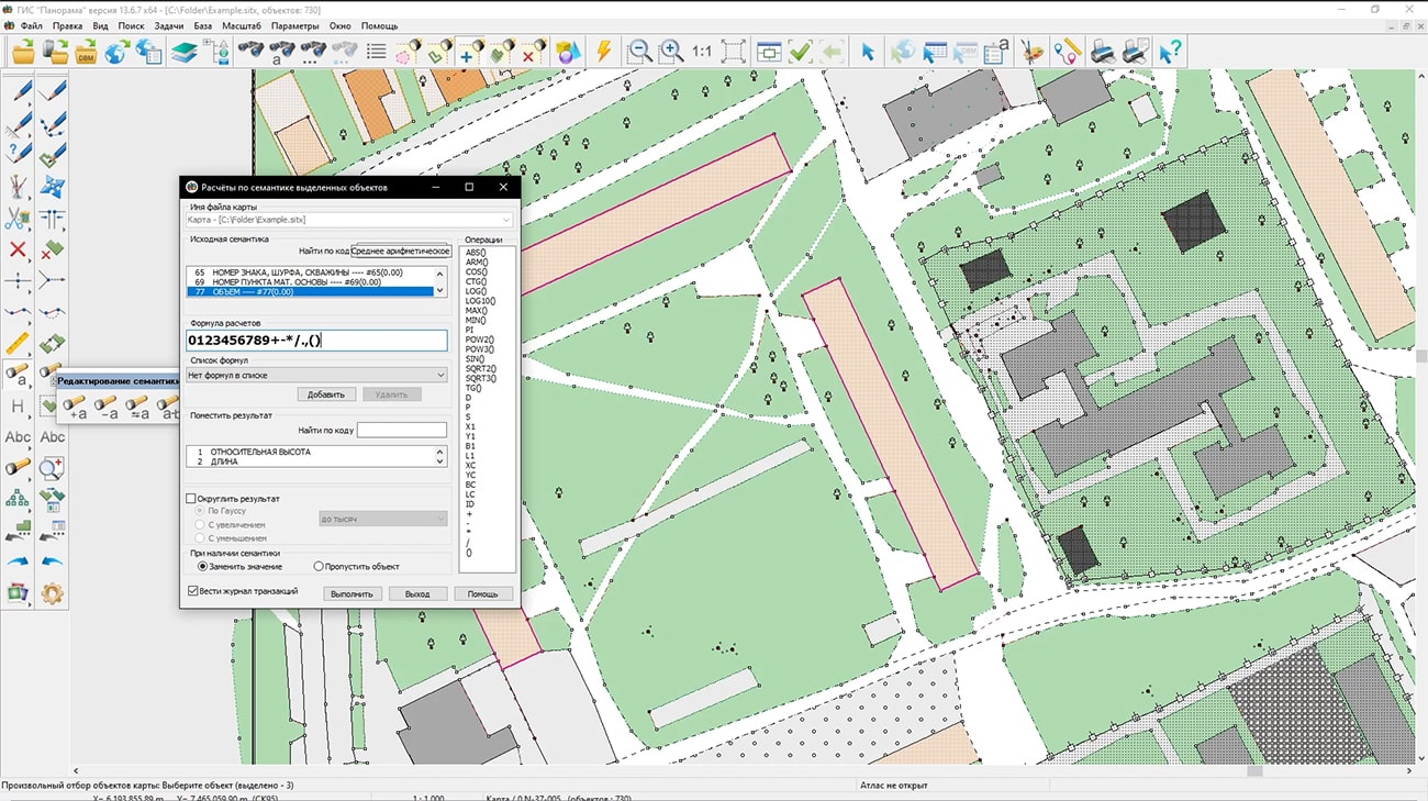
Specialists of KB "Panorama" have prepared a video lesson "Calculations by semantics of selected objects". Users of the can independently carry out calculations of the characteristics of objects by formulas, which are a symbolic string containing numbers, mathematical operations, links onto the values of the semantics of the object, its area and perimeter and other properties.
The tutorial demonstrates the mathematical operations available to process the characteristics of objects. The possibilities for processing the obtained results of the existing characteristics are shown. The tool is intended to calculate the values of the semantic characteristics of selected objects according to user-specified formulas. Users can create their own list of formulas for calculation, typed formulas are written into a file with parameters. If the formula is syntactically incorrect, then neither recording nor calculation is performed. In this case, the message "Incorrect setting of the formula" is displayed with a short decoding of the possible error.
You can get acquainted with the training materials in the "Video lessons" section.


In KB "Panorama" the version 13.6.7 has been developed. In the new version the import of data about a relief from files of has been added. ArcInfo Binary Grid files can contain a digital elevation model, a slope model, and a relief shading. Data in binary Files ArcInfo Binary Grid is organised in the form of a regular grid. The digital elevation model contains elevation data as a cell value of regular grid. According to digital model of a relief the matrixes of heights MTW are formed. To store a relief shading, the value of the regular grid cell corresponds to the degree of illumination. The files containing a relief shading or model of slopes, are converted into matrixes of qualities MTQ. The task of importing matrixes of elevations also supports loading of the data from the SRTM, GeoTIFF, IMG, DEM formats. The import of the pyramid of matrixes of elevations of relief from the KMZ format into a set of MTW files, combined into a single MPT project, has been provided.
Panorama editor provides work with . Support of international standards and data exchange protocols OGC WMS, OGC WMTS and TMS allows you to receive any spatial information from services located in the Internet. Viewing DigitalGlobe images together with other spatial data allows you to get more visual information on the required territory. The services OpenStreetMap (Map), Kosmosnimki (Satellite), Virtual Earth (Satellite), Virtual Earth (Map), Yandex (Satellite), Yandex (Map) and others can act as a substrate for any spatial data.
The task has been improved. There are added the modes: Automatic setting of field matching by semantics key, Save/Restoring settings, Delete a list of semantics. In the dialog of semantics selection a search by key, code or name has been added. Execution of function of updating the list of semantics by all objects or objects selected according to certain conditions is accelerated.
In the , onto the panel, a mode has been added for quickly drawing "icons" on the map - graphic files of BMP, PNG, JPEG, ICO, TIF and others formats. The selected graphic files are copied into the map subdirectory with the name \map name.images. The relative path to the file is recorded into the semantics of the graphic object. When copying a map to another folder, you must also copy the subdirectory with graphic files. When scaling a map the raster symbol can decrease and increase. When packing a map in SITZ\MAPZ\MPTZ formats, graphic files are packed automatically.
The item has been added into the menu. This mode allows you to simultaneously copy to the clipboard and delete selected objects on the map. Cutting of selected objects is carried out by the Ctrl+X hotkey combination. "Quick deletion" of selected objects without copying to the clipboard - Ctrl+Delete.
Display, editing and search in area of objects for vector maps of large volume (from hundreds of thousands to tens of millions of objects in one set - a layer), located locally or on a is accelerated. It is realised at the expense of optimisation of construction and updating of spatial indexes of the objects applied at display and search of the vector data.
is finished. Adjustment of styles of ranges, lines and icons on current graphic parametres of objects on a map is automated. Icons for dot objects are formed in a format png in a folder \imja_kml.icons. Possibility of preservation of a file kml and folders with icons in archive kmz is added.
Improved export to KML format. Automated setting of styles of polygons, lines and icons according to the current graphical parameters of objects on the map. Icons for point objects are generated in png format in the \ kml_name.icons folder. Added the ability to save the kml file and folder with icons to the kmz archive.
The display, editing and a search by area of objects for vector maps of large volume (from hundreds of thousands to tens of millions of objects in one set - a layer) located locally or on the GIS Server have been accelerated. This is implemented by optimizing the construction and updating of spatial indexes of objects used for displaying and searching vector data.
Export to KML format has been improved. A customizing the styles of polygons, lines and icons according to the current graphical parameters of objects on the map was automated. Icons for point objects are generated in png format in the \kml_name.icons folder. Ability has been added of saving the kml file and folder with icons into the kmz archive.
In the application , the "Land survey plan" mode has been improved. An algorithm for processing a cadastral map has been implemented, which provides variable formation of an XML document according to the MP_v06 and MP_v08_R04 schemes. So as in different versions of the XML-scheme of the land survey plan, XSD-directories of the values of the attributes of cadastral objects of different versions are used, they correspond to different versions of the digital classifier survey.rsc. For the MP_v06 XML scheme, the survey.v5.rscz classifier is used, for the MP_v08_R04 XML scheme - survey.v6.rscz. In the "Land Survey plan" dialog in the "Initial data" node in the "Information on geodetic base" table, the ability has been added to enter information about the state of the outside sign of the point, the center of the point and its mark.
The mode has been improved. To fill in the attribute "Cadastral numbers of land plots on which the property is located" there is added an automatic search on the cadastral map of land plots on the territory of which the property is located. For the found plots, the value of the semantics "Cadastral number" is read and stored in the semantics 1350 of the real estate object for reuse.


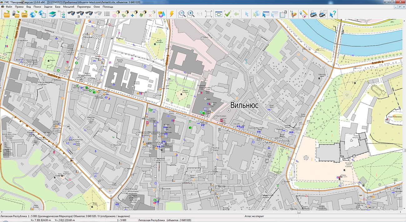
Specialists of KB "Panorama" prepared and placed the map of the Republic of Latvia on the geoportal . Source data was obtained from Geofabrik website. To work with the map, you can use the program or other software products of KB "Panorama".
The map was led to the modernised classifier of large-scale plans of scale 1: 5 000 (map5000m.rsc). Publishing of updates in bank of spatial data is made by using the program of . Publishing contents of bank of spatial data on the geoportal and data access for downloading are implemented by means of .
Free maps on the basis of OpenStreetMap data are available for download on the page "Digital maps".


In KB "Panorama" the version 13.6.7 has been developed. In the new version in the mode, the algorithm for processing the cadastral map is implemented, which provides variable formation of an XML document according to the MP_v06 and MP_v08_R04 schemes. For dialog initialization, the program uses information from a cadastral map. If the map is created according to the survey.v5 classifier, a decision is made to prepare an electronic XML document according to the MP_v06 scheme. If the cadastral map is created according to the survey.v6 classifier, the XML document will be formed according to the MP_v08_R04 scheme. Different versions of the map classifier, correspond to different versions of the XML-scheme of the land survey plan and use values of attributes of cadastral objects from XSD-directories of different versions.
In the "Land Survey plan" dialog in the "Initial data" node in the "Information on geodetic base" table, the ability has been added to enter information about the state of the outside sign of the point, the center of the point and its mark. The recording of information about geodetic network points into an XML file has been improved.
The mode has been improved, when editing information about a zone, in the "Territorial zone - types of permitted use" element, filling in the "Permitted use" column has been added. There is implemented a reading data from a previously created XML file to fill in information in the elements: "Document code" on the "Documents" tab, "Type of subject of legal relations" on the "Applicant" tab and information on the minimum and maximum sizes of land plots.
The dialog has been updated. New elements have been added for entering and editing information about the state of the external sign of the point, the center of the point, its mark and the date of inspection of the point of the geodetic network.
The mode has been improved. To fill in the attribute "Cadastral numbers of land plots on which the property is located" there is added an automatic search on the cadastral map of land plots on the territory of which the property is located. Editing of the table "Previously assigned state registration number of the real estate object" has been corrected. Recording the Definition attribute when forming an XML-file of the technical plan has been corrected.
The modes and have been improved. The order of forming the report for multicontour object and group of the selected objects processed simultaneously was updated. The template scheme.dot has been updated. In the mode "Building a road profile" when forming the multipage report the signature of page numbers was added.
The new version of the program is available on the website in the Download section.


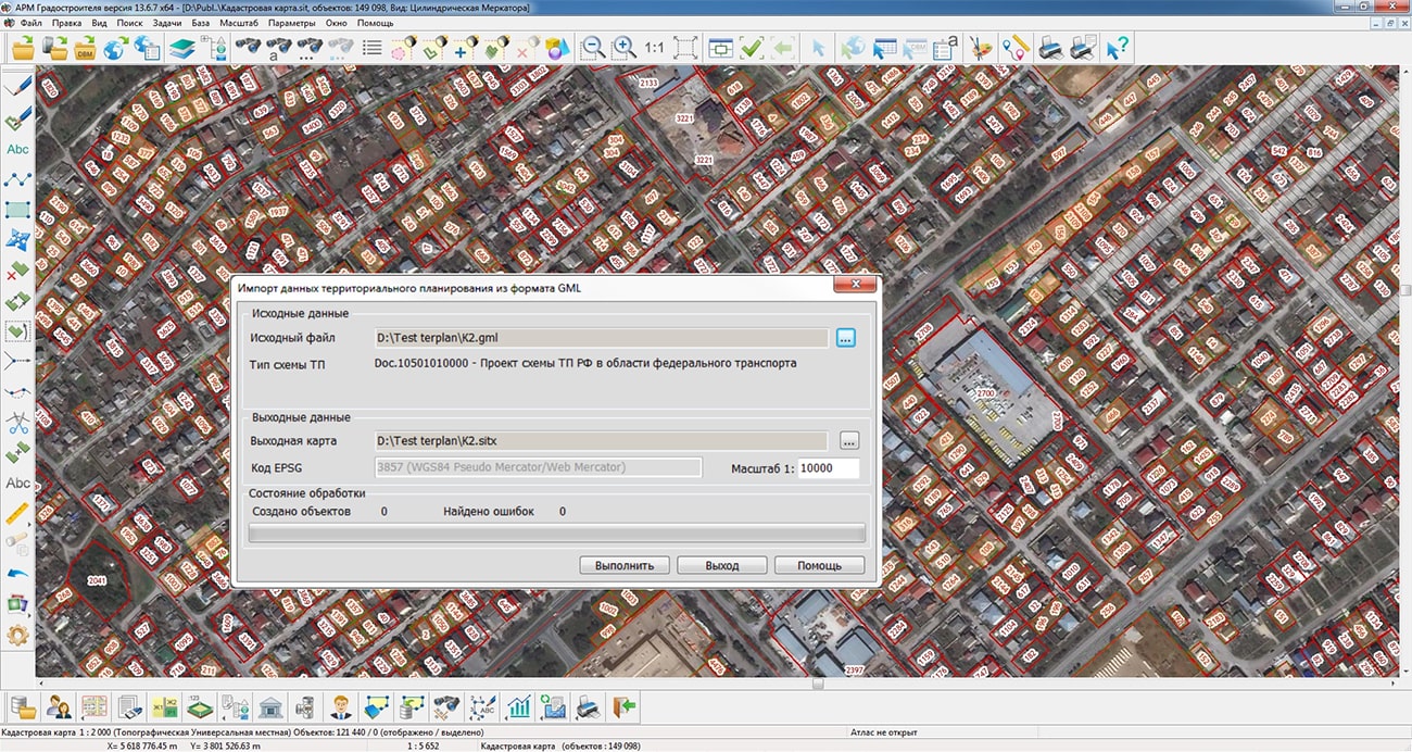
In KB "Panorama" the version 13.6.7 has been developed. In the new version the changes have been made in dialogs of import and export of documents of territorial planning in GML format. The mode has been improved, which provides reading of map objects and their unloading into a file in GML format. Maps of documents of territorial planning should be created on the basis of the digital classifier terplan.v5.rsc which corresponds to the provisions of the order of Ministry of Economic Development of the Russian Federation of January, 9th, 2018 N 10 "On approval of requirements for the description and display in documents of territorial planning of objects of federal significance, objects of regional significance, objects of local significance".
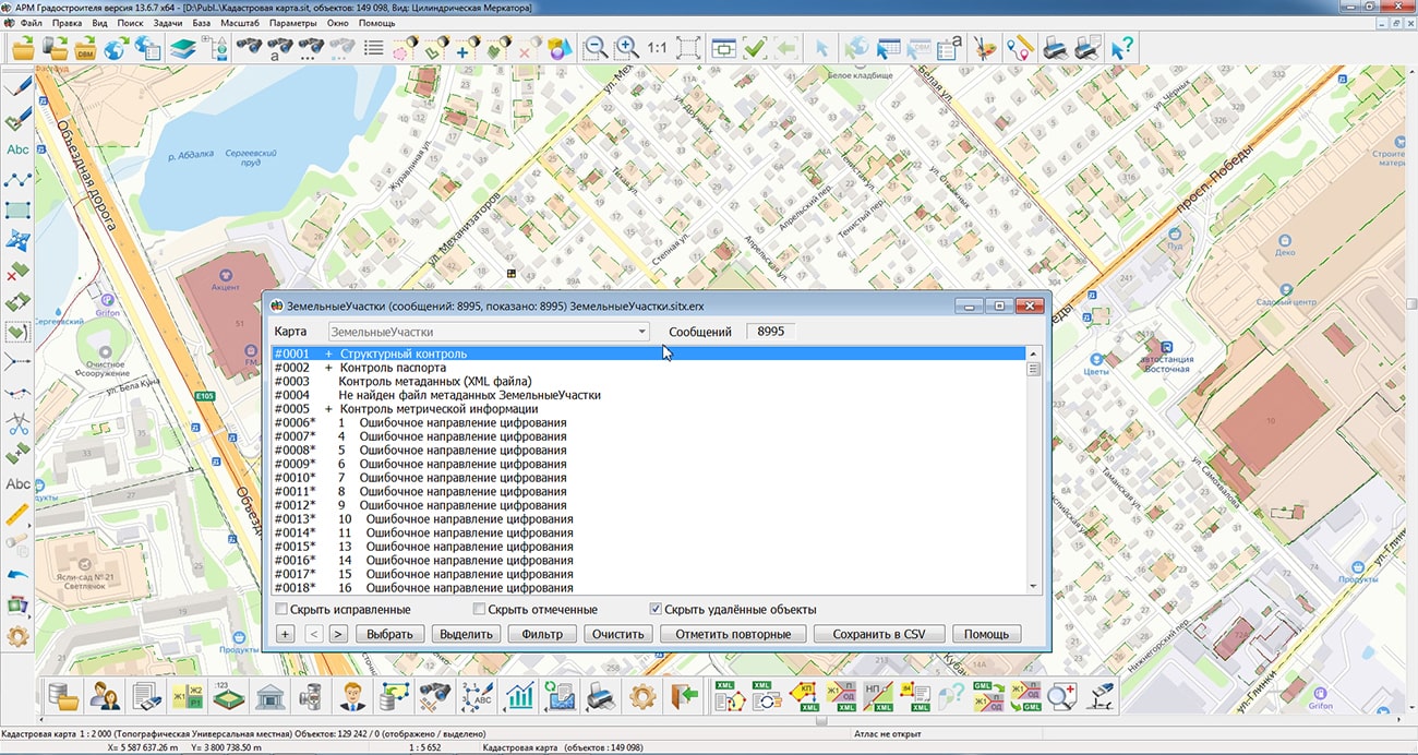
Maps of territorial planning documents are made in accordance with the level of management: territorial planning schemes of the Russian Federation, territorial planning scheme of the subject of the Russian Federation, territorial planning scheme of a municipal district, a general plan of an urban district and a general plan of an urban settlement. To identify errors made by users when drawing objects on the map, including the use of signs of the wrong level, tools for searching and fixing errors have been added. When generating a GML document, control of the presence of mandatory characteristics in the semantics of objects and control of the absence of self-intersections of the metric of linear and areal objects have been implemented. The results of the control are displayed in the task window and are automatically recorded in the protocol. For the analysis and correction of errors, the "View control results" mode has been added, which displays a list of errors and contains navigation tools for moving the map to the location of the detected error.
The mode has been improved. It provides reading GML files, creating a map and drawing objects on it in accordance with the requirements for describing and displaying objects of federal significance, objects of regional significance, objects of local significance in territorial planning documents.
The new version of the program is available on the website in the Download section.

Ph.: +7 (495) 739-0245, +7 (925) 221-1603
www.gisinfo.ru | panorama@gisinfo.ru
105005, Russia, Moscow, Baumanskaya Street 7, building 1, office 229 (m. Baumanskaya)
Copyright © Panorama Group 1991 - 2024


 Mobile version
 Full version