Copyright © Panorama Group 1991 - 2024

In KB "Panorama" the version 13.10.1 has been developed. The new version of the service performs calculations on a cloud server, providing remote access to spatial information for users. For complex information systems, an important indicator is the volume of information transmitted through the cloud over the network. In order to increase the throughput, a new protocol for interacting with the service in the JSON format has been developed. Using JSON will reduce the traffic for transferring requests and responses by an average of 4 times compared to XML-RPC. The use of the JSON standard will simplify the process of integrating the service with third-party systems and libraries. To reduce the size of the transmitted parameters, the ability to set common parameters for all layers has been added into the request structure.
Security of the service work has been increased when exchanging data via sockets with the PHP module. All addresses are closed except 127.0.0.1. Now to the GIS Application Service module , the requests through sockets can be submitted only from the local machine. In order to reduce the size of the recorded event logs, their formation is divided by days. Tools of writing the user libraries by means of SDK have been expanded. Examples on creation of the dispatching centre with moving objects were added.
Interface of the administrator has been improved. A new dialog for monitoring the process of loading data into RAM, forming a cache from the , and forming a cache of a dbm layer from a database has been implemented. For loaded systems, the ability to preload data into RAM has been added to speed up the process of accessing data by users.
There is implemented a request to control the metric of an object for self-intersection and junction of contours, search for close points and outliers, and determine the location of contours. For the operation of checking the intersections of two or more layers, an indication of the request execution has been added. For compatibility with old versions of , support for the GetMapList request has been added.
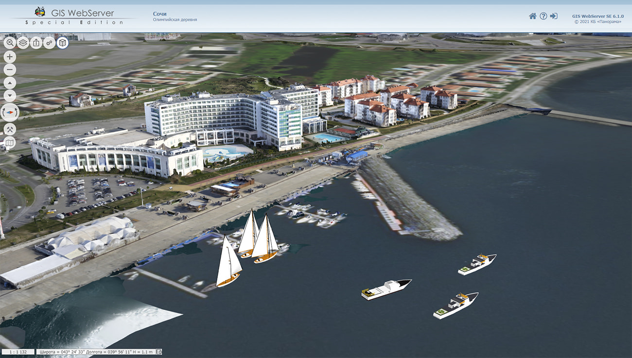
GIS WebService SE supports all international standards (OGC WFS, WFS-T, WMS, WMTS, WCS), which are used to transfer and display spatial data. The program implements the ability to issue tiles for any user or local coordinate system. The application is implemented on Windows and Linux platforms, is compatible with Apache, IIS and nginx web servers.
The new version of the program and the documentation are placed on the website in the section.


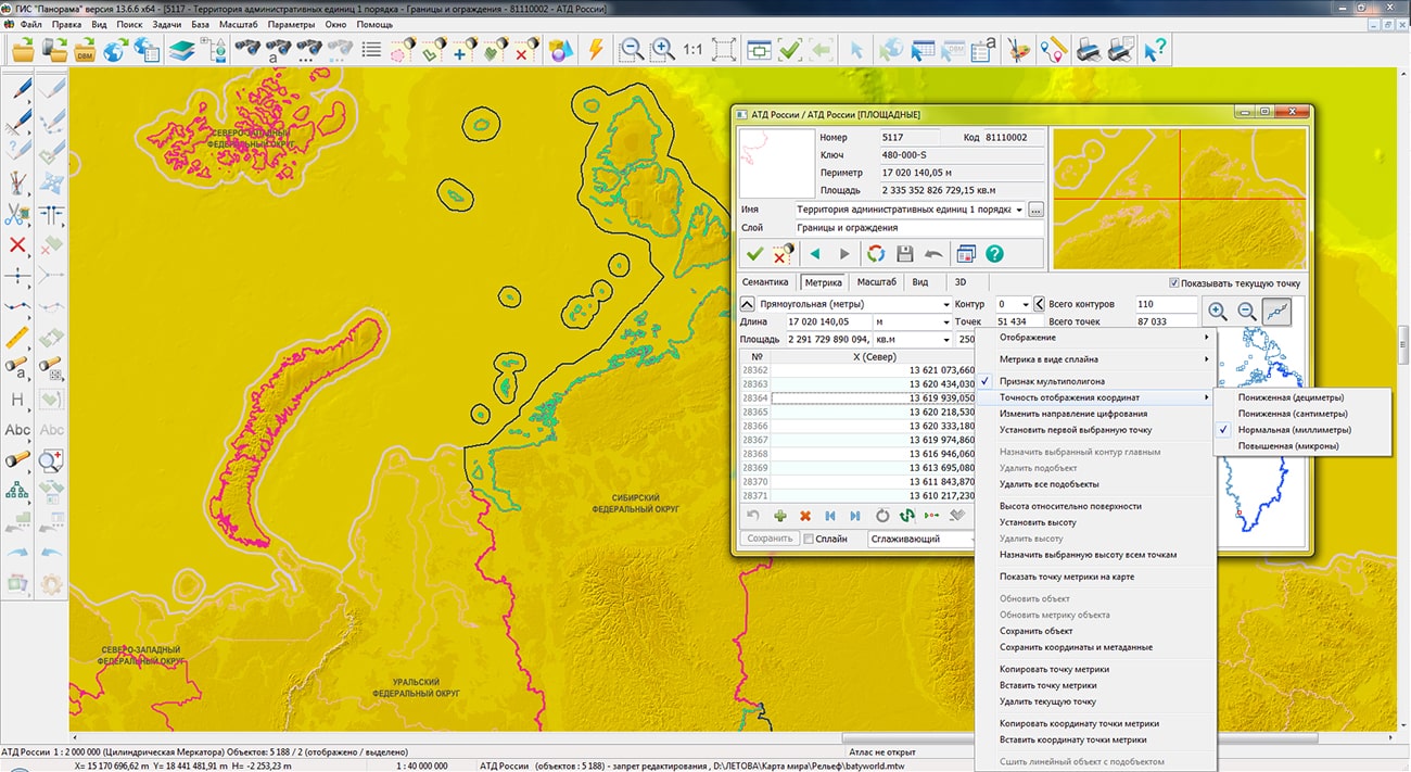
Specialists of KB "Panorama" have updated the digital map of Administrative-territorial division of Russia in SXF format. The map is formed according to OpenStreetMap data from website. It contains territories of federal districts, subjects of the Russian Federation and administrative regions. Total number of objects is 5188.
OKATO codes correspond to Rosstat and FIAS data. The map can be used for the analysis and assessment of territory of the Russian Federation and its subjects, assessment of the borders length and as a basis for creating thematic and special maps.
To work with the resulting map, you can use the program or other software products of KB "Panorama". Free maps based on OpenStreetMap data are available for download on the "Digital maps" page.


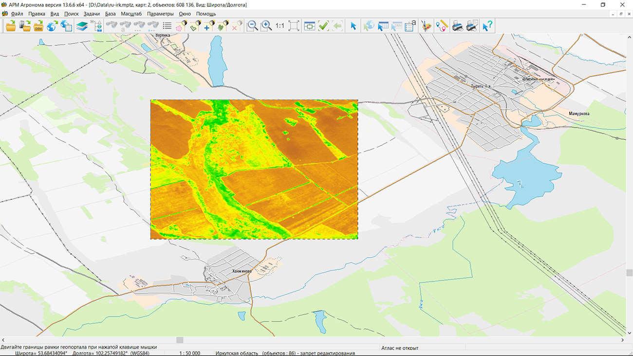
In KB "Panorama" the "Workstation of agronomist" version 13.6.6 has been developed. The new version adds support for working with Earth remote sensing data from the service, created by the - IKI RAS in cooperation with LLC "IKIZ".
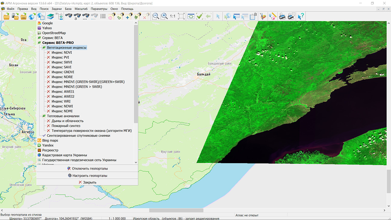
VEGA-PRO is a professional information service that provides access via the WMS protocol to archived and up-to-date data, daily updated satellite images in natural colors and thematic products based on them for analyzing the Earth's surface and monitoring renewable biological resources. The service provides data obtained from satellites LandSat, Sentinel, MODIS, TERRA, KANOPUS, METEOR, RESOURCE and others. A full description of the service's capabilities is available in the documentation.
As part of the "Workstation of agronomist", the service is available in the form of geoportals with layers of coverage based on satellite images in natural colors, a large number of different vegetation indexes and thematic products: smoke, fires, temperature of ocean surface. A layer of coverage with images in natural colors can be used in tasks of monitoring the Earth's surface, for example, for assessing forest and land resources. The images clearly show the change in the forest area caused by fires, deforestation or destruction of the timber stand, as well as the overgrowing of agricultural lands with forests due to their underutilization.
Vegetation indexes are numerical indicators of the quantity and quality of biological resources, calculated on the basis of satellite images. Depending on the type, the indexes can be used in the tasks of assessing the health of vegetation, predicting yields, or determining the effectiveness of fertilization. Indexes NDVI, GNDVI, PVI, SWVI, SAVI, NDRE, MNDVI, AWEI, WRI, NDWI, NDMI are available for viewing.
Thematic anomalies provide information on fire and smoke based on multispectral satellite imagery. "Workstation of an agronomist" provides data content management for all layers from the VEGA-PRO geoportal by using the tools of filtering the source images by date of shooting and total cloud cover.
Access to the service is provided by username and password or by an API access key. The options for providing access are described in the documentation on the service website.
The new version of the program is available on the website in the Download section.


Specialists of KB "Panorama" prepared and placed on the geoportal the map of Krasnodar Krai. The map was formed using OpenStreetMap data, source data was obtained from website. To work with the map, you can use the program or other software products of KB "Panorama".
The map was led to the modernised classifier of large-scale plans of scale 1: 5 000 (map5000m.rsc) and was saved into a packed project (mptz). The MPTZ format project includes a digital map of the region's territory (country, subject of the federation, administrative region), a map of the administrative-territorial division of the region and a digital classifier. Publishing of updates in bank of spatial data is made by using the program of . Publishing contents of bank of spatial data on the geoportal and data access for downloading are implemented by means of .
Free maps on the basis of OpenStreetMap data are available for download on the page "Digital maps".


In KB "Panorama" the version 13.6.6 has been developed. In the new version of the program, animation tools are expanded when creating three-dimensional models. New animated nodes have been added into the "Sign" type template: Smoke, Explosion, Mudflow, Fire hose. The use of animated nodes in the simulation model of emergencies adds an additional effect of realism to dynamic scenes. This is also promoted by the display in a three-dimensional model of military and special equipment, objects of the rear and fortifications, detailed details of the terrain, vegetation, weather conditions and atmospheric phenomena.
For automated construction and analysis of mathematical models of emergency situations, the GIS "Operator" 13 includes the "Forecast of Emergencies" Complex. The complex constructs mathematical models of emergency situations according to the following scenarios: emergency at a chemically hazardous facility, emergency at a radiation hazardous facility, emergency at a biologically hazardous facility, emergency at an explosive facility, emergency at a hydraulic structure. The complex "Forecast of Emergencies" provides the calculation of the flooding zone by the method of alignments, predicts the occurrence of emergency situations on the oil pipeline, simulates the spread of large-scale forest fires.
The new mode "Add Photos" has been developed for fixing the consequences of emergencies which allows to load into an open terrain map of a photo with a geographic location in EXIF tags. Typically, photographs taken with digital cameras and mobile phones equipped with a GPS receiver have such properties. Photos are displayed on the map as icons (thumbnails). When the map is increased, the photo is enlarged, allowing you to see the photo in more detail. Loading of photos is carried out into a service map which is saved in the document folder and is entered into the document maps list. When you reopen the document, the map with photos opens automatically.
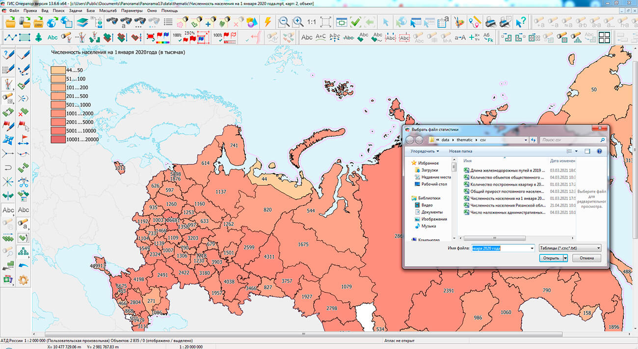
To automate the preparation of infographics from public statistical information by the regions of the Russian Federation and municipal districts, the "Show statistics" mode has been added. Statistical data should be presented in the form of a table in CSV format. The table can consist of two or more columns one of which should contain names of subjects of the Russian Federation or municipal districts of the subject of the Russian Federation. When you open the CSV file, a thematic map is built using the regions.sitz map included in the installation. The map regions.sitz contains objects of administrative division of the Russian Federation: territories of federal districts, subjects and areas. Into the installation of the program, several examples have been added which were loaded from the website of the Federal State Statistics Service (Rosstat). The result of the construction is a thematic map containing the colored territories of the subjects of the Russian Federation or regions of the selected subject, a scale of ranges of values of statistical data and a list of names of territorial objects with the values of the selected statistical data. The resulting map can be printed, or be saved into files of vector (SVG, EMF) and raster (PNG, TIFF) formats.
In the "Creation of thematic map" task, the mode "Coloring by distance from selected objects" has been added. The mode performs coloring of areal objects in accordance with the distance from the selected objects. Polygons for coloring are set by the "Filter" button. For example, to build a map of the distance between forest areas relative to roads it is necessary: to select the road network objects (highways, streets, improved and unpaved roads) on the map, to select polygons for coloring (forest areas) in the dialog and perform construction. The task is started through the main menu Tools/Run applications/Thematic maps and diagrams.
In the "Search by name" dialog, the algorithm of search by the list of strings in the "Partial match" mode has been refined. In each string, a search by partial match is performed for each substring, separated by a space, period, comma, semicolon, or tab. If the substring contains only digits, then the same substring is searched for without other digits at the edges (for substring "21" the substring "121" or "213" will not be found, but "21.0" is acceptable). This allows, for example, to find an address by the first letters of the street name and the exact house number.
The new version of the program is available for download in the section.


Ph.: +7 (495) 739-0245, +7 (925) 221-1603
www.gisinfo.ru | panorama@gisinfo.ru
105005, Russia, Moscow, Baumanskaya Street 7, building 1, office 229 (m. Baumanskaya)
Copyright © Panorama Group 1991 - 2024


 Mobile version
 Full version