Copyright © Panorama Group 1991 - 2024

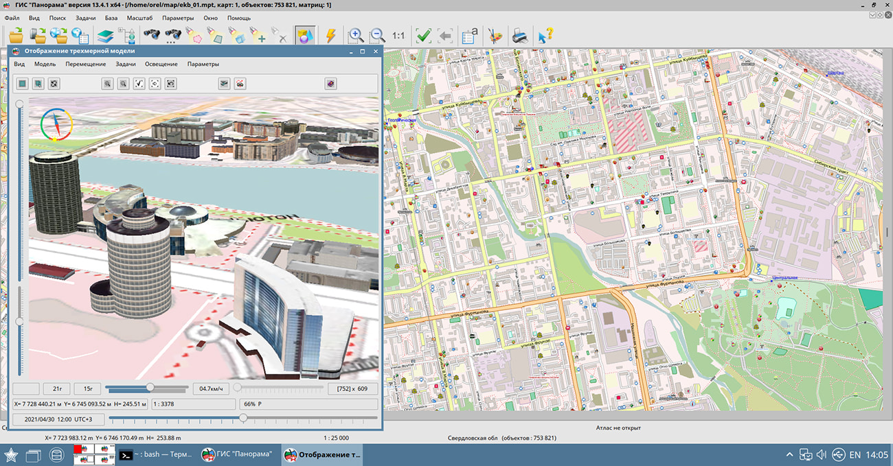
In KB "Panorama" the version 13.4.1 has been developed for the operating system "Astra Linux Common Edition" (Release "Oryol"). The geographic information system is built on a multi-platform multi-threaded kernel for OS Linux, QNX, Android, MS Windows with support of processors Intel/AMD, Elbrus, ARM, PowerPC, SPARC, MIPS and others. To improve the reliability of the software, numerous automated functional tests have been developed, the code has been optimized using text analyzers and performance evaluation on a multicore architecture. GIS "Panorama" provides users with tools for accumulation, storage, automated processing and display of data, calculation results and forecasts with geospatial reference. The system allows you to create vector, raster and matrix maps, as well as promptly update various information about the area.
In the task «Maps manager» the possibility of grouping of heterogeneous spatial data has been added. Thanks to this, the user is able to effectively structure large amounts of information. Into one section of the manager the data from any directory of the file system can be placed. When adding data to a section, the task automatically forms a readable name - a short or full path, depending on the data location.
The possibilities of forming a three-dimensional metric when creating new objects have been expanded. The task interface has been optimised for convenient processing of mass addition of height into map objects. Depending on the settings, the program displays a dialog box for requesting the height for the object being created or writes the last entered value into the object. Formation of a three-dimensional metric is available both for vector objects and for the created raster sign. Parameters for editing three-dimensional metrics can be customized for a specific user in the options of the "Map Editor" mode.
GIS "Panorama" contains a professional digital map editor, which includes a large number of modes. For the convenience of users, the modes are combined into groups: creating objects (basic modes of creating, copying and duplicating), auto shapes (additional modes for creating objects with complex contours: embankments, flyovers, stairs, quarters, bergstrich), graphic objects (additional modes for creating objects in the form simple lines, polygons and labels), topology (modes of matching sections of neighboring objects and their individual points) and many others. You can learn more about the capabilities of the "Map Editor" in the "Documentation".
GIS "Panorama" allows you to combine vector, raster and matrix data in different projections (with performing the transformation on the fly) and use them as a basis for making calculations: obtaining information about the length, area of map objects and arbitrary polygons, building an orthodrome and loxodrome, zones around selected objects, intersection of objects, determination of emptiness, finding the distance between map objects, searching for points on the contour, searching by point, azimuth and distance, performing calculations by matrix of heights (value of the height at a point, building a profile by matrix of heights or arbitrary line, visibility zones, area of the object taking into account the relief, flooding zone).
Using the "Road net" task, users can search for the minimum route between two nodes, taking into account the values of the semantic characteristics of the network edges, find objects within a specified distance from the specified node (remoteness graph) and determine the minimum path between several specified nodes. To build the minimum path, it is necessary to indicate the start and end points of the route (network nodes), the method of construction (by length or by time), if necessary, set the construction criteria by the semantic characteristics of the network edges. As a result of the program's work, the edges that make up the minimum route will be selected on the map, the length of the path will be calculated.
GIS "Panorama" supports import of data from the most popular formats: vector maps , SHP (Shapefile), DXF (AutoCAD), OGC GML (XML), KML (Google), S57 and others; raster data (RSW, BMP, JPEG, PNG, GeoTIFF, TIFF); matrixes of heights and matrixes of qualities MTW, MTQ, GRD, SRTM, GeoTIFF; geological matrixes of layers, TIN models and laser scanning data (point cloud in MTD format); navigation data GPX; aeronautical data ARINC-424.
The user can print open data to various output devices with customizable print parameters. Vector data can be exported into exchange formats SXF, TXF, DIR, SHP (Shapefile), OGC GML (XML) S57, ARINC-424 and others; raster data - in RSW, BMP, JPEG, PNG, TIFF formats.
The software allows you to create new maps in MAP, SIT, SITX formats with automatic filling of parameters using the EPSG code or from the list of parameters in XML format. GIS "Panorama" can be used to create and edit digital topographic, sea, aeronautical and other maps and city plans.
The program includes tools for creating three-dimensional models of varying degrees of detail. The GIS "Panorama" together with classifiers of vector maps includes libraries of three-dimensional images for various scales. To obtain a three-dimensional view of existing digital maps, it is enough to connect one or several libraries to the map classifier. This approach makes it possible to quickly prepare the map for display in three-dimensional form. If you need a more detailed and individual display of the area, you can create your own volumetric images of objects. There is supported an import into DB3D format of Collada (dae) models, OBJ models, TLS (Agisoft Tiled Model) models, point clouds in Agisoft OC3 format. Separate import of point clouds in LAS format. Models of the specified formats can be exported from Geoscan software, programs of SketchUp, Blender, MeshLab, Maya, 3D Studio Max, SP LIRA and others.
The multiuser access to the remote data with control of access by means of connection to the GIS Server is supported. GIS Server provides remote access to vector maps, remote sensing data, matrices, documents, spatial databases and pyramids of tiles in the formats GPKG, BIR, Mbtiles. GIS Server supports work with spatial databases under control of PostgreSQL and Oracle DBMS that support the ability to access spatial data in accordance with the OGC 06-103r4 standard: "OpenGIS Implementation Standard for Geographic information - Simple feature access - Part 1: Common architecture".
Connections to popular geoportals are supported, which allow displaying user maps over images received from the sites OpenStreetMap (Map), Yandex (Sputnik), Yandex (Map), Rosreestr, Kosmosnimki, Monitoring of aircraft movement and others. The list of geoportals is constantly expanding and can be supplemented by system users. In addition, GIS "Panorama" can be used to connect to arbitrary servers using the OGC WMS and OGC WFS protocols (for example, based on GIS WebService SE).
GIS "Panorama" allows you to create diagrams on the map by the values of semantic characteristics. When creating cartograms, there is a possibility of proportional and non-proportional distribution of ranges of values of attribute characteristics. The complex for preparing maps for publication, which is part of the program, is designed to improve the visibility of the printed map, taking into account the requirements for the design of maps. The complex includes tasks for special sorting of maps, out-of-frame design of a multi-sheet map, breadboard models of out-of-frame design and other modes.
The "Astra Linux Common Edition" operating system, the "Oryol" release, which is being developed by the Astra Linux Group of Companies, is a domestic general purpose operating system. This operating system is highly valued not only in government agencies and corporations, whose demand for the quality of IT solutions is a clear marker of their high level of reliability, but also by ordinary users, due to the convenience and compatibility with most products of domestic and foreign manufacturers of software and hardware. On the basis of the "Oryol" release, you can create a full-fledged workstation for solving almost all everyday tasks: working on the Internet, with office or multimedia tools, as well as with applications that require maximum use of the capabilities of graphic video cards, including geoinformation systems.
The new version of the program is available for download in the section.


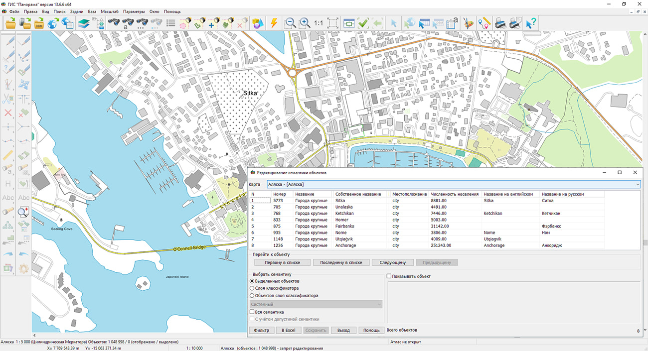
Geoportal has been supplemented with a map of Alaska, formed according to OpenStreetMap data. The initial data is received from site . For work with a map it is possible to use the program Panorama Mini GIS or other software products of KB "Panorama".
The map was led to the modernised classifier of large-scale plans of scale 1: 5 000 (map5000m.rsc). Publishing of updates in bank of spatial data is made by using the program of . Publishing contents of bank of spatial data on the geoportal and data access for downloading are implemented by means of .
Free maps on the basis of OpenStreetMap data are available for download on the page "Digital maps".


In KB "Panorama" the "Workstation of cadastral engineer" version 13.6.6 has been developed. In the "Land Survey Plan" mode, the formation of an XML document according to the MP_v08_R04 XML scheme is implemented. Changes have been made in the algorithm for filling the XML file of the land survey plan in the part of the elements the Package - Information Package, GeneralCadastralWorks - General information about cadastral works, InputData - Input data, Survey - Information about performed measurements and calculations.
When filling in an XML document, attributes of different types are used: number, text, date and value from the directories. For the XML-document of the land survey plan version 8, the attributes directories have been substantially updated. In connection with the updating of the composition and content of XSD-directories of the values of attributes of objects of cadastral registration, the digital classifier survey (survey.v6.rscz) has been updated. This classifier is intended for maintaining a cadastral map containing the objects required for creating an XML document of the land survey plan according to the MP_v08_R04 schema.
Formation of a land survey plan according to the MP_v06 scheme is not supported in program versions 13.6.6 and higher. To form a land survey plan according to the MP_v06 scheme, it is necessary to install the Complex of geodesy calculations of version 13.6.5 on top of the workstation of cadastral engineer 13.6.6 with the choice of the path to the folder \Program Files\Panorama\PanoramaSurvey13.
Dialog "Editing the attributes of the object of cadastral works" has been updated. Elements for entering and editing an extended set of attributes of land plots have been added, including information about the location of the land plot within the boundaries of the territory in respect of which the land survey project has been approved, the scheme of the location of the land plot on the cadastral plan of the territory, information about the location of the land plot within the boundaries of the zone or territory, and information on the permitted use of forests. The auxiliary dialog for entering and editing repeated semantics has been improved, taking into account changes in their composition. The composition of information about the characteristics of the forest area has been expanded.
The algorithm for processing information about the types of permitted use of a land plot has been changed, there were implemented a variable recording of the elements: Utilization - Type of permitted use of the land plot in accordance with the previously used classifier (dUtilizations) and information on the permitted use in accordance with the document, LandUse - Type of permitted use of the land plot in accordance with the classifier approved by the order of the Ministry of Economic Development of Russia dated 01.09.2014 № 540 and PermittedUsesGradReg - Type (types) of permitted use from among the types provided by town planning regulations. The procedure for recording information about the address (description of the location) of the land plot has been updated, there was added a recording of the FIAS element - a unique number of the address-forming element in the state address register.
The mode "Reading the cadastral plan of the territory and updating the map" has been improved, the reading of data according to the extract_about_boundaries_v01 XML schema, used to form an XML document - an extract about the border between the subjects of the Russian Federation, the border of the municipality and the border of the settlement in electronic form, has been updated. Based on the results of reading the XML file, several linear objects are created on the map, corresponding to the type of boundaries and containing the attributes of the objects of cadastral registration. The stream processing of several files is supported.
The dialog "Technical plan" has been improved. For the technical building plan, a recording into the XML file of element the SchemeDisposition - Scheme of the location of the building on the land plot has been corrected. For the technical plan of the premises, the recording into the XML file of the element "View of the living space" has been corrected. The order of inserting the images of floor plan into the text report has been corrected; when reading information from an XML file, the formation of the full path of the image file has been added. Continuous numbering of the characteristic points of the contour boundaries for the multi-contour part of the construction has been added. For the elements GeopointsOpred and TochnGeopointsSubObject, the processing of the metrics of multipolygons that characterize the outer contours of real estate objects has been added.
The new version of the program is available on the website in the Download section.


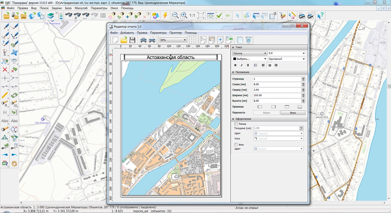
Specialists of KB "Panorama" prepared and placed on the geoportal the map of the Astrakhan region. The map was formed using OpenStreetMap data, source data was obtained from website. To work with the map, you can use the program or other software products of KB "Panorama".
The map was led to the modernised classifier of large-scale plans of scale 1: 5 000 () and were saved into a packed project (MPTZ). The MPTZ format project includes a digital map of the region's territory (country, subject of the federation, administrative region), a map of the administrative-territorial division of the region and a digital classifier. Publishing of updates in bank of spatial data is made by using the program of . Publishing contents of bank of spatial data on the geoportal and data access for downloading are implemented by means of .
Free maps on the basis of OpenStreetMap data are available for download on the page "Digital maps".


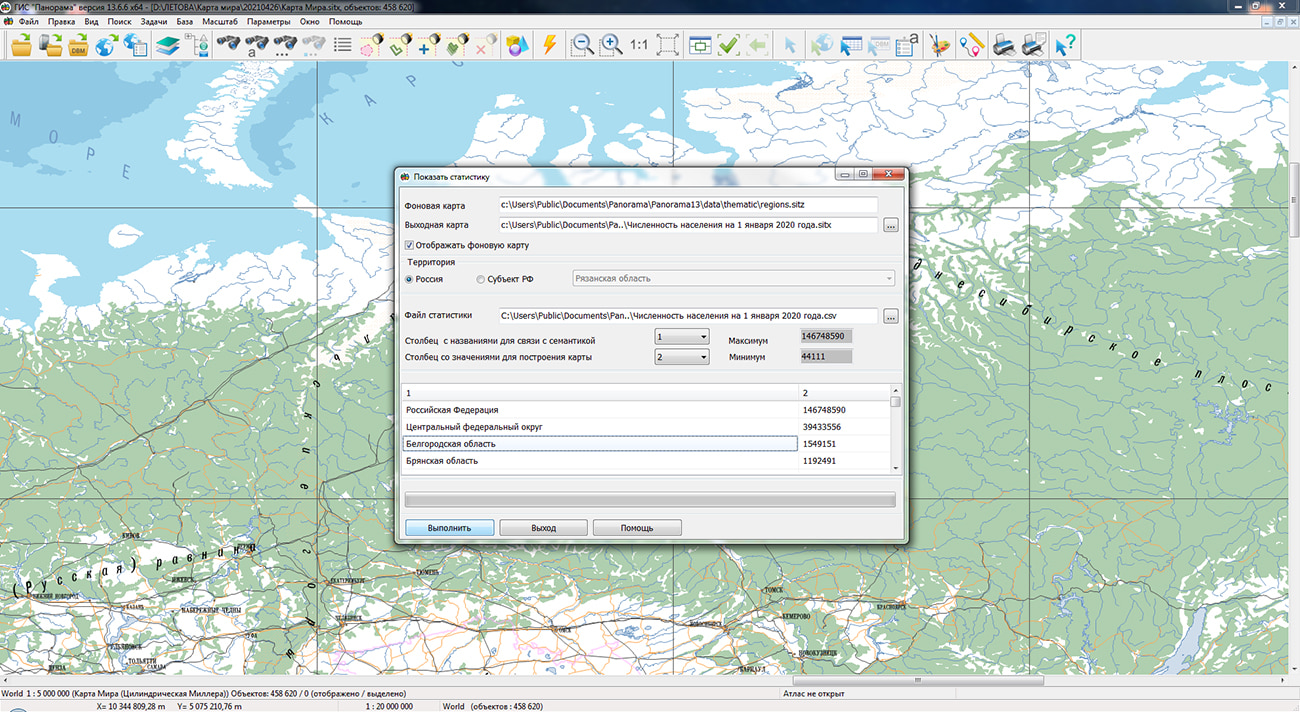
In KB "Panorama" the has been developed. To automate the preparation of infographics from public statistical information by the regions of the Russian Federation and municipal districts, the mode has been added. Statistical data should be presented in the form of a table in CSV format. The table can consist of two or more columns one of which should contain names of subjects of the Russian Federation or municipal districts of the subject of the Russian Federation. When you open the CSV file, a thematic map is built using the regions.sitz map included in the installation. The map regions.sitz contains objects of administrative division of the Russian Federation: territories of federal districts, subjects and areas. The link of table fields with objects of a map is carried out by semantics "Name". To obtain a better result, the table should contain the correct names of subjects or districts. Into the installation of the program, several examples have been added which were loaded from the website of the Federal State Statistics Service (). The result of the construction is a thematic map containing the colored territories of the subjects of the Russian Federation or regions of the selected subject, a scale of ranges of values of statistical data and a list of names of territorial objects with the values of the selected statistical data. The resulting map can be printed, or be saved into files of vector (SVG, EMF) and raster (PNG, TIFF) formats.
In the , the mode "Coloring by distance from selected objects" has been added. The mode performs coloring of areal objects in accordance with the distance from the selected objects. Polygons for coloring are set by the "Filter" button. For example, to build a map of the distance between forest areas relative to roads it is necessary: to select the road network objects (highways, streets, improved and unpaved roads) on the map, to select polygons for coloring (forest areas) in the dialog and perform construction. The task is started through the main menu Tools/Run applications/Thematic maps and diagrams.
New mode allows to load photos containing the coordinates of the geographic location into the open map of the region. Typically, photographs taken with digital cameras and mobile phones equipped with a GPS receiver have such properties. Photos are displayed on the map as icons (thumbnails). When the map is increased, the photo is enlarged, allowing you to see the photo in more detail. Loading of photos is carried out into a service map which is saved in the document folder and is entered into the document maps list. When you reopen the document, the map with photos opens automatically.
In the dialog, the algorithm of search by the list of strings in the "Partial match" mode has been refined. In each string, a search by partial match is performed for each substring, separated by a space, period, comma, semicolon, or tab. If the substring contains only digits, then the same substring is searched for without other digits at the edges (for substring "21" the substring "121" or "213" will not be found, but "21.0" is acceptable). This allows, for example, to find an address by the first letters of the street name and the exact house number.
The "Land survey plan" mode has been improved. In connection with the updating of the composition and content of XSD-reference books of the values of attributes of objects of cadastral registration, the digital classifier (survey.v6.rsc) was updated, a new XML-schema was prepared (version 8), the formation of an XML-document according to the new schema was implemented. Formation of a land survey plan according to the MP_v06 scheme is not supported in program versions 13.6.6 and higher. To form a land survey plan according to the MP_v06 scheme, it is necessary to install the Complex of geodetic calculations version 13.6.5 on top of the GIS Panorama 13.6.6.
The dialog "Editing the attributes of the object of cadastral works" has been updated. Elements have been added for entering and editing information about the land survey project, information about the zone or territory and the permitted use of forests. The auxiliary dialog for entering and editing repeated semantics has been improved. Checks for attempts to work with semantics not described in the map classifier have been added.
Modes the and the (premises) have been improved. There were added the end-to-end numbering of the characteristic points of the contour boundaries for the multi-contour part of the construction, the processing of the metrics of multipolygons that characterize the outer contours of real estate objects.
In group of applications "Check and correction of data", the task has been improved. In the area of contour adjustment with linear hydrographic objects, a check has been added for intersections with other contour lines, which may occur when deformation of contour fragments of horizontal lines with the selected adjustment parameters and the density of contour lines on the map. If such intersections are found, the deformation of the horizontal line is canceled and a corresponding message is recorded in the log of control results.
Task has been improved. Possibility of using the control schemes has been added. The types of control specified in the dialog, their parameters, and also the composition of processed objects are saved in an XML file in the general folder of program's tasks parameters. The task performs control of isobaths, contours and elevations. Control of contours checks the heights of thick, main and additional contours, as well as other objects with the "absolute height" semantics. Control of isobaths checks the values of depths and marks of depths. Control of elevations marks checks the presence of marks inside the closed contours, and also planned position of the found marks concerning the closed contours. The user can create separate control schemes for detecting the gross errors in absolute heights, as well as for additional check of the terrain, taking into account the characteristics of the area.
The dialog for editing the semantics of list of objects has been improved - for convenience and speeding up the process of displaying and changing semantics, the ability has been added to display into the table not all permissible characteristics that satisfy the search conditions, but only those semantics that really belong to the object.
The new version of the program is available for download in the section.


Ph.: +7 (495) 739-0245, +7 (925) 221-1603
www.gisinfo.ru | panorama@gisinfo.ru
105005, Russia, Moscow, Baumanskaya Street 7, building 1, office 229 (m. Baumanskaya)
Copyright © Panorama Group 1991 - 2024


 Mobile version
 Full version