Copyright © Panorama Group 1991 - 2024

In KB "Panorama" the has been developed. In the new version the tools have been added for processing of video and navigation data received from a car digital video recorder (DVR), a video camera of an unmanned aerial vehicle or a mobile phone. The task line "Share your photos with the coordinates of the shooting" is supplemented with a new dialogue - "Movement along the video track". This dialog allows you to download and view a video synchronized with a GPS track. When viewing a video, a marker is displayed on the map indicating the position of the camera corresponding to the current frame of the video file. When the mouse pointer approaches a track on the map, an additional window opens with a frame corresponding to the selected track point. Dialog supports video files containing track coordinates in video file subtitles, or in a separate file in GPX, NMEA-0183, KML formats. When loading a video file containing coordinates, a track is automatically added into the map as a linear object with a four-dimensional metric. Each point contains coordinates, date and time when GPS coordinates were recorded. To link an object with a video file, a link to the video file is written into the object. Loading tracks in GPX or NMEA-0183 format is performed using the "Loading tracks from directory" mode. To record a video track on a mobile phone, you can use the VideoGPS application located in the section.
The task of connecting geoportals has been improved. Support for layers from the Rosreestr geoportal has been added: Cadastral okrug, Cadastral districts, Cadastral quarters, Land plots, Land plots put up for auction, Red lines, Unified real estate complexes. Geoportal provides data in vector tile form in pbf (Protocolbuffer Binary Format) format. The data contains the coordinates of objects, signatures of plots, semantic characteristics. The parameters of connection to geoportals, stored in the wmslist_ru.xml file, have been updated.
The task "Loading of MTD-model from LAS-file" has been improved. The task loads MTD models from LAS files obtained using LIDAR laser locators. Data of LAS-files can contain results of sounding the earth or sea surface, atmosphere. The MTD model contains point measurements sorted block-by-block, which provides quick access to data for solving computational and analytical problems. The new method of block filling the MTD model reduces the loading time of LAS files larger than 8 GB by 3-5 times. Loading of control LAS file with number of points of 555 million in volume of 14.4 Gbytes is executed for 16 minutes.
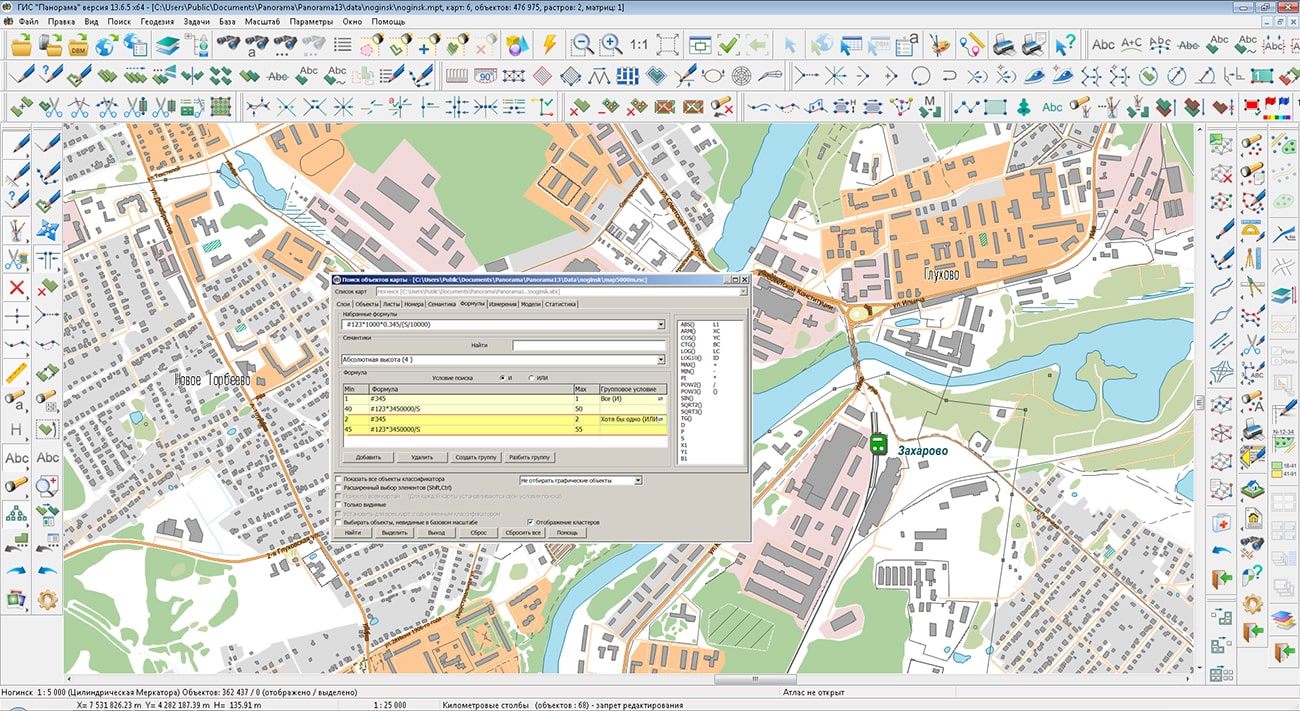
When searching and selecting objects on the map, the ability to group mathematical formulas for a combination of mathematical expressions and logical conditions has been added. For example, in the presence of semantics with the amount of saltpeter in tons applied to a given area, and semantics with the class of soil fertility, it is necessary to select areas where the amount of nitrogen per hectare is optimal. Let semantics 123 contain the amount of saltpeter applied to the area in tons, and semantics 345 contain the soil fertility class (from 1 to 6). Since the area of the plot (S) is calculated in square meters, and ammonium nitrate contains 34.5% of nitrogen, the formula for calculating the specific dose of nitrogen will look like: "#123*1000*0.345/ (S/10000)" or simplified "#123*3450000/S". For the first class of fertility, we set the first group of formulas: "#345" with boundary values 1 and 1 and "#123*3450000/S" with boundary values 40 and 50, for the second class the boundary values of the first formula are 2 and 2, the second 45 and 55 and so on. Within the group, select the logical "AND" condition - both formulas must meet the boundary conditions. We select the logical "OR" condition between the groups - although in one group the conditions must be fulfilled during the calculation. When you press the button, all areas where the nitrogen dose is optimal will be highlighted. The typed conditions can be saved in templates of search conditions under the specified names and applied as necessary.
In the "Geodesy editor" task, the modes of generating reports for preparing graphical applications for the forest declaration approved by order of the Ministry of Natural Resources and Environment of the Russian Federation dated July 30, 2020 N 539 were updated. Report templates for the forest declaration were updated, processing of new markers was added and the digital classifier of map forestry.v2 was improved, used to prepare maps of graphics application for forest declaration.
The modes "Reading the cadastral plan of the territory and updating the map" and "Create objects from XML file of the cadastre", which are part of the task "Cadastral documents", have been improved. The algorithm for reading data about the elements of the structures contour has been improved. If the contour of capital construction object (CCO) is represented by a set of elements of different types (point, line, arc, circle), then a set of objects of different localization (linear and point) is created on the map. For elements with the "circle" type, point objects are created that contain the radius value in the semantics. For elements "point", "line", "arch" the linear objects are created. As a result of loading, one CCO can be represented on the map by several objects of different localization with the same value of the "Cadastre number" semantics.
The new version of the program is available for download in the section.


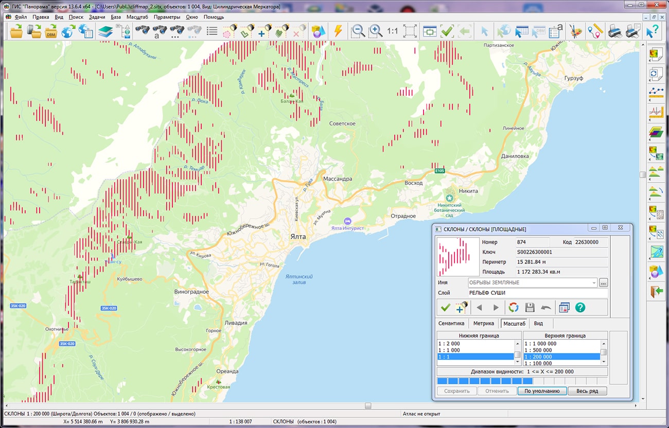
In KB "Panorama" the version 6.0.4 for the has been developed. In the new version of the program the mode "Creating contours for cliffs and rocks" has been implemented. It allows you to create polygonal objects for terrain areas where the slopes of the relief exceed the values specified by the operator.
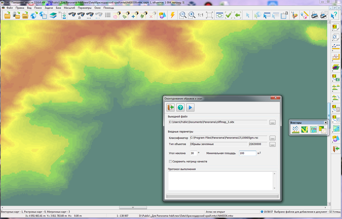
The contouring of and rocks is performed in an automatic mode. At the first stage by a matrix of heights of a relief the matrix of qualities is constructed containing two classes of values. The first class contains cells related to cliffs or rocks, and the second contains cells with normal terrain, displayed on the map by contours. Further the matrix of qualities is used for an automatic vectoring the borders of areas which are belonging to the class of cliffs and rocks. Mode "Creating contours for cliffs and rocks" provides accurate definition of the boundaries of polygonal objects, including those that cannot be determined using visual interpretation. Additional parametres of constructing allow to save a matrix of qualities and to filter out cliffs and rocks of the small area. The complex application of the modes "Formation of H coordinate of hydrographic objects", "Creation of horozontals by matrix of elevations", "Contouring of cliffs and rocks" and "Adjustment of isolines and linear hydrography objects" provides a high level of automation of the processes of creating information about the relief for topographic maps.
The software package is designed to solve a wide range of tasks for the creation and analysis of matrix data models, including the construction and processing of information about the terrain. The main source of data for modeling the terrain is the Earth's remote sensing materials. The complex technology of joint application of digital photogrammetric system PHOTOMOD and the GIS "Panorama" provides creation of the information about the terrain in the required volume and specified accuracy. As a result of photogrammetric processing of space and aerial photographs, clouds of three-dimensional points, triangulation models, elevation matrixes and orthophotomaps are obtained. To clarify the relief forms, vectorization of structural lines is performed in stereo mode.
Map editor in the GIS "Panorama" is intended for digitizing terrain objects from the orthophotomap image, and the 3D Analysis Complex provides a comprehensive development of various terrain models, including for three-dimensional visualization. The editor of a map in a GIS "Panorama" is intended for numbering of objects of district under the orthophotomap image, and the Complex 3D the analysis provides complex working off of various models of a relief, including for three-dimensional visualisation. At the same time, routine operations for digitizing contours and microforms of relief are performed automatically in streaming mode.
The new version of the program is available for download in the section.


In KB "Panorama" the version 13.6.4 has been developed. In the new version, loading of the pyramid of raster tiles from KMZ files has been added. KMZ archive can contain a KML file and a set of raster files. The KML file contains a description of parameters of the raster data - the names and coordinates of a binding of rasters, and also the priority of their drawing. As a result of importing a pyramid of raster tiles from KMZ, a set of RSW files is formed combined into an MPT project. The MPT project contains a list of RSW files and their visibility borders according to the "Draw Order" parameter. Loading a pyramid of raster tiles from KMZ files is implemented in the task of importing graphic files (GeoTIFF, PNG, JPEG and others).
In the task of of importing matrixes from SRTM, GeoTIFF formats, loading of the pyramid of matrixes of heights of a relief from KMZ format has been added. The KMZ archive contains a KML file and a set of single-channel GeoTIFF files with data on elevation heights, from which a set of MTW files is formed combined into an MPT project with specified matrix visibility borders in accordance with the "Draw Order" parameter.
Possibility has been implemented for displaying a packed project of spatial data MPTZ from the GIS Server of version 9.4 and higher. A packaged project may include a complex representation of the territory in the form of vector maps of different levels of detail, images of the terrain in RSW format, matrixes of heights and matrixes of quality characteristics of the terrain, insets from the same data, the reference to data from the GIS Server and from geoportals by various protocols. All data sets are packed into one file of MPTZ format. The total amount of packed data is reduced by 3-10 times. The speed of data exchange, packed into an MPTZ project, increases 5-20 times, taking into account the decrease in the number of transferred files. The size of the MPTZ file and the number of sets in the project are not limited. Maps are packed together with classifiers, a tree of distribution of objects over the map area, multiscale objects (generalized contours for different display scales) and hash tables indexed for search of objects semantics, pyramids of tiles, rasters and matrixes, which provides high speed of display and data search. The virtual folder on the GIS Server can be supplemented/updated by MPTZ projects in a background mode, changing the area and detail of the background cartographic coverage and the composition of remote sensing data without additional data administration. Packaged MPTZ projects can be formed by region (as, for example, on Digital maps page) or according to nomenclature sheets (for example, at a scale of 1: 500 000), which allows you to quickly form a complex coverage of a given territory.
The list of supported DBMS for work with spatial databases has been expanded: PostgreSQL with the PostGIS extension, Oracle with the Oracle Spatial or ArcSDE extension, Microsoft SQL Server. Parameters of connection to a database are customized in the administration dialog and saved in a file with the DBM extension, which has an XML structure. The settings provide for the choice of the method of connecting to the database, the creation of lists of displayed and edited objects and their semantic characteristics (attributes). GIS provides direct displaying and editing of arbitrary spatial databases in cartographic conventional symbols, including those created by other GIS, without additional third-party modules based on direct interaction with PostgreSQL, Oracle and MS SQL Server DBMS through SQL queries.
The search speed of objects with given semantic characteristics is increased by an average of 1000 times due to the indexing of semantics values using polynomial hashing methods, constructing values reference books and other improvements of search algorithms. On a test case of 4 000 000 objects, a search was performed using three indexed semantics: "Name", "Number of inhabitants", "Unique object identifier", which were filled in for more than 3 350 000 objects. The speed of performing sample of objects has decreased from 4 seconds to 4-5 milliseconds. The additional amount of RAM for placing the hash tables was 95 MB, the size of the source map was 802 MB. To activate the construction of hash tables, it is necessary to enable the "Index" option in the Classifier Editor for the semantics used when searching for objects. To reduce the time for building hash tables, they are saved into a file with the ".seh" extension and read when the map opening. When saving a map into the packed SITZ\MAPZ\MPTZ format, hash tables are packed in a common archive with the map. The new algorithm makes it possible to execute more requests on search from application tasks in multithreaded mode and improve the performance of server applications.
In the "Classifier Editor", the list of mathematical operations for describing the semantics-formula has been expanded. The value of such semantics is automatically calculated when updating the coordinates or semantics of the object and can participate in the formation of the conventional symbol of the object through a series of objects (a matrix of conventional symbols, depending on the combination of the semantics values) or based on programmable symbols.
For displaying polygons with a point symbol, a new object property has been added - "Polygon with a point". For objects with this property, when creating and editing an object, or when sorting, a subobject with one point in the center of the polygon is automatically created. If a conventional symbol of polygon contains polygon parameters and parameters of a point or vector symbol, the corresponding symbol will be displayed in the center of the polygon. The user can change the position of the point in the "Map Editor".
The new version of the program is available for download in the section.


Specialists of KB "Panorama" prepared and placed on the geoportal the maps of the Voronezh and Ivanovo regions. The maps were formed using OpenStreetMap data, source data was obtained from Geofabrik website. To work with the maps, you can use the program or other software products of KB "Panorama".
The maps were led to the modernised classifier of large-scale plans of scale 1: 5 000 (map5000m.rsc) and were saved into a packed project (MPTZ). The MPTZ format project includes a digital map of the region's territory (country, subject of the federation, administrative region), a map of the administrative-territorial division of the region and a digital classifier. Publishing of updates in bank of spatial data is made by using the program of . Publishing contents of bank of spatial data on the geoportal and data access for downloading are implemented by means of .
Free maps on the basis of OpenStreetMap data are available for download on the page "Digital maps".


Specialists of KB "Panorama" took part in the work of the military-scientific conference "Creation of a unified geoinformation space for ensuring the defense and security of the Russian Federation." The conference, organized by the Military Topographic Directorate of the General Staff of the Armed Forces of the Russian Federation, was attended by representatives of military command and control bodies, heads and specialists of Russian industry companies, representatives of military scientific organizations and universities.
The report "Application of "Panorama" technologies for constructing a single geoinformation space for defense of the Russian Federation" presents software products that ensure the construction of a distributed information system, in a complex using spatial data from various sources of information. The presentation shows the elements of realisation of the implemented information systems for managing the development of territories at the level of the constituent entities of the Russian Federation. Panorama software technologies are designed to solve a wide range of tasks based on client-server, cloud, mobile and Internet technologies. For more information, see the article.
All software is cross-platform and operates in operating systems of AstraLinux SE, Alt Linux, Zarya, CentOS, Red Hat, Debian, Fedora, QNX, MS Windows. The programs are compatible with various security tools (authorization tools, data encryption, antivirus, firewalls and others), support Intel, AMD, SPARC, MIPS, ARM, Elbrus processors. The Panorama software suite implements a geoinformation platform for creating various information systems, spatial data banks and automated control systems.
In the speeches of other conference participants, it was noted that in order to implement a single geoinformation space, it is necessary to switch to new principles of providing geospatial information based on network information resources, using geoservices and geoportals. To access the network information resources in a secure information transmission network according to uniform rules, it is necessary to create an automated control system that implements the principles of interoperability. Geoinformation tools of the developer the , and allow integrator companies that create automated control systems and other information systems to quickly and efficiently integrate tools for displaying and analyzing spatial data into their solutions.
The materials of the report on the use of "Panorama" technologies for the construction of a single geoinformation space for the defense of the Russian Federation are available for review in the "Presentation" section.


Ph.: +7 (495) 739-0245, +7 (925) 221-1603
www.gisinfo.ru | panorama@gisinfo.ru
105005, Russia, Moscow, Baumanskaya Street 7, building 1, office 229 (m. Baumanskaya)
Copyright © Panorama Group 1991 - 2024


 Mobile version
 Full version