Copyright © Panorama Group 1991 - 2024

In KB "Panorama" the version 13.0.7 has been developed for creating GIS applications in the environment of C++ Builder, Delphi Embarcadero. The new version provides processing of spatial data located in databases controlled by PostgreSQL DBMS with PostGIS extension. The attributive data about terrain objects are stored in a database in standard types of fields. The spatial data has type the geometry and can have various system of coordinates. Spatial data is displayed and edited in the form of vector maps in cartographical conventional symbols. Direct editing of database records with fields of various types containing the coordinates of objects is provided. To customize connection parameters in the GIS ToolKit a new TMapDbm component has been developed, which allows you to call the database connection administration dialog (table, data view or SQL query) and save them for further use in a file with the DBM extension, which has an XML structure. The settings include entering the name of the DBM file, the method and parameters of connecting to the database, creating lists of displayed and edited objects and their semantic characteristics (attributes). The installation includes examples of DBM files for connecting database tables. The toolkit allows you simultaneously to edit the contents of databases connected both directly (connecting directly to the DBMS) and through the GIS Server, to carry out an exchange of information between different databases, to conform the coordinates and attributes of objects in different databases, jointly to display information from different databases in the form of graphic layers data, to combine data with images, DEMs, vector maps and data from various geoportals and web services.
To work with databases in multi-user mode, into the TMapView, TMapScreen display components the ability has been added to automatically track changes that have occurred with a specified frequency (SetTimerAdjustData method). This possibility provides the display of mobile objects, the coordinates of which are stored in the database, against the background of other cartographic material.
Toolkit GIS ToolKit consists of a set visual a component (are delivered in initial texts) and АПИ functions of a GIS-kernel for direct access to the spatial data. The toolkit is intended for working out of client-server and desktop 32 and 64 digit appendices in which processing and visualisation of the spatial data is required. The spatial data can settle down as on a workplace (direct access to the data), and in a local network or a network the Internet (access components to a GIS to the Server or data exchange under the international reports are used).
The GIS ToolKit consists of a set of visual components (supplied in source code) and API functions of the GIS core for direct access to spatial data. The toolkit is intended for the development of client-server and desktop 32-bit and 64-bit applications that require processing and visualization of spatial data. Spatial data can be located both at the workplace (direct access to data), and in the local network or the Internet (components of access to the GIS Server or data exchange using international protocols are used).
The new version of the program is available for download on the page.


In KB "Panorama" the version 5.8.0 has been developed for operating systems Astra Linux, Windows, CentOS. The program has been supplemented with project the 3D maps "". The project includes maps of the Republic of Crimea and Krasnodar Territory. Maps include objects of hydrography, vegetation, road net, objects of an infrastructure and operational situation. 3D-models of sights and outstanding objects of Novorossisk, Kerch, Anapa, Gelendzhik and other cities are used. In the area of the Crimean bridge, a scenario of the movement of transport and ships is demonstrated. In a 3D map a diagnostics has been added at data obtaining. Into the log of map events the messages are given when there are errors in the settings for displaying 3D objects.
In the Layer Objects component a possibility of displaying semantics by settings was added. Modes the Map Editor and Print have been updated. In the administration module, the user interface settings have been extended.
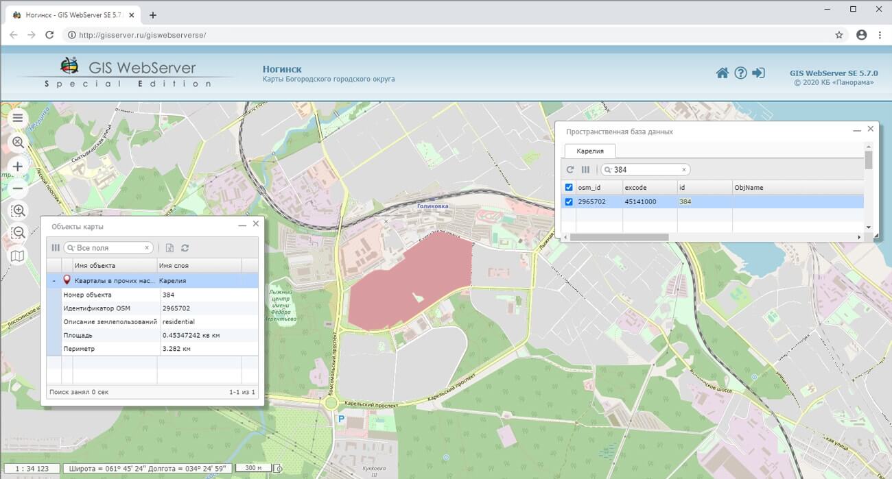
In the new version, the Web application development toolkit is enhanced, which extends the capabilities of GIS WebServer SE and can be integrated into other information systems. Access to data (images, vector maps, and terrain information) is provided by Web services using generally accepted OGC protocols and ISO standards. The GIS WebService SE service (OGC WMS/WMTS) provides spatial information in the form of graphic images. As a digital terrain model, various types of elevation data are used: matrixes (in SRTM, GeoTIFF, IMG, MTW formats), TIN-models, point cloud and others. The service provides the ability to publish three-dimensional terrain models unloaded in DB3D format. These models can be obtained from files of the COLLADA type, as well as from photorealistic three-dimensional models of unlimited size (TLS, OC3).
As a source of spatial data, the can be used. It provides the collection, storage, search and delivery of spatial data in exchange formats, displaying the state of the data bank in the form of maps-schemes, and the automated formation and updating of geo-covers.
is used in the construction of closed corporate systems to ensure the protection of data having a security classification or a trade secret. GIS WebServer SE is certified for Level 2 of absence of undeclared capabilities. The new version of the program expands the application's capabilities in solving problems of analysis, management and long-term planning of the territories development. GIS WebServer SE is implemented using the toolkit of GIS WebToolKit SE, which can be used in development tools that use the JavaScript.
The new version of the program is available on the website in the section.


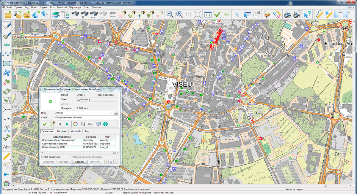
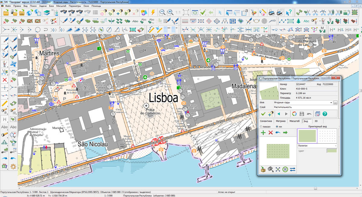
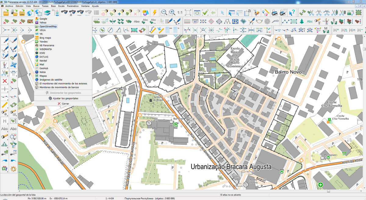
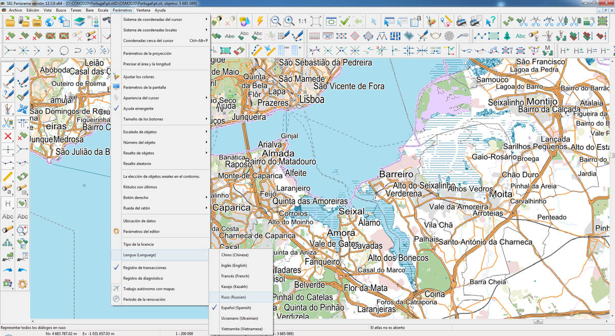
The geoportal has been supplemented with a map of the Portuguese Republic, formed according to OpenStreetMap data. Source data obtained from website. To work with the map, you can use the program or other software products of KB "Panorama".
The map was led to the modernised classifier of large-scale plans of scale 1: 5 000 (). Publishing of updates in bank of spatial data is made by using the program of . Publishing contents of bank of spatial data on the geoportal and data access for downloading are implemented by means of .
Free maps on the basis of OpenStreetMap data are available for download on the page .


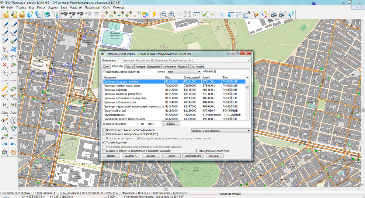
The geoportal has been supplemented with a map of the Hellenic Republic, formed according to OpenStreetMap data. Source data obtained from website. To work with the map, you can use the program or other software products of KB "Panorama".
The map was led to the modernised classifier of large-scale plans of scale 1: 5 000 (). Publishing of updates in bank of spatial data is made by using the program of . Publishing contents of bank of spatial data on the geoportal and data access for downloading are implemented by means of .
Free maps on the basis of OpenStreetMap data are available for download on the page "Digital maps".


In KB "Panorama" the version 13.2 has been developed for OS Astra Linux SE and OS Zarya. The new version is built on a multi-platform multithreaded core for Linux, QNX, Android, MS Windows with support for Intel/AMD, Elbrus, ARM, PowerPC, SPARC, MIPS and others processors. To improve the reliability of the software, numerous automated functional tests have been developed, the code has been optimized using text analyzers and performance evaluation on a multi-core architecture. The list of types of processed data has been expanded: data from geoportals, multidimensional databases, pyramids of tiles BIR, GPKG, multiscale packed maps MAPZ, MPTZ and others. The new version of the GIS "Operator" SE is submitted on certification in the certification system for information security requirements by the 2nd level of undeclared possibilities.
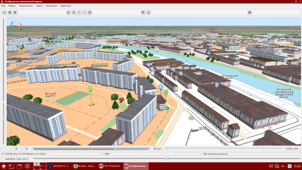
In the "Navigator 3D" task, the list of formats of imported models for displaying accurate and realistic tiled 3D terrain models has been expanded. Support was added for import of models from the OBJ format into a database of three-dimensional models of DB3D format. Operator.p3d library of three-dimensional symbols of operator.rsc classifier has been improved. There are added the simplified models of Russian military equipment for displaying at distances far from the observer. This approach increases the speed of displaying a three-dimensional terrain model on maps of the operational situation with a large amount of equipment. Thus the nearest view of models remains detailed, corresponding to specific types of weapons. The operator.rsc classifier provides preparation of special maps for all types and branches of the RF Armed Forces.
The algorithm for generating the titles to objects on a three-dimensional terrain model has been improved. Creation of 3D-titles is carried out by means of fonts in format SDF (Signed Distance Field). The use of SDF fonts allows accelerating the display of a three-dimensional terrain model by using a single texture with a symbols atlas when creating titles for objects and provides a better visual perception of the text. Thanks to automatic smoothing of symbols borders the text, created with the new technology is free from the disadvantage of jagging along the edges of symbols, and remains visually smooth at rotating and scaling in wide ranges. This increases the readability of the titles and makes working with the 3D model more convenient.
Support was added of the multiscale objects having the several copies of a contour with different details of points. Additional contours are formed for smaller scales of display - 1/4 1/16, 1/64 from base scale of a map and are recorded into the object metrics together with the main contour. When compressing the map, those contours of objects that are closer to the current display scale will be automatically displayed. This speeds up the display of complex objects and makes the image of the terrain more visual. At any editing of the map and when performing calculations by the metric of the object, the main contour of the multiscale object is processed. Objects are one of the elements of a multiscale map that changes its view when changing the display scale. Application of multiscale maps in packed MPTZ project allows to reduce number of created scales (layers) of maps in system of storage, finishing and application of topographic and geodetic information.
The appearance of the dialogs "Create map", "View Passport", "Standard transformation", "Data list", "Import from KML", "Import from SHP" has been improved. In the "Save as ..." mode, the ability of saving in MPTZ format has been added. In the task "Map Editor" the ability was added to customize the number of active models and created symbols.
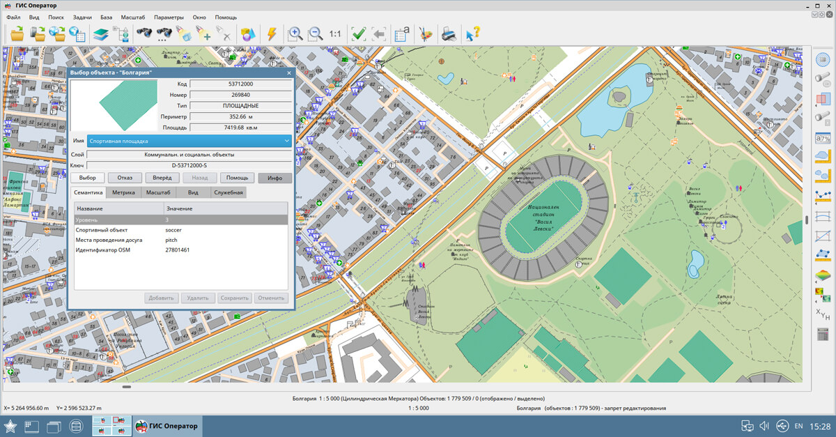
GIS "Operator" SE is a universal domestic geographic information system for power structures. The program is intended for accumulation, the storage, the automated processing and displaying the data, results of calculations and the forecasts having a geospatial binding. GIS "Operator" contains tools for displaying and processing vector, raster and matrix maps. The application provides users with tools for solving specialized tasks of modeling the movement of special objects against the background of 3D model, a forecasting the consequences of emergencies on hazardous objects, a monitoring the movement of aircraft, a performing the geodetic and topographic work, processing data from GPS/GLONASS navigation devices, a printing the displayed spatial data to various output devices and many others.
The new version of the program is available for download in the .


Ph.: +7 (495) 739-0245, +7 (925) 221-1603
www.gisinfo.ru | panorama@gisinfo.ru
105005, Russia, Moscow, Baumanskaya Street 7, building 1, office 229 (m. Baumanskaya)
Copyright © Panorama Group 1991 - 2024


 Mobile version
 Full version