Copyright © Panorama Group 1991 - 2024

MIIGAiK and KB "Panorama" provide the work of the scientific-discussion student club of the CIS countries. Young specialists in the field of geoinformatics conduct research on the topic: . The task of the club members is to practically explore the possibilities of using open geodata and software of KB "Panorama" in a number of areas. These areas include:
- search on the Internet of open spatial data (digital maps, space and aerial photographs, elevation matrixes and others) and study of mechanisms for using geodata in GIS;
- assessment of the accuracy of open geodata from various sources;
assessment of the possibility of using open data to solve various applied problems of commercial, municipal or state administration;
- development and testing of software technologies for the use of open spatial data for solving various industry problems (in-house cadastre, control of urban planning activities, monitoring of construction, assessment of investment attractiveness of territories, and others).
To conduct research, the participants use the software the , , and the developer's toolkit .


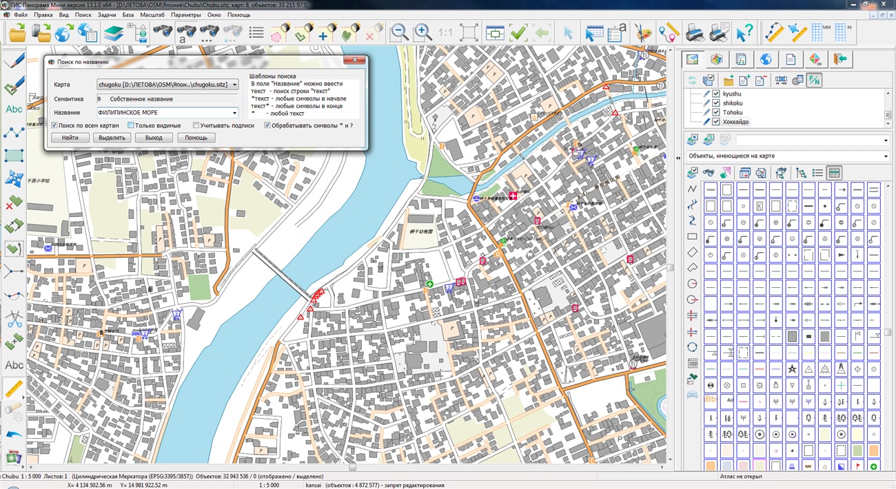
The geoportal has been supplemented with a map of Japan, formed according to OpenStreetMap data. Source data obtained from website. The composition includes 8 regions: Chubu, Chugoku, Kansai, Kanto, Kyushu, Shikoku, Tohoku, Hokkaido. To work with the map, you can use the GIS Panorama Mini program or other software products of KB "Panorama".
The map was led to the modernised classifier of large-scale plans of scale 1: 5 000 (map5000m.rsc). Publishing of updates in bank of spatial data is made by using the program of . Publishing contents of bank of spatial data on the geoportal and data access for downloading are implemented by means of .
Free maps on the basis of OpenStreetMap data are available for download on the page "Digital maps".


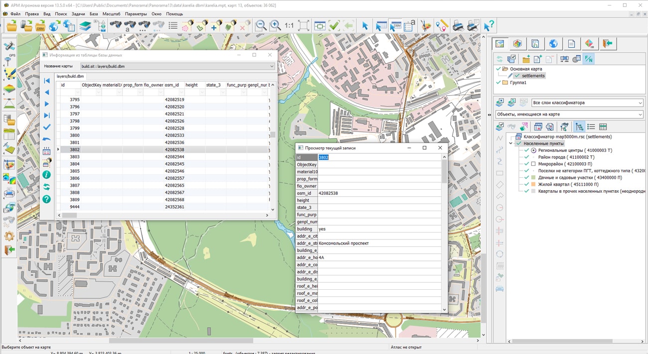
In KB "Panorama" the "Workstation of agronomist" version 13.5.0 has been developed. In the new version the tools have been implemented for input and editing of the metric and attributive description of contours borders of agricultural land with use of multiscale objects and storage of information in spatial databases. "Workstation of agronomist" is the automated workstation constructed on base of the GIS Panorama Mini and the additional module "Complex of agronomical tasks". "Workstation of agronomist" includes tools that allow you to create and edit electronic maps of fields, maintain a land corded book, to work with agrochemical and satellite monitoring data, carry out thematic mapping and generate reports using customizable templates.
The new version of "Workstation of agronomist" provides storage of description of spatial objects in a database under the control of the PostgreSQL DBMS. Objects from a database are presented in the form of the table, each record of which is linked with the corresponding object on a map. There are available the new tools of search for object of a map for the current record, movement through records, editing of records, search, filtration and sorting of data. In the form of a separate table a viewing of the detailed information for current object is possible. Additionally, the interface allows displaying images and multi-line text in a separate screen form.
The program supports multiscale objects having several metric descriptions with different details of the borders of the agricultural land contour. An additional metric for smaller display scales is generated automatically by the generalization method. This approach significantly increases the speed of displaying objects with complex metrics and makes the map clearer when scaling on-screen.
Multiscale objects are the basis for creating multiscale maps that change their detail depending on the current scale. The use of such maps in a packed MPTZ project can reduce the number of created units of spatial information's storage.
A mechanism has been developed for drawing titles linked with map objects, which, when the map image is enlarged, are "pulled" to the object. The distance between the object and the title becomes up to two times less than when scaling without using this technique.
The possibility of multi-user work with access control through a connection to the allows you to create scalable distributed information systems. Conducting passports of fields is carried out in structure of information base the GIS "Panorama AGRO" that provides full compatibility and joint use of these products.
The new version of the program is available on the website in the section.


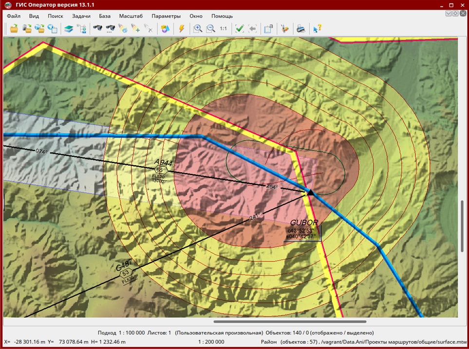
In KB "Panorama" the C version 7.4 has been developed for the version 13, OS Astra Linux SE (Release "Smolensk"). The new version allows to implement the analysis of areas for providing data about obstacles in areas of airdromes. Borders of areas are determined in accordance with the requirements of the Order of the Ministry of Transport of the Russian Federation dated October 31, 2014 № 305 "On approval of the Procedure for the development and rules for the provision of aeronautical information". The function of constructing a map of absolute heights is supplemented by the mode of building a map of the minimum safe sectors. The possibility of forming a buffer of waiting areas based on the "Hippodrome" schemes has been implemented. The mode of drawing a scheme of visual landing in a circle has been improved with the ability to add surfaces of visual landing (VSS). Into algorithms of surfaces analysis the possibility of scanning the digital terrain (matrix of heights) with extremums detection has been added. In the program the mode of constructing the borders of strips of air approaches has been implemented in accordance with the requirements of FAP-138, clause 23 and the order of the Ministry of Transport of the Russian Federation dated 04.05.2018 № 176 "On approval of the Procedure for establishing the borders of strips of air approaches at civil aviation aerodromes".
The complex of solving aeronautical tasks is intended for the creating and maintaining a database of aeronautical information, the formation of aeronautical maps, the designing of aircraft flight routes and the exchange of data with other information systems. The program allows to carry out calculations of flights routes, to analyze objects of airdrome and surrounding area for their impact on air traffic safety.
The main source of aeronautical information is the aeronautical data base created on the basis of the AICM (Aeronautical Information Conceptual Model), with additions for storing planned information and results of designing routes. The model is recommended by the "Eurocontrol" - international organization of planning and coordination of air traffic.
The new version of the program is available for download in the section.


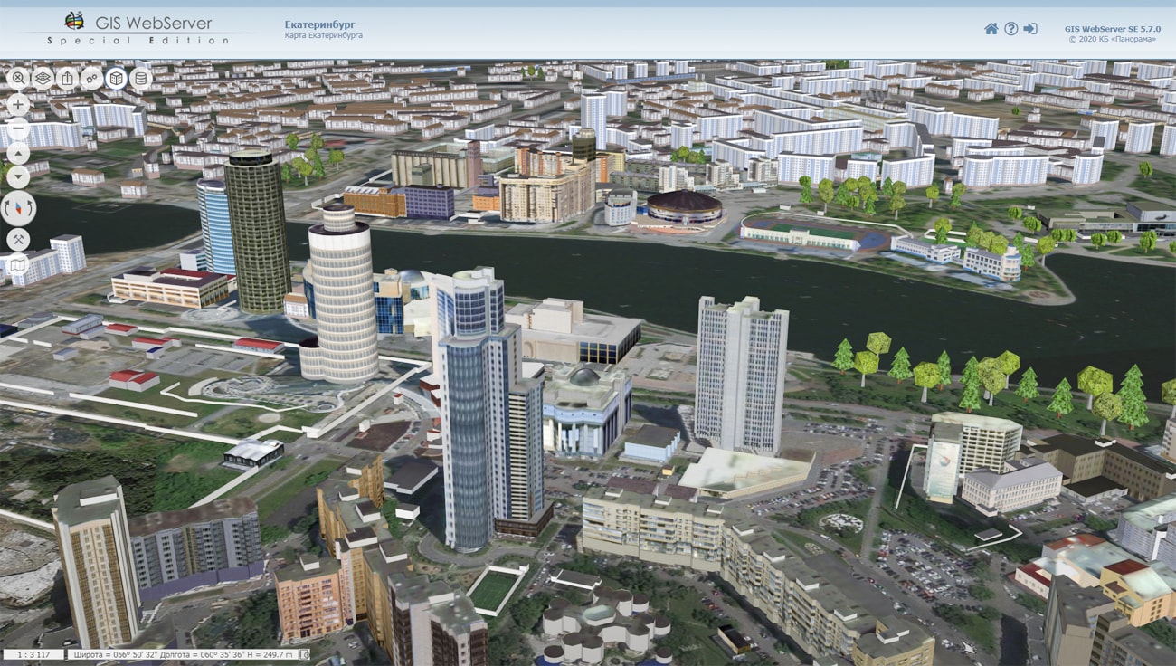
In KB "Panorama" the version 13.6.0 has been developed. In the new version a support of the automated dynamic updating the structure of digital representation of territory has been expanded. With the development of technologies of digitizing the economy and management systems, approaches to the digital representation of the territory are rapidly changing for different tasks. The composition of classified objects and their attributes, conventional symbols, distribution by layers and other properties are clarified.
For the continuous reliable operation of information systems, changes must be processed automatically with the update of transmission protocols, access rights, the structure of displayed data and their graphical representation. The logical structure of the digital representation of the territory is contained in the digital classifiers of vector layers created by types of economic activity and levels of territory management - urban planning, cadastral, logistics, communication, and so on.
When updating the content of the digital classifier, the GIS WebService SE can automatically update xsd-schemes describing the structure of published data and protocols for publishing information, the composition of the legend for interactive layer management and other settings. The scheme contains descriptions of layers, codes of objects, semantics and other metadata necessary for identification of objects on a layer. Dynamic and fixed schemes are supported. Fixed schemas are required for defining the non-automated rules.
The new version has improved the reliability of working with xml settings files included into the service. When editing setup files, a copy of the settings is generated. It will allow to avoid problems at an insufficient disk space. The service has added monitoring of free disk space for setup files, temporary data, event log, RAM. In case of lack of RAM or free space on the hard disk, or when the limit values are reached, the service informs the administrator about this.
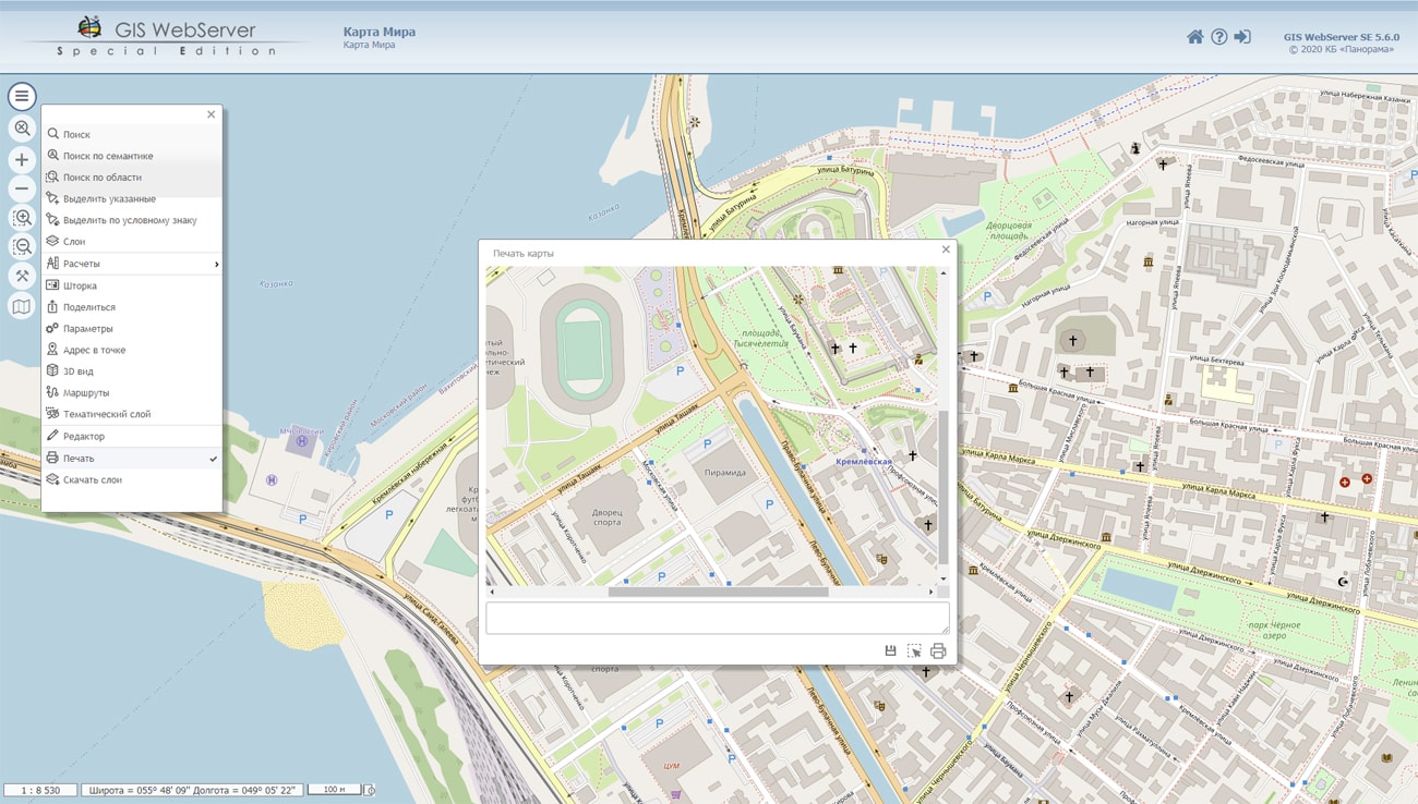
A new query has been added - displaying the connection parameters to the map, which is a database (dbm). The request for building thematic maps has been improved. Possibility of creating thematic maps by linear objects has been implemented. When forming a thematic map, information about an object (semantics, metrics) is fully saved. The request was added for calculation of the area of object taking into account the matrix of heights. In the program the diagnostic output of messages has been expanded.
The service supports distributed access to data based on REST requests. All requests are divided into 16 groups. Access to each group of requests can be set in the users.xml setup file. It is now possible to restrict the user by the scale of the viewed data, editing, searching, copying data, executing spatial requests, and much more. Names of groups correspond to documentation sections to the service.
GIS WebService SE supports all international standards (OGC WFS, WFS-T, WMS, WMTS, WCS), which are used to transfer and display spatial data. The program implements the ability to issue tiles for any user or local coordinate system. The application is implemented on Windows and Linux platforms and is compatible with Apache, IIS and nginx web servers.
The new version of the program and documentation are posted on the website in the section.


Ph.: +7 (495) 739-0245, +7 (925) 221-1603
www.gisinfo.ru | panorama@gisinfo.ru
105005, Russia, Moscow, Baumanskaya Street 7, building 1, office 229 (m. Baumanskaya)
Copyright © Panorama Group 1991 - 2024


 Mobile version
 Full version