Copyright © Panorama Group 1991 - 2024

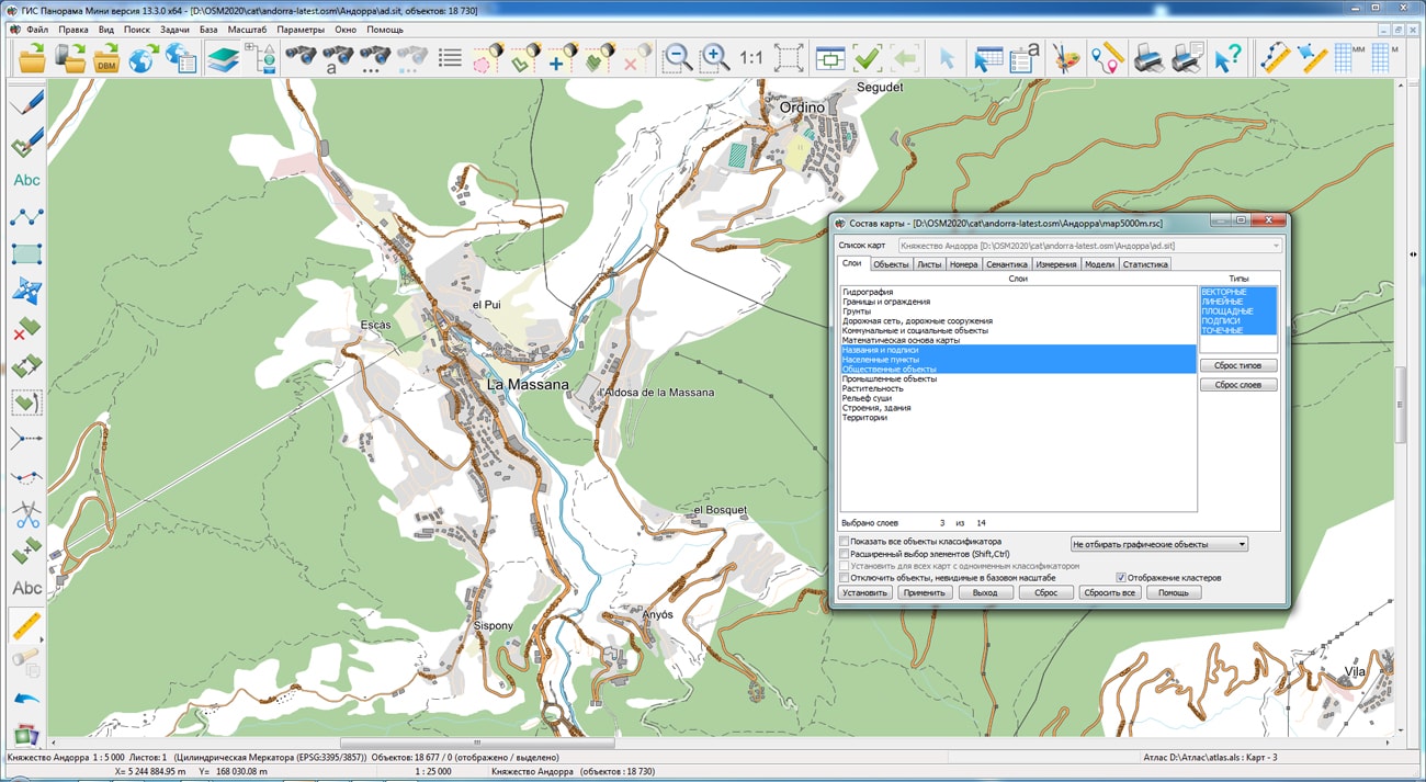
The geoportal has been supplemented with a map of the Principality of Andorra, formed according to OpenStreetMap data. Source data obtained from website. To work with the map, you can use the program or other software products of KB "Panorama".
The map was led to the modernised classifier of large-scale plans of scale 1: 5 000 (map5000m.rsc). Publishing of updates in bank of spatial data is made by using the program of . Publishing contents of bank of spatial data on the geoportal and data access for downloading are implemented by means of .
Free maps on the basis of OpenStreetMap data are available for download on the page "Digital maps".


In KB "Panorama" the "Workstation of cadastral engineer" version 13.5.0 has been developed. In the new version for processing cadastral information provided in the form of electronic XML documents from the EGRN, the algorithm for reading data and updating the cadastral map has been changed. The updates are aimed at improving the identification of cadastral objects and increasing the speed of data processing when updating an existing map. Controls were added for updating the cadastral map, including: updating, replacing and adding objects. When updating, a search for existing objects is performed and their metrics and semantics are updated with up-to-date information. When replacing, the map is cleared and filled with new relevant data. When adding to existing objects, new actual data are added.
Storage and collective use of the cadastral map located in a relational DBMS is supported. For providing access to contents of spatial databases (DB) the mode "Open a map DBM" is intended. To display spatial data (table, view or the result of an SQL query) in the form of a cartographic image, a file of DBM format is used, which contains a description of the parameters of a digital map.
In EGRN for identifying external contours of a multi-contour land plot, the cadastral number of the land plot and registration number of a contour are provided, and for zones and borders, the designations of external contours are not provided. This feature does not allow correctly to set a correspondence between objects that characterize external contours on the updated map and information in the XML file. The new version of the program implements an algorithm for identifying multi-contour cadastral objects for land plots, territorial and special zones, boundaries of territories and natural objects with automatic generation of the registration number of the outer contour. Indexing of objects of the updated map by identification data (cadastral or registration number and registration number of the contour) has been implemented. Map indexation increases speed of searching existing objects for their updating, especially at updating the map containing more than a hundred thousand objects.
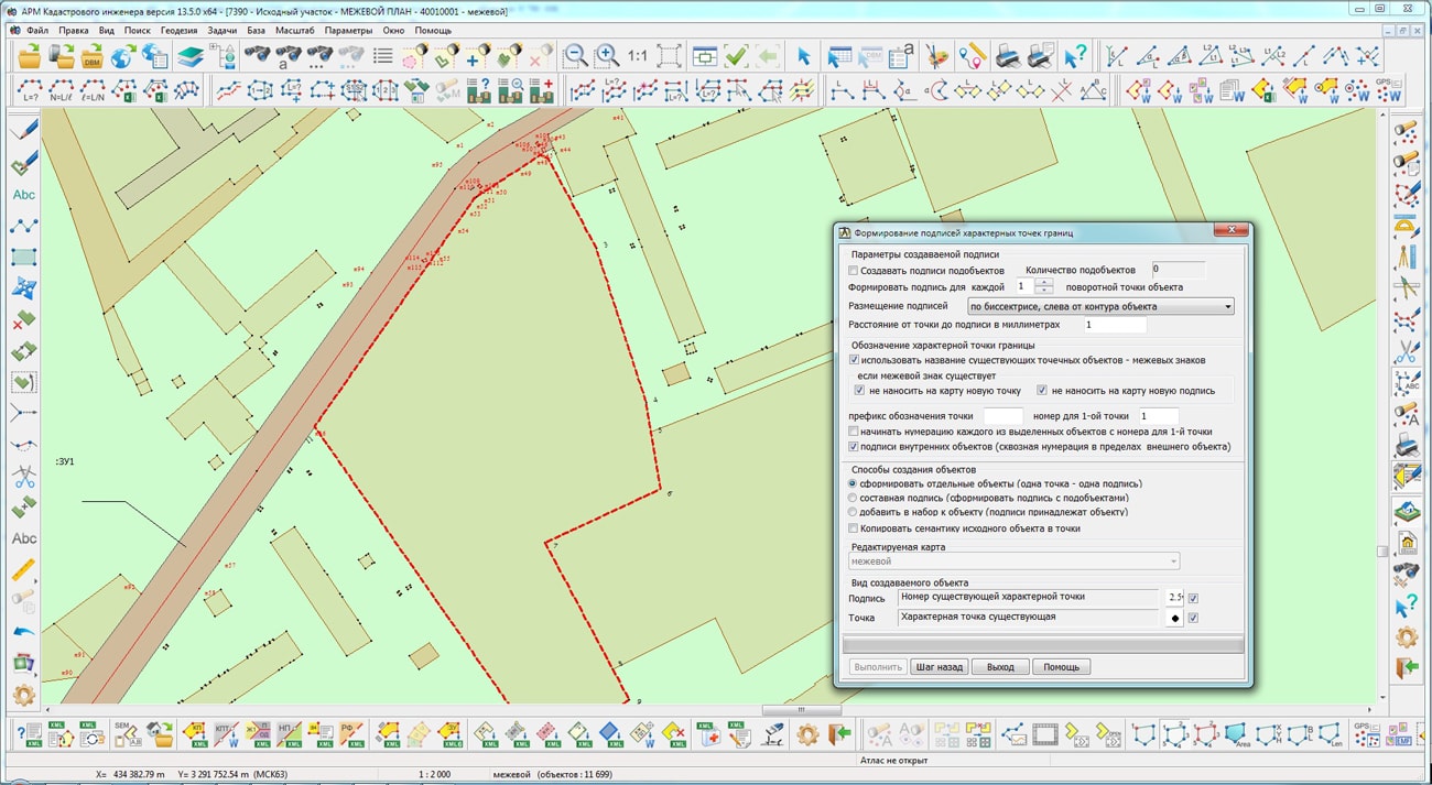
New possibilities have been added in the dialog "Forming the signatures of characteristic points of borders". To identify characteristic points of borders, a copying of the semantics values of the initial cadastral objects into the semantics of the points has been implemented. For variability of placing the signatures of the created dot signs characterising borders of cadastral objects, formation of signatures vertically and along a bisector of angle of adjacent metrics segments of initial object is provided.
The new version of the program is available on the website in the Download section.


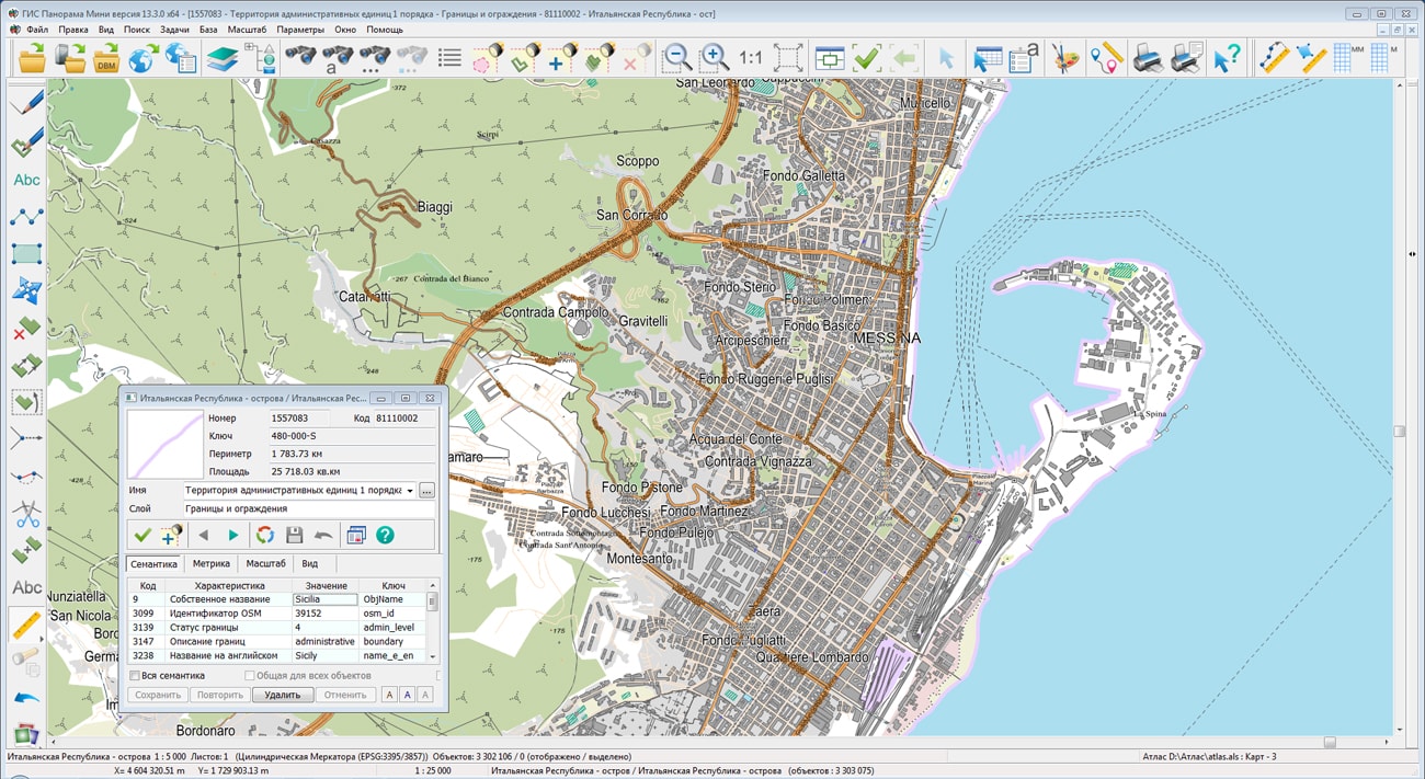
The geoportal has been supplemented with a map of the Italian Republic, formed according to OpenStreetMap data. Source data obtained from website. The composition includes 5 territories: Islands, the Northeast, the Northwest, the Center and the South. To work with maps, you can use the program or other software products of KB "Panorama".
The map was led to the modernised classifier of large-scale plans of scale 1: 5 000 (map5000m.rsc). Publishing of updates in bank of spatial data is made by using the program of . Publishing contents of bank of spatial data on the geoportal and data access for downloading are implemented by means of .
Free maps on the basis of OpenStreetMap data are available for download on the page "Digital maps".


In KB "Panorama" the version 13.5.0 has been developed. In the new version of the program the complex of automated generalization of digital topographic maps of scales from 1: 25 000 to 1: 100 000 has been improved. In the mode of relief generalization, the quality of building the overlap matrix of contour lines has been improved, which is used to automatically generate additional contours. Additional contours are saved in areas free from overlapping the nearby contours. There is added an automatic increase in the area of small closed contour lines of hill tops that have elevation marks inside the areas bounded by small contours. In the mode of generalization of areal hydrography, the quality of automatic transformation of fragments of areal rivers into linear ones and the quality of matching new linear rivers with areal vegetation and soils have been improved.
Support was added of the multiscale objects having the several copies of a contour with different details of points. Additional contours are formed for smaller scales of display - 1/4 1/16, 1/64 from base scale of a map and are recorded into the object metrics together with the main contour. When compressing the map, those contours of objects that are closer to the current display scale will be automatically displayed. This speeds up the display of complex objects and makes the image of the terrain more visual. At any editing of the map and when performing calculations by the metric of the object, the main contour of the multiscale object is processed.
Multiscale objects are formed in the Map Sorting procedure. If for sorting the option of Generalization of multiscale objects has been selected, then for the objects of classifier RSC that have the Multiscale property, additional contours by a generalisation method will be built. Multiscale objects are one of the elements of a multiscale map that changes its view when changing the display scale. Application of multiscale maps in packed MPTZ project allows to reduce number of created scales (layers) of maps in system of storage, finishing and application of topographic and geodetic information.
Support has been added for drawing the titles linked with objects of a map, which at increase in the image of a map are pulled to the object. To do this, after entering the title text, you must place the cursor on the conditional binding point of the title and press CTRL + space, then move the cursor to the first point of the title placement and press the left mouse button. If the title is not horizontal then it is necessary to enter the second point to indicate the direction of the title placement. At increasing the image of a map the point of the title placement will be pulled to a binding point - the distance between them will be approximately in 1,5 - 2 times less, than at scaling the title without a binding.
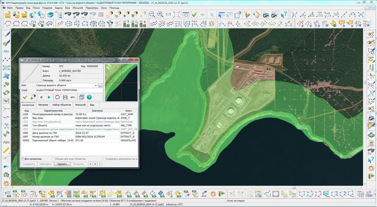
The block of geodesy and cadastral tasks has been improved. The mode "Reading the cadastral plan of the territory and updating the map" supports the XML-scheme extract_about_zones_v01 - an extract about zone. The list of conventional symbols for displaying cadastral objects characterizing the boundaries of a water object has been expanded. A linear object "WATER OBJECT ZONE" has been added into the survey.v5.rsc classifier to describe coastlines of reservoirs, large lakes, seas and other water objects, the border of which is not completely described, but in the form of separate fragments. The algorithm for reading spatial data for discrete cadastral objects has been updated. If there is information about the radius, the object of real estate is created a point one based on the coordinates of the center. In this case, the radius value is written into the semantics of the object. Collective use of "Base of cadastral works" of SQLite format was implemented, which contains information about cadastral engineers, contracts on execution of works, customers of cadastral works and other information. In program options the possibility has been added to choose the location of the file «Base of cadastral works» when network access. For convenience of identifying the information in headings of dialogs for working with "Base of cadastral works" the path to the database file is displayed. The mode "Editing attributes of a cadastral object" has been improved. The exchange of information about points of the reference boundary network with the dialog "Land Survey plan" has been implemented. In addition to information on the geodetic basis, there is provided an exchange of information about the list of documents used in the preparation of the survey plan and on the initial parts of the land plot.
The "View map control log" dialog called in the "Map Editor" task has been improved. There is simplified a work with message protocols generated for several maps by the task "Checking of adjacent sheets objects". Into dialog of viewing the results of control a possibility of a choosing a map from the list has been added. The list contains only those maps for which a message log has been generated.


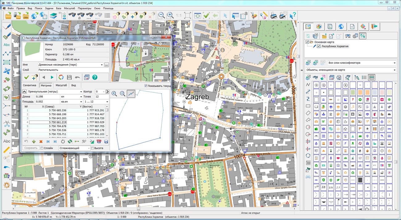
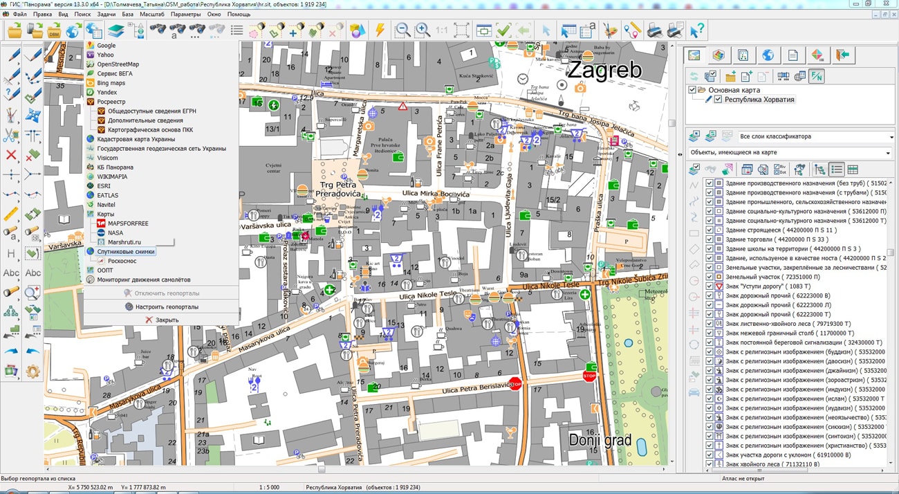
On the geoportal "Bank of spatial data", the map of the Republic of Croatia, formed according to OpenStreetMap data, has been updated. Source data were obtained from Geofabrik website. For work with a map it is possible to use the GIS Panorama Mini program or other software products of KB "Panorama".
The map was led to the modernised classifier of large-scale plans of scale 1: 5 000 (map5000m.rsc). Publishing of updates in bank of spatial data is made by using the program of Databank of digital maps and remote sensing data. Publishing contents of bank of spatial data on the geoportal and data access for downloading are implemented by means of GIS WebServer SE.
Free maps on the basis of OpenStreetMap data are available for download on the page "Digital maps and images".

Ph.: +7 (495) 739-0245, +7 (925) 221-1603
www.gisinfo.ru | panorama@gisinfo.ru
105005, Russia, Moscow, Baumanskaya Street 7, building 1, office 229 (m. Baumanskaya)
Copyright © Panorama Group 1991 - 2024


 Mobile version
 Full version