Copyright © Panorama Group 1991 - 2024

In KB "Panorama" the version 5.4 has been developed for operating systems Astra Linux, Windows, CentOS. In the new version, the data protection tools are expanded - a support was added for authorized access to data layers hosted on servers with PAM authentication. At the beginning of the session, the user must undergo additional authentication of the web server in order to obtain privileges for receiving geodata. Managing the contents of displayed objects in wms-layers has been added. To control the contents of the display, a filter by the keys of xsd-scheme objects is used. The filter is formed according to the legend of the map layer in the "Layers" tool. In the "Map Editor" a customizing the list of objects in the "View" panel appeared. It allows you to display a shortened list of layer objects using a filter by object type, code, and type of map object. Lists are saved between user sessions. Possibility to place map controls in the side panel is added. The side panel is located to the left of the map and provides a convenient interface at management of tools. In a 3D map, it has become possible to measure distances and difference of heights between two points of a three-dimensional model. Into the administration module a customization of parameters for data acquisition from servers with check of authenticity PAM has been added.
In the new version the toolkit of working out of Web-appendices which expands possibilities GIS WebServer SE is finished and can be built in other information systems. Access to the data (to pictures, vector maps and the information on a lay of land) is given by Web-services under the standard reports OGC and standards ISO. Service GIS WebService SE (OGC WMS/WMTS) gives the spatial information in the form of graphic representations. As digital model of a relief various kinds of the high-rise data are used: matrixes (in formats SRTM, GeoTIFF, IMG, MTW), TIN-models, a cloud of points and others. Cервис gives possibility of the publication of three-dimensional models of the district unloaded in format DB3D. The given models can be received from files of type COLLADA, and also from photorealistic three-dimensional models beyond all bounds the big size (TLS, OC3).
In the new version, the GIS WebToolKit SE Web application development toolkit has been improved, which extends the capabilities of GIS WebServer SE and can be integrated into other information systems. Access to data (images, vector maps, and terrain information) is provided by Web services using generally accepted OGC protocols and ISO standards. The GIS WebService SE service (OGC WMS / WMTS) provides spatial information in the form of graphic images. As a digital elevation model, various types of elevation data are used: matrices (in SRTM, GeoTIFF, IMG, MTW formats), TIN-models, point cloud and others. The service provides the ability to publish three-dimensional terrain models uploaded in DB3D format. These models can be obtained from files of the COLLADA type, as well as from photorealistic three-dimensional models of unlimited size (TLS, OC3).
In the new version there is improved the toolkit of Web-application development the GIS WebToolKit SE, which extends the possibilities of GIS WebServer SE and can be integrated into other information systems. Access to data (images, vector maps, and terrain information) is provided by Web services using generally accepted OGC protocols and ISO standards. GIS WebService SE (OGC WMS / WMTS) provides spatial information in the form of graphic images. As a digital elevation model, various types of elevation data are used: matrixes (in SRTM, GeoTIFF, IMG, MTW formats), TIN-models, point cloud, and others. The service provides possibility of publishing the three-dimensional terrain models unloaded into DB3D format. These models can be obtained from files of the COLLADA type, as well as from photorealistic three-dimensional models of unlimited size (TLS, OC3).
As a source of spatial data, the can be used. It provides the collection, storage, search and delivery of spatial data in exchange formats, displaying the state of the data bank in the form of maps-schemes, and the automated formation and updating of geo-covers.
GIS WebServer SE is used in the construction of closed corporate systems to ensure the protection of data having a security classification or a trade secret. GIS WebServer SE is certified for Level 2 of absence of undeclared capabilities. The new version of the program expands the application's capabilities in solving problems of analysis, management and long-term planning of the territories development. GIS WebServer SE is implemented using the toolkit of GIS WebToolKit SE, which can be used in development tools that use the JavaScript.
The new version of the program is available on the website in the section.


Specialists of KB "Panorama" prepared a presentation "Use of GIS "Panorama" in urban planning activity". It presents the city-planning geo-information system "Panorama GRAD", which combines the technology of automated preparing documentation and analytical tools to support the adoption of managerial decisions of municipalities and public authorities regarding the development of territories and the formation of a comfortable living environment. The system is built on the basis of geographic information technologies, which provides automated preparation of maps and plans, geo-referencing of documents to the map and a visual displaying the current situation of urban development.
The introduction of "Panorama GRAD" allows municipalities and public authorities to organize a unified environment for working with spatial data, attributive information and electronic documents. Due to the maintenance of automated ISOGD and systematized databases and information on urban development activities, employees of the municipality will always be provided with reliable information about the current state of the managed territories. The system allows you to publish open data on the Internet using the geoportal, which also helps to receive applications for obtaining the information from ISOGD. In the desktop application the system allows you to generate territorial planning documents and all types of urban planning documentation: urban development plan of a land plot, building permit, and others. System's tools provide maintenance of accounting registers: register of land plots, objects of capital construction and others.
"Panorama GRAD" is integrated with any information system of a city or region, which improves the quality of interagency cooperation, as well as the speed and level of service. In addition, integration allows to conduct operational control of departments according to carried out functions and areas of responsibility.
You can familiarize yourself with the urban development management system and presentation materials in detail on the "Presentations" page.


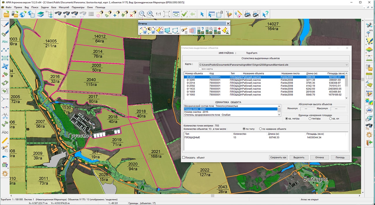
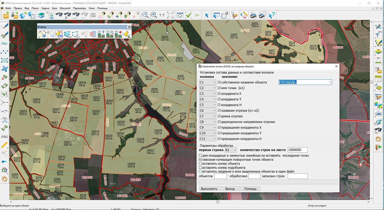
In KB "Panorama" the "Workstation of agronomist" version 13.2.0 has been developed. In the new version the technology of inventory and monitoring of agricultural land is implemented. It is intended for the specifying and displaying on a digital map of agricultural land, land reclamation objects, road network, buildings and structures, as well as land boundaries in the context of land users. To set the boundaries of land use, "Workstation of the agronomist" is supplemented with new modes "Create multipolygon", "Filling the report under the metrics of object" and "Copy objects to another map". The creation of multipolygons provides for the formation of multi-contour land uses consisting of several external and internal polygons - subobjects. Using this mode, one object can be formed including all the contours of one crop rotation field or land belonging to one land user.
"Workstation of agronomist" is integrated with the satellite monitoring service of Geosys company, which provides remote processing and analysis of large volumes of images posted on servers in the data cloud of various space data operators. Based on the results of queries, matrixes of vegetation indices and zoning maps are generated. Sorting data by measurement time allows you to build a slice of information about the condition of crops, vegetation of crops, heterogeneity of arable land and other indicators of land use. Using visualization tools, you can view matrixes of various indicators and graphs of their changes. The storage and processing of matrixes and time series for agrochemical indicators, vegetation indices, crop yields, phytosanitary indicators, meteorological data and other monitoring indicators is supported.
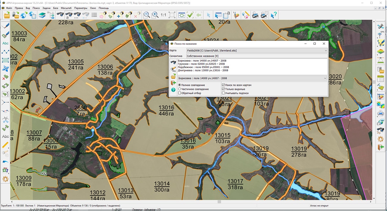
The technology provides the use for the inventory of data of operational space shooting of Earth's remote sensing satellites in combination with materials of shooting from unmanned aerial vehicles. The refined dialog "Select Object" provides an operational update of the object metrics from file formats: SHP/DBF, OGC GML, GeoJSON. To speed up the viewing of information from the semantics of objects, a new method has been added for selecting areal objects on the map, which ensures the selection of the desired object according to its contour, without enumerating all the objects at the map point. The task "Search by name" has been improved, the ability of searching and marking the objects by a list of lines that partially or fully match the value of a specified semantics or title text has been added. The list of lines can be loaded from a text file, pasted from the clipboard, or entered in the corresponding dialog box. The restriction on the text size of a multi-line title on the map is excluded.
The new version of the program is available on the website in the Download section.


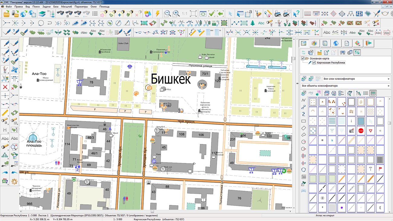
On the geoportal , the map of the Kyrgyz Republic, formed according to OpenStreetMap data, was updated. The source data was obtained from the website. For work with the map it is possible to use the program of or other software products of KB "Panorama".
The map was led to the modernised classifier of large-scale plans of scale 1: 5 000 (map5000m.rsc). Publishing of updates in bank of spatial data is made by using the program of . Publishing contents of bank of spatial data on the geoportal and data access for downloading are implemented by means of .
Free maps on the basis of OpenStreetMap data are available for download on the page "Digital maps and images".


In KB "Panorama" the version 13.3.1 has been developed. The new version adds support for international standards OGC 05-078r4 v.1.1.0 and OGC 02-070 v.1.0.0 - SLD (Styled Layer Descriptor). SLD styles allow you to dynamically change the image for a specific user without changing the classifier. Filters and styles of objects can be applied in requests on thematic mapping. Styles can be preloaded onto the service and attached to a specific layer or can be sent in a request. It is possible to display the same object in different ways, using the preset styles or sending your own. To each type of object specified by the key, its own SLD scheme can be assigned. The layer structure can be obtained using the DescribeFeatureType query. The transfer of the SLD scheme in the request for the creation of an object allows you to create graphic objects on the map, the symbol of which does not depend on the map classifier. The service also allows you to issue a graphical description of the objects (external view) in accordance with the SLD or in the format for Leaflet.
Support of international standard OGC 09-026r1 and ISO/DIS 19143 v.2.0 is implemented. This standard allows you to select objects according to the conditions specified in the request. For service's work in accordance with this specification the filter of objects is attached to the GetFeature request using the POST method. Support for the POST method for international standards OGC WMS and OGC WFS has been added. This will simplify the process of integrating the service with third-party software.
Possibility of gathering and displaying the statistical information about work of the service is added. For example, you can request the number of requests processed by the service per second, per minute, per hour; number of erroneous requests; the number of requests with a long processing time; average, minimum and maximum execution time of the selected request. The service groups the requests by types in accordance with the documentation (overlay operations, service operations, and others). The program allows you to display statistics for each group separately. In addition, you can display a list of active users and a list of active data. The administrator can monitor the load on the service and view its current status. Reliability of working the service is improved at occurrence of critical situations. Possibility of saving a stack of procedure call and current requests is added at abnormal termination of service's work.
Possibilities of work with 3D map are expanded. A new type of service has been added - Layers3D. This type combines all the possibilities of working with a three-dimensional terrain model and allows you to perform new requests. The list of displayed service types in the GetLayers request has been expanded. Support for scenarios of moving objects was added. The service allows issuing scripts for objects in the XML and JSON format, and also the trajectories of the objects movement. Using scripts, it is possible to simulate the movement of objects on a map. Support of maps in format SITZ has been implemented. New parameters for GetFeature requests have been added - do not display the value of heights, hide the output of metadata about the layer.
GIS WebServiсe SE supports all international standards (OGC WFS, WFS-T, WMS, WMTS, WCS), with the help of which the transmission and display of spatial data is carried out. The program implements the ability to issue tiles on any user or local coordinate system. The application is implemented on Windows and Linux platforms, is compatible with Apache, IIS and nginx web servers.
The new version of the program and documentation are available on the website in the section.


Ph.: +7 (495) 739-0245, +7 (925) 221-1603
www.gisinfo.ru | panorama@gisinfo.ru
105005, Russia, Moscow, Baumanskaya Street 7, building 1, office 229 (m. Baumanskaya)
Copyright © Panorama Group 1991 - 2024


 Mobile version
 Full version