Copyright © Panorama Group 1991 - 2024

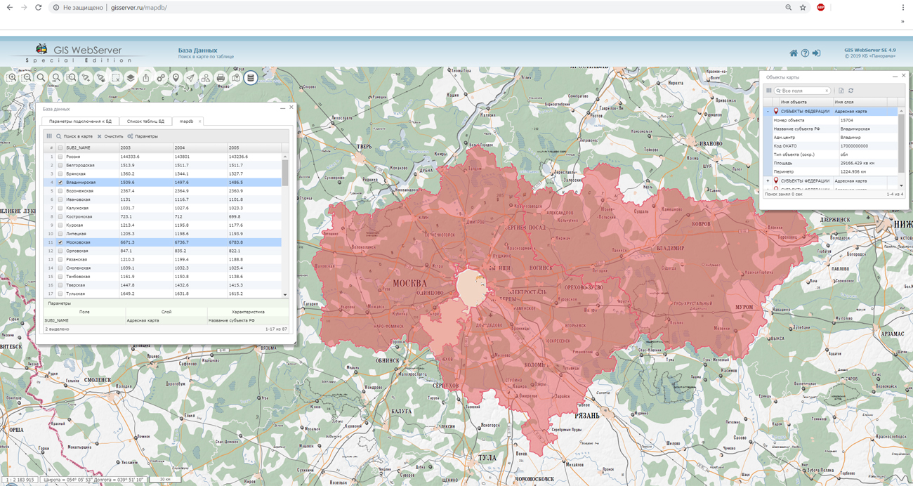
In KB "Panorama" the version 4.9 is developed. In the new version of the program the "Database" component is added which allows you to combine information about the terrain object from the database with the geodata of map's service the . The component carries out search for objects of a map according to the table data and the table filtration when selecting map objects. The logical link with the map object is established by storing the value of the characteristics of the map object in the database table record. For work it is possible to use various DBMSs: PostgreSQL, MySQL, Microsoft SQL Server or MS Access. You can familiarize yourself with the example of work of the "Database" component on the site. The new tool "Unloading of layers" provides the ability to download and to save map data files in formats GML/XML, GeoJSON, SXF or TXF. Downloading of files is carried out in the Web-browser. When opening local layers from files of GeoJSON format, support was added for the geometry of objects in the EPSG 3857 coordinate system. The "Matrix value in point" component and the application administration module have been updated.
The toolkit of developing the Web-applications the has been improved, which expands possibilities of GIS WebServer SE and can be integrated into other information systems. Access to data (images, vector maps and terrain information) is provided by web-services using common OGC protocols and ISO standards. Service of GIS WebService SE (OGC WMS/WMTS) provides spatial information in the form of graphic images. Various types of high-altitude data are used as a digital elevation model: matrixes (in the formats SRTM, GeoTIFF, IMG, MTW), TIN-models, point cloud and others. At request the most accurate data onto a specified terrain site with a given resolution is automatically sampled. To transfer data of the digital terrain model to the Web, the WCS protocol is used. The relief data is represented as tiles and cached on the client.
As a source of spatial data, the can be. It provides the collection, storage, search and delivery of spatial data in exchange formats, a displaying the state of the data bank in the form of maps-schemes, the automated formation and updating of geo-covers.
GIS WebServer SE is used in the construction of closed corporate systems to ensure the protection of data having a security classification or a trade secret. GIS WebServer SE is certified for Level 2 of absence of undeclared capabilities. The new version of the program expands the application's capabilities in solving problems of analysis, management and long-term planning of the territories development. GIS WebServer SE is implemented using the toolkit of GIS WebToolKit SE, which can be used in development tools that use the JavaScript.
The new version of the program is available on the website in the section.


On October 11, 2019, the specialists of KB Panorama based on the new laboratory the "Researching the issues of creating a unified geographic information space" of the presented the company's achievements in the field of spatial data processing. At the meeting, the possibilities of were considered for collecting and processing terrain data with the aim of creating digital topographic and special maps, elevation matrices, orthophotomaps, terrain models, astronomical, geodetic, gravimetric and other data for the formation of a single geographic information space of the Russian Armed Forces. The participants of the meeting were shown software solutions: , , , , . All software, survey tile maps of Russia, city plans of the Russian Federation were provided to the new laboratory for constant use in scientific work.
Technopole ERA was created to ensure the search, development and implementation of breakthrough technologies in the defense sector. Close attention was paid to educational programs for young scientists in the ranks of the Russian Army. The location of the technopole in the city of Anapa creates comfortable conditions for work and life.


In KB "Panorama" the version 12.7.4 is developed. In the new version of the program, the register of premises and objects of a single immovable complex is implemented. A single immovable complex is a combination of buildings, structures, and other things united by a single purpose, inextricably linked physically or technologically, including linear objects (railways, power lines, pipelines), or located on one land plot.
The register of objects of a single immovable complex provides storage of the accounting and technical characteristics of the complex and all cadastral objects included into its composition. Due to the spatial and logical connections, there is ensured an integration with the registers of land, buildings and structures. The composition of the stored data includes various cadastral documentation, schemes, plans, drawings, images, accounting and technical characteristics and information about the copyright holders. The location of a single immovable complex on the map is provided.
Within the framework of maintaining registers of urban development objects, the “Premises” mode has been developed. It makes it possible to take into account information about real estate located inside a building, structure or other real estate object. The storage of information on residential and non-residential premises, apartments, rooms and parking spaces is provided. There is the possibility of flexible grouping of premises, taking into account the classification by cadastral belonging, and by other characteristics, for example, production and administrative premises. The premises accounting is directly related to the building or structure in which it is located and contains various attributes, a list of which may be customized by the user. When viewing information in the register of real estate objects, the "Premises" element is added, containing a list of all apartments, rooms, parking spaces and other premises located within the real estate.
The updated mode "Application of a document for real estate objects" allows you to use one document for several land plots, real estate and premises. The “What the subject owns” mode is supplemented with information about the property of the copyright holder, which includes data on land plots, real estate and premises. A new protected resource has been added when delimiting user access rights for creating and deleting the real estate registers.


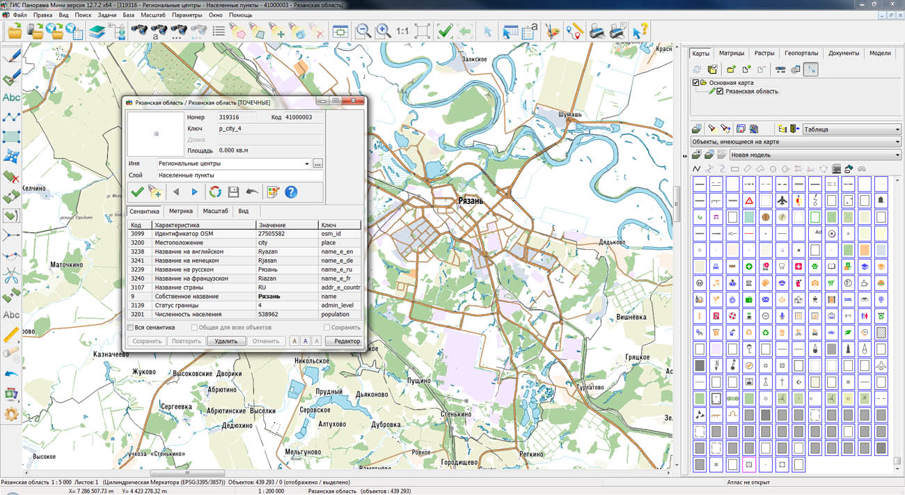
On the geoportal , the maps of regions of the Central federal district, which were formed according to OpenStreetMap data, were updated. The composition of the maps includes Lipetsk, Oryol, Ryazan, Smolensk, Tambov, Tver, Tula and other areas. The source data was obtained from the website. For work with the maps it is possible to use the program of GIS Panorama Mini or other software products of KB "Panorama".
The maps were led to the modernised classifier of large-scale plans of scale 1: 5 000 (map5000m.rsc). Publishing of updates in bank of spatial data is made by using the program of . Publishing contents of bank of spatial data on the geoportal and data access for downloading are implemented by means of .
Free maps on the basis of OpenStreetMap data are available for download on the page "Digital maps and images".


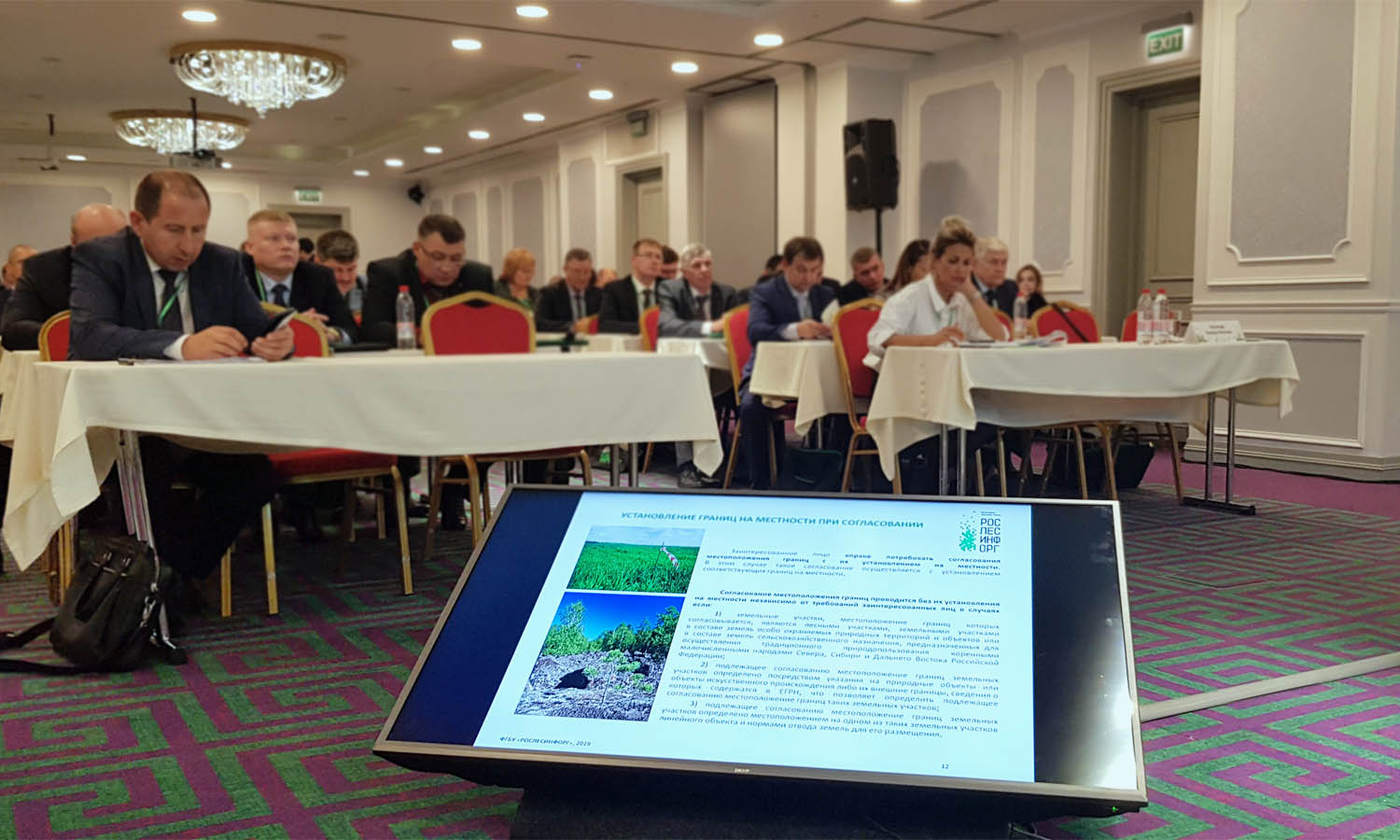
Representatives of KB "Panorama" took part in the scientific-practical conference . The event was held in Kazan from October 9 to 12, 2019, the event was organized by the Federal Forestry Agency with the support of the President of the Republic of Tatarstan.
Within the limits of the seminar "Topical issues of cadastral activities. Ensuring the establishment of borders of forest districts" the report and presentation" Technology of an establishment of borders of forest districts and forest parks" have been presented. During the presentation, software technology was considered for designing and establishing the borders of forestries and forest parks, implemented in the . The technology was developed with the close cooperation of specialists of KB "Panorama" and "Roslesinforg". It is created in accordance with the provisions of existing regulatory legal acts. In addition, the meeting's participants were genuinely interested in the capabilities of the server software the , which can be used for maintaining a fund of materials from the state forest registry.
In the software products of KB "Panorama" (GIS "Panorama", and others), new modes are added that are used in the designing the forest areas, forest parks, the establishment of their borders, the division of forestries, forest parks into local forestries, determining the quarter network. Forest quarter - a part of the forest, delimited by cuttings or natural boundaries (for example, rivers). Each quarter has a permanent number. By current standards, the numbering of blocks in a forest goes from west to east, in rows, from north to south. The mode "Numbering of objects, in rows" provides the formation of an object’s registration number in accordance with its location on the map and is intended to fill numbers of forest blocks in rows. To automate the process of merging the forest quarters into district forestries, the mode "Union of objects" is intended. The mode provides stream processing of map objects that have adjacent borders and the same attribute values. The program collects statistics on semantics, selects unique values, automatically creates samples of objects with the same values of semantics and performs their merge. The result of the execution is a multipolygon, including merged and isolated contours for each unique combination of semantic values, for example, the name of forestry and the number of the area.
The conference became one of the largest specialized platforms for forest accounting. The event allowed representatives of ministries, business and experts to discuss topical issues of forest exploitation and forest management. Participants of the meeting were more than 300 specialists from 40 subjects of the Russian Federation.


Ph.: +7 (495) 739-0245, +7 (925) 221-1603
www.gisinfo.ru | panorama@gisinfo.ru
105005, Russia, Moscow, Baumanskaya Street 7, building 1, office 229 (m. Baumanskaya)
Copyright © Panorama Group 1991 - 2024


 Mobile version
 Full version