Copyright © Panorama Group 1991 - 2024

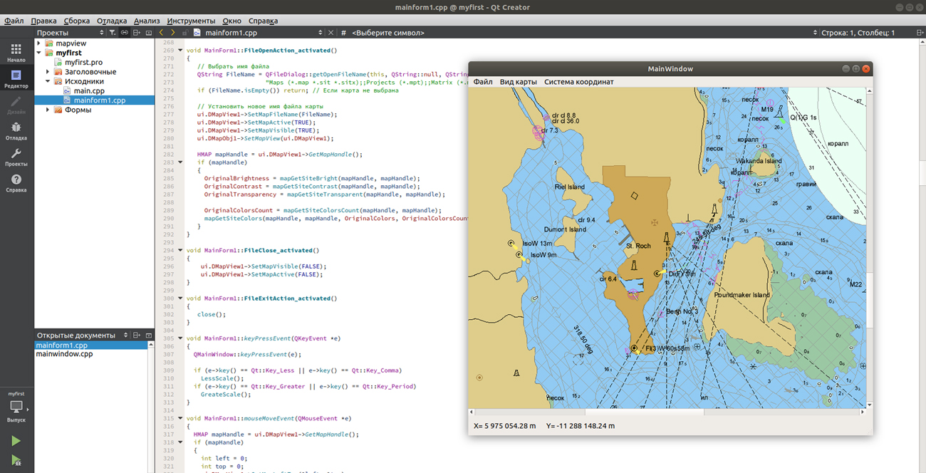
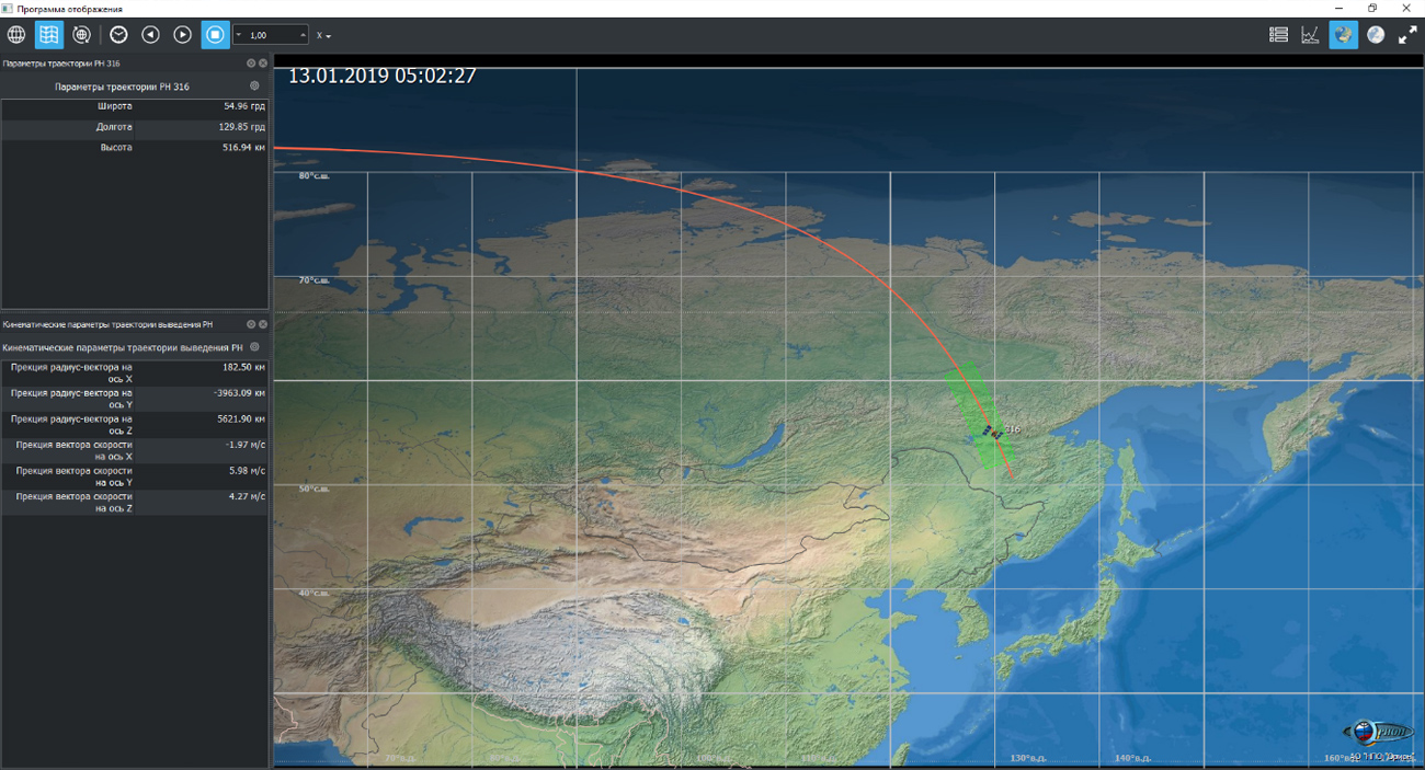
Specialists of JSC "Orion" on base of the GIS Constructor and components of free software Marble have developed a special modular graphic application. This software package, which includes the tools of , allows you to connect a digital thematic map of the World and visualize the motion of a spacecraft against the background of a map of the earth's surface or as a three-dimensional model of the Earth. The graphic application of JSC "SPA “Orion" is a part of the project for the creation of a ground-based special complex for the operation of the space geodetic system GEO-IK-2.
GIS Constructor is a set of geoinformation components for use in the visual programming environment of Qt Designer, which allows you to develop your own GIS applications. The visualization of the contents of digital maps is made in conventional symbols adopted for topographic, geographical and various special maps. Geoinformation system has ample opportunities for performing calculations, for providing display of spatial data on various graphic devices in standard and user systems of conventional symbols. The main functions can be executed in multithreaded mode. It supports automatic optimization of used memory for processing large amounts of data (tens of gigabytes) on limited resources (hundreds of megabytes).
The toolkit is adapted to work on a wide range of platforms and supports operating systems such as Astra Linux SE, MSVS, CRTOS "Neutrino", "Elbrus", "Zarya", Ubuntu, Alt Linux, QNX, CentOS and others. It can be used in computer complexes with processors of architectures ARMv7, Elbrus, PowerPC, Intel x86, Intel x64 and others.


In KB "Panorama" the "Workstation of Agronomist" version 12.7.2 is developed. In the new version in the "Satellite monitoring" task, the possibilities are added for receiving and viewing maps of heterogeneity of soil of agricultural plots and maps of need for nitrogen. Heterogeneity maps consist of a set of objects representing a given number of zones with the same level of crop development and other similar characteristics based on calculations of the NDVI vegetation index. Mapping is performed by several automatically selected images with different weather conditions or by a specific image on the desired date. Maps of need for nitrogen reflect need for fertilizer by chosen NDVI image and on the basis of the entered, planned, minimum and maximum dose.
The use of soil heterogeneity maps and nitrogen requirements in differential fertilization systems will reduce costs and increase yields due to an adaptive approach to the processing of zones within the working areas. For providing remote multi-user authorized access, maps are recorded into the database and on the . The source of data is the external service of Geosys company.
All modes of the "Satellite monitoring" task have been updated to the latest faster and more stable API version of Geosys company. This made it possible to add support for sub-objects in work areas, it became possible to receive and view average daily values of the EVI vegetation index. When viewing vegetation index matrixes, additional information about weather conditions at the time of shooting was added.


In KB "Panorama" the version 12.7.1 is developed for the x64 platform. In the new version of the program in the "Navigator 3D" task, there is improved the mode of loading models from the formats of Collada, TLS, OC3 into the DB3D database of three-dimensional tiles. For all formats of the original models, editing the coordinates of the model binding point is supported, not only in height, but also in latitude/longitude. When loading several different models into one database file, the specification of the general overall dimensions of all models in the database metadata has been added. Ability is added to select the size of the tile for the loaded model. In the case of an attempt to load models with different tile sizes into the database, a warning is issued, and the user can select another database file with the appropriate parameters.
Sorting the maps of SITX format with encryption of stored data by the user password is accelerated.
For finding the causes of repeated errors in the program's work the "Diagnostic log" is added. If some action with the program causes an error, then for its diagnosing, it is desirable to enable the "Diagnostics log" and to repeat the action causing an error. "Diagnostic log" is created in the folder \ProgramData (or \Users\All Users), which is usually located on the C: drive. The name of the log can be set in the menu \Options\Location data. Enabling the diagnostic log may be done in the menu \Options\Diagnostics log. The generated log file describing the error can be sent to the technical support of KB "Panorama".


In KB "Panorama" the version 8.6 is developed. The new version adds support for loading pyramids of tiles of format BIR (mbtiles) stored in a SQLite database into the Databank. Pyramids of tiles can be placed and downloaded as separate folders or from a common directory. GIS Server automatically determines the composition of the pyramid subdirectories by metadata stored in the SQLite database. Processing of pyramids of three types is supported: remote sensing data, matrixes of elevation, images obtained from digital maps. Pyramids of tiles recorded into virtual folders of the GIS Server are automatically published for clients who have access rights to these folders.
Processing of command is added for performing the control of absence of the information forbidden for displaying on Public Digital Topographic Maps (PDTM) under the scheme of control which is customized in the Complex of control of absence of the closed information on the PDTM. By the command of an external application (by Data Bank operator), the GIS Server can monitor the list of SXF files placed in a virtual folder or stored in the Data Bank. The control protocol is generated in the form of an html file by a report template. The installation includes a checkopen.cxml scheme, prepared according to the classifier 25t05gopen.rsc. The scheme can be applied to the DTM of various scales corresponding to the information cartographical support.
GIS-core libraries are updated. The transformation of the coordinate system of raster and matrix data during the formation of a geo-cover is accelerated by 10-15 times due to the use of multi-thread processing for multi-core processors and new algorithms for tile processing.
The new version of the program is available for download on the page.


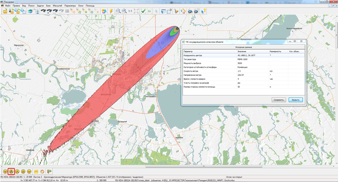
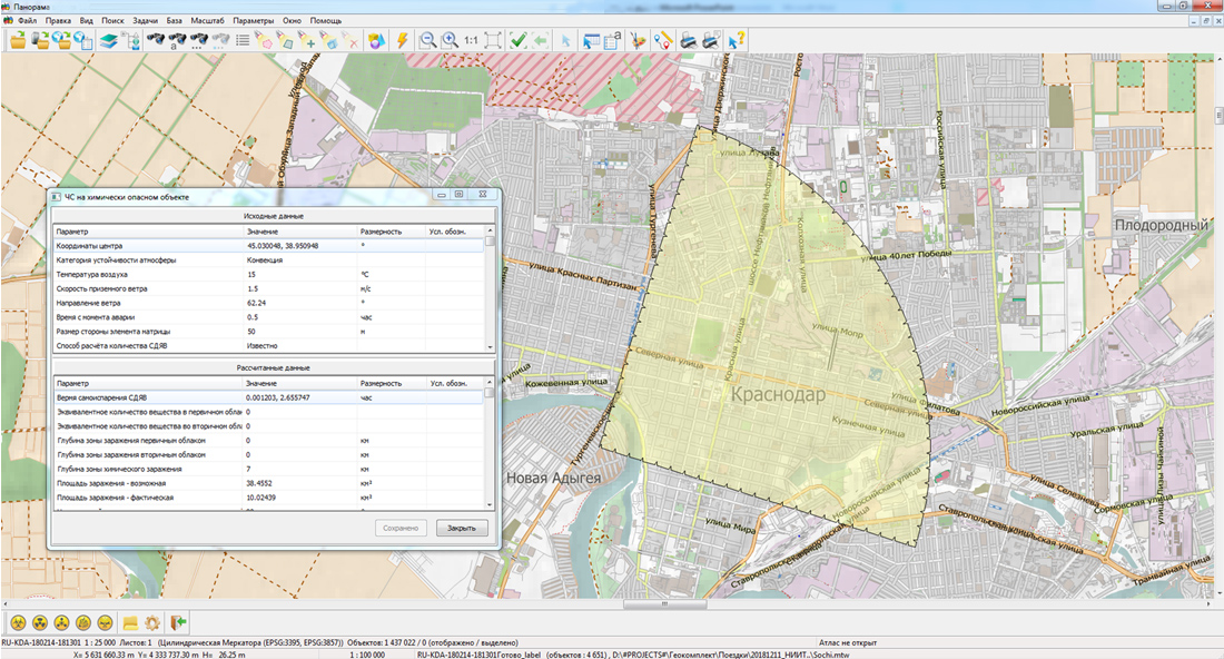
The new technology allows you to use a single mathematical apparatus that allows you to simulate the consequences of emergency situations of natural and man-made nature. It is implemented for desktop and web-based applications in Windows and Linux operating systems.
With the use of this technology, KB "Panorama" has developed a new version of the complex for predicting the consequences of emergency situations. The complex is an applied task, working as a part of 12 and . Models of emergency situations (ES) are implemented according to the following scenarios:
- occurrence of an emergency at a chemically hazardous object;
- occurrence of an emergency at a radiation-hazardous object;
- occurrence of an emergency at a biologically hazardous object;
- occurrence of emergency situations at an explosive object;
- occurrence of emergency situations at a hydraulic structure.
The complex allows you to build a zone of possible damage in the established conventional symbols and to perform the calculation of the parameters of the damaging factors on the situation map of the area of emergency. The resulting map is intended to further perform various analytical operations: determining buildings (personnel, population) that have fallen into the affected area, calculating the distance of objects from the accident zone, building evacuation routes or entering special equipment using the road graph, etc. The complex was developed on the basis of the guidelines adopted in the Russian Federation.
The new presentation "Forecasting of natural and man-made emergencies using the technologies of KB "Panorama"" is available in the Download-Presentations section.

Ph.: +7 (495) 739-0245, +7 (925) 221-1603
www.gisinfo.ru | panorama@gisinfo.ru
105005, Russia, Moscow, Baumanskaya Street 7, building 1, office 229 (m. Baumanskaya)
Copyright © Panorama Group 1991 - 2024


 Mobile version
 Full version