Copyright © Panorama Group 1991 - 2024

Specialists of KB "Panorama" for English-speaking users prepared a series of video lessons for working with . The training course of twelve lessons will tell you about the system tools for creating and editing maps, checking the quality of vector maps, performing calculations and building 3D models. To date, three video lessons are prepared and published.
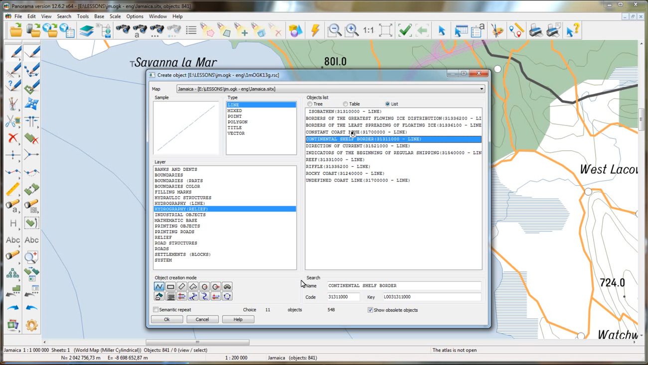
From the first lesson, , you will learn how to create and edit objects on a map. It will examine various ways to create new objects and fill in their characteristics.
In the second lesson, , modes are shown that allow you to edit the turning points of map objects. Also you learn about some functions for changing the topology of objects.
The third lesson is devoted to the creation and editing of a classification system of spatial objects and their attributes. The lesson shows you how to create layers of the classifier, objects of different types of localization and demonstrates the key possibilities for creating conventional symbols for map objects.
You can get acquainted with the training materials in English in the section .


In KB "Panorama" the version 4.3.2 is developed. In the new version the possibility of creating maps by database tables is added. The "Geocoding" component connects to the database, reads the coordinates of objects and creates point objects on the map. The result can be saved on the user's computer in GeoJSON format. In addition, geocoding parameters can be saved for future use. The "Geocoding" component is implemented as a plug-in, whose code can be used as an example for developing your own components.
In 3D map the possibility to select a route of motion in the "Free flying" mode is added. The route of movement can be pre-prepared or downloaded from a file from the user's computer.
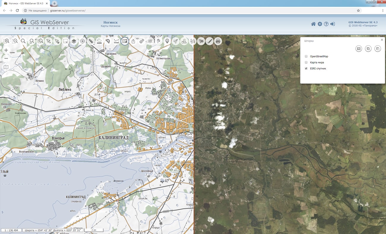
The toolkit of developing the Web-applications the GIS WebToolKit SE has been improved, which expands possibilities of GIS WebServer SE and can be integrated into other information systems. Access to data (images, vector maps and terrain information) is provided by Web services using common OGC protocols and ISO standards. Service of GIS WebService SE (OGC WMS/WMTS) provides spatial information in the form of graphic images. Various types of high-altitude data are used as a digital elevation model: matrixes (in the formats SRTM, GeoTIFF, IMG, MTW), TIN-models, point cloud and others. At request the most accurate data onto a specified terrain site with a given resolution is automatically sampled. To transfer data of the digital terrain model to the Web, the WCS protocol is used. The relief data is represented as tiles and cached on the client.
As a source of spatial data, the can be. It provides the collection, storage, search and delivery of spatial data in exchange formats, a displaying the state of the data bank in the form of maps-schemes, the automated formation and updating of geo-covers.
GIS WebServer SE is used in the construction of closed corporate systems to ensure the protection of data having a security classification or a trade secret. GIS WebServer SE is certified for Level 2 of absence of undeclared capabilities. The new version of the program expands the application's capabilities in solving problems of analysis, management and long-term planning of the territories development. GIS WebServer SE is implemented using the toolkit of GIS WebToolKit SE, which can be used in development tools that use the JavaScript.
The new version of the program is available on the website in the section.


In the journal article "Analysis and preparation of remote sensing data from open sources for systems of exact farming" is published. The article considers the possibility of using open sources of the Earth's remote sensing data for satellite monitoring of agricultural land and supporting systems of exact farming. The article lists the sources of current data with open access and suitable for use in exact farming systems, describes the features of internal files formats and ways of converting the information into an agricultural GIS. For each source, the levels of processing the provided data and methods necessary for reduction of data to a single high level are considered in detail.
The presented technologies of satellite monitoring are implemented in software products of KB "Panorama": , , "Workstation of agronomist". Integration of software solutions of KB "Panorama" with external services ("Public Cadastral Map", "Atlas of Agricultural Lands", "VEGA" and others) provides the possibility of obtaining geolocated remote sensing data including in the form of thematic information. Using the services of the company Geosys allows you to get geolocated values of vegetation indices, to build zoning maps and the differentiated application of fertilizers.
The corresponding modes allow you to download the matrix of qualities with the values of the indices NDVI, CVI, EVI, GNDVI and average daily values along the contour of the field over the last 10 years. Zoning maps, built on the historical values of NDVI, make it possible to identify problem areas in the working areas and with high accuracy to predict crop yields, and also to make the decision on necessity for fertilizer application.
You can familiarize yourself with the materials on the use of remote sensing data from open sources in exact farming systems in the Articles section.


In KB "Panorama" the version 12.1.7 is developed. The new version of the service has added options for loading all published data into RAM if it is sufficient on the server. In this case, the program allows you to simultaneously perform a large number of requests and distribute the load between the system cores. Previously loaded data that is no longer in use is unloaded from the service and deallocates space in RAM.
The program improves the reliability of the resources deallocating when working with large amounts of spatial data. When critical errors occur or when the service is restarted, the vector, raster and matrix data will close correctly in any situation. It allows to avoid data loss or data corruption.
GIS WebService SE supports all international standards (OGC WFS, WFS-T, WMS, WMTS, WCS), with the help of which the transmission and display of spatial data is carried out. The program has the ability to issue tiles by any user or local coordinate system. The application is implemented on Windows and Linux platforms, is compatible with Apache, IIS and nginx web servers.
A new version of the program and documentation are available on the website in the section.


KB "Panorama" prepared a digital geographical map of scale 1: 1 000 000 in format SXF onto the territory of the Republic of Madagascar. obtained according to information from the website has served as source for map's preparation.
The map contains information about the quantity of inhabitants for cities and the names of settlements in Russian. As additional materials the World map of scale 1: 5 000 000 and data of were used. The map is led to the classifier of geographical maps of scale 1: 1 000 000 (1mogk13g.rsc). It can be used for the general estimation of the terrain and studying of an environment, an ensuring of educational process, as a basis for creation of geographical maps of smaller scale, thematic and special maps and solving other tasks.
The map is distributed free according to the free . Digital geographical map of scale 1: 1 000 000 in format SXF is available for downloading on page the "Digital maps and images".


Ph.: +7 (495) 739-0245, +7 (925) 221-1603
www.gisinfo.ru | panorama@gisinfo.ru
105005, Russia, Moscow, Baumanskaya Street 7, building 1, office 229 (m. Baumanskaya)
Copyright © Panorama Group 1991 - 2024


 Mobile version
 Full version