Copyright © Panorama Group 1991 - 2024

In KB "Panorama" the version 5.5 has been developed for operating systems Astra Linux, Windows, CentOS. In "the Editor of a map" the possibility has been added to customize the graphical view of objects of server layers. Users can define parameters of type of lines and areas: color, transparency, thickness and type of line, choose shadings, fonts and their design for the text. The description of the customized view of the object is saved as an SLD style in accordance with the standards OGC 05-078r4 v.1.1.0 and OGC 02-070 v.1.0.0 - SLD (Styled Layer Descriptor). Use of SLD styles when editing allows you to create objects on the map whose view does not depend on the classifier of the map. Possibilities of measurements in 3D map were expanded, distance calculation between points according to the relief of the 3D model has been added. The total path length, length and azimuth of each of its individual sections are calculated. Waypoints are displayed on the map and can be moved or deleted by the user. When the path changes, the calculation of measurements is automatically updated. Searches in the map can now be performed only for visible objects. When selecting objects according to the search criterion, the filter for displaying objects set according to the legend of the layer is additionally taken into account. The customized filters of displaying objects are saved between sessions of the user.
In the new version, the Web application development toolkit is enhanced, which extends the capabilities of GIS WebServer SE and can be integrated into other information systems. Access to data (images, vector maps, and terrain information) is provided by Web services using generally accepted OGC protocols and ISO standards. The service (OGC WMS / WMTS) provides spatial information in the form of graphic images. As a digital elevation model, various types of elevation data are used: matrixes (in SRTM, GeoTIFF, IMG, MTW formats), TIN-models, point cloud and others. The service provides the ability to publish three-dimensional terrain models unloaded in DB3D format. These models can be obtained from files of the COLLADA type, as well as from photorealistic three-dimensional models of unlimited size (TLS, OC3).
As a source of spatial data, the can be used. It provides the collection, storage, search and delivery of spatial data in exchange formats, displaying the state of the data bank in the form of maps-schemes, and the automated formation and updating of geo-covers.
GIS WebServer SE is used in the construction of closed corporate systems to ensure the protection of data having a security classification or a trade secret. GIS WebServer SE is certified for Level 2 of absence of undeclared capabilities. The new version of the program expands the application's capabilities in solving problems of analysis, management and long-term planning of the territories development. GIS WebServer SE is implemented using the toolkit of GIS WebToolKit SE, which can be used in development tools that use the JavaScript.
The new version of the program and the documentation are available on the website in the section.


On the geoportal , the map of the Republic of Armenia, formed according to OpenStreetMap data, was updated. The source data was obtained from the website. For work with the map it is possible to use the program of GIS Panorama Mini or other software products of KB "Panorama".
The map was led to the modernised classifier of large-scale plans of scale 1: 5 000 (map5000m.rsc). Publishing of updates in bank of spatial data is made by using the program of . Publishing contents of bank of spatial data on the geoportal and data access for downloading are implemented by means of .
Free maps on the basis of OpenStreetMap data are available for download on the page "Digital maps and images".


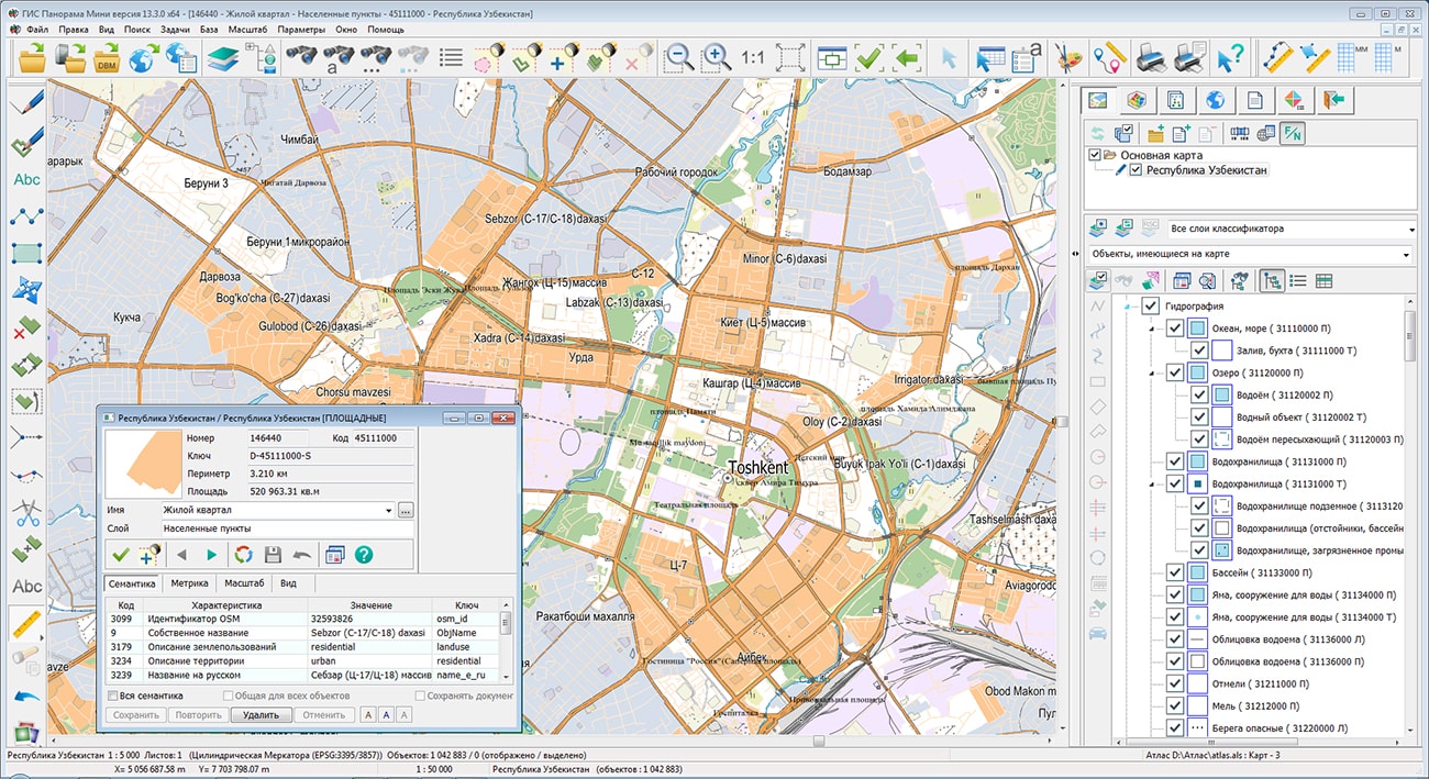
In KB "Panorama" the version 13.3.0 for the x64 platform is developed . The new version of the program adds the ability of direct connection to large spatial databases containing millions of records for display and editing in the form of vector maps in cartographic conventional symbols. Direct editing of database records with fields of various types containing the coordinates of objects is provided. Fields of spatial description of objects for DBMS PostgreSQL with expansion PostGIS, DBMS Oracle with expansions Oracle Spatial and ArcSDE are supported. Fields of spatial description of objects for PostgreSQL DBMS with PostGIS extension, Oracle DBMS with Oracle Spatial and ArcSDE extensions are supported.
The program allows to edit simultaneously contents of the databases connected directly and through the , to carry out an information exchange between various databases, to agree coordinates and attributes of objects in different databases, jointly to display in the form of graphic layers the information from different databases, to combine the data with images, matrixes of heights, vector maps and the data from various geoportals and web-services.
Tools of connecting to databases in the GIS duplicate the capabilities of the GIS Server and the Spatial DB Service, but can be used in individual work. It is advisable to perform collective access to display and edit databases in the form of vector maps through the GIS Server.
Support for the RSCZ format - an RSC classifier file packed into a zip archive has been implemented. The volume of the stored file is reduced on average by 4-5 times without loss of data opening speed. RSC classifiers can be replaced at any time with packed files with the rscz extension. At opening a vector map, the GIS checks the presence of classifiers with extension rsc and rscz. The packed classifiers open only for reading.
At maps sorting with compression into MAPZ\SITZ format, the RCS classifier is compressed and recorded together with a map. Into one file MAPZ the works region from several thousand sheets with the classifier can be written down, that simplifies an exchange and application of vector maps.
In the "Classifier Editor" for the dialogs "Search of objects" and "Filter of objects" the ability was added to use a filter by layers, types, keys, codes and other characteristics of objects. The bookmark "Properties" has been added, which allows you to select objects that use in conventional symbols the certain colors, having specified semantic characteristics, which are assigned a 3D view and by other properties.
In the "Map Editor" the possibility has been added to enter point signs from the keyboard by the list together with semantics of objects. For this purpose in the "Create object" dialog, the method of creating the object is selected - "Creation from the keyboard". In the table for entering coordinates, you can enter the coordinates of any number of point objects. When the "Show object semantics" property is enabled, columns with the names of possible object semantics will appear next to the columns of coordinates points. After filling the table and clicking the "Save to Map" button, the point signs will be put together with their semantics.
The interface of the Map Legend task (F11) has been updated, changing the contents of displayed objects for all maps with one classifier is provided when the property "Set a model for maps with a common classifier" is enabled. Autoupdating the state of the objects tree has been added when changing the composition of displayed objects from other dialogs and tasks.
The list of parameters in the command line for starting the GIS has been expanded. The following options are supported: /e - open the Map Editor, /n - open the 3D Navigator, /h - do not open the maps that remained open in the last session, /d - open the diagnostic protocol, /1 - do not start the second GIS instance, /a - open the map atlas, /u - register the client on the GIS Server.
The restriction on degree of increase in the image of rasters and matrixes is excluded. Rasters and matrixes which were drawn up to scale 1:10, are drawn now without restriction of increase of the picture.
The new version of the program is available for download in the section.


In the period from May 25 to May 27, 2020, the was held online, dedicated to the 241st anniversary of the founding of Moscow State University of Geodesy and Cartography ().
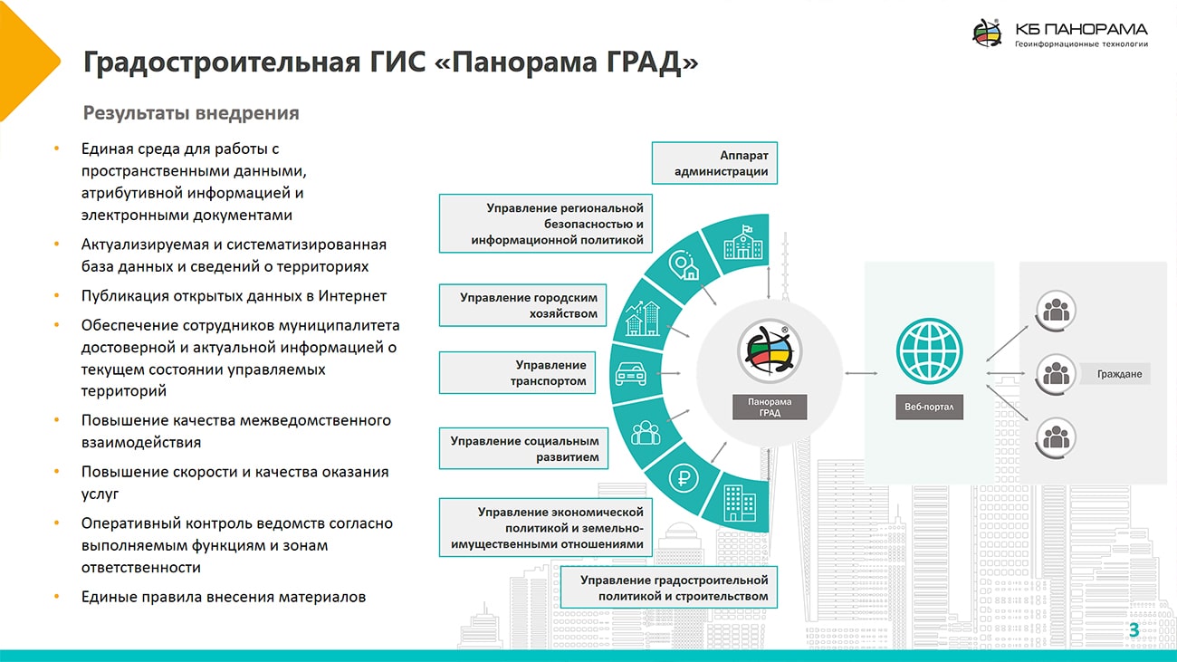
At the conference, KB Panorama was presented by the project manager Alexander Kirichenko with a report on the topic "Urban-planning geoinformation system "Panorama GRAD". The report highlighted the current problem of the impossibility of efficient development of territories and the formation of a comfortable living environment without the introduction of an urban planning system. "Panorama GRAD" software combines the technologies of systematic data storage, automated preparation of documentation, maintaining ISOGD and analytical tools to support the adoption of managerial decisions by authorities and municipal authorities.
The implementation of the urban planning system allows creating a unified environment for working with spatial data and documentation, increases the level of interagency cooperation, and also improves the speed and quality of public electronic services. Heads of organizations get quick access to always up-to-date information on urban-planning activity, as well as additional means of monitoring the work of departments.
In total, the conference held 8 thematic sections in priority research areas, in which leading Russian and foreign scientists, experts, representatives of relevant ministries and departments, as well as representatives of the business community took part.


In KB "Panorama" the presentation has been prepared. Today, spatial data are used in any field of activity: communication and education, urban planning and nature management, mining operations and transportation. is a geographic information system whose users can remotely view, edit and analyze spatial data using Web browsers. The system has an open code and provides the ability to configure and use geoportals for various purposes, where on the maps you can display the territorial divisions of the company, accounting facilities, location of operating facilities, traffic routes and other information.
GIS WebServer SE performs data exchange with the server software products of KB "Panorama" and external geosystems through a software interface. The map image is formed from various sources and according to various exchange protocols and has a multilayer structure. Users of system can publish their own layers of data, customize their display and use the customized GIS-toolkit for operations on an interactive map.
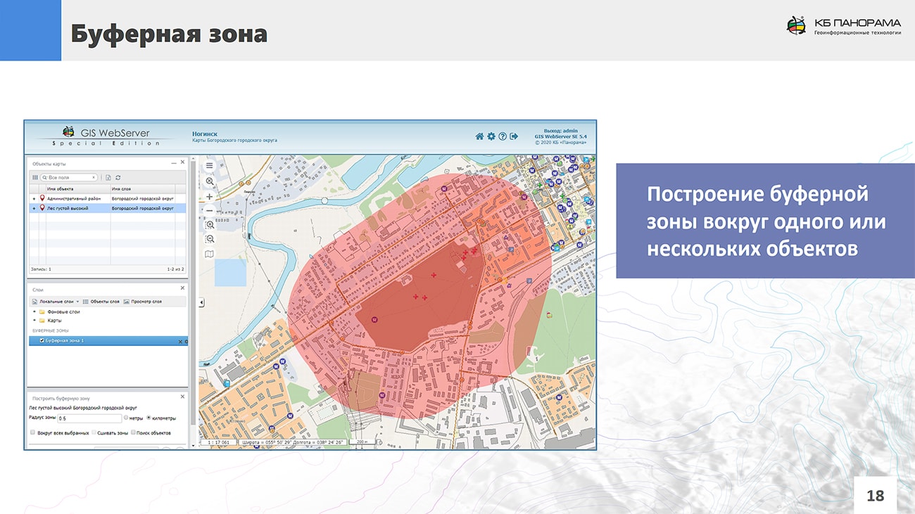
GIS WebServer SE works together with cartographical service the , applying its wide opportunities for publishing, using and storing data. The application has interfaces for users and for system administrators. The interface of the user contains controls by an interactive map and a variety of tools for working with spatial data.
The following features are available to users: controlling a map, scaling, image movement, managing the content of visible map layers and visible objects of a layer, management of a sequence and a transparency of layers; obtaining the attributive information about map objects, various types of searching for objects in the map; remote editing of attributes and geometry of objects, creation, removal of map objects (if authorized); 3D map visualisation, display of complex and realistic 3D terrain models, execution of calculations on a map; registration of the main actions of users and administrators when working with the system in a log. The automatic authentication of users of the appendix authorised by means of safety of an operating system or means of the Web-server is provided.
The interface of GIS WebServer SЕ administrators implements the functions of customization and management of system: management of groups and users of system; customizing privileges of users groups for using data and allowed actions in the system; map project management: setting up data contents and tools for data processing and analysis; logging work.
are available on the KB Panorama demonstration portal. Training and presentation materials are available for download on the page.


Ph.: +7 (495) 739-0245, +7 (925) 221-1603
www.gisinfo.ru | panorama@gisinfo.ru
105005, Russia, Moscow, Baumanskaya Street 7, building 1, office 229 (m. Baumanskaya)
Copyright © Panorama Group 1991 - 2024


 Mobile version
 Full version