Copyright © Panorama Group 1991 - 2024

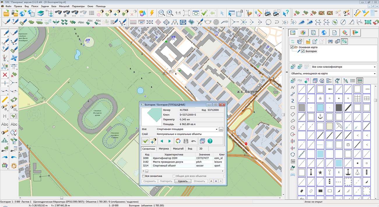
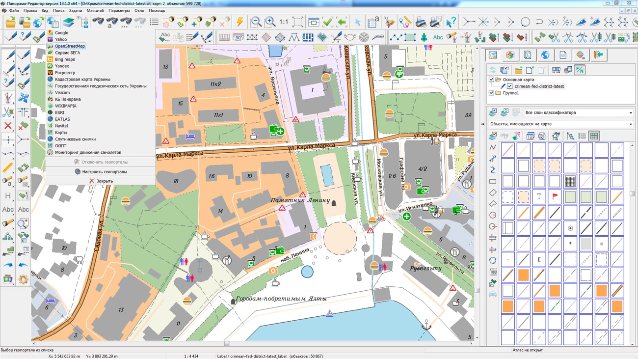
The geoportal was supplemented with a map of the Federal Republic of Nigeria, formed according to OpenStreetMap data. The source data was obtained from the website. For work with a map it is possible to use the program or other software products of KB "Panorama".
The map was led to the modernised classifier of large-scale plans of scale 1: 5 000 (map5000m.rsc). Publishing of updates in bank of spatial data is made by using the program of . Publishing contents of bank of spatial data on the geoportal and data access for downloading are implemented by means of .
Free maps on the basis of OpenStreetMap data are available for download on the page "Digital maps and images".


In KB "Panorama" the is developed. The new version of the program has improved tools for monitoring the quality of digital information about the area, for forming a spatial database and metadata, for searching for data, performing calculations and generating reports. The formation of a distributed data warehouse and differentiation of access to spatial information is provided by the program. The technology for constructing a spatial data infrastructure based on complies with international standards ISO 19100, normative documents of the INSPIRE European Initiative, GOSTs of the Russian Federation and is based on the company's own developments that meet the world's advanced requirements for creating distributed storage and providing wide access to spatial data of federal, regional and municipal levels.
In the "Preparing for printing" section of the list of applications, the "Report Designer" application has been added for quick creation of graphic documents using maps insets and image insets.
The wizard for creating a new project allows by "one-click" to form a template of graphic document with ready-made layout and footers (headers, corner stamps and other elements).
Modes for drawing maps insets and images inserts, editing content, positioning and scaling images inside the insets make it easy to create visual and informative graphic documents.
The creation of new and an editing of existing templates is supported for their further replication when creating new graphic documents.
The dimensions of the printed fields of created document are automatically transferred to the print dialog, which allows you to quickly print a document without selecting a printable area and setting indents.
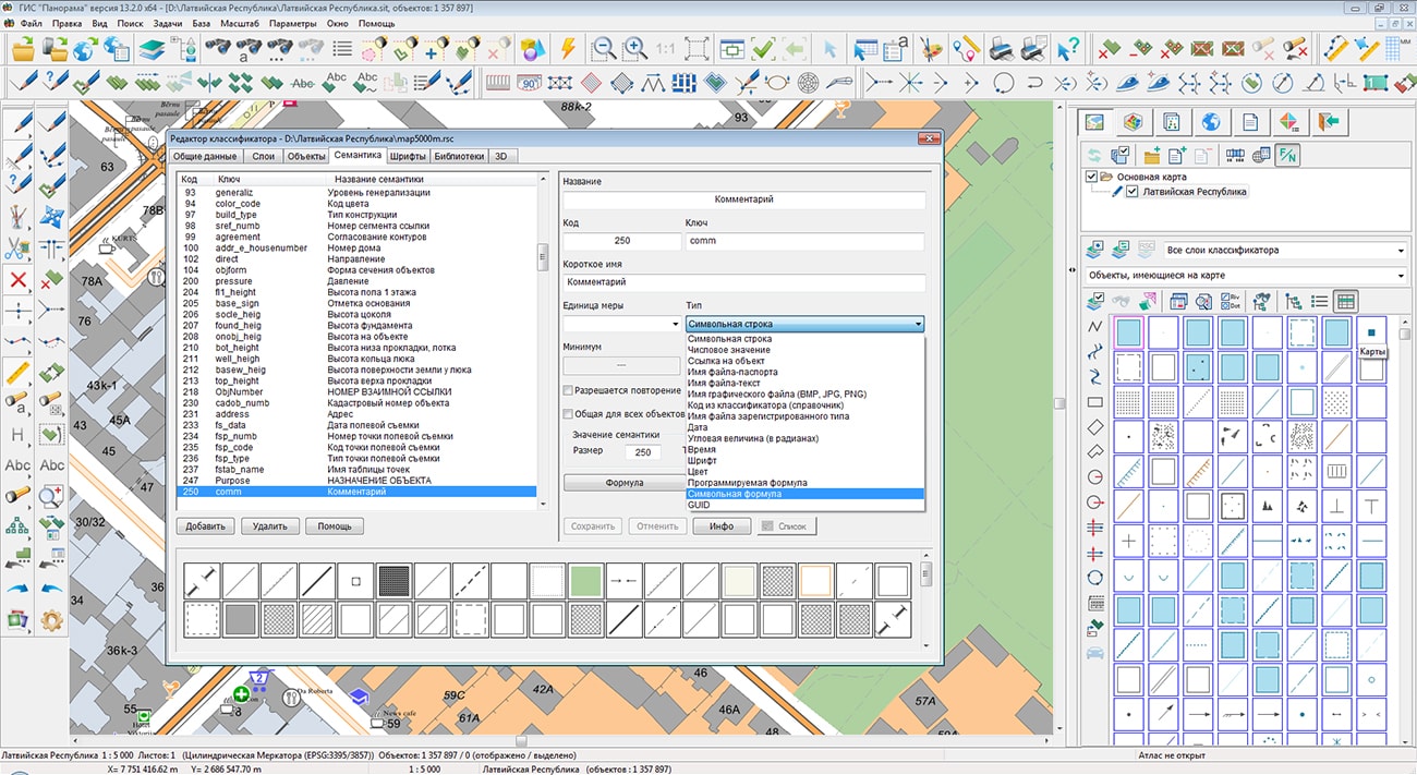
New types of objects semantics are added: semantics the numerical formula and semantics the symbolical formula. New types complement the programmable semantics the formula, the value of which is calculated in the connected iml-libraries. For new types of computed semantics, mathematical or logical expressions are defined that are executed without programming. For the numerical formula in semantics description the mathematical expression (formula) is indicated that contains numbers, mathematical operations, links to the values of semantics of object, its area, perimetre, coordinates of the first point in meters or degrees, coordinates of the geometrical center of object and other properties. For example, the following operations can be used as mathematical operations: +, -, *, /, max, min, arm, sin, cos, tg, ctg, abs, sqrt2, sqrt3, pow2, pow3.
To insert the semantics value into the formula, the symbol # is indicated behind which there is a code of semantics and in brackets a value by default is contained. For example, # 1 (10) - take the value of semantics 1, if the object does not have semantics with code 1, take the value 10. For an approximate estimate of the timber stock in the forest, one can use the expression: S/(#61(1)*#61(1))*PI*#60(0.5)*#60(0.5)/4*#1(4). Divide the forest's area S by the area occupied by one tree - semantics 61 (Distance between trees) squared, and multiply by the volume of wood of the tree obtained by the semantics 60 (Thickness) and 1 (Relative height).
For a symbolic formula, in the semantics description, a string template is specified containing one or more links to semantics of an object of the form #XX (YY), where XX is the semantics code, YY is the value of the semantic characteristic if it is absent. For example: #101(5)storey building\#3(RESIDENTIAL) - take from the object the value of semantics with code 101, if not, the value 5 will be assigned, add the symbols "storey building" and the following semantics with code 3, the default value is RESIDENTIAL.
The symbolical formula supports special characters for code recording of values, the same as for the formation of the title text. For example, #XX.*(Z^P), where #XX is the digital code of semantics (from 1 to 65535), * is an indication of accuracy (from 0 to 9), reduction of the value (s) or line break (w), Z is the default value, P is the string formatting options (^P1^P2^P3...). For example: X=#32205.3 Y=#32206.3 H=#32207.3(0) - form a coordinate line with an accuracy of the 3rd sign from the service semantics; #46!1()(#11!1())#55.s() - form a reference designation for the road, including the width of the coating, the total width, the designation of the coating material. When editing the coordinates or semantics of an object, the values of semantic formulas are automatically recalculated. The choice of type of semantics and entering of formulas is carried out in the task the Classifier Editor.
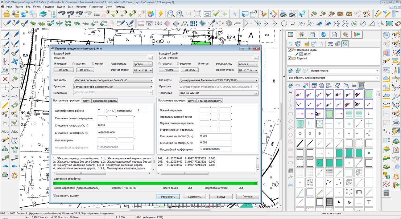
The mode "Recalculation of coordinates in text files" from the Map Computer task is improved. As the initial data the text files with coordinates in arbitrary coordinate system are used. Text files with coordinates can be loaded from XLS tables, databases and other sources. The description of a format of the used text file is presented in the electronic help for the mode. The choice of parameters of the input and output coordinate systems of a list of points is carried out in the following ways: by entering numerical values in the dialog; by using the EPSG code; from the list of coordinate systems of the XML file (for example, "LCS of the Subjects of the Russian Federation.xml").
All types of maps, projections and ellipsoids supported in the GIS Panorama system are available for recalculation of coordinates. The transformation of coordinates from the input user projection to the output projection is performed through geodetic coordinates on the common earth ellipsoid WGS84.
The dialog "Select Object" has been improved. On the bookmark "Metrics" the possibility of updating of object from files of formats: SHP/DBF, OGC GML, GeoJSON is added. You can update an object or only its metric through the items in the context menu "Update object metric" or "Update object". In the Map Editor, a mode for copying metric data of one map object into another object was added. The task is intended to perform actions on copying the coordinates from a specified object or group of selected objects.
A new way of a choice of square objects on a map - only on the object contour is added. The main mode of the object choice is the mouse-click inside the object or along its contour. This mode complicates the enumeration of objects if in one point there is a large number of areal objects. For example, areal objects of territories are displayed in the following order: City - District - Region. The choice of objects is performed in the reverse order: Region - District - City. With the main mode of a choice the city territory will be chosen only from the third time. At a choice of the areal object on the contour the city territory can be chosen from the first time. Customizing the mode of a choosing the areal objects is carried out through the main menu of the program:Options\Square objects choice on the contour.
The task "Search by name" has been improved. Possibility of line-by-line search or text marking by full (partial) coincidence is added. Multiline text can be loaded from a text file, pasted from a buffer, or entered in the appropriate field. For example, the mode allows you to select on the map all objects containing in the semantics of "Name" one of the lines of a multi-line list.
The restriction on the size of a multi-line title on the map is excluded. When a line longer than 126 characters is entered in the "Label editing" dialog, an service record with code 32860 with the entered text is created in the semantics of the object, and the link "# 32860" is saved in the label text. When editing text, an automatic updating the text of label and semantics is carried out. If the text becomes shorter than 126 characters, the service semantics will be deleted.
The task "Calculation of semantics by entering objects" is improved. The process of transferring the established semantic characteristics from entering objects into selected polygons is accelerated. The acceleration was achieved by improving the search algorithm for objects included in the polygon by determining their belonging by the calculated center of coordinates. When exporting a vector map to DXF and MIF\MID formats, the title text of the form #XXX is replaced with the value of the corresponding semantics.
The new version of the program is available for download in the section.


In KB "Panorama" the version 9 is developed. In the new version there are increased the productivity of the data analysis and speed of constructing tiles at the expense of creation of treelike structure of spatial data and possibility of cutting of tiles byrasters and matrixes "on the fly", without their preliminary transformation. The program added parameters for customizing the quality of generated tiles (map image the printer/screen, quality of graphics output, RAM consumption, and others). The list of supported matrixes for publishing data and keeping them in up-to-date state has been expanded. Ability is added to set the configuration directory using the config.xml file and install multiple copies of the program. Configuration files for project parameters and created matrixes are separated. Administrator interface is improved. There are added the parameters for tuning the performance of the service. Ability is added to select the format of the name and directory of the created tile: scale/row/row_column, scale/row/column, scale/column/row and others.
Panorama Imagery Service is a service designed to create and update tile pyramids in PNG, PNG8 or JPEG formats using spatial data managed by the program. Pyramids of tiles are published using OGC WMTS protocol by service the . As the clients of services, there can be various GIS supporting the OGC WMTS protocol and users of the program. Pyramids of tiles can be created on the base of a combination of digital vector maps, space and aerial photography, matrixes of elevations, data from geoportals and other data.
The new version of the program is available on the website in the section.
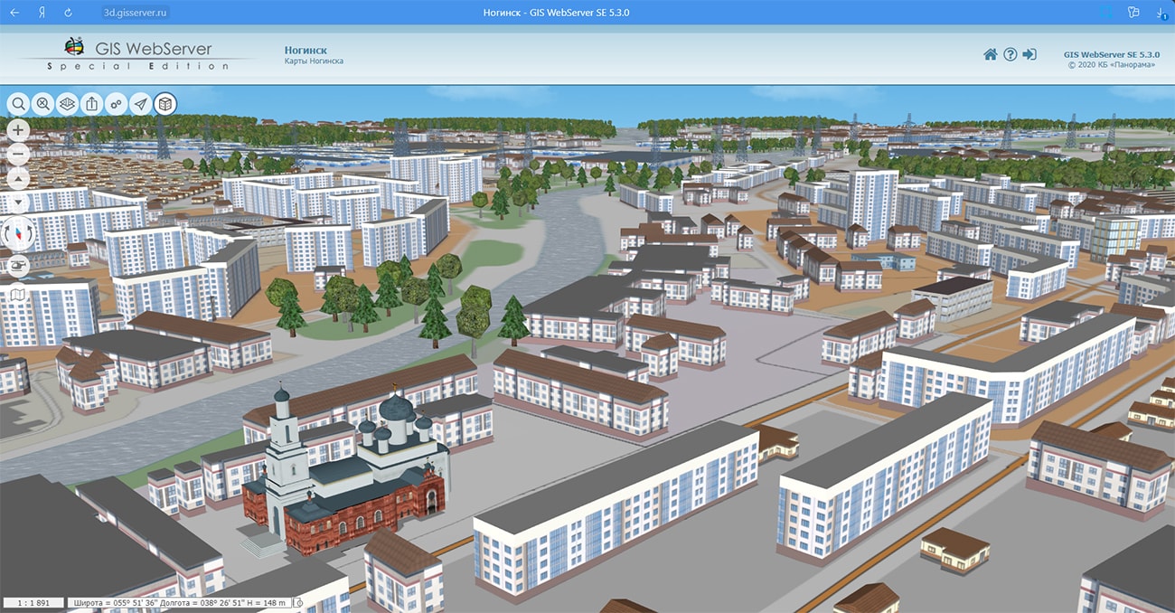


In KB "Panorama" the version 13.1.0 for the x64 platform is developed. In the new version of the program the tools of displaying geospatial data in various scales are improved. The map atlas provides a quick transition between overlapping maps of different scales, coordinate systems and projections. Atlas of maps can be represented as a tree of a group of projects. The group of projects includes various types of data - vector, raster and matrix maps, as well as map projects (MPT). By means of the module "Manager of maps" the convenient mechanism of systematization of metadata about cartographical resources in your local network is available. Manual and automatic search in the local network of various vector, raster and matrix maps, binary data of the SXF and TXF format, as well as classifiers and files of cartographic projects. The manager of maps provides conducting the user information about maps and hierarchical interrelation between them in a database. The manager of maps organises the representation of a database in the form of a tree and provides visualisation in various scales of vector, raster and matrix maps. The mechanism of Insets provides displaying a map, a raster or a matrix in the form of an illustration over open region of works. The data in the insert can have its own scale, projection, coordinate system, classifier, not related to the open region of work. The location of the inset in the work region, the scale of display and other parameters are customized in the "Embedded objects list" dialog on the "Inset" bookmark (View - Embedded objects list).
Support for the mechanism of pyramids of tiles allows to improve significantly quality of displaying the geospatial data for various scales. GIS Panorama Mini provides the displaying the packed pyramids of tiles stored in a database under the control of SQLite DBMS, in BIR, Mbtiles and other formats. Preparation of a pyramid of tiles is carried out in program by the vector maps, remote sensing data and matrixes of heights of a relief and terrain objects. Access to the pyramids of tiles is carried out both offline without the use of server applications, and in client-server mode through the using the OGC WMTS protocol or through the version 8.3 and higher.
In the new version of the program, the dialog "Object selection" has been improved. On the bookmark "Metric" there is added the ability to save the description of the object in file formats: SHP/DBF, OGC GML, GeoJSON. You can save the object through the menu item "Save Object" by pressing the right mouse button. There is added the ability to view the result of the description of the title format when using service characters and words as a tooltip when you hover over the title. A list of service symbols and words can be found by clicking on the "Service symbols" button.
In the task "Saving a vector map to graphic format files" the list of output file formats is expanded. Along with the BMP, TIFF, JPEG and RSW formats, the formation of a map image in a PNG file is added. A fragment of an electronic map document of any kind and composition, including vector maps, rasters and matrices, as well as geospatial data from external Internet resources (WMS and WFS services) can be saved. The ability to save the map image by the selected area, by the page format and by the dimensions of the selected objects, for example, by the dimensions of the frames of nomenclature sheets, has been implemented.
When you open a zip file containing data in the SXF exchange format and RSC, the vector map is automatically generated and opened. Zip files with vector maps can be generated on request in the .
The new version of the program is available for download in the section.


In KB "Panorama" the professional vectorizer version 13.1.0.2 for the x64 platform is developed. In the new version of the program, automated map generalization has been improved. The "Automated generalization of topographical maps" complex is used to convert a map of the source scale to a map of a smaller scale (destination scale). The program optimizes the algorithms for generalizing small objects - reconciling of objects adjacent to deleted ones. There are refined the files of parameters for the modes: formation of an output map, recoding of objects, adaptation of small objects, title of objects.
Processing of large regions of maps is accelerated. And with it there are performed a filtering and generalizing the contours of objects, transformation of the narrow areal rivers into linear ones, an assigning the thickness of the rivers (thickening from source to mouth), a restricting the boundaries of visibility of rivers and roads of low significance, selecting buildings in compact planning, a leveling the buildings along roads, a creating the objects of the mathematical basis, a signing the objects with new types of symbols according to the semantics of objects. The processing of small reservoirs has been accelerated, during the processing of which the search for adjacent cover objects (forests, meadows) and the uniting the removed small reservoirs with adjacent cover objects are performed.
In the new version in the “Map Editor”, the mode of editing the title created on the semantics of object has been improved. To change the text of the title, you can go to the source - the semantics of the object linked with the title. For correction of the displayed text in dialog of title editing, the "Title source" button is provided. By its pressing in the "Semantics" bookmark of "Select Object" dialog it is possible to set new value of corresponding semantics. When updating and saving semantics, the text of the linked titles will automatically be replaced with a new one in accordance with the specified display format. The automatic synchronization of the text of title linked to the semantics of the map object has been expanded. Creation of the titles linked with objects is carried out using the map editor tools: Create the title of line on semantic, Create the title on semantics ("Title" group). To synchronize the title text with the semantics of the linked object, special code records of the text in the title metric are used, which begin with the symbol "#". Code record can, for example, look like: "#9(~)\H=#4.1(~)" where there are indicated the links to semantics "Name" (9), "Absolute height" (4), transition to the next line "\" and number of digits of the fractional part of the real number ".1". In parentheses there are written the default values, or the sign of deleting the line "~" in the absence of semantics. If the object has both semantics (9 and 4) on the map, the linked title looks like: "Lukovo\H=123.4." In the absence of semantics 9, the title has the form: "H=123.4". A detailed description of the format for recording a string with examples is given on the help page:
The file format for storing the description of the models line of the map editor has been changed. The description of the models line is saved in the Log folder in the file of EDTX format.
When you open models saved in the EDT format, the file is automatically converted to the EDTX format. Each line of models has a user-defined individual name, which allows you to quickly navigate when choosing the desired object.
The dialog "Object selection" has been improved. On the bookmark "Metric" there is added the ability to save the description of the object in file formats: SHP/DBF, OGC GML, GeoJSON. You can save the object through the menu item "Save Object" by pressing the right mouse button.
There is added the ability to view the result of the description of the title format when using service characters and words as a tooltip when you hover over the title. A list of service symbols and words can be found by clicking on the "Service symbols" button.
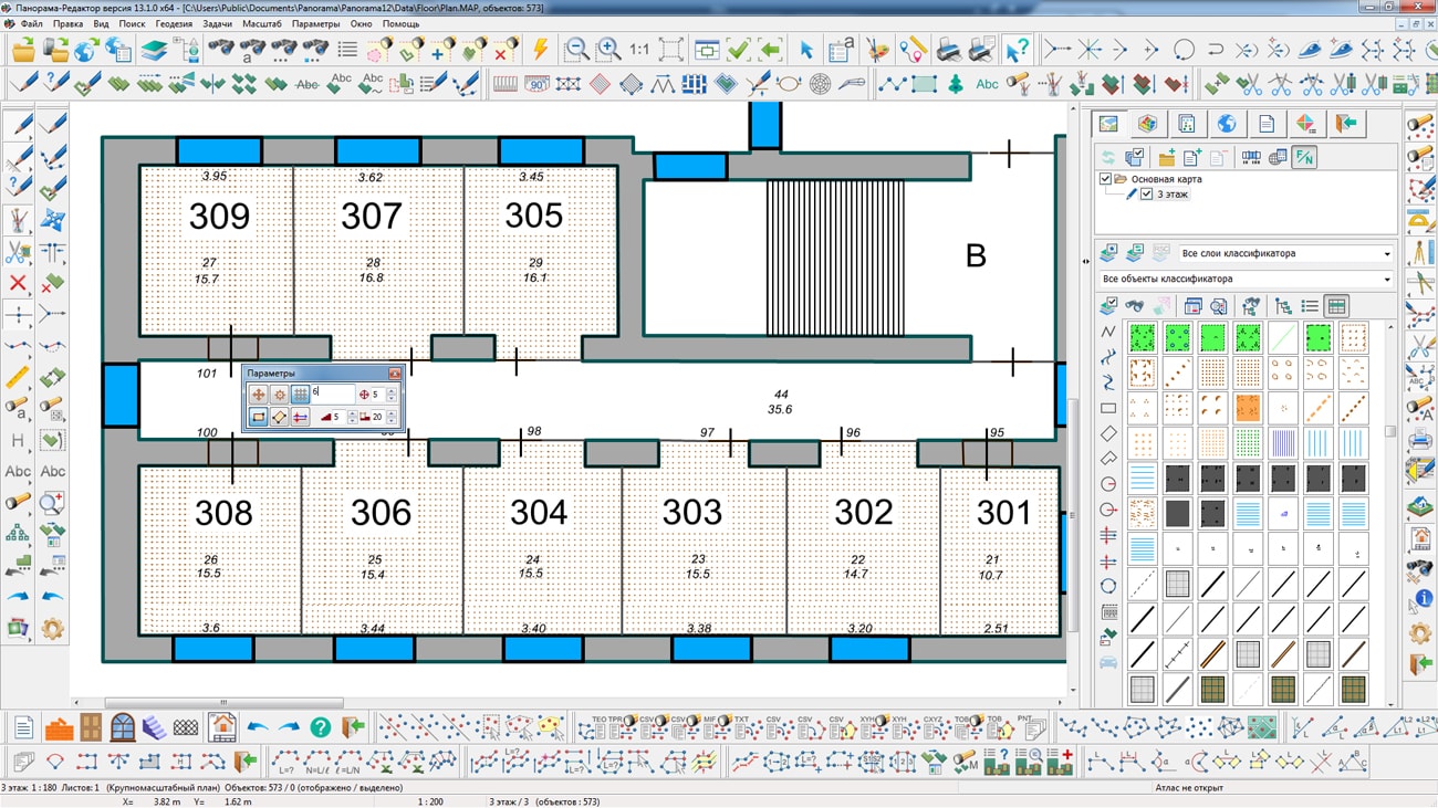
A new module "Floor Plan Editor " has been added to the "Geodesy Editor", which is a set of new specialized modes arranged in a separate toolbar. The module includes the basic functions necessary for the quick and high-quality creation of graphic documents of floor plans of buildings and constructions in the established form and accepted conventional symbols. The wizard for creating a new project allows by one-click to form a template of the graphic document with ready-made layout and footers (headers, corner stamps, etc.).
In the module “Map (plan) of a land management object”, when processing semantics containing the name of the MapPlan XML file, the functions of forming a short (when writing) and full file name (when reading) are added. Functions are added for correct copying of maps with links from one computer onto another one. The function of "intelligent" checking the geonyms of address element according to the scheme AddressInp_v05.xsd is developed, since there are no directories of types of address objects for the _AddressInp_v09.xsd scheme. At the input of the function, the name of the type of the addressable object, for example, "street", at the exit, the geonym "str". The function of checking geonyms is used in the dialog "Land survey plan" and "Map (plan) of the land management object" for updating the values of the customer address obtained from the cadastral database. So as the base is maintained simultaneously for all types of cadastral documents, the structured address can differ for the technical plan, a map (plan), a land survey plan.
In the task "Saving a vector map into files of graphic formats", the list of output file formats is expanded. Along with the BMP, TIFF, JPEG and RSW formats, the formation of a map image in a PNG file is added. A document fragment of a digital map of any kind and composition, including vector maps, rasters and matrixes, as well as geospatial data from external Internet resources (WMS and WFS services) can be saved. There is implemented the ability to save the map image by the selected area, by the page format and by the dimensions of the selected objects, for example, by the dimensions of the frames of nomenclature sheets.
The new version of the program is available for download in the section.


Ph.: +7 (495) 739-0245, +7 (925) 221-1603
www.gisinfo.ru | panorama@gisinfo.ru
105005, Russia, Moscow, Baumanskaya Street 7, building 1, office 229 (m. Baumanskaya)
Copyright © Panorama Group 1991 - 2024


 Mobile version
 Full version