Copyright © Panorama Group 1991 - 2024

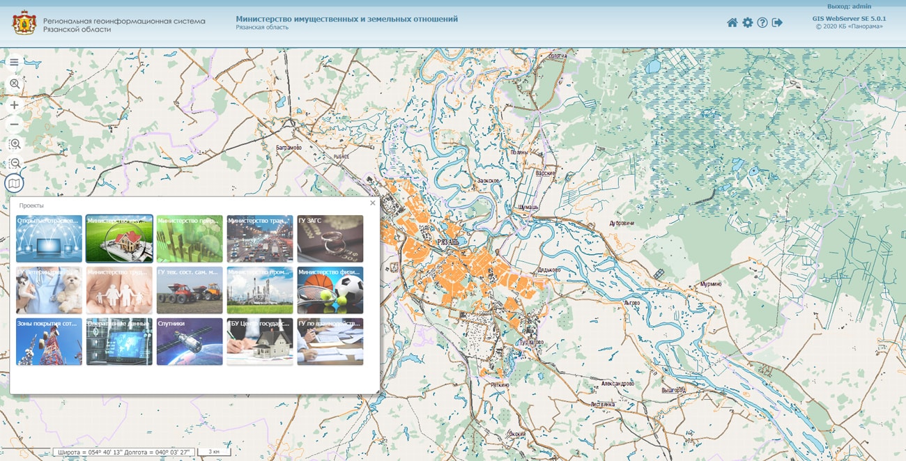
As part of the modernization of the existing regional geographic information system of the Ryazan region, the specialists of KB Panorama conducted training for representatives of the executive authorities of the Ryazan region, performing the functions of operators and analysts of the system. The modernized state information system "Regional Geographic Information System of the Ryazan Region" was built on the basis of serial software of KB "Panorama". The server part of the regional geographic information system includes the GIS Server, GIS Web Service SE, GIS WebServer SE. As a client application at the workstations of the system’s operators, the professional vectorizer the GIS "Panorama-Editor" with complexes of urban tasks and geodesy calculations is used. For users with the rights of "analyst", access to the system is carried out using a web application from a standard Internet browser.
The classes were organized by the Ministry of Digital Development, Information Technology and Communications of the Ryazan Region. The event was held in the period from February, 20 till February, 21st on the basis of collective work space the "Boiling point" in the city of Ryazan. The attendees listened to the basic course of applying the Panorama geographic information systems. They got acquainted with the interface of the modernized system, the rules for creating and publishing spatial data, were able to get answers to questions. The initial content of the RGIS was implemented by converting the data provided by the government of the Ryazan region from the SHAPE format into the internal format of the modernized RGIS RO, and publishing them on the system’s servers.


In KB "Panorama" the version 13.1.0 is developed. In the new version the requests for work with three-dimensional terrain models are added. The request of formation of a 3D-layer is implemented. Developers using can publish their own database of three-dimensional objects in db3d format, having transferred the necessary parameters to the service. In addition, to request information about an object, it is possible to display the templates visibility range of p3d library.
In the new version a processing of all requests is accelerated at the expense of creating the reduced xml files of settings for each layer. The program forms tiles by rasters and matrixes "on the fly", without preliminary data transformation. This saves time on additional data preparation. In the program the interface of the administrator is improved, interactive tips are added.
The new version of the program has expanded the ability to create pyramids of tiles for integration with existing information systems. The service can be embedded in data warehouses, simplifying the process of publishing tiles for a particular information system. Users can specify the format of the tiles names and the structure of their storage, for example, scale/row/row_column.png, scale/row/column.png, scale/column/row.png and others.
GIS WebService SE supports all international standards (OGC WFS, WFS-T, WMS, WMTS, WCS), with the help of which the transmission and display of spatial data is carried out. The program has the ability to issue tiles by any user or local coordinate system. The application is implemented on Windows and Linux platforms, is compatible with Apache, IIS and nginx web servers.
The new version of the program and documentation are available on the website in the section.


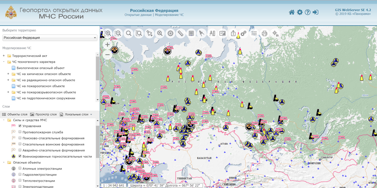
In KB "Panorama" the is updated. The new version of the geoportal uses the technology of connecting application libraries to the geo-service, which made it possible to model and evaluate the potential consequences of emergencies in various scenarios. When constructing an emergency model, the terrain features, relief, vegetation and weather conditions are taken into account. The geoportal contains systematic information about the units of the Ministry of Emergencies, rescue military units, potentially dangerous facilities and individual objects of transport infrastructure. When forming this data, information from open resources was used: the official website of the Russian Ministry for Emergencies, Wikipedia, Russia's Arms, Military Russia, OpenStreetMap and others.
The geoportal is designed for evaluation purposes, it demonstrates the capabilities of the serial software products of KB "Panorama" (, , GIS WebService SE) and is an example of their use. The geo-portal of open data of EMERCOM of Russia allows you to simulate the situation as a result of an emergency in the following scenarios: a terrorist attack, an emergency of technogenic (at biological, chemical, radiation-hazardous facilities and others) and natural characters (fire, flood, flooding, mudflows/landslides and others).
Algorithms for calculating the consequences of emergencies are implemented on the basis of guides and guidelines. With the obtained simulation results, various analytical tasks can be carried out: an estimating the number of buildings, personnel, population that fell into the affected areas; selection of objects at a given distance from the epicenter; checking transport accessibility to the epicenter of the accident; building a route to the epicenter of the accident; estimation of the approximate number of people who fell into the emergency zone, according to a given population density.
All results of modelling, including the spatial data, it is possible to print or save into a file for the subsequent use. In addition, the Geoportal provides standard capabilities for working with spatial data (working with a map, selecting and viewing a territory, selecting objects on a map, and others).
The presentation and the documentation on the Geoportal can be found on the website in the Download section. Geoportal of open data of EMERCOM of Russia is available on the company's website and is available at .


The KB "Panorama" systematized the experience of applying the software technologies "Panorama" to create and use spatial data in the field of automation of traffic control of vehicles.
Modern cars have long been able to brake and accelerate on their own, to determine their location and distance to obstacles. Cars are equipped with an increasing number of sensors and equipments of technical vision. To achieve the maximum level of vehicles automation and solving the growing transport needs in the world the are being developed. ITS is the result of combining modern modeling technologies, real-time control, as well as communication technologies.
The use of digital maps in ITS will allow to implement the autonomous movement of vehicles in adverse weather conditions, at night, without equipping the road infrastructure with expensive equipment, as well as to minimize operating costs for maintaining the system.
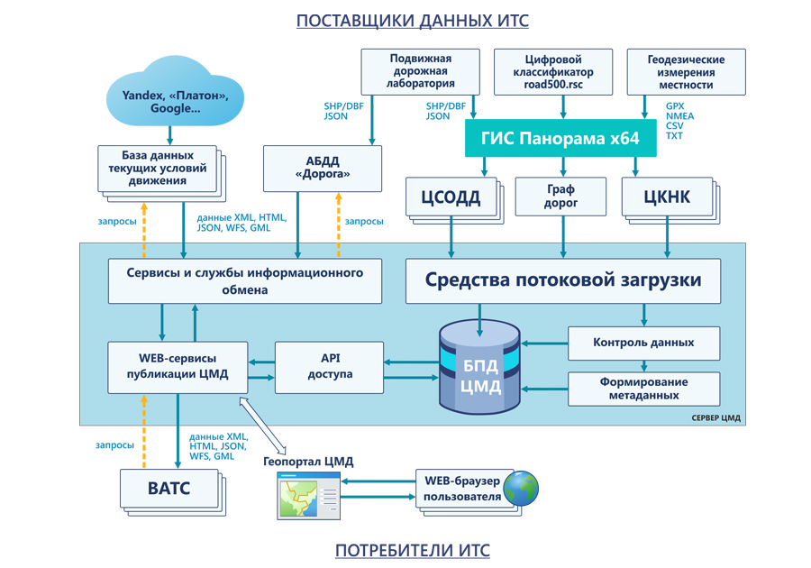
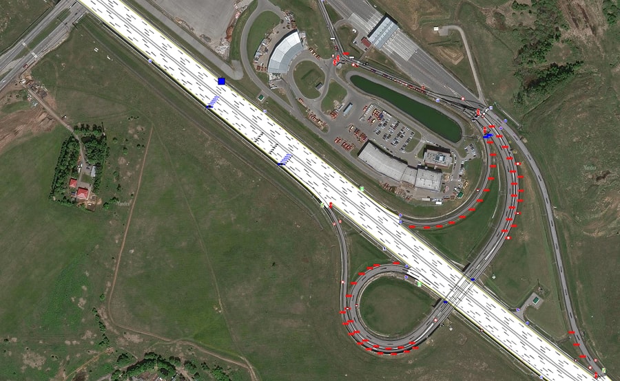
KB Panorama has tested technologies of creating, updating and publishing spatial data about structural elements of the road, lanes, road markings, road signs and traffic lights in the form of a digital road model (DRM). DRM database is implemented as a cloud service in which digital data about the road and other information that somehow affect the road situation are consolidated.
Technology of creating and using the DRM, described in the article, will provide developers of highly automated vehicles with high-precision digital maps and navigation data necessary for constructing planned lines of the car’s movement in a dynamically changing road-transport environment.
As part of the software for maintaining the DRM, several components should be distinguished. Automated technologies for preparation of digital information about the road are implemented in the . Web-services and services of publishing DRM data that support an information exchange with external databases and consumers of spatial data are implemented by means of and . and provide API and SDK tools for developing applications for controlling an automated vehicle based on DRM data. The catalog of spatial objects that characterize the elements of the road, road service, patterns and conditions of traffic is implemented on the basis of the digital classifier , which contains the necessary list of objects for creating objects and layers of DRM.
The article can be found on the website in the article section. KB "Panorama" invites all interested parties to scientific and technical cooperation to develop the functionality of the digital road model.


13-14 February, 2020 the was held in Moscow. As part of this event, the project manager of KB Panorama Alexander Kirichenko held a master class on the topic "Dynamic 3D-terrain models. Variants of creation and types of source data".
At the master class, the participants of the event were shown the capabilities of 3D modeling in the and software products, namely the construction of three-dimensional terrain models using a wide variety of source data: vector map, matrix of heights, a triangulation model of the relief and terrain, point cloud, three-dimensional models of objects, aerial photography data, three-dimensional tiles.
Also on the master class it has been told about the tile representation of three-dimensional data - about a format that contains a pyramid of the scales of a three-dimensional model in the form of small blocks for each level. The using this format allows you to solve the problem of large amounts of data and their transmission in the case of using WEB-applications.
The 11th International Scientific and Practical Conference turned out to be an excellent platform for the exchange of experience and acquaintance with the latest trends and innovations of Russian and foreign companies in the field of geodesy, mine-survey and aerial photography.


Ph.: +7 (495) 739-0245, +7 (925) 221-1603
www.gisinfo.ru | panorama@gisinfo.ru
105005, Russia, Moscow, Baumanskaya Street 7, building 1, office 229 (m. Baumanskaya)
Copyright © Panorama Group 1991 - 2024


 Mobile version
 Full version