Copyright © Panorama Group 1991 - 2024

In KB "Panorama" the version 8.4.2 is developed for operating systems CentOS and Astra Linux SE (Release "Smolensk"). In the new version a support of domain authorization for the is added. The mode of deleting tiles for the project is implemented. It allows you to delete tiles to certain territories, scales and matrixes that are specified in the program settings.
Panorama Imagery Service is a Linux service designed to create and update tile pyramids in PNG, PNG8 or JPEG formats using spatial data managed by the GIS Server program. Pyramids of tiles are published using OGC WMTS protocol by service the . As the clients of services, there can be various GIS supporting the OGC WMTS protocol and users of the program. Pyramids of tiles can be created on the base of a combination of digital vector maps, space and aerial photography, matrixes of elevations, data from geoportals and other data.
The program supports standard tile pyramids: GlobalCRS84Scale (standard matrix for representing spatial data in EPSG:4326 projection), GlobalCRS84Pixel (matrix for intuitive representation of spatial data), GoogleCRS84Quad (matrix compatible with Google data in EPSG:4326 projection), GoogleMapsCompatible (matrix compatible with Google data in EPSG:3857 projection, also used in Google Maps) and others. To read the source data, Panorama Imagery Service can connect to the GIS Server or open data sets on the local network. The program monitors data changes - by the transaction log for vector data, by the time of updating raster and matrix data, and automatically updates the tiles on which the changes occurred.
New versions of programs are available on the website in the section.


In KB "Panorama" the version 13.0.4 for the x64 platform is developed. In the new version a support of the international format OGC 12-128r15 GeoPackage version 1.2.1 (*.gpkg) is added. This format is a SQLite 3 database that stores tiles of various formats, their coordinate system, matrixes of descriptions, and metadata. GeoPackage format is used in applications for providing access to spatial information: maps, images, matrixes of elevations. The format can be used in cloud storages and for simplifying the exchange of information, since all data is stored in one file.
Ability is added to receive and display packed pyramids of tiles from . Pyramids of tiles can be in BIR, Mbtiles formats, stored in a database managed by SQLite DBMS. Pyramids of tiles can be created in the program, including in the environment of the , using vector maps, remote sensing data and matrixes of heights of relief and terrain objects. Access to tiles pyramids can be offline without the use of server applications, as well as in client-server mode through via the OGC WMTS protocol or through the GIS Server. When accessing client-server mode, the tiles that were accessed are automatically cached on the client's computer, similar to working through a web browser.
The task of connecting geoportals has been improved. List of connected geoportals is updated. Data from geoportals can be connected as a background to user data for solving various application tasks (validation, printing reports, reconciling data and others). Vector layers obtained by the OGC WFS protocol can serve as initial data. The program supports a monitoring of changes and tracking moving objects in a near-real time mode. If the geoportal or service supports the OGC WFS-T transaction protocol, then the task allows not only to receive, display objects and monitor their updates, but also to edit them, transferring changes to the server to display these changes to other clients. Displaying all geoportals is accelerated. There is added the ability to display and save data from Rosreestr geoportals without duplicating signatures on the screen in various projections, including for local coordinate systems. Displaying the Rosreestr geoportal is significantly accelerated upon repeated calls.
Support for GSK-2011 and PZ-90.11 coordinate systems is implemented. The creation of maps in the GSK-2011 system, the conversion of projections and coordinate systems of maps, matrixes and rasters is provided. The new national coordinate systems were adopted by Decree of the Government of the Russian Federation of December 28, 2012 N 1463 "On unified state coordinate systems".
A new type of maps, Topographic PZ-90.11 (Pulkovo2017), based on the use of the ellipsoid PZ-90.11 and the Gauss-Krueger projection, has been added into the "View Passport" task. As system of heights the Average level of world ocean (geoid) corresponding to the EGM2008 model is established. Support for a new type of map is added into the task "Creation of rule". In the dialogs for recalculating and displaying the coordinates of the current point on the map, the coordinate system PZ-90.02 was replaced by PZ-90.11.
Into the map passport the property "Use alternative fonts" is added. This property is necessary, for example, for the correct display of OSM maps in national languages using the standard classifier map5000m.rsc. The classifier includes topographic fonts in which not all language encoding are implemented. The installation includes the altfonts.xml file, in which for such fonts the alternative fonts supporting the required encoding are specified.
To split the set of point signs into groups and display them, the algorithm of an automatic clustering is implemented. In the "Classifier Editor" tools of clusters description are added. Description includes: views of objects relating to each type of cluster, cell sizes vertically and horizontally, semantics code to indicate the current number of objects in the cluster, view of a conventional sign of a cluster, a limiting percent of magnifying the size of a cluster's sign and the limiting number of objects, and the limiting number of objects, corresponding to the maximum size of the cluster sign. The cluster symbol can be programmable, that allows you by various ways to set off a type of a cluster and to change properties of a sign depending on number of objects in a cluster (signature of the number, size of a sign, brightness). When grouping in a virtual cluster cell more than one object of a given type, their conventional signs will automatically be replaced by a conventional sign of the cluster, the center of which will have an average coordinate of the objects included in it. When you change the scale, the cluster configuration automatically changes. Maps with clusters customized in the RSC classifier are automatically supported in all desktop and web applications, as well as in applications developed in the and GIS Constructor.
Algorithm of creating signatures of objects according to their semantic characteristics is changed. At updating semantics of object there are automatically updated the corresponding semantics of all signatures created for the object in the "Map Editor" or in the task of "Creation of titles by objects semantics". The task of creating titles by objects semantics, taking into account the processing of multipolygons selected on the map, has been improved. A title is formed for each contour that belongs to the multipolygon and is put in accordance with the dialog settings.
"Map Editor" task is improved. In the mode of creating a linear object, a new option "Add to object" is added, which provides a joining of the created contour to the contour of the already existing linear object on the map. The mode of the map editor "Paste & Cut - Cut of polygon object by object" has been improved. When cutting a polygon object, support of multipolygons is added. When an ordinary polygon object is cut, the result is ordinary polygonal ones. When cutting a multipolygon, the result is a multipolygon.
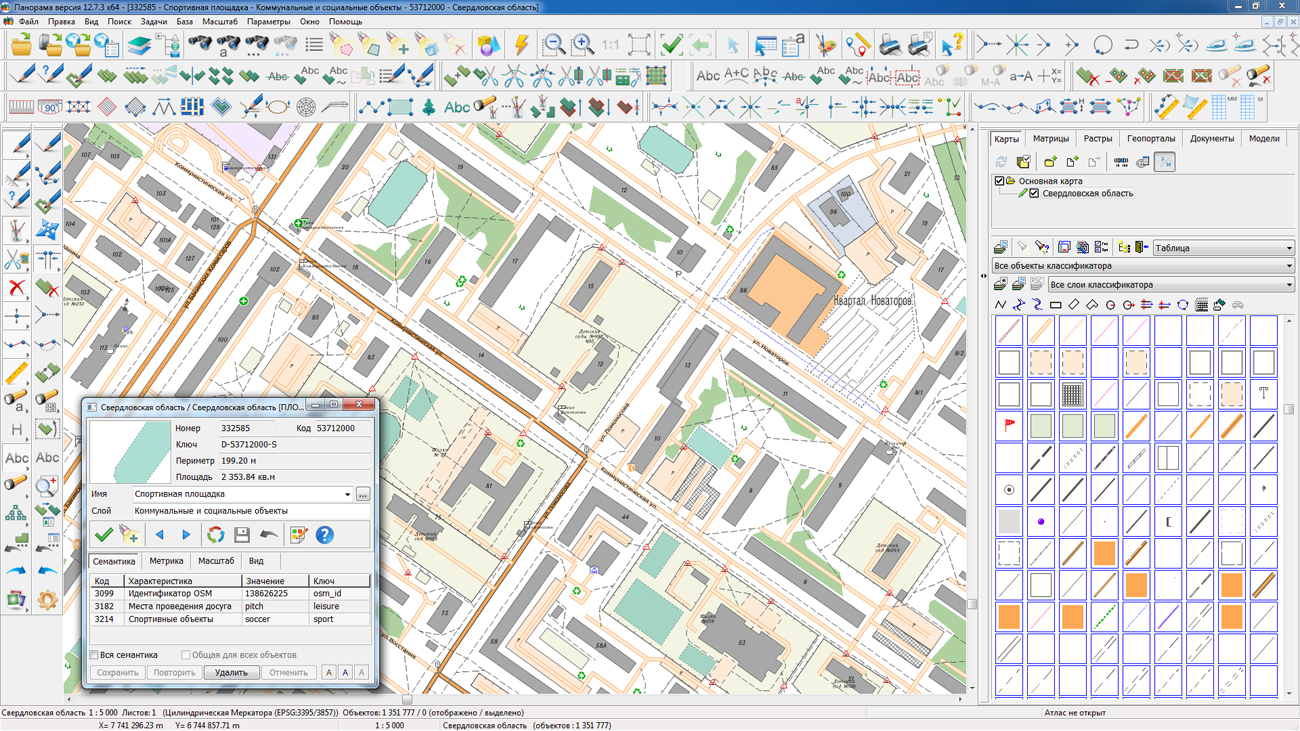
"Select Object" dialog has been improved. In order to increase the information content of the object’s scheme, the color of the contours has been changed in the "Metric" bookmark: for ordinary objects, the main contour now is displayed in blue color, and subobjects - in pink color. In multipolygons, all external contours are displayed in blue color, the rest - in pink. The new color scheme allows you visually to verify the correctness of the subobjects occurrence. On the "Semantics" bookmark, the ability to disable sorting of the object characteristics table has been added. Data will be displayed in the sequence of their addition to the map object. Enabling/Disabling sorting can be done through the "Sort" context menu item.
The mode "Image shutter" is improved. By means of this mode the analysis of various overlapping opaque images can be made by shifting their borders. Possibility to apply the "shutter" for matrixes and geoportals is added. The mode is started through the main menu View/Image shutter. The task "Saving vector map into file of BMP, TIFF, RSW format" has been improved. The mode of page-by-page saving of the map image to graphic files by page format is added.
Updating the Panorama Mini version 12 to version 13 till June, 1st, 2020 is free for users who purchased the Panorama Mini version 12 after December, 1st, 2018, as well as for those who have a valid technical support agreement for version 12. The new version of program is available for download on the page.


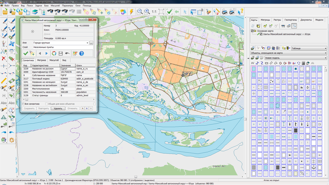
On the geoportal , the maps of regions of the Ural Federal District, which were formed according to OpenStreetMap data, were updated.
The composition of the maps includes Kurgan, Sverdlovsk, Tyumen, Chelyabinsk Oblasts, the Yamalo-Nenets Autonomous Okrug and the Khanty-Mansi Autonomous Okrug - Yugra. The source data was obtained from the website. For work with the maps it is possible to use the program of or other software products of KB "Panorama".
The maps were led to the modernised classifier of large-scale plans of scale 1: 5 000 (map5000m.rsc). Publishing of updates in bank of spatial data is made by using the program of . Publishing contents of bank of spatial data on the geoportal and data access for downloading are implemented by means of .
Free maps on the basis of OpenStreetMap data are available for download on the page "Digital maps and images".


In KB "Panorama" the version 13.0.4 for the x64 platform is developed. In the new version, automated generalization of maps has been improved. Processing of large regions of maps is accelerated. On a computer with average performance the conversion of 36 sheets of a map of scale 1: 100 000 into 9 sheets of a map of scale 1: 200 000 takes less than two hours (up to 15 minutes per sheet). And with it there are performed a filtering and generalizing the contours of objects, transformation of the narrow areal rivers into linear ones, an assigning the thickness of the rivers (thickening from source to mouth), a restricting the boundaries of visibility of rivers and roads of low significance, selecting buildings in compact planning, a leveling the buildings along roads, a creating the objects of the mathematical basis, a signing the objects with new types of symbols according to the semantics of objects.
The task "Quarters generalisation" has been refined, designed for automatic uniting of closely located same-type quarters and adjustment of quarters with linear objects of the road network. In order to eliminate the contradictory overlap of the objects of the map of the derived scale, there are added the processes of adjustment of quarters and removing the buildings in the area of quarters with black filling.
In the new version of the program, algorithms of generalization for small objects have been improved: adjustment of objects adjacent to deleted ones. The processing of small reservoirs has been accelerated, during the processing of which the search for adjacent cover objects (forests, meadows) and the uniting the removed small reservoirs with adjacent cover objects are performed. The uniting is performed if there is the presence of a significant area (contour) of adjacency of the analyzed objects. Parameters files for the modes have been refined: formation of output map, recoding objects, generalization of small objects, title of objects. Customizing filters of the objects processed at formation of an output map is simplified. The new method allows to perform faster and more flexible customization of the objects types copied onto the output map. The quality of signing the names of settlements has been improved: a new algorithm for selecting a place for signing perform a search for the most free place from the contours. New signatures are implemented in the form of vector symbols containing complex signatures that are used to sign characteristics of bridges, dams, locks, dams, ferries, fords, forests, settlements and other objects.
Complex signatures allow you to automatically adapt the type of signature taking into account the presence or absence of objects characteristics. It is enough to add, delete or change the semantics of such symbol and the type of signature automatically changes. This approach allows you to completely replace obsolete types of characters with the localization of "Mixed" with vector symbols. Classifiers 25t05gm.rsc, 50t05gm.rsc, 100t05gm.rsc, 200t05gm.rsc, 500t05gm.rsc, 1m05gm.rsc are updated, and also there are added the files of parameters of maps generalization of scales from 1: 25 000 to 1: 1 000 000.
The program has expanded the list of tasks for automated processing of vector maps in the task "Map processing according to the scenario." The new task "Correction of object metrics" is developed. It performs the removal of outliers and double points in the specified tolerance; removal of the initial and final coincident segments of linear objects; cutting contours of linear objects at the junction points; cutting contours of areal objects at points of junction and self-intersection; conversion of multilines into simple lines; transformation of multipolygons into simple areal objects with internal subobjects.
In the program of correcting the metric of objects a processing of multipolygons is accelerated. For example, time of correcting the metric of a test set of maps with more than 3 million objects was reduced from 5 hours to 30 minutes, and about 50 thousand topology errors were corrected. Upon completion of work, the number of corrected errors is recorded into the log "View error". The task is called through the main menu: Tools - Map processing by scenario - Correction of object metrics.
The task "Checking the quality of a vector map" has been improved. Checking the vector map is carried out in accordance with the selected control scheme containing a list of types and parameters of checking. The format of the checking parameters schema file has been changed from binary CXM to textual XML. In the \Control.Dot\ folder, the XML files for control parameters schemes with the extension * .CXML have been updated.
In the task "Vector map Checking", the automatic correction of the metric of areal and linear objects has been improved. In polygon objects, there are removed the outliers and vertex duplications, all types of self-crossings, crossings of contours and errors of locations of subjects are corrected. Adjacent contours of one object are combined, intersecting contours are divided into separate objects. In the objects having errors of locations of subjects, the description order is corrected: the subject having the maximum area becomes the main one, the subjects located inside other subjects are stored into separate objects. In linear objects, there are removed the outliers and vertexes duplications, coinciding segments, the self-joining is corrected (joining of non-consecutive segments of one contour). The contours having the self-joining, are divided into separate objects. To correct the metrics of objects, it is necessary to perform "Check of self-crossings and locations of subjects" in the "Edit" mode. The corrected objects have a topologically correct metric description, which provides the calculation of correct areas, simplifies the construction of road network graphs, and allows you to combine and cut areas of vector data according to specified conditions. Automatic correction of the metrics of map objects allows you to speed up the processing of vector maps obtained from any sources that do not have a strict standard for checking the metric information.
In the task the "Checking the quality of a vector map" according to a control scheme, tools of checking the metadata of the map are added. Metadata is formed by the task the "Map passport" according the standards of ISO 19115:2003, Geographic information - Metadata and ISO/TS 19139, Geographic information - Metadata - XML schema implementation. Metadata is saved in the XML format as a separate file onto each sheet of the map. Metadata allows you to enter additional information about the map (data on the manufacturer, data on the technology of creation) and use it in the conducting the automated banks of the spatial data.
The task "Check of vector map quality" has been improved. Checking the vector map is carried out in accordance with the selected control scheme containing a list of types and parameters of checking. The format of the checking parameters schema file has been changed from binary CXM to textual XML. In the \Control.Dot\ folder, the XML files for control parameters schemes with the extension * .CXML have been updated.
In the task "Vector map Checking", the automatic correction of the metric of areal and linear objects has been improved. In polygon objects, there are removed the outliers and vertex duplications, all types of self-crossings, crossings of contours and errors of locations of subjects are corrected. Adjacent contours of one object are combined, intersecting contours are divided into separate objects. In the objects having errors of locations of subjects, the description order is corrected: the subject having the maximum area becomes the main one, the subjects located inside other subjects are stored into separate objects. In linear objects, there are removed the outliers and vertexes duplications, coinciding segments, the self-joining is corrected (joining of non-consecutive segments of one contour). The contours having the self-joining, are divided into separate objects. To correct the metrics of objects, it is necessary to perform "Check of self-crossings and locations of subjects" in the "Edit" mode. The corrected objects have a topologically correct metric description, which provides the calculation of correct areas, simplifies the construction of road network graphs, and allows you to combine and cut areas of vector data according to specified conditions. Automatic correction of the metrics of map objects allows you to speed up the processing of vector maps obtained from any sources that do not have a strict standard for checking the metric information.
In the task the "Checking the quality of a vector map" according to a control scheme, tools of checking the metadata of the map are added. Metadata is formed by the task the "Map passport" according the standards of ISO 19115:2003, Geographic information - Metadata and ISO/TS 19139, Geographic information - Metadata - XML schema implementation. Metadata is saved in the XML format as a separate file onto each sheet of the map. Metadata allows you to enter additional information about the map (data on the manufacturer, data on the technology of creation) and use it in the conducting the automated banks of the spatial data.
In the "Checking the quality of a vector map" task, the output of reporting documents into an HTML file is added. Outputting reports into HTML file allows generating reporting documents without using office programs. There is added the ability to run multiple instances of the GIS "Panorama-editor" program for execution of checking various vector maps with issuing reports in HTML format (a report in MS Word is executed from only one program). The output of reporting documents into an HTML file is based on a pre-prepared template. For the "Checking the quality of a vector map" task, a template for the HTML document mapcontr.htm was created in a text editor. The template defines the main structure of an HTML document and contains its settings, such as fonts, page settings, formatting, and styles. Upon termination of working the "Checking the quality of a vector map" program, the HTML report files with the control results for each card and the final report containing information on the results of processing all the maps will be saved in the directory for placing output maps and reporting documents.
In GIS "Panorama-editor" a support for GSK-2011 and PZ-90.11 coordinate systems is added. The creation of maps in the GSK-2011 system, the conversion of projections and coordinate systems of maps, matrixes and rasters is provided. The new national coordinate systems were adopted by Decree of the Government of the Russian Federation of December 28, 2012 N 1463 "On unified state coordinate systems".
A new type of maps, Topographic PZ-90.11 (Pulkovo2017), based on the use of the ellipsoid PZ-90.11 and the Gauss-Krueger projection, has been added into the "View Passport" task. As system of heights the Average level of world ocean (geoid) corresponding to the EGM2008 model is established. Support for a new type of map is added into the task "Creation of rule". In the dialogs for recalculating and displaying the coordinates of the current point on the map, the coordinate system PZ-90.02 was replaced by PZ-90.11. Into the map passport the property "Use alternative fonts" is added. This property is necessary, for example, for the correct display of OSM maps in national languages using the standard classifier map5000m.rsc. The classifier includes topographic fonts in which not all language encoding are implemented. The installation includes the altfonts.xml file, in which for such fonts the alternative fonts supporting the required encoding are specified.
On the basis of classifiers of digital topographic maps (DTM) of 1:50 000 and 1: 100 000 scales, modernized classifiers 50t05gm.rsc and 100t05gm.rsc were prepared, intended for the automated generalization and automation of the creating and updating DTM. The modernized DTM combines the basic properties of a topographic and navigation map. With the help of the task "Creating of passages in settlements" and prepared classifiers, streets and passages in settlements are automatically formed. Tools of automated control and correction of the quality of digital maps provide control of the topology according to the metrics of objects. By created streets and passages along with the road network objects when solving Navigation tasks a graph of roads is formed. A complete road and street network in settlements increases the degree of automation in the forming the maps of smaller scales (generalization). Significantly the composition of the layers is reduced by combining the data of the same type. The order of displaying objects in the classifier is set in accordance with the priority of the layers and the priority of objects in the layer, which makes it unnecessary to use additional layers. In the properties of some objects that are not used in practice when creating a DTM based on remote sensing data, the sign "Obsolete object" is set. Obsolete objects are not displayed in the objects list of the "Create object" dialog, unless the "Obsolete objects" field is enabled. This allows you to store in classifier the objects from the obsolete classifiers "05" and "09" for compatibility, but not display them when creating and updating the map to facilitate the selection of actual types of objects. For the automatic formation of labels using the task "Automatic labels alignment", the corresponding labels are customized according to the semantics of the objects.
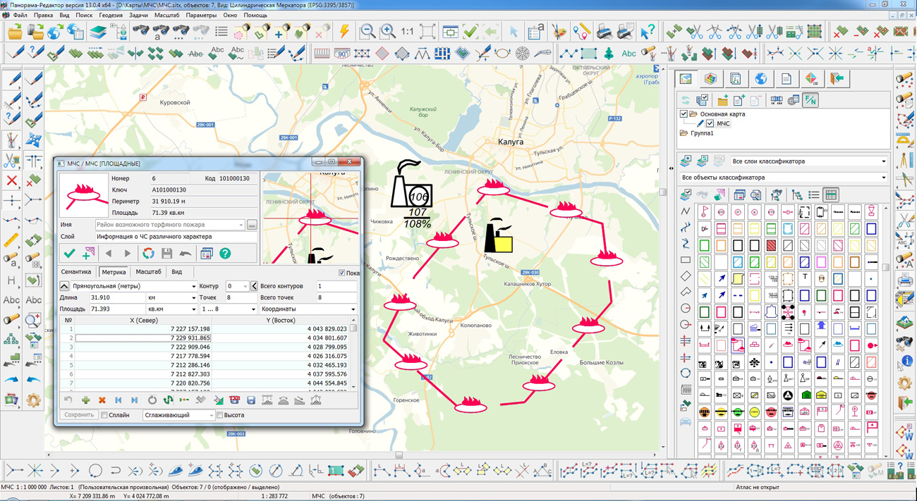
Into the program composition the classifiers of conventional symbols emercom.v2.rsc and map5000m.rsc are added. The classifier of conventional symbols emercom.v2.rsc has been developed for the preparation of cartographic information in the field of civil defense, prevention and liquidation of consequences of emergencies by governing bodies, civil defense forces and the unified state system for the prevention and liquidation of emergency situations (RSChS). In the classifier there is implemented a general list of layers, objects and attributive characteristics of objects that provide solutions to problems in the field of civil defense, prevention and liquidation of consequences of natural and man-made emergencies. The emercom.v2.rsc classifier contains the information: about territories, zones, objects, forces and means affecting the problems of organization, planning and conduct of measures for civil defense and the protection of the population and territories; about the forecast and operational situation arising in the course of military conflicts or as a result of these conflicts, as well as during emergencies of a natural and man-made nature; about planning and conducting activities on civil defense, prevention and liquidation of consequences of emergencies of a natural and man-made character. The modernized classifier of large-scale plans of a scale 1: 5 000 the map5000m.rsc is designed to create topographic plans of cities or city plans in the local coordinate system of scales of 1: 5000, which can be used in territorial planning, maintaining the land and property cadastre, in architecture and urban planning. The codes of the Information Cartographic Support approved by the Head of the VTU General Staff of the Russian Federation in 2007 are taken as the basis of object codes.
The task of connecting geoportals has been improved. List of connected geoportals is updated. Data from geoportals can be connected as a background to user data for solving various application tasks (validation, printing reports, reconciling data and others). Vector layers obtained by the OGC WFS protocol can serve as initial data. The program supports a monitoring of changes and tracking moving objects in a near-real time mode. If the geoportal or service supports the OGC WFS-T transaction protocol, then the task allows not only to receive, display objects and monitor their updates, but also to edit them, transferring changes to the server to display these changes to other clients. Displaying all geoportals is accelerated. There is added the ability to display and save data from Rosreestr geoportals without duplicating signatures on the screen in various projections, including for local coordinate systems. Displaying the Rosreestr geoportal is significantly accelerated upon repeated calls.
To split the set of point signs into groups and display them, the algorithm of an automatic clustering is implemented. In the "Classifier Editor" tools of clusters description are added. Description includes: views of objects relating to each type of cluster, cell sizes vertically and horizontally, semantics code to indicate the current number of objects in the cluster, view of a conventional sign of a cluster, a limiting percent of magnifying the size of a cluster's sign and the limiting number of objects, and the limiting number of objects, corresponding to the maximum size of the cluster sign. The cluster symbol can be programmable, that allows you by various ways to set off a type of a cluster and to change properties of a sign depending on number of objects in a cluster (signature of the number, size of a sign, brightness). When grouping in a virtual cluster cell more than one object of a given type, their conventional signs will automatically be replaced by a conventional sign of the cluster, the center of which will have an average coordinate of the objects included in it. When you change the scale, the cluster configuration automatically changes. Maps with clusters customized in the RSC classifier are automatically supported in all desktop and web applications, as well as in applications developed in the and GIS Constructor.
Algorithm of creating signatures of objects according to their semantic characteristics is changed. At updating semantics of object there are automatically updated the corresponding semantics of all signatures created for the object in the "Map Editor" or in the task of "Creation of titles by objects semantics". The task of creating titles by objects semantics, taking into account the processing of multipolygons selected on the map, has been improved. A title is formed for each contour that belongs to the multipolygon and is put in accordance with the dialog settings.
"Map Editor" task is improved. In the mode of creating a linear object, a new option "Add to object" is added, which provides a joining of the created contour to the contour of the already existing linear object on the map. The mode of the map editor "Paste & Cut - Cut of polygon object by object" has been improved. When cutting a polygon object, support of multipolygons is added. When an ordinary polygon object is cut, the result is ordinary polygonal ones. When cutting a multipolygon, the result is a multipolygon.
"Select Object" dialog has been improved. In order to increase the information content of the object’s scheme, the color of the contours has been changed in the "Metric" bookmark: for ordinary objects, the main contour now is displayed in blue color, and subobjects - in pink color. In multipolygons, all external contours are displayed in blue color, the rest - in pink. The new color scheme allows you visually to verify the correctness of the subobjects occurrence. On the "Semantics" bookmark, the ability to disable sorting of the object characteristics table has been added. Data will be displayed in the sequence of their addition to the map object. Enabling/Disabling sorting can be done through the "Sort" context menu item.
The mode "Image shutter" is improved. By means of this mode the analysis of various overlapping opaque images can be made by shifting their borders. Possibility to apply the "shutter" for matrixes and geoportals is added. The mode is started through the main menu View/Image shutter.
The task "Saving vector map into file of BMP, TIFF, RSW format" has been improved. The mode of page-by-page saving of the map image to graphic files by page format is added.
GIS "Panorama-editor" allows to create high-quality digital maps with use of the raster image of source cartographic materials, of materials of Remote Sensing of the Earth (results of air and space photographing of a terrestrial surface), and also of results of field geodetic measurements. Program includes advanced tools of quality check of a created vector map, tools of editing the raster image, tools of transforming of raster and vector data.
Updating the "Panorama-editor" version 12 to version 13 till June, 1st, 2020 is free for users who purchased the "Panorama-editor" version 12 after December, 1st, 2018, as well as for those who have a valid technical support agreement for version 12. The new version of program is available for download on the page.


In KB "Panorama" the version 5.1 is developed for operating systems Windows, Astra Linux, CentOS. The new version adds the ability to authorize users through the State Services portal with use of the Unified Identification and Authentication System (ESIA). Using his account on the State Services portal, the user gets limited access to application's resources published by the service.
GIS WebServer SE supports the following authentication types: 1) Authentication by means of the application (login and password are transmitted to the server in base64 encoding); 2) Server authentication - authentication is performed by means of the web-server (basic, digest) or of the operating system (Kerberos authentication, ActiveDirectory); 3) External authentication - authentication is performed using GIS WebService SE or using tokens (access tokens) based on the OAuth 2.0 protocol (ESIA). This protocol allows the application to grant access to user resources on another service. The protocol eliminates the need at each reference to transfer to the application a login and a password of the user and to limit a data set transferred to the application.
In the new version the toolkit of developing the Web-applications the has been improved, which expands capabilities of GIS WebServer SE and can be integrated into other information systems. Access to data (images, vector maps and terrain information) is provided by web-services using common OGC protocols and ISO standards. Service of GIS WebService SE (OGC WMS/WMTS) provides spatial information in the form of graphic images. Various types of high-altitude data are used as a digital elevation model: matrixes (in the formats SRTM, GeoTIFF, IMG, MTW), TIN-models, point cloud and others. At request the most accurate data onto a specified terrain site with a given resolution is automatically sampled. To transfer data of the digital terrain model to the Web, the WCS protocol is used. The relief data is represented as tiles and cached on the client.
As a source of spatial data, the can be. It provides the collection, storage, search and delivery of spatial data in exchange formats, a displaying the state of the data bank in the form of maps-schemes, the automated formation and updating of geo-covers.
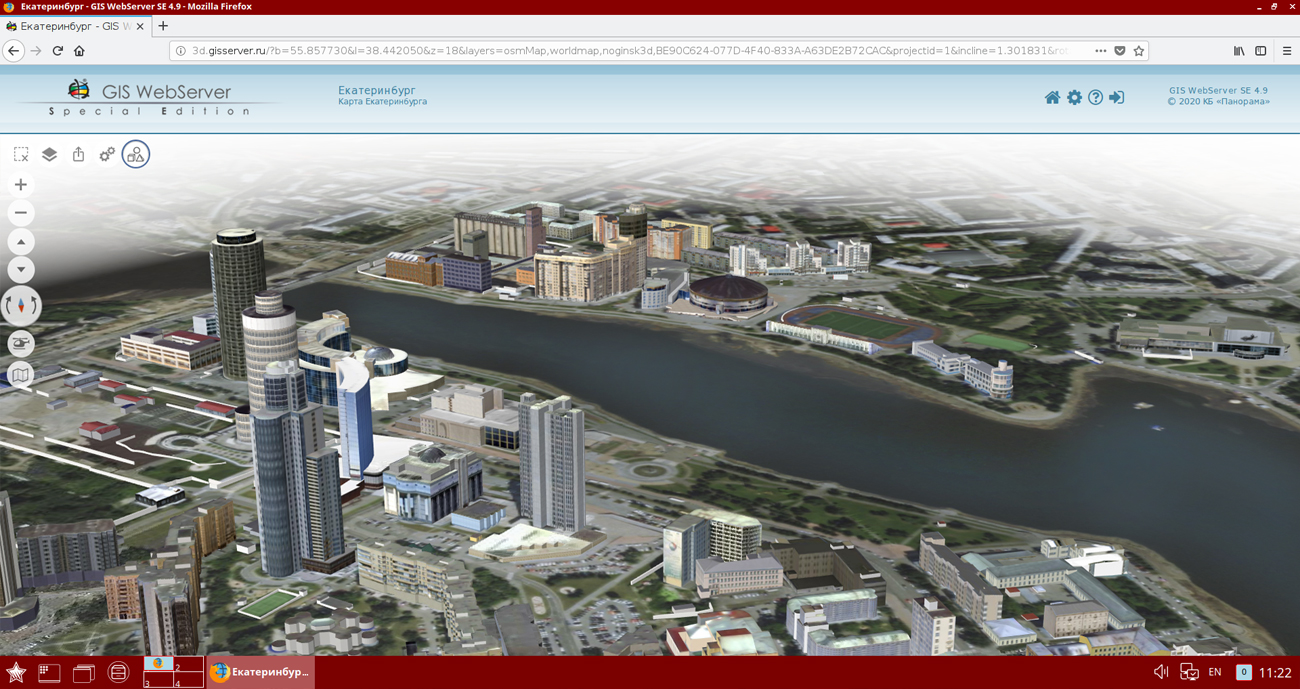
GIS WebServer SE is used in the construction of closed corporate systems to ensure the protection of data having a security classification or a trade secret. GIS WebServer SE is certified for Level 2 of absence of undeclared capabilities. The new version of the program expands the application's capabilities in solving problems of analysis, management and long-term planning of the territories development. GIS WebServer SE is implemented using the toolkit of GIS WebToolKit SE, which can be used in development tools that use the JavaScript.
The new version of the program is available on the website in the section.


Ph.: +7 (495) 739-0245, +7 (925) 221-1603
www.gisinfo.ru | panorama@gisinfo.ru
105005, Russia, Moscow, Baumanskaya Street 7, building 1, office 229 (m. Baumanskaya)
Copyright © Panorama Group 1991 - 2024


 Mobile version
 Full version