Copyright © Panorama Group 1991 - 2024

In KB "Panorama" the document "Schemes and drawings of the technical plan. Description of technology" is prepared. This document contains a description of the technology for creating schemes and drawings of the technical plan using the software of the x64 and application the Complex of geodesy calculations (Geodesy editor).
Creation of schemes, drawings and plans is performed in digital form when preparing the technical plan. Most often they are used to receive graphic files in PDF or JPEG format for subsequent use when filling out report sections of a technical plan. The technology for creating schemes and drawings of the technical plan of the property describes both the procedure for preparing files for the graphic part of the technical plan, and the procedure for preparing a digital work map of the technical plan used in the automatic formation of a report and an electronic XML document.
The document provides a technological scheme and enlarged stages of preparation of schemes and plans. The procedure for creating a digital map for a scheme and a drawing or a plan is described. There are described the requirements for indicating the parameters of the coordinate system used for schemes and drawings or for plans of real estate. The modes for obtaining source data from various sources are indicated: digital cadastral map of the municipality; cadastral plans of territories and extracts from the USRT; scanned plan of a storey, building, construction; results of cadastral measurements.
The procedure is given for digitizing the boundaries of the property when preparing a digital work map of technical plan. The digital model of the property is described used at automation of the filling a text report and an electronic XML document. The user’s actions for various options for the formation of the technical plan are described in detail: a property with several external contours, the formation of parts, changing information about the property and its parts, and more. Variants of the metric description of several contours of one real estate object using sub-objects, multipolygons and sets of objects are given. The features of creating and selecting objects on a digital map with the simultaneous formation of two or more real estate objects are indicated.
For the first time, the procedure for preparing a digital model of a building (construction) and premises and/or parking spaces in it with using a set of digital maps, including a drawing of a real estate object and several plans of floors containing the boundaries of the premises (parking spaces), is described. The features of preparing a set of digital maps for a linear construction located in several cadastral districts are described.
You can familiarize yourself with the document "Schemes and drawings of the technical plan. Description of technology" on the website in the Download section.


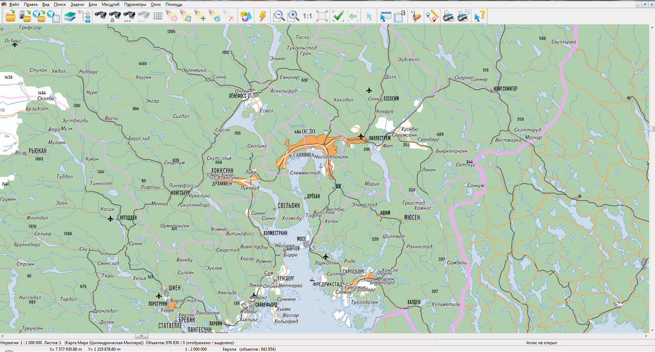
KB "Panorama" prepared a digital geographical map of scale 1: 1 000 000 in format SXF onto the territory of the Kingdom of Norway. obtained according to information from the website has served as source for map's preparation.
The map contains information about the quantity of inhabitants for cities and the names of settlements in Russian. As additional materials the World map of scale 1: 5 000 000 and data of were used. The map was led to the classifier of geographical maps of scale 1: 1 000 000 (1mogk13g.rsc). It can be used for the general estimation of the terrain and studying of an environment, an ensuring of educational process, as a basis for creation of geographical maps of smaller scale, thematic and special maps and solving other tasks.
The map is distributed free according to the free . Digital geographical map of scale 1: 1 000 000 in format SXF is available for downloading on page the "Digital maps and images".


On October 28-30, the was held in the capital of South Korea. The organizers of the conference are the companies Racurs (Russia) and SI Imaging Services (South Korea). The event was attended by more than 40 private and state-owned companies from 10 countries. The conference was held in the format of plenary sections, when participants, united by one topic, alternately make presentations and then enter into discussion.
At the conference, KB "Panorama" company was introduced by project manager Alexander Kirichenko. In the first report "Software solutions of KB Panorama for Smart City development", the was demonstrated - combining , and other programs into a single analytical geographic information system, the main purpose of which is to monitor the current situation and assisting in making managerial decisions in a region or city.
The second report is devoted to the topic "Innovations in cartography: automatic interpretation, generalization, multiscale map", where the main emphasis was placed onto the developing technology for the automated creation of small-scale maps based on larger-scale maps. Already today, specialists of KB Panorama have achieved a result when, on a computer with an average productivity, converting 36 sheets of a map of scale 1: 100,000 into 9 sheets of a map of scale 1: 200,000 takes up to 15 minutes per sheet, i.e. less than two hours.
In total in eight plenary sections of conference the 32 reports were presented, in which participants talked about the achievements of their companies over the past year, so the conference "From imagery to digital reality" proved to be an excellent platform for sharing of experiences and getting acquainted with the latest industry trends.


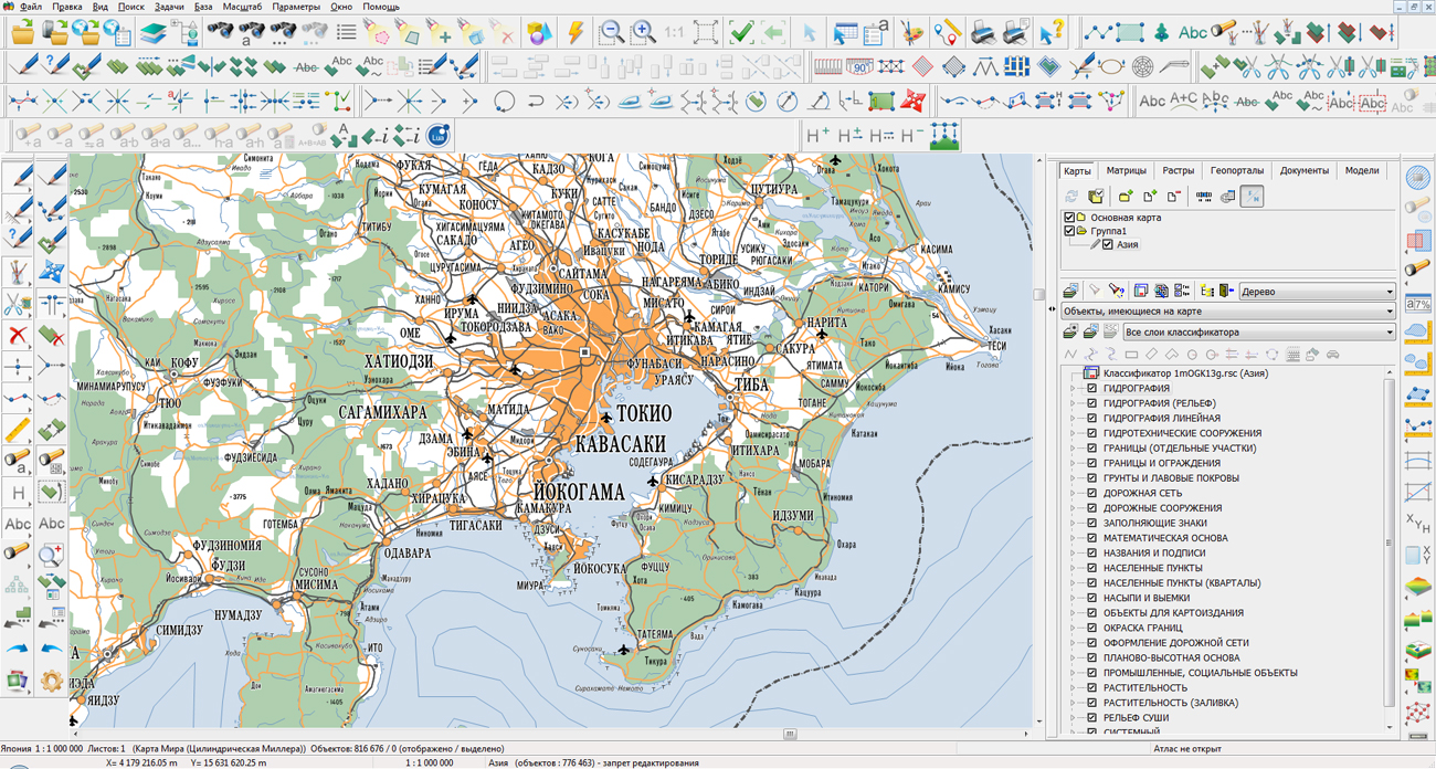
In KB "Panorama" the generalization of settlements titles for digital geographic maps of scale 1: 1 000 000 in the SXF format, formed according to (www.gis-lab.info), was performed. As a result of generalization, the general appearance of the maps is improved and the superimposition of titles for any scale is eliminated.
The maps were led to the classifier of geographical maps of scale 1: 1 000 000 (1mogk13g.rsc). Maps were led to the classifier of geographic maps of scale 1: 1 000 000 (1mogk13g.rsc), were supplemented by information on the quantity of inhabitants for cities and by the names of settlements in Russian. It can be used for the general estimation of the terrain and studying of an environment, an ensuring of educational process, as a basis for creation of geographical maps of smaller scale, thematic and special maps and solving other tasks. Maps are distributed free according to the free .
Digital geographical maps of scale 1: 1 000 000 in format SXF are available for downloading on page the "Digital maps and images".


In KB "Panorama" the (RSE) version 4.2 is developed. The new version improves the processing of requests for obtaining data of large volume. Speed of forming the archive with data is increased. Data can be received via HTTP protocol or through an exchange folder. Ability is added the to select the mode of archiving spatial data. The location of data in the archive and the exchange folder can be at the same nesting level or with subdirectories. There is implemented the ability to obtain geodata on request, with different parameters for the archive formation.
The list of logged user actions has been expanded. Creation of separate log with the list of deleted data sets is added. Logging of the request execution process is implemented. A report is generated from the user's actions log, which can be printed using browser tools.
Within the framework of a single geoinformation space, the Data Bank of digital maps and remote sensing data realises gathering, storage, search and delivery of the spatial data in exchange formats. The spatial data selected by means of the program can be placed for the multiuser access on the and be published according to the international standards OGC WFS, WFS-T, WMS, WMTS, WCS on application server the . Users can access data from both a thin client (by means of ) and from desktop applications (, ). The databank of digital maps and remote sensing data provides construction of cloud warehouse of spatial data, provision of access to these data, the automated formation and updating of geo-covers. The current state of spatial data is displayed by means of maps-schemes that are maintained for each type of stored data: vector maps, remote sensing data, elevation matrixes and terrain models. It provides remote placing the sets of spatial data into file warehouse, keeping versions of stored sets, updating maps-schemes of data availability, the automated collection and formation of metadata, and the formation and updating of geo-covers. Automated collection and formation of metadata is performed according to the standards of ISO 19115: 2003, Geographic information - Metadata and ISO/TS 19139, Geographic information - Metadata - XML schema implementation. The reduced copies of data images are automatically formed, checksum of files and completeness of data sets are checked.
The new version of the program is available for download on the page.


Ph.: +7 (495) 739-0245, +7 (925) 221-1603
www.gisinfo.ru | panorama@gisinfo.ru
105005, Russia, Moscow, Baumanskaya Street 7, building 1, office 229 (m. Baumanskaya)
Copyright © Panorama Group 1991 - 2024


 Mobile version
 Full version