Copyright © Panorama Group 1991 - 2024

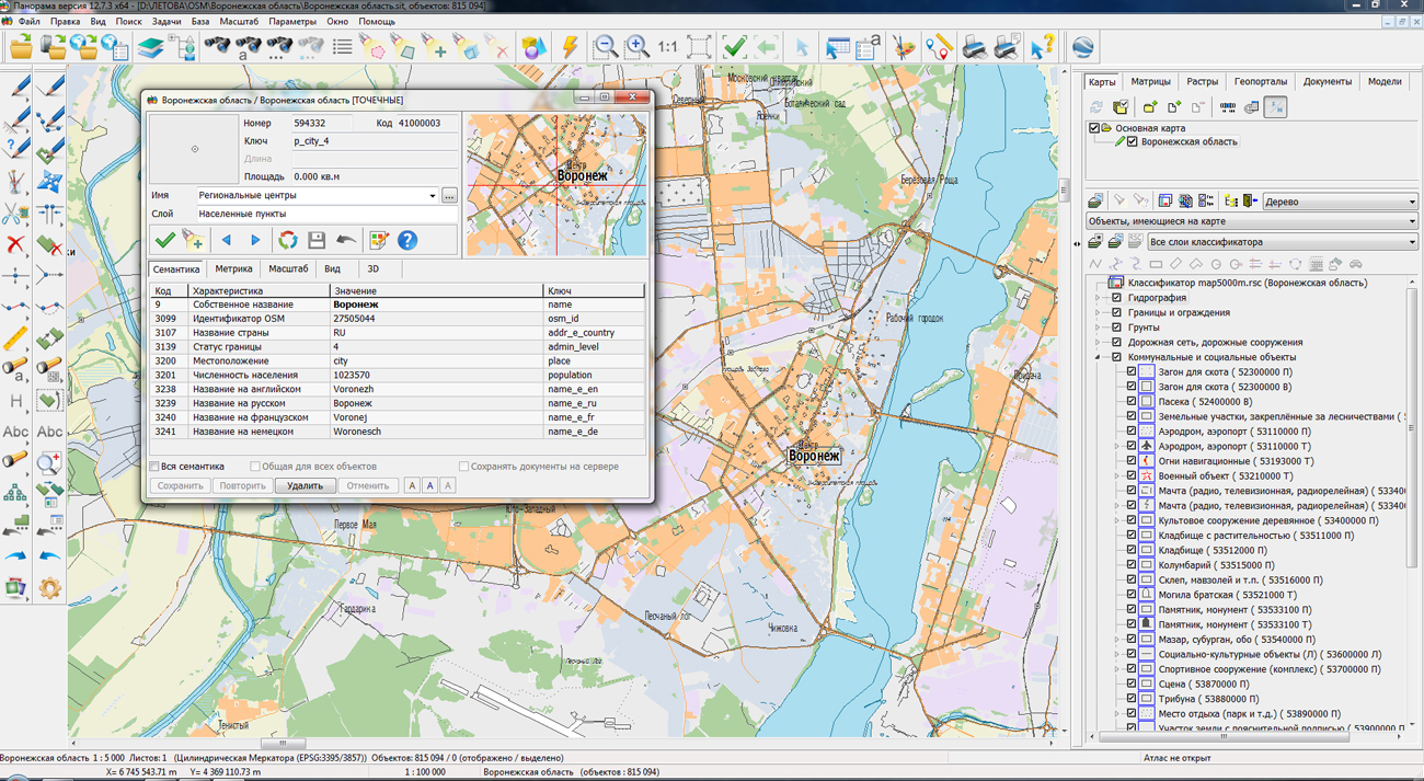
On the geoportal , the maps of Belgorod and Voronezh regions, which were formed according to OpenStreetMap data, were updated. Source data were obtained from the website. For work with the maps it is possible to use the program of or other software products of KB "Panorama".
The maps were led to the modernised classifier of large-scale plans of scale 1: 5 000 (map5000m.rsc). Publishing of updates in bank of spatial data is made by using the program of . Publishing contents of bank of spatial data on the geoportal and data access for downloading are implemented by means of .
Free maps on the basis of OpenStreetMap data are available for download on the page "Digital maps and images".


In KB "Panorama" the version 12.7.3 for the x64 platform is developed. In the new version, automated generalization of maps has been improved. Processing of large regions of maps is accelerated. On a computer with average performance the conversion of 36 sheets of a map of scale 1: 100 000 into 9 sheets of a map of scale 1: 200 000 takes about two hours. And with it there are performed a filtering and generalizing the contours of objects, transformation of the narrow areal rivers into linear ones, an assigning the thickness of the rivers (thickening from source to mouth), a restricting the boundaries of visibility of rivers and roads of low significance, selecting buildings in compact planning, a leveling the buildings along roads, a creating the objects of the mathematical basis, a signing the objects with new types of symbols according to the semantics of objects. The processing of small reservoirs has been accelerated, during the processing of which the search for adjacent cover objects (forests, meadows) and the uniting the removed small reservoirs with adjacent cover objects are performed. The uniting is performed if there is the presence of a significant area (contour) of adjacency of the analyzed objects.
Customizing filters of the objects processed at formation of an output map is simplified. The new method allows to perform faster and more flexible customization of the objects types copied onto the output map. The quality of signing the names of settlements has been improved: a new algorithm for selecting a place for signing perform a search for the most free place from the contours. New signatures are implemented in the form of vector symbols containing complex signatures that are used to sign characteristics of bridges, dams, locks, dams, ferries, fords, forests, settlements and other objects. Complex signatures allow you to automatically adapt the type of signature taking into account the presence or absence of objects characteristics. It is enough to add, delete or change the semantics of such symbol and the type of signature automatically changes. This approach allows you to completely replace obsolete types of characters with the localization of "Mixed" with vector symbols.
Classifiers 25t05gm.rsc, 50t05gm.rsc, 100t05gm.rsc, 200t05gm.rsc, 500t05gm.rsc, 1m05gm.rsc are updated, and also there are added the files of parameters of maps generalization of scales from 1: 25 000 to 1: 1 000 000 that correspond to the specified classifiers. Parameter files for composite processes of maps generalization have been prepared.
Display of vector symbols in the program is improved. New symbols automatically arrange the signatures of settlements, which may contain the name, number of inhabitants and a code of administrative value. Previously, these signatures were performed by three separate signatures that at increasing the image of a map led to integrity violation of signatures complex of the one settlement. New complex signatures preserve the relative position of all the signatures of the complex when scaling the map image, and also allow you to specify the position of the complex with a single operation. New symbols have been added to the classifiers 50t05gm.rsc, 100t05gm.rsc, 200t05gm.rsc, 500t05gm.rsc, 1m05gm.rsc, which are used to create maps of scales from 1: 50,000 to 1: 1 000 000.
There is added a support for service semantics the UTC BEGINNING DATE (DAYS PASSED), code 32859. Semantics automatically counts the number of days that have passed since a given date. It can be used to control the type of symbol, depending on the number of passed days. An example of a symbol is included in the shape\shape.sitx demo map.
Dialogs for editing conventional symbols of objects are improved. There are added the modes for copying from one object and inserting into another one of any conventional symbol through the clipboard. A new type of conventional symbol is added: shift line of type the "Color glass". For lines of the type "Set of elements", the ability is added to change the color of all line elements simultaneously and swap the elements. Into dialog of editing a vector symbol the additional marking with the center in a point of a binding is added, which allows you to speed up the process of creating and editing of images of vector symbols.
The task "View passport" has been improved. Into the "Preservation metadata in XML" dialog, the option "Save overview image" has been added, which allows you to create a map overview image in PNG format (filename.preview.png). The image of the map is built on the base scale of a map measuring 768 by 768 pixels. The "Data list" task has been improved. In item the Metadata of matrixes, rasters, while saving metadata in XML, there is added the ability to form an overview image of matrixes, rasters in PNG format.
Support of the international format OGC 12-128r15 GeoPackage version 1.2.1 (*.gpkg) is added. This format is a SQLite 3 database that stores tiles of various formats, their coordinate system, matrixes of descriptions, and metadata. GeoPackage format is used in applications for providing access to spatial information: maps, images, matrixes of elevations. The format can be used in cloud storages and for simplifying the exchange of information, since all data is stored in one file.
Task of check of vector map quality is improved. When improving, the protocol for generating error messages was unified in the of versions 11 and 12, as well as in the program . Support is provided for control schemes prepared in the version the GIS "Panorama" 11 (CXM). Reports by results of execution of checking the vector maps are formed on the basis of standard HTML-templates. Ready-made reports can be opened in any web browser and printed on A4 sheets. Replacing the DOC report format onto HTML allows you to ensure the independence of the program from the availability of MS Word on your computer, as well as increase the speed and reliability of reports formation.
Modes are improved for adding maps, matrixes or rasters into the work region. If the parameters of the coordinate system/projection of the added data and the open area do not match, a request is issued to convert the coordinate system/projection with the ability to select one or all files. Depending on the response of the operator, data with a mismatching coordinate system will be transformed to the coordinate system of the document and added to it or opened without change with the conversion of the coordinate system "on the fly".
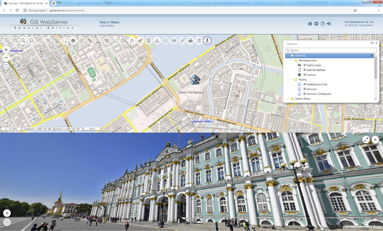
As part of data examples included in the installation of the GIS, the map of Noginsk generated according to OpenStreetMap data, has been updated. The map was led to a modernized classifier of large-scale plans of a scale 1: 5 000 map5000m.rsc. The classifier is designed to create topographic plans of cities or city plans in the local coordinate system of scales of 1: 5000, which can be used in territorial planning, maintaining the land and property cadastre, in architecture and urban planning. The codes of the Information Cartographic Support (IKO) approved by the Head of the VTU General Staff of the Russian Federation in 2007 are taken as the basis of object codes. The map is formed within the boundaries of the Bogorodsky urban district. Map signatures are generated using the task of Automatic labels alignment. A library of 3D-models of terrain's objects map5000m.p3d has been added to the classifier. In library there are created about three hundred kinds of templates for objects of layers: "Constructions, buildings", "Industrial objects", "Municipal and social objects", "Public objects", "Communications", "Borders and fences", "Road net, road constructions", "Vegetation", "Hydrography". To the two-dimensional types of objects there are assigned the templates of types: near, detailed, and far, less detailed. In the complete set with a map there are delivered: a database example in DBF and PostgreSQL format, a road graph, a relief elevation matrix, a database of three-dimensional models of historic city buildings in DB3D format. Into the map project the documents in Word format, raster documents and a map of borders of the Moscow Region were added.
The new version of the program is available on the site in the section.


In KB "Panorama" the version 12.5.1 is developed. In the new version a support of the international format OGC 12-128r15 GeoPackage version 1.2.1 (*.gpkg) is added. This format is a SQLite 3 database that stores tiles of various formats, their coordinate system, matrixes of descriptions, and metadata. GeoPackage format is used in applications for providing access to spatial information: maps, images, matrixes of elevations. The format can be used in cloud storages and for simplifying the exchange of information, since all data is stored in one file.
In the new version a support of the packed pyramids of tiles in BIR format is added, that are stored in a database under the control of SQLite DBMS. This format is an array of SQLite databases in which tiles are stored. Tiles are stored in png, jpg, png8 or bmp formats. The bmp format represents tiles by the size 65х65 pixels containing data about elevations (digital matrixes of elevations). By dividing the entire Earth's surface into several databases, it is possible to carry out a faster search for tiles.
Pyramids of tiles, according to these formats, can be created in the program, including in the environment of the , using vector maps, remote sensing data and matrixes of elevations of relief and terrain objects.
In the new version of the service, there are expanded the possibilities for working with the transaction log and various types of requests: obtaining 3D terrain models, obtaining vector tiles, obtaining metadata by the classifier. New formats are added for output of the spatial data - SXF/TXF.
GIS WebService SE supports all international standards (OGC WFS, WFS-T, WMS, WMTS, WCS), with the help of which the transmission and display of spatial data is carried out. The program has the ability to issue tiles by any user or local coordinate system. The application is implemented on Windows and Linux platforms, is compatible with Apache, IIS and nginx web servers.
The new version of the program and documentation are available on the website in the section.


In KB "Panorama" the "Workstation of Agronomist" version 12.7.3 is developed. In the new version the interface is optimised and technologies are improved for storing information about monitoring the fields. Information on agricultural land, posted in the database of agricultural enterprises, includes information on soil composition, weather conditions, crop rotation, the condition of crops and crop cultivation technologies. Modern technologies provide monitoring of crops using satellite-based materials of fields monitoring. To do this, it is necessary to process and analyze large volumes of images hosted on various servers in the data cloud of a particular operator of space data. This task is performed by the Geosys geoservice, the requests to which are formed by the "Workstation of agronomist".
By results of requests execution the matrixes of vegetation indices and zoning maps are formed. The data are loaded into branch base of agrarian GIS and are stored both in the special matrixes characterising value of an index in each cell of the established size, and in the form of time series of averaged values for each contour of the arable land. together with the implements structured storage of large amounts of data, sorted by category and time. "Workstation of Agronomist" provides the possibility of remote, multi-user, authorized access to current state data and fields monitoring.
Sorting data according to measurement time allows you to build a slice of information about crop growth on a specific date or on the removal of nutrients from the soil in different years, taking into account crop rotation. Using visualization tools, you can view matrixes of various indicators and graphs of their changes. Graphs are constructed on averaged values for the entire contour of the work area or for a given point. The storage and processing of matrixes and time series for agrochemical indicators, vegetation indices, crop yields, phytosanitary indicators, meteorological data and other monitoring indicators is supported.
Displaying the values of the matrixes at the point under the cursor allows you to visually analyze the changes of the indicator when moving the mouse cursor over the map of agricultural land. To build graphs of changes of the selected indicators, several matrixes are used that correspond to different points in time.
New analysis tools, integrated with the big data warehouse, make it possible to identify local areas of arable land that differ in the level of plant development and provide the ability to quickly make decisions aimed at increasing productivity and preventing plant death.
The new version of the program is available for download in the Download section.


By the invitation of the , specialists of KB "Panorama" took part in the seminar . The meeting discussed the regulatory and methodological foundations and topical issues of creating the federal state information system the "Unified Fund of geological information on subsoils" (FSIS "UFGI"). One of the important discussed issues was the formation of a single information space in terms of geological information and the organization of information exchange between the funds and systems of Rosnedra, subsoil users and consumers of geological information.
The presentation "Scientific and technical aspects of integration of funds of the spatial data" emphasizes that the formation and development of a single information space of the Russian Federation is the inter-branch and inter-regional problem. In the report the current state of automation of conducting funds and databanks in various departments is reflected.
The formation of a single information space is associated with the implementation of the spatial data infrastructure, geoservices and geoportals for request and reception of the spatial data from suppliers - holders of funds. The use of OGC web services, such as the WMS and WMTS web map service, the WCS web coverage service and the WFS web function service, allows various information systems to receive and use spatial data in a unified form for further analysis, visualization and planning.
The developed by KB Panorama, fully complies with modern requirements and is intended for loading, storing and issuing various types of spatial data and materials. The complex is already used for conducting the state fund of digital cartographical products in FSBI "Center for Geodesy of Cartography and SDI". The functionality of the complex is constantly expanding, in addition to digital maps, a conducting the database of engineering surveys and technical reports with a high level of automation of technological processes is maintained.
Ph.: +7 (495) 739-0245, +7 (925) 221-1603
www.gisinfo.ru | panorama@gisinfo.ru
105005, Russia, Moscow, Baumanskaya Street 7, building 1, office 229 (m. Baumanskaya)
Copyright © Panorama Group 1991 - 2024


 Mobile version
 Full version