Copyright © Panorama Group 1991 - 2024

From 26 to 28 June 2019 in the Kyrgyz Republic was held a seminar . The event was organized by the of the Ministry of Agriculture and Land Reclamation of the Kyrgyz Republic and the .
The leading Russian companies working in the field of geodesy, cartography and aerial photography took part in the international seminar. The specialists of KB "Panorama" presented technologies for creating and updating digital topographic maps based on data from unmanned aerial vehicles using and other software products of KB.
Representatives of Russian companies demonstrated to Kyrgyz specialists the latest technologies for using remote sensing data obtained from unmanned aerial vehicles to create accurate cartographic materials. In the process of work the participants discussed the practical and economic aspects of operating unmanned aerial vehicles and processing the results of the survey.
The seminar consisted of theoretical and practical parts. The theoretical part was held on the first day and included reports on the latest software developments for photogrammetric data processing, the creation of cartographic products and the construction of spatial data infrastructure.
The second day was devoted to aerial photography. During the field part of the workshop, the participants got acquainted with the whole chain of aerial photography using the SuperCam unmanned system: from preparing a geodetic control to directly performing the flight task.
On the third day of the workshop all stages of processing performed on the eve of aerial photography were demonstrated. They included the processing of navigation data, photogrammetric operations, the creation of digital cartographic products and placing it on the WEB-services. The technology and methods of processing orthophotomaps were presented when compiling digital topographic and cadastral maps and plans using the GIS "Panorama". The participants noted the high efficiency of the event, during which they familiarized themselves with the technological solutions and best practices of their Russian colleagues.

The completed its work. Specialists of KB "Panorama" took part in a number of events of the scientific and business program of the Forum. Within the scope of the round table , organized by the National Defense Management Center of the Russian Federation, the report "Exchange of spatial data within the scope of interdepartmental interaction" was presented. The round table reviewed the achieved results and discussed the problematic issues of the transition to the Russian software and hardware platforms when organizing interdepartmental information interaction. It was noted that for effective informational interdepartmental interaction it is necessary to form a single regulatory and technological documents that are mandatory for all departments, including the introduction of a unified system of classification and coding of information. An important direction of import substitution is the formation of a single data transmission network for public authorities with high capacity and information protection.
At conference , organised by the Military Topographical Directorate of the General Staff of the Russian Armed Forces, participants discussed the promising areas for improving the systems for creating, processing, analyzing and communicating spatial data to the troops. The topical tasks of the development of geo-information space in the framework of the national program "Digital Economy of the Russian Federation" and proposals for creating a single geo-information space of the Armed Forces of the Russian Federation were considered. In the report "Opportunities of civil universities in training specialists for the purpose of geodetic and navigation support of the Armed Forces of the Russian Federation", presented by Siberian State University of Geosystems and Technologies, it was noted that the training is conducted using . The university management expressed its appreciation to KB "Panorama" for providing academic licenses for the training of topographers on preferential terms.
The outcome of the conference and the round table were the proposals developed for the development of the effectiveness of topographic, geodetic and navigation support for the Armed Forces of the Russian Federation and the organization of interdepartmental information interaction in the exchange of spatial data.


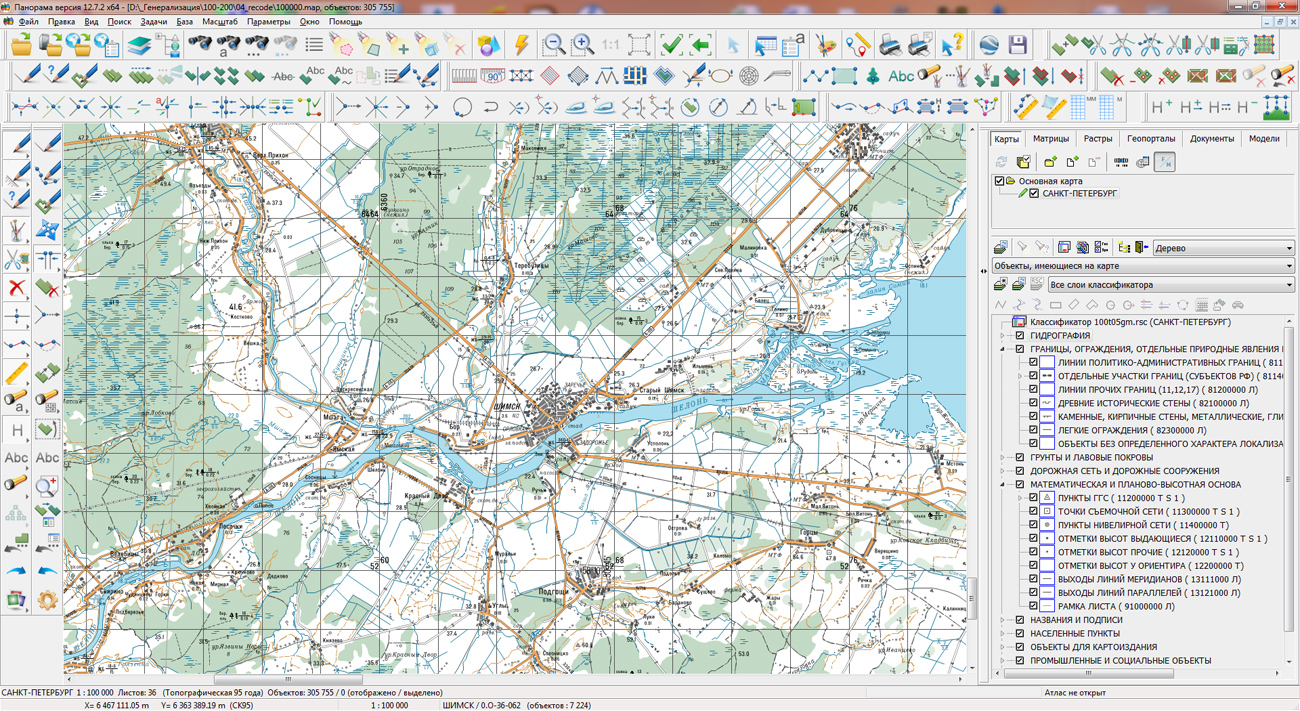
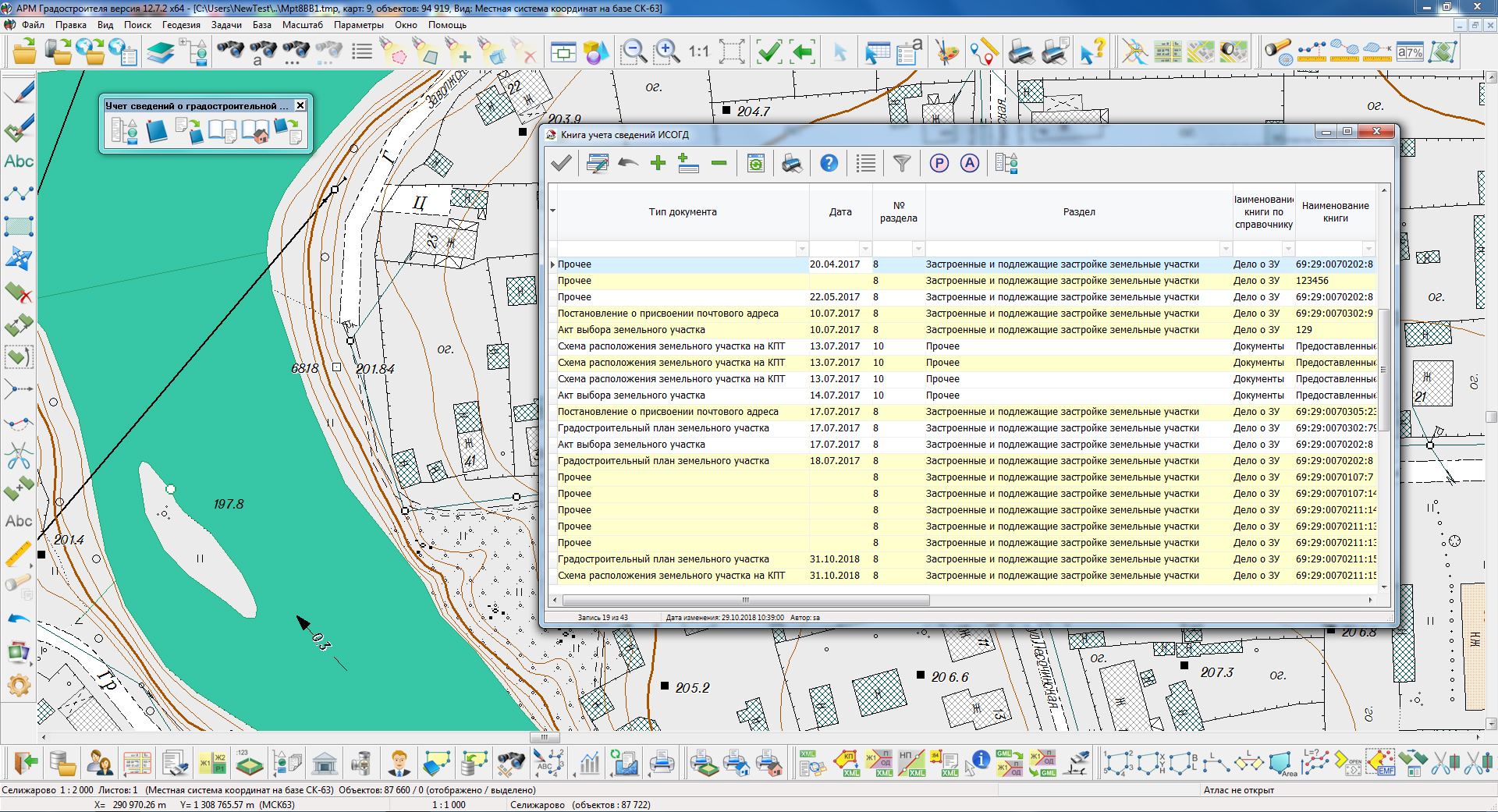
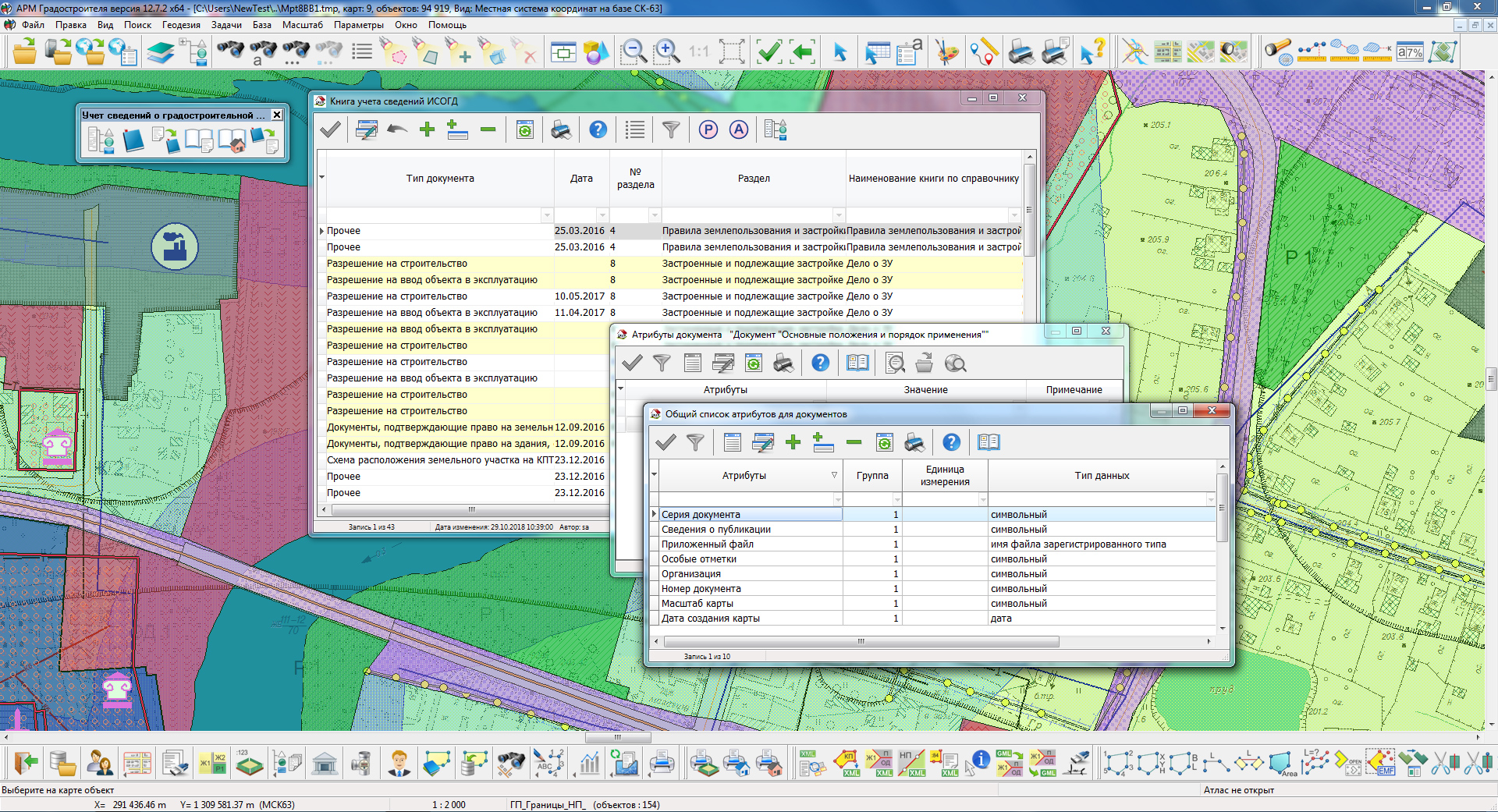
In KB "Panorama" the version 12.7.2 is developed. The new version of the program is supplemented with functions of stream loading the documents for urban planning activities using the address. When preparing various permits, the address, for example, Sovetskaya 34, is most often used as the file name of the document. When automating the process of streaming the documents, this feature of document preparation is used. The program reads data from the folder corresponding to the type of urban-planning document, for example, "Building permit", and generates an address line by file name. To obtain the full address, the value specified by the operator from the directory of the administrative-territorial unit is used. In the process of loading, an account is created in the "Documents" registry in accordance with the type of the document and direct address geocoding is carried out. For geocoding, various sources can be used: the current address database from the "Workstation of urban-planner", the address database located on the website of KB "Panorama" and the address databases from open sources.
In the "Documents" registry, the list and content of directories has been expanded and service modes have been added to ensure the group assignment of the same attribute values to different documents. When stream addition of records about the document into the registry, the value of attributes the "urban-planning document type" and "document code" are automatically filled, according to the specified values.


In KB "Panorama" the version 4.7 is developed. In the new version of the program the tools for working with virtual folders of service the are expanded. Virtual folder is a means of accessing to the map layers at the data folders level. Data layers from them are published automatically and can be added into the map. The new version allows you to use folders located on various services. The ability to control the saving of map objects and subsequent operations on the object has been added into the map editor. There are updated a search of objects in the map according to the semantics of the type "Date" and the operation of the map in 3D mode when displaying three-dimensional symbols using the classifier. Subsystem of authorisation and the module of administration of application's users are updated.
The toolkit of developing the Web-applications the GIS WebToolKit SE has been improved, which expands possibilities of GIS WebServer SE and can be integrated into other information systems. Access to data (images, vector maps and terrain information) is provided by Web services using common OGC protocols and ISO standards. Service of GIS WebService SE (OGC WMS/WMTS) provides spatial information in the form of graphic images. Various types of high-altitude data are used as a digital elevation model: matrixes (in the formats SRTM, GeoTIFF, IMG, MTW), TIN-models, point cloud and others. At request the most accurate data onto a specified terrain site with a given resolution is automatically sampled. To transfer data of the digital terrain model to the Web, the WCS protocol is used. The relief data is represented as tiles and cached on the client.
As a source of spatial data, the can be. It provides the collection, storage, search and delivery of spatial data in exchange formats, a displaying the state of the data bank in the form of maps-schemes, the automated formation and updating of geo-covers.
GIS WebServer SE is used in the construction of closed corporate systems to ensure the protection of data having a security classification or a trade secret. GIS WebServer SE is certified for Level 2 of absence of undeclared capabilities. The new version of the program expands the application's capabilities in solving problems of analysis, management and long-term planning of the territories development. GIS WebServer SE is implemented using the toolkit of GIS WebToolKit SE, which can be used in development tools that use the JavaScript.
The new version of the program is available on the website in the section.


Ph.: +7 (495) 739-0245, +7 (925) 221-1603
www.gisinfo.ru | panorama@gisinfo.ru
105005, Russia, Moscow, Baumanskaya Street 7, building 1, office 229 (m. Baumanskaya)
Copyright © Panorama Group 1991 - 2024


 Mobile version
 Full version