Copyright © Panorama Group 1991 - 2024

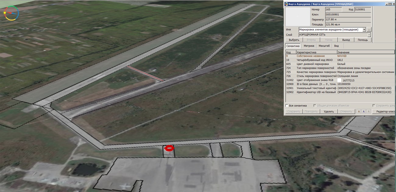
In KB "Panorama" the version 7.1 for the x64 is developed. The new version adds a dialog for maintaining a database of markings of artificial airfield pavements and ground elements of the aerodrome. The interface of input and output of obstacles is improved. There are implemented the possibility of group operations with obstacles, calculation of relative height when applying, import of individual attributes from MS Excel. The built-in converter ARINC added the ability to load obstacles in the ARNAD format. The functions of the AIXM converter have been expanded when importing the aerodrome infrastructure elements and ground zones of various types. Aeronautical classifier is improved.
Complex of preparing documents of the aeronautical information is intended for the creation and maintenance of a database of aeronautical information, the formation of aeronautical charts, the designing of flight routes for aircraft and the exchange of data with other information systems. Information exchange is carried out in ARINC and AIXM 5.1 formats. The main source of aeronautical information is the aeronautical data base created on the basis of the Aeronautical Information Conceptual Model (AICM), with additions for storing the planned information and the results of the route designing. The model is recommended by the international organization for planning and coordination of air traffic "Eurocontrol".
The new version of the program, examples of documents of aeronautical information, the operational documentation, video lessons and presentations are available for download on the page.


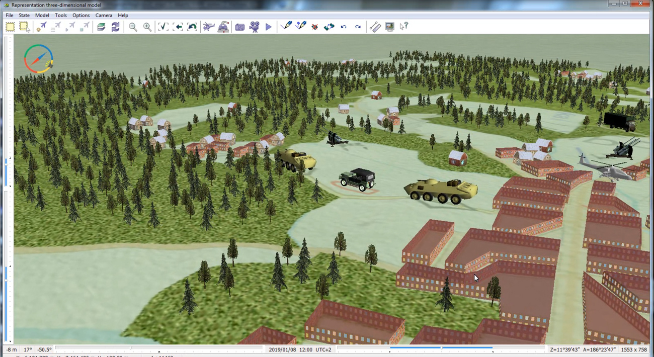
In KB "Panorama" the version 12.7 is developed for the x64 platform. In the new version in the "Navigator 3D" task, support has been added for displaying data in a volumetric form from geoportals for monitoring vehicle movement, weather changes or other dynamic phenomena. Data acquisition is performed by connecting web-services using the WFS protocol. In this case, you can find out the current information about a moving object: exact coordinates, current speed, height (depth) of movement, workload, remaining amount of fuel and other data that an object can give about itself. All this is placed into its metric and semantic characteristics and is given to the operator in a dialog when selecting the object of interest. The period of updating information depends on the frequency with which the object displays information, and on the settings of the Update period specified in the Options menu. For example, from the Flightradar24 geoportal, you can track the position of an aircraft if it is equipped with an ADS-B type transponder, which every second generates and broadcasts a radio message that contains exact coordinates, speed, altitude and other information about the aircraft. The service uses ADS-B receivers installed all over the world, which receive information from airplanes and send it to the Flightradar24 server. There are improved the tools of importing models of formats Collada, TLS, OC3 to the database of three-dimensional DB3D tiles in the mode of adding and updating models in the database.
The task "To locate photos of JPEG on map by GPS-coordinates", designed to automatically link JPEG photos to the map, has been improved. The list of formats of processed source data in the "preliminary compilation" mode has been expanded. Loading the project of data of shooting from the UAV is added. The project of shooting's data is a set of JPEG files plus a text file — a list of JPEG photos and GPS-coordinates of points of photographing that correspond to them. The "preliminary compilation" mode allows you to process shooting materials obtained from the UAV. An automatic binding and turn of the photo image by coordinates of the shooting point and the direction angle of the image is carried out.
Possibility of obtaining and displaying the packed pyramids of tiles from the is added. Data can be in BIR, Mbtiles formats, stored in a database managed by SQLite DBMS. Pyramids of tiles can be created in the program, including in the environment of the , using vector maps, remote sensing data and matrixes of heights of relief and terrain objects. Access to tiles pyramids can be offline without the use of server applications, as well as in client-server mode through via the OGC WMTS protocol or through the GIS Server version 8.3 and higher. When accessing client-server mode, the tiles that were accessed are automatically cached on the client's computer, similar to working through a web browser.
Import of a set of files of format S57 (000, 030, 031) from the folder containing the subfolders with the sea map files is implemented. The processing of the S57 format has been accelerated in several times due to the multi-threaded processing of data sets on multi-core processors. The output map can be created in the MAP format (multi-sheet map) or as a set of maps of the formats SIT, SITX as part of the MPT project.
Ability is added for calculating the absolute height at a given point, taking into account the data of nautical charts of IHO S57/S52 standards. When calculating the height, the data of isobaths, depth marks, coastlines and height-level objects are used. There are used the values of semantic characteristics the "Isobath value", "Height above sea level", and also the values from 3D metrics of depth marks. The function of calculating the absolute height according to data of the vector map is used in the "Map Computer" task, as well as in the Complex of hydrological tasks and the Complex of 3D analysis.
Into dialog of search and mark of map objects into the "Measurement" bookmark the possibility is added to set a condition of selecting objects by number of points in the main contour of object. For example, if you need to mark polygons having the shape of a rectangle (4 corners), you can search for a metric of 5 points (the first and the last are the same).
The task of connecting geoportals is improved. Ability is added for displaying geoportals beyond 180 and -180 degrees in longitude for all supported standards. It allows you to display more visually the data on territory of Chukotski Peninsula and Alaska, and also to carry out editing of objects in these territories. Setting sizes of displaying is done via the "Configure geoportals" menu item. By default, the display area of geoportals is set from -225 to 225 degrees.
A call of the "Transparent color" mode has been added to the "Data list" dialog. The mode is designed to disable the display of both one and a group of colors from a palette of 16, 256-color rasters. For 24 bit rasters, a disabling of displaying one color is carried out. The new mode is called on the "Rasters" bookmark by the item of the contextual menu "Transparent color".
In the dialogs of recalculating and displaying the coordinates of the current point on the map, the replacement of the coordinate system PZ-90.02 by PZ-90.11 is performed.
The new version of the program is available for download in the section.


Specialists of KB "Panorama" prepared a video lesson . It is intended for the English-speaking users who independently study the possibilities of . In this lesson the work with three-dimensional objects is considered. From it you will learn how to create a 3D-object, edit its properties and place on the map.
The video lesson shows a phased adjustment of the three-dimensional view of an object using the "Classifier Editor" panel. To create a new or edit an existing object, use the "Templates" bookmark. After saving all the settings, the creation of a three-dimensional model is demonstrated. The operation is started using the corresponding button on the main program panel. Moving around and controlling a 3D object is done with the mouse.
Previously other video tutorials of this series were published: , "Operations on points", "Map classifier". Earlier other video lessons of this series have been published: "Object creation tools", , "".
You can get acquainted with the educational materials in English in the section .


In KB "Panorama" the program version 8.4 is developed. The new version improves the reliability of working with large lists of maps, rasters and matrixes when they are intensively processed by various services and user groups. Algorithm for sorting maps on the server is clarified. Algorithm for monitoring server status from desktop applications is improved. Diagnostic printing is expanded.
Ability is added for publishing the packed pyramids of tiles in BIR, MBTILES formats based on a SQLite database. Pyramids of tiles can be created in the program, including in the environment of the , using vector maps, remote sensing data and matrixes of heights of relief and the terrain objects. When publishing tiles, on the client’s computer those tiles that were accessed are automatically cached, similar to working through a web browser. Viewing the pyramids of tiles from the server is supported in the version 12.7 and higher. At connecting the databases there is added a processing of parameters of the user coordinate systems by extended codes from the crslist.xml file.
GIS Server is designed to provide remote access to spatial data for users of programs GIS "Panorama", , and others. The software product is certified in the information security system. GIS Server is used in various federal, regional and corporate projects for managing spatial databases, for organizing the interaction between web clients, desktop and mobile clients and various service departments.
The new version of the program is available for download on the page.


In KB "Panorama" the is developed for the x64 platform. In the new version in the "Navigator 3D" task, support has been added for displaying data in a volumetric form from geoportals for monitoring vehicle movement, weather changes or other dynamic phenomena. Data acquisition is performed by connecting web-services using the WFS protocol. In this case, you can find out the current information about a moving object: exact coordinates, current speed, height (depth) of movement, workload, remaining amount of fuel and other data that an object can give about itself. All this is placed into its metric and semantic characteristics and is given to the operator in a dialog when selecting the object of interest. The period of updating information depends on the frequency with which the object displays information, and on the settings of the Update period specified in the Options menu. For example, from the Flightradar24 geoportal, you can track the position of an aircraft if it is equipped with an ADS-B type transponder, which every second generates and broadcasts a radio message that contains exact coordinates, speed, altitude and other information about the aircraft. The service uses ADS-B receivers installed all over the world, which receive information from airplanes and send it to the Flightradar24 server. There are improved the tools of importing models of formats Collada, TLS, OC3 to the database of three-dimensional tiles tiles DB3D in the mode of adding and updating models in the database.
Possibility of obtaining and displaying the packed pyramids of tiles from the is added. Data can be in BIR, Mbtiles formats, stored in a database managed by SQLite DBMS. Pyramids of tiles can be created in the program, including in the environment of the , using vector maps, remote sensing data and matrixes of heights of relief and terrain objects. Access to tiles pyramids can be offline without the use of server applications, as well as in client-server mode through via the OGC WMTS protocol or through the GIS Server version 8.3 and higher. When accessing client-server mode, the tiles that were accessed are automatically cached on the client's computer, similar to working through a web browser.
Import of a set of files of format S57 (000, 030, 031) from the folder containing the subfolders with the sea map files is implemented. The processing of the S57 format has been accelerated in several times due to the multi-threaded processing of data sets on multi-core processors. The output map can be created in the MAP format (multi-sheet map) or as a set of maps of the formats SIT, SITX as part of the MPT project.
Ability is added for calculating the absolute height at a given point, taking into account the data of nautical charts of IHO S57/S52 standards. When calculating the height, the data of isobaths, depth marks, coastlines and height-level objects are used. There are used the values of semantic characteristics the ISOBATH VALUE, HEIGHT ABOVE SEA LEVEL, and also the values from 3D metrics of depth marks. The function of calculating the absolute height according to data of the vector map is used in the "Map Computer" task, as well as in the Complex of hydrological tasks and the Complex of 3D analysis.
In dialog of search and mark of map objects into the Measurement bookmark the possibility is added to set a condition of selecting objects by number of points in the main contour of object. For example, if you need to mark polygons having the shape of a rectangle (4 corners), you can search for a metric of 5 points (the first and the last are the same).
The task of connecting geoportals is improved. Ability is added for displaying geoportals beyond 180 and -180 degrees in longitude for all supported standards. It allows you to display more visually the data on territory of Chukotski Peninsula and Alaska, and also to carry out editing of objects in these territories. Setting sizes of displaying is done via the Configure geoportals menu item. By default, the display area of geoportals is set from -225 to 225 degrees.
The task "Isolines generalization", which is a part of the "Automated generalization of topographical maps" software, and intended for transforming the relief of map of the original scale into a map of a smaller (derived) scale, has been improved. In order to reduce the losses of the relief's shape, the processing of closed contours of a small area has been added. Previously, such isolines were removed, now closely spaced small isolines are merged together, and then the result of the merging is checked by the area threshold.
The list of tasks for automated processing of vector maps is expanded in the task "Processing of map by scenario". A new task "Correction of object metrics" has been developed. The task removes outliers and double points at the specified tolerance; removal of initial and final coinciding segments of linear objects; cutting the contours of linear objects at points of junction; cutting the contours of polygon objects at the points of junction and self-intersection; conversion of multi-lines into simple lines; conversion of multipolygons into simple polygon objects with internal sub-objects.
The task "To locate photos of JPEG on map by GPS-coordinates" is improved. Loading the project of data of shooting from the UAV in the "preliminary compilation" is added.
The project of shooting's data is a list of JPEG photos and GPS-coordinates of points of photographing that correspond to them. The "preliminary compilation" mode carries out an automatic binding and turn of the photo image by coordinates of the shooting point and the direction angle of the image.
A call of the "Transparent color" mode has been added to the "Data list" dialog. The mode is designed to disable the display of both one and a group of colors from a palette of 16, 256-color rasters. For 24 bit rasters, a disabling of displaying one color is carried out.
In the dialogs of recalculating and displaying the coordinates of the current point on the map, the replacement of the coordinate system PZ-90.02 by PZ-90.11 is performed.
The new version of the program is available for download in the section.


Ph.: +7 (495) 739-0245, +7 (925) 221-1603
www.gisinfo.ru | panorama@gisinfo.ru
105005, Russia, Moscow, Baumanskaya Street 7, building 1, office 229 (m. Baumanskaya)
Copyright © Panorama Group 1991 - 2024


 Mobile version
 Full version