Copyright © Panorama Group 1991 - 2024

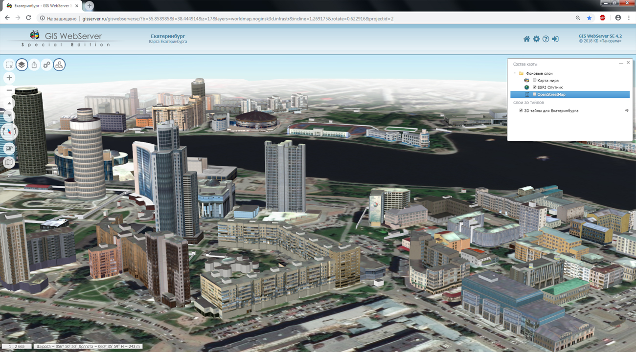
In KB "Panorama" the version 4.3 is developed. In the new version the ability to connect the user's controls is added. User's controls are modules developed in PHP and JavaScript and used in GIS WebServer SE to expand its capabilities. Connection and development of modules is carried out through API interface the GIS WebServer SE. Like the standard components of the map, the modules are included in the maps projects and are used in the work. The program optimized the display of a cloud of points and line primitives in tile models. The positioning the model of 3D tiles is carried out taking into account height of a point of a tile binding. To speed up the display of the three-dimensional model, caching of auxiliary tiles has been added. In the "Map Editor" a mode for editing the metric part has been developed. Parameters of editing the metric are expanded: there are added a capture of points and capture of lines (a point on a line within capture radius).
In a map the ability to set its maximum dimensions is realised. The operations of moving the map, searching and selecting objects are performed within the established dimensions of the map. Into local layers of a map the display of titles for point objects is added. The text of the title can be output from the local layer classifier file, the geojson file, or set by default parameters. Loading the classifiers of map layers is optimized. The interface of the map user is updated. In the administration module the registration and setting up rights onto user's controls is added.
The toolkit of developing the Web-applications the GIS WebToolKit SE has been improved, which expands possibilities of GIS WebServer SE and can be integrated into other information systems. Access to data (images, vector maps and terrain information) is provided by Web services using common OGC protocols and ISO standards. Service of GIS WebService SE (OGC WMS/WMTS) provides spatial information in the form of graphic images. Various types of high-altitude data are used as a digital elevation model: matrixes (in the formats SRTM, GeoTIFF, IMG, MTW), TIN-models, point cloud and others. At request the most accurate data onto a specified terrain site with a given resolution is automatically sampled. To transfer data of the digital terrain model to the Web, the WCS protocol is used. The relief data is represented as tiles and cached on the client.
As a source of spatial data, the can be. It provides the collection, storage, search and delivery of spatial data in exchange formats, a displaying the state of the data bank in the form of maps-schemes, the automated formation and updating of geo-covers.
GIS WebServer SE is used in the construction of closed corporate systems to ensure the protection of data having a security classification or a trade secret. GIS WebServer SE is certified for Level 2 of absence of undeclared capabilities. The new version of the program expands the application's capabilities in solving problems of analysis, management and long-term planning of the territories development. GIS WebServer SE is implemented using the toolkit of GIS WebToolKit SE, which can be used in development tools that use the JavaScript.
The new version of the program is available on the website in the section.


In KB "Panorama" the version 8.2 is developed. The new version adds support for displaying and editing vector maps hosted on a server that are larger than 4 GB.
Into parameters of creating backup copies of data sets the period of storage of backup copies in months was added. When updating a dataset and forming a regular copy, it checks and deletes copies created by a specified number of months earlier. If in the current year fewer months have passed than specified in the settings (for example, 5 and 6), then folders will be deleted starting from the year before last and earlier, that is, by year. Support of the software license for program work (without a USB dongle) is added.
The tools for loading data sets into the have been improved. The new version allows you to handle special characters (quotes and others) in the metadata added into the dslist data list. Ability is added for loading into the database of marine navigational charts of S57 standard, packaged in ZIP format. The composition of diagnostic messages when updating vector maps is clarified. The formation of two types of protocols (extended and short) are implemented when loading the data sets. Advanced tools of event logging increase the reliability and fault tolerance of the application, speed up the search for errors and decision-making by the administrator for changing the server's hardware. In the new version the tools of remote administration of working the Server GIS in web are expanded.
Ability is added for deleting a directory with files inside a virtual folder by the command of a client. The sorting of the vector representation of the spatial database has been implemented to speed up the display operations after multiple updates.
For supporting a single distributed geographic information space, the GIS Server provides multi-user access to spatial data for application servers () and desktop clients (, and others). The server performs the change of the geospatial data bases by the requests generated through the graphic interface of the GIS "Panorama", by means of editing digital maps of the terrain. Multilevel connection of servers among themselves is supported for the distributed storage and processing of spatial data with automatic replication, backup and data protection.
The new version of the program is available for download on the page.


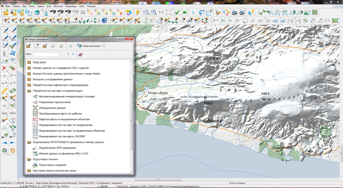
KB "Panorama" prepared a digital geographical map of scale 1: 1 000 000 in format SXF onto the territory of the state of Iceland. obtained according to information from the website has served as source for map's preparation.
The map contains information about the quantity of inhabitants for cities and the names of settlements in Russian. As additional materials the World map of scale 1: 5 000 000 and data of were used. The map is led to the classifier of geographical maps of scale 1: 1 000 000 (1mogk13g.rsc). It can be used for the general estimation of the terrain and studying of an environment, an ensuring of educational process, as a basis for creation of geographical maps of smaller scale, thematic and special maps and solving other tasks.
The map is distributed free according to the free . Digital geographical map of scale 1: 1 000 000 in format SXF is available for downloading on page the "Digital maps and images".


In KB "Panorama" the version 8.3 is developed. In the new version, the service provides preparation and synchronization of pyramids of tiles with spatial data bases in near-real-time mode. For example, to update a spatial database containing about 10 million objects in 12 layers, the speed of formation of a fragment of tiles on a screen in Full HD format at a base scale of 1: 10 000 on an average is 50 ms. Acceleration is achieved through the internal architecture of the service. Using the architecture of distributed and parallel computing can significantly simplify the process and technology of user interaction with large amounts of data, reduce the hardware requirements necessary for the functioning of the server.
In the new version of the program the mode for removing tiles is added. It allows you to delete tiles for certain territories, scales and matrixes, specified in the program settings. Support for PHP version 7 and higher is added.
Service provides updating of pyramids of tiles in formats PNG, PNG8 and JPEG. It allows you to maintain tiles up-to-date on the data hosted on the . Pyramids of tiles are published according to the OGC WMTS protocol by service the . GIS that support the OGC WMTS protocol and users of the program can be the clients of the service.
The new version of the program is available on the website in the section.


In KB "Panorama" the version 12.6.2 for the x64 platform is developed. In the new version in the task "Navigator 3D", the list of formats of imported models is expanded for displaying exact and realistic three-dimensional models of infinitely large size in DB3D format. There is added a support for importing three-dimensional models from the Collada format to 3D-tiles of spatial data. COLLADA format is the international standard for an exchange of three-dimensional data. Models in this format can be obtained using such programs, as: , Maya, 3ds Max, MeshLab, CityScape, CityEngine, SketchUp, Blender, Poser (v.7.0), Lightwave 3D (version 9.5), Cinema 4D (MAXON), Softimage XSI, Houdini, modo and Strata 3D, Adobe Photoshop from version CS3 and others. The models loaded into the DB3D format can be used to build a three-dimensional model of the terrain together with other data sources: vector maps, space and aerial photographs, geoportals, point clouds, matrixes of elevations.
The support is added for new data formats MAPZ and SITZ. The multisheet map and the user map can be packed into one file with compression of data by ZIP-Deflate algorithm. Conversion to SITZ and MAPZ format is performed in the task "Map Sorting". To increase the degree of compression, the accuracy of the object metric is automatically converted to centimeters. Unpacking of data is carried out automatically in memory in process of reading the corresponding sheets and objects from the packed formats. The packed maps are accessible read-only. Reducing the amount of data allows you to speed up their transmission over communication channels.
In the main menu of the program in section "File - Import rasters or matrix from...", the menu item "Matrix GDAL" is added. The item is intended for execution of importing the matrixes of elevations and qualities from files of formats GeoTiff, IMG, DEM. Reading source files at import is performed by means of GDAL library. In the task "Import of GPS-coordinates in format NMEA 0183", there is added the processing of RMC message at import of GPS-coordinates using the NMEA 0183 protocol. The RMC message transmits the recommended minimum of navigation data - device position, velocity, time of positioning.
The task "Lists of objects" is refined. Into search by lists the option "Crossing and outside" is added. At search or mark of objects with the enabled option "Crossing and outside", the objects will be found that are crossed or are located outside relative to objects of another list. There are expanded the possibilities of finding and marking the map objects by semantics in the "Search and mark" dialog. The list of semantics values and searching conditions can be grouped with specifying of logic conditions within groups and between groups - ALL ARE TRUE (AND) or AT LIST ONE IS TRUE (OR), that allows to create in an interactive mode the complex conditions of search for objects by value of their attributes.
"Map Editor" task is improved. The new mode of creating a multipolygon by selected polygon objects is added.
The set of complex views of conventional symbols for displaying lines with variable length of dashes has been expanded. New conventional symbols are applicable, for example, to display linear river beds and other linear objects with varying line width. Samples of symbols of a new view have been added into maps Shape\shape.sitx: File - Example data.
The new version of the program is available for download in the section.


Ph.: +7 (495) 739-0245, +7 (925) 221-1603
www.gisinfo.ru | panorama@gisinfo.ru
105005, Russia, Moscow, Baumanskaya Street 7, building 1, office 229 (m. Baumanskaya)
Copyright © Panorama Group 1991 - 2024


 Mobile version
 Full version