Copyright © Panorama Group 1991 - 2024

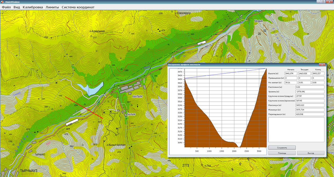
In KB "Panorama" the GIS Constructor version 12.3.2 the GIS is developed for operating system MSVS 3.0. The new version adds the ability to build a surface profile along a specified line or selected object using a matrix of heights. The result is displayed in a window as a graph, with help of which the user can interactively determine the elevation parameters at the selected point (profile height, degree of slope). Automatically calculates the elevation's values of current and end points that must be added to ensure line of sight. The building results can be exported to a text or graphic file (bmp, png, jpeg). Import of high-altitude data from the exchange format grd is realized.
The visual component of animation of objects of a vector map is added. It allows you graphically to select an arbitrary set of objects with a given color and periodicity. With this functionality, you can implement an animated representation of the result of a search or the operations of adding, deleting, editing objects. Selection of objects for marking is carried out using standard tools of work with the context of the search from the MAPAPI interface. The animation component can be used in combination with the Qt framework's drawing tools to implement arbitrary dynamic selection of spatial data.
The set of test examples is expanded, including: creating of a matrix of qualities, constructions of a visibility area, import of the height data from the grd format, a changing the coordinates of the metrics of object. The functionality of the basic demonstration example mapview is supplemented by map turn, change of parameters of displaying the spatial data (brightness, contrast, transparency), moving of window to the point and center of the object, displaying the cursor coordinates in the status bar.
In the print component, the functionality of outputting spatial data to a physical printer is realized. There is increased the maximum number of processed search contexts for processing vector maps with a large number of sheets in the search component. The processing of the classifier in the component of the road graph is improved.
GIS Constructor is a set of geoinformation components for use in the visual programming environment of Qt Designer, which allows you to develop your own GIS applications. The visualization of the contents of digital maps is made in conventional symbols adopted for topographic, geographical and various special maps. Geoinformation system has ample opportunities for performing calculations, for providing display of spatial data on various graphic devices in standard and user systems of conventional symbols. The main functions can be executed in multithreaded mode. It supports automatic optimization of used memory for processing large amounts of data (tens of gigabytes) on limited resources (hundreds of megabytes).
The toolkit is adapted to work on a wide range of platforms and supports operating systems such as Astra Linux SE, MSVS, CRTOS Neutrino, Elbrus, Zarya, Ubuntu, Alt Linux, QNX, CentOS and others. It can be used in computer complexes with processors of architectures ARMv7, Elbrus, PowerPC, Intel x86, Intel x64 and others.
The new version of the program is available for download in the section.


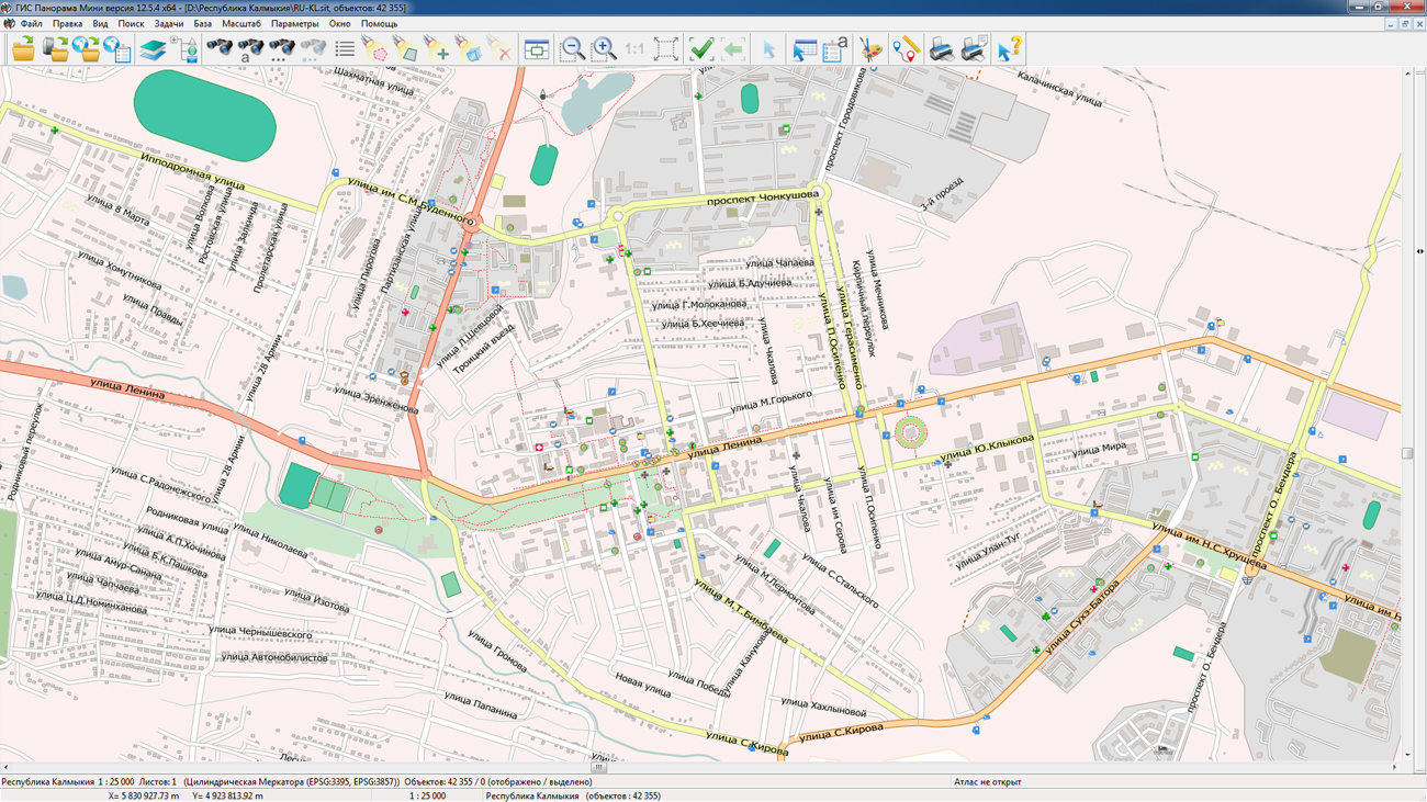
On the geoportal , the maps of the Kalmykia and Adygea, formed according to OpenStreetMap data, were updated. Source data obtained from the GIS-Lab website are complemented by objects from maps of scale 1: 1 000 000. There are added the objects of hydrography, vegetation, road network. For work with the received maps it is possible to use the program of or other software products of KB "Panorama".
Publishing of updates in bank of spatial data is made by using the program of. Publishing contents of bank of spatial data on the geoportal and data access for downloading are implemented by means of GIS WebServer SE.
Free maps on the basis of OpenStreetMap data are available for download on the page "Digital maps and images".


In KB "Panorama" the version 11.13.11 is developed for operating system Astra Linux Special Edition (Release "Smolensk"). In the new version the mode of drawing objects onto vector maps is improved. Geodetic coordinates of objects can be specified in radians, degrees or in degrees, minutes and seconds. By means of the advanced "Map contents" dialog, the user for each map individually sets the visibility, the ability to edit and select an object. This allows at the displaying to focus on individual maps and excludes the possibility of their random editing.
The mechanism for saving user's session settings has been improved. Now the parameters file is written not into the temporary directory of the system, but into the user's home directory. This allows you to save the settings after rebooting the system and to differentiate the sessions of the individual users. The convenience of working with the dialogs "Map print", "Label options", "Matrix builder" has been improved. In the dialog "Create object" the checking of entering an incorrect metric is extended. Displaying objects of operational situation in accordance with the CEUZ is refined.
GIS "Operator" is an universal domestic geoinformation system for power structures. The program is intended for accumulation, the storage, the automated processing and displaying the data, results of calculations and the forecasts having a geospatial binding. GIS "Operator" contains tools for displaying and processing vector, raster and matrix maps. The application provides users with tools for solving specialized tasks of modeling the movement of special objects against the background of 3D model, a forecasting the consequences of emergencies on hazardous objects, a monitoring the movement of aircraft, a performing the geodetic and topographic work, processing data from GPS/GLONASS navigation devices, a printing the displayed spatial data to various output devices and many others. GIS "Operator" SE is certified by the 2nd level of control of the absence of undeclared capabilities in the RF Ministry of Defense.
The new version of the program is available for download in the section.


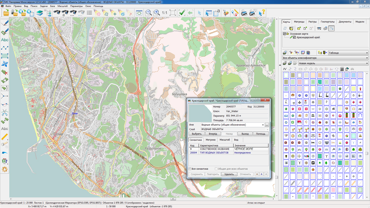
On the geoportal , the map of Krasnodar territory, formed according to OpenStreetMap data, was updated. Source data obtained from the website are complemented by objects from maps of scale 1: 1 000 000. There are added the objects of hydrography, vegetation, road network. For work with the received maps it is possible to use the program of or other software products of KB "Panorama".
Publishing of updates in bank of spatial data is made by using the program of . Publishing contents of bank of spatial data on the geoportal and data access for downloading are implemented by means of GIS WebServer SE.
Free maps on the basis of OpenStreetMap data are available for download on the page "Digital maps and images".


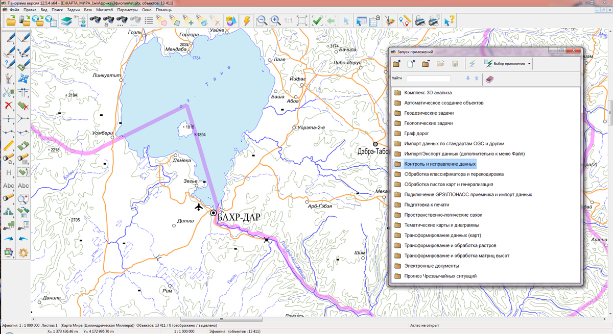
KB "Panorama" prepared a digital geographical map of scale 1: 1 000 000 in format SXF for the Federal Democratic Republic of Ethiopia. obtained according to information from the website has served as source for map's preparation.
The map contains information about the quantity of inhabitants for cities and the names of settlements in Russian. As additional materials the World Map of scale 1: 5 000 000 and data of were used. The map is led to the classifier of geographical maps of scale from 1: 1 000 000 (1mogk13g.rsc). It can be used for the general estimation of the terrain and studying of an environment, an ensuring of educational process, as a basis for creation of geographical maps of smaller scale, thematic and special maps and solving other tasks.
The map is distributed free according to the free . Digital geographical map of scale 1: 1 000 000 in format SXF is available for downloading on page "Digital maps and images".


Ph.: +7 (495) 739-0245, +7 (925) 221-1603
www.gisinfo.ru | panorama@gisinfo.ru
105005, Russia, Moscow, Baumanskaya Street 7, building 1, office 229 (m. Baumanskaya)
Copyright © Panorama Group 1991 - 2024


 Mobile version
 Full version