Copyright © Panorama Group 1991 - 2024

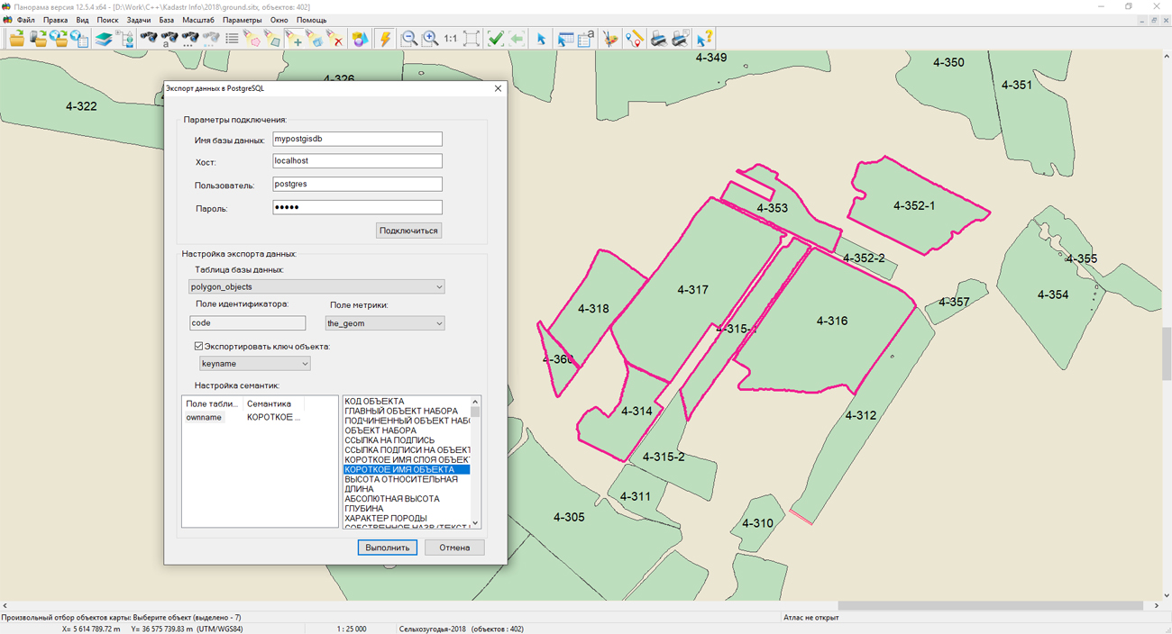
On the website of KB "Panorama" the fourth lesson of the series "Development of applications for GIS "Panorama" was published. In this lesson we explain the mechanism for implementing stream tasks on the example of creating a mode of exporting map data into PostgreSQL database.
From the training materials, you can learn about the features of spatial data storage in PostgreSQL databases and how to access them from your own applications. The lesson includes the source code of task for exporting vector map objects into PostgreSQL and the ready-made mode library. This material will help to understand not only the mechanism for creating stream tasks for the , but also the general aspects of creating any of your own applications that work with the PostgreSQL DBMS.
The cycle of lessons "Development of applied tasks for GIS" Panorama is available for acquaintance in the "Video lessons" section.


In KB "Panorama" the version 9.4 is developed for OS Astra Linux SE (Release "Smolensk"). The program forms pyramids of tiles in the formats JPEG, PNG, PNG8 and Mbtiles according to the international standard OGC WMTS 07-057r7 version 1.0.0 and the TMS standard. Imagery Creator allows you to process the cartographical data both on territory of the whole Globe, and on individual continents and countries. For example, for forming 700 000 000 tiles on 84 maps onto territory of Russia at the scale of 1: 10 000, containing 19 000 000 objects, the Imagery Creator program needed 9 hours.
Imagery Creator provides remote administration of data via the web interface. The program allows you to connect to data on the and create backup copies of the generated data. It creates tiles for the object, taking into account or without taking into account the contour of the object, it forms tiles of small scale according to tiles of a larger scale. With its help it is possible to choose pyramids of created tiles: GoogleMapsCompatible, EPSG:3395, TMS, MILLER and others. The application provides remote monitoring the status of work, the percentage of the current task's execution, the forecasting of the completion time. Imagery Creator logs its actions, allows you to adjust the performance by monitoring the number of threads of cutting and the amount of RAM consumed.
The tile data generated by the Imagery Creator are used by software the , to provide high-speed query execution for displaying spatial data over large areas while simultaneously accessing a large number of users.
A new version of the program is available on the page.


On the geoportal the maps of the Sverdlovsk and Chelyabinsk oblasts formed according to OpenStreetMap data, were updated. Source data obtained from the website are complemented by objects from maps of scale 1: 1 000 000. There are added the objects of hydrography, vegetation, road network. For work with the received maps it is possible to use the program of or other software products of KB "Panorama".
Publishing of updates in bank of spatial data is made by using the program of . Publishing contents of bank of spatial data on the geoportal and data access for downloading are implemented by means of GIS WebServer SE.
Free maps on the basis of OpenStreetMap data are available for download on the page "Digital maps and images".


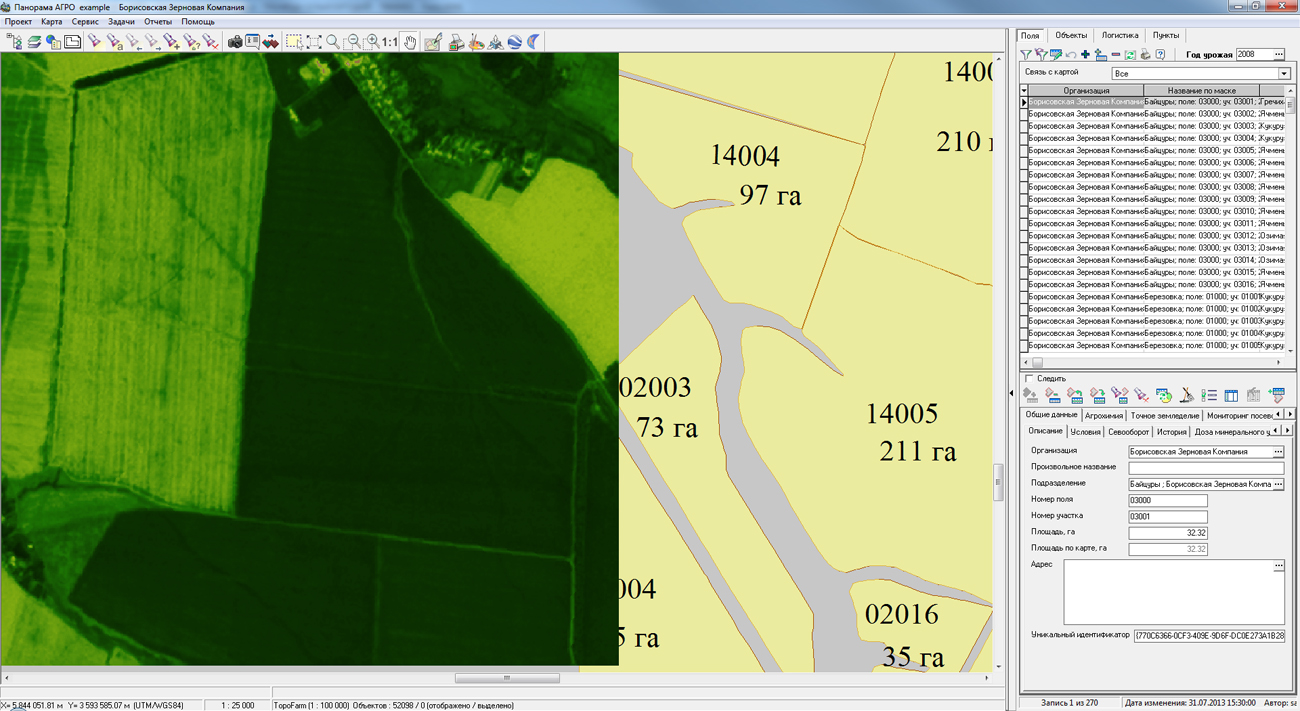
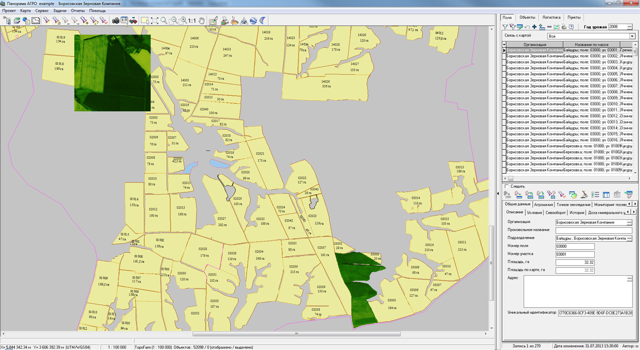
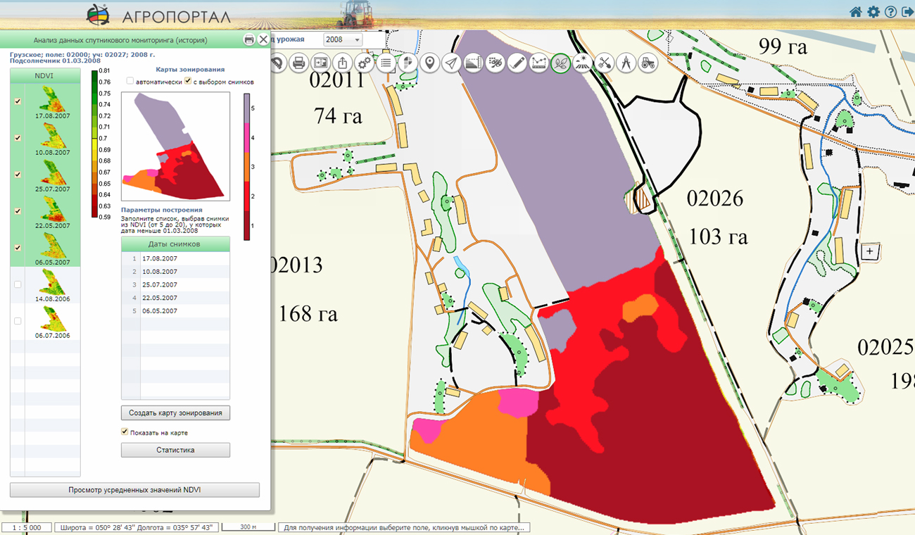
In KB "Panorama" the version 5.0 is developed, which supports viewing the matrixes of vegetation indices obtained as a result of satellite monitoring.
Numerical values of vegetation indexes are calculated by external service of satellite monitoring. The result is provided in the form of a matrix of qualities with a discreteness corresponding to the resolution of the original image. Data of satellite monitoring are provided by the Geosys company.
The new version of "Panorama AGRO" supports a viewing and analysis of the matrixes of vegetation indices of the following types: Normalized Difference Vegetation Index (NDVI), Chlorophyll Vegetation Index (CVI), Enhanced Vegetation Index (EVI), Green Normalized Difference Vegetation Index (GNDVI). The most popular in agriculture is the index NDVI (Normalized Difference Vegetation Index) - the normalized relative index of vegetation, according to which it is possible to judge the development of plant biomass during vegetation. According to numerous scientific publications, according to the NDVI index, crop yields can be predicted with high accuracy. The vegetation index NDVI is changed all season and its values are different during the growth, flowering and maturation of plants.
GIS "Panorama AGRO" allows to use full range of data required for technologies of exact agriculture: data of satellite monitoring the crops, soil sampling points, maps of soil fertility, application of GLONASS/GPS tools for monitoring the field progress and yield mapping, preparation for the differentiated application of fertilizers, support of data collection from unmanned aerial vehicles, monitoring of vehicles and agricultural machinery, and others.
Line of agricultural geoinformation products of KB "Panorama" for desktop and WEB clients includes the "Panorama AGRO", , , "Workstation of Agronomist", Panorama AGRO Service and .
Constructed on their base the corporate GIS in a combination with cartographical and professional provides a single geoinformation space for the agro-enterprise.
New versions of the programs are located on our website in the section.


In KB "Panorama" the version 2.5 is developed, in which possibility for the visual analyzing the data of satellite monitoring of agricultural land is added. The new version of the program allows you to view the data of vegetative indices NDVI (Normalized Difference Vegetation Index) and GNDVI (Green Normalized Difference Vegetation Index), characterizing the development of plant biomass during vegetation.
Data of satellite monitoring is loaded from web service of company and is accumulated in information base the with a binding to a field's contour. In GIS WebServer AGRO, the viewing and analysis of vegetation indexes matrixes from a single agricultural enterprise base has been added. For the analysis of numerical values of the vegetation index by matrixes of qualities the tool "Value of matrixes in a point" is intended. Multiplatform cartographical service provides provision of data. Data exchange with the service is performed according to international open standards OGC: WMTS, WMS, WCS and WFS. As a source of data of satellite monitoring (numerical values and images of vegetation indexes) for GIS WebService SE are the maps and the matrixes placed on the GIS Server. Publication of data on the is performed automatically, at the time of loading the satellite monitoring's data, in the time mode close to the real one.
There are supported a retrospective analysis of images of several matrixes of the vegetation indexes characterising development of a biomass of plants at various stages of vegetation, and also a viewing the maps of zoning and graphs of daily average values for several seasons. The zoning maps, built using historical NDVI imagery, allow us to identify problem areas on the map of fields, and accurately predict crop yields.
The new version adds the ability to save the last location for each user of the program, in the map editor, the group operations for deleting and moving map objects are added. Modes of selecting objects of a map are expanded: there are added a selection of objects arbitrarily specified on a map and selection of objects by a conventional symbol of selected object. You can see the example of the working the GIS WebServer AGRO on the page of the demonstration project .
The new version of the program is available on the site in the section.


Ph.: +7 (495) 739-0245, +7 (925) 221-1603
www.gisinfo.ru | panorama@gisinfo.ru
105005, Russia, Moscow, Baumanskaya Street 7, building 1, office 229 (m. Baumanskaya)
Copyright © Panorama Group 1991 - 2024


 Mobile version
 Full version