Copyright © Panorama Group 1991 - 2024

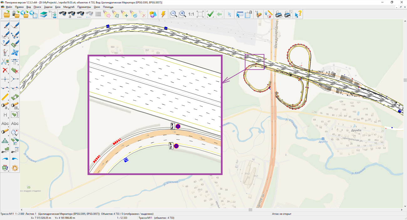
In KB "Panorama" the classifier and library of conventional symbols of the digital large-scale navigation plan were developed. Digital large-scale navigation plan (LSNP) is a digital thematic map containing information about spatial objects sufficient for solving the problem of automated location of a vehicle on the road and calculation of the route of its movement, taking into account the lane traffic, a marking and information of road signs.
Classifier LSNP is made taking into account the requirements: "GOST Р 51256-99. Technical facilities for organizing road traffic. Road marking. Types and basic parameters. General technical requirements"; "GOST Р 52282-2004. Technical facilities for organizing road traffic. Road traffic lights. Types and basic parameters. General technical requirements. Test methods"; "GOST Р 52290-2004. Technical facilities for organizing road traffic. Road signs. General technical requirements".
LSNP is created on the basis of high-precision satellite geodetic measurements corresponding to the accuracy of digital topographic plans of scale 1: 500. Unlike digital navigation maps and digital city plans, where the road is represented by a linear object, on LSNP the road is represented by a set of polygonal, linear and point objects, characterizing all its arrangement. The use of the road2000.rsc digital classifier ensures the automatic loading of data from mobile laboratories intended for collecting data on the state of highways and adjacent objects. Loading is provided by tools of the .
The downloaded information is published as a web-service - digital road model (DRM). The service provides information to external information systems under the unified protocols OGC WMS and WFS. Structure of the DRM web-service includes: digital cartographic substrate, road objects, roadside infrastructure and services, high-precision navigation information presented by the road graph, conditions and traffic modes. is used to publish the DRM on the Internet.
The classifier and the documentation to it are available on the site in the Classifiers section.


KB "Panorama" prepared the training-demonstration example for creation of the user applications for the in the Microsoft Visual Studio environment. This example will help developers learn how to apply the functions and methods of the PANAPI and MAPAPI interfaces to create new program modes.
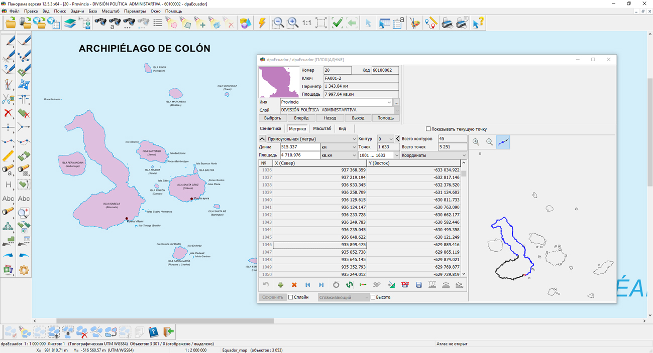
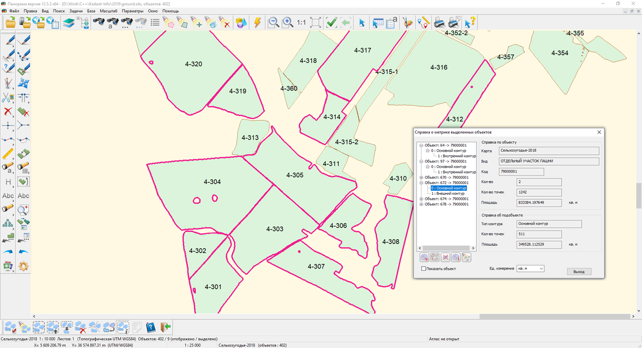
In the example, the task "Processing of multipolygons" is presented. It allows users of GIS "Panorama" to create and edit multipolygons - areal objects, consisting of several external and internal subobjects. Objects of this type are useful at creating maps, when you plan to connect to the maps of external databases. So on the political-administrative map with the help of multipolygons it is convenient to represent the territory of the administrative unit, which includes several separated parts. For example, if the administrative unit includes the territory of several islands. On a map of agricultural land with the help of multi-polygons, individual sites can be combined into one field, which is linked with recording an external database containing information on the crop grown on this field, grade, seed material and other.
To add an application task into the GIS "Panorama", you need to copy the files from the maptask directory to the folder with the system files. Then start the program and select "Toos" -> "Run applications" in the main menu. In the opened dialog with the list of application tasks, select "Add application", specify the application's name and then select the file multipoligon.dll.
The training sample with source codes in C++ language is available for download in the Download section. In the near future, it is planned to prepare training materials with step-by-step explanations of the project's program code.


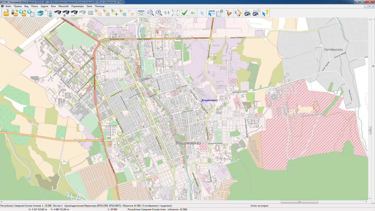
On the geoportal the maps of the Republics of Dagestan and North Ossetia-Alania formed according to OpenStreetMap data, were updated. Source data obtained from the website are complemented by objects from maps of scale 1: 1 000 000. There are added the objects of hydrography, vegetation, road network. For work with the received maps it is possible to use the program of or other software products of KB "Panorama".
Publishing of updates in bank of spatial data is made by using the program of . Publishing contents of bank of spatial data on the geoportal and data access for downloading are implemented by means of GIS WebServer SE.
Free maps on the basis of OpenStreetMap data are available for download on the page "Digital maps and images".


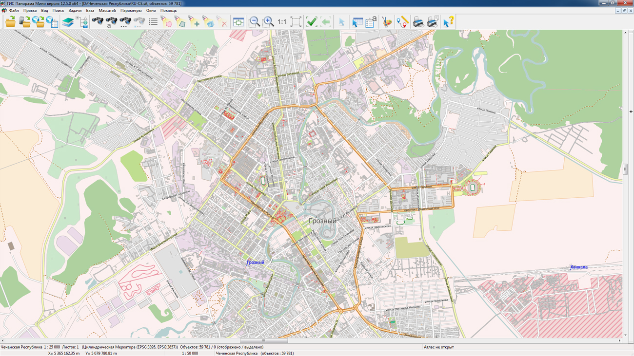
On the geoportal the maps of the Chechen Republic and the Republic of Ingushetia formed according to OpenStreetMap data, were updated. Source data obtained from the website are complemented by objects from maps of scale 1: 1 000 000. There are added the objects of hydrography, vegetation, road network. For work with the received maps it is possible to use the program of GIS Panorama Mini or other software products of KB "Panorama".
Publishing of updates in bank of spatial data is made by using the program of Databank of digital maps and remote sensing data. Publishing contents of bank of spatial data on the geoportal and data access for downloading are implemented by means of GIS WebServer SE.
Free maps on the basis of OpenStreetMap data are available for download on the page "Digital maps and images".


version 3.8 is developed in KB "Panorama". The new version of the program provides tools of user's authentication on the service. Using the authentication of service users, you can receive data in accordance with the access rights set on it. This provides additional security for data exchange with the service, protects resources from unauthorized access.
The mechanism for working with virtual folders has been updated - obtaining information about virtual folders is performed in JSON format to increase processing speed. Map scaling is accelerated, map animation at scaling by buttons is added. The administration module is updated.
The web applications development tool the GIS WebToolKit SE has been refined, which extends the capabilities of GIS WebServer SE and can be integrated into other information systems. Access to data (images, vector maps and terrain information) is provided by Web services using common OGC protocols and ISO standards. Service of GIS WebService SE (OGC WMS/WMTS) provides spatial information in the form of graphic images. As digital model of a relief the various kinds of high-altitude data are used: matrixes (in formats SRTM, GeoTIFF, IMG, MTW), TIN-models, a cloud of points and others. At request there is carried out the automatic sample of the most accurate data onto the specified terrain area with a given resolution. To transfer data of the digital terrain model to the Web, the WCS protocol is used. The relief data are represented as tiles and are cached on the client.
As a source of spatial data, the can be. It provides the collection, storage, search and delivery of spatial data in exchange formats, a displaying the state of the data bank in the form of maps-schemes, the automated formation and updating of geo-covers.
GIS WebServer SE is used in the construction of closed corporate systems to ensure the protection of data having a security classification or a trade secret. GIS WebServer SE is certified for Level 2 of absence of undeclared capabilities. The new version of the program expands the application's capabilities in solving problems of analysis, management and long-term planning of the territories development. GIS WebServer SE is implemented using the toolkit of GIS WebToolKit SE, which can be used in development tools that use the JavaScript.
The new version of the program is available on the website in the section.


Ph.: +7 (495) 739-0245, +7 (925) 221-1603
www.gisinfo.ru | panorama@gisinfo.ru
105005, Russia, Moscow, Baumanskaya Street 7, building 1, office 229 (m. Baumanskaya)
Copyright © Panorama Group 1991 - 2024


 Mobile version
 Full version