Copyright © Panorama Group 1991 - 2024

In KB "Panorama" the of version 12.5.2 is developed. The new version is adapted for work in the development environments of Embarcadero RAD Studio, Delphi and C++ Builder version 10.2 Tokyo. The installation of the GIS ToolKit 12 tools is also possible into Starter releases of the mentioned development environments. Embarcadero company provides the ability to download Delphi Starter and C++ Builder Starter and their free use under certain conditions. These conditions, in particular, include limiting the number of team developers - no more than 5 people, as well as not exceeding the income from the use of Starter products over $ 1000. For more information on the terms of the free use of development environments the Delphi Starter and C++ Builder Starter of version 10.2 Tokyo, please visit the Embarcadero website. The order of installation and use of GIS ToolKit 12 into the development environment of the Starter Edition line is exactly the same as in the case of Delphi and C++ Builder full versions for commercial use.
GIS ToolKit is a toolkit of developer of the geoinformation systems, allowing to process spatial databases. The toolkit consists of a set of visual components (supplied in the source code) and API functions for direct access to the geodatabase. The geo-database can be located either in the workplace (direct access to data) or in the local network or the Internet (using the components of access to the or data exchange over the international protocols WMS, WFS, WCS, WMTS).
The new version of the program is available for download on the page.


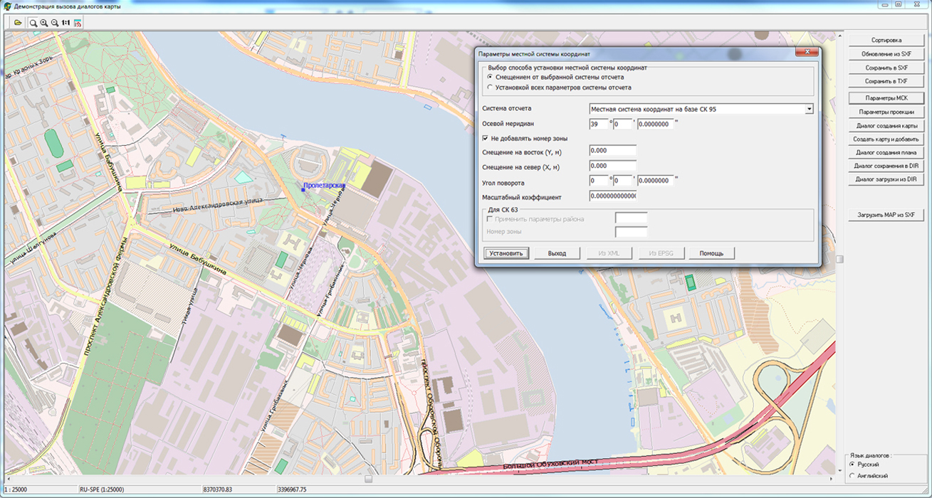

In KB "Panorama" the version 7.4 is developed. In the new version the tools for publication of the information from the spatial databases operated by DBMS Oracle, PostgreSQL, MS SQL and others are refined. Possibility is added to set conventional symbols of database objects by the alphanumeric code stored in a separate field of the database table. The alphanumeric code is an analog of the classification integer code and is also used to encode conventional symbols of objects. In the Classifier Editor of the GIS "Panorama" the possibility is available to enter not only digital codes, but also arbitrary strings in national languages (alphanumeric code). Its main destination is the specifying a mutual conformity of conventional symbols of objects on digital maps and combinations of values of objects attributes, including a code, in databases and other sources of the information. When connecting to a database, the GIS Server has the ability to define a coordinate system in which the spatial description of objects in the database is stored. If the coordinate system and projection parameters specified by the application's settings for displaying the cartographic representation coincide with the parameters of storing of spatial data in the database, the GIS Server does not perform additional operations for transformation of coordinates. If the parameters of the projection and the coordinate system for storing of spatial data in the database differ from the established parameters for cartographical representation of this data on the GIS Server, the transformation of the spatial description of the objects in the database is performed by the DBMS tools directly into the coordinate system of the cartographic representation. Previously, such recalculations were carried out in two stages: at first, the coordinates were converted from the original system to WGS84, and then from WGS84 to the target coordinate system. The coordinate system and projection parameters for both information in the database and for its cartographic representation on the GIS Server are determined by the EPSG code. Such approach accelerates the publication of spatial databases of great volumes.
The new version of the program is available for download on the page.


On the geoportal , maps of the Kaliningrad and Murmansk regions, formed according to OpenStreetMap data, were updated. Source data obtained from the GIS-Lab website are complemented by objects from maps of scale 1: 1 000 000. There are added the objects of hydrography, vegetation, road network. For work with the received maps it is possible to use the program of or other software products of KB "Panorama".
Publishing of updates in bank of spatial data is made by using the program of . Publishing contents of bank of spatial data on the geoportal and data access for downloading are implemented by means of .
Free maps on the basis of OpenStreetMap data are available for download on the page "Digital maps and images".


In the period from 26 to 28 September 2017, Berlin hosted the . The participants of the exhibition demonstrated modern developments and innovative technologies in the field of geoinformatics, photogrammetry, geology, geoengineering and other areas.
Specialists of KB "Panorama" presented software solutions at the exhibition, allowing to perform a full cycle of works on processing and publication of spatial data. Participants of the event showed great interest in software products: with applied tasks, , , and others.
The stand of our company was very popular among representatives of different countries: China, India, Germany, Great Britain, Kazakhstan, Russia, Egypt, Azerbaijan and others. The greatest interest in the use of spatial data in the software solutions of KB "Panorama" was caused by such directions as processing and analysis of a large amount of data, application of service-oriented technologies, creation of vector maps by orthophotomaps and satellite images, generalization of data, monitoring of data and mobile objects, web-technologies in GIS.
It was pleasant to see a considerable quantity of professional visitors from Russia. For example, for a delegation from JSC "SUEK" our company was able to offer software solutions for the tasks of mapping open coal mines using UAVs. The topic of using UAVs of various classes for the creation of aerial photography was at the exhibition of one of the dominant topic by a variety of models of aircraft and the variants of their application.


On the geoportal , maps of the Arkhangelsk and Vologda regions, formed according to OpenStreetMap data, were updated. Source data obtained from the GIS-Lab website are complemented by objects from maps of scale 1: 1 000 000. There are added the objects of hydrography, vegetation, road network. For work with the received maps it is possible to use the program of or other software products of KB "Panorama".
Publishing of updates in bank of spatial data is made by using the program of . Publishing contents of bank of spatial data on the geoportal and data access for downloading are implemented by means of .
Free maps on the basis of OpenStreetMap data are available for download on the page "Digital maps and images".


Ph.: +7 (495) 739-0245, +7 (925) 221-1603
www.gisinfo.ru | panorama@gisinfo.ru
105005, Russia, Moscow, Baumanskaya Street 7, building 1, office 229 (m. Baumanskaya)
Copyright © Panorama Group 1991 - 2024


 Mobile version
 Full version