Copyright © Panorama Group 1991 - 2024

KB "Panorama"'s GIS Constructor for Scientific Linux operation system is updated to version 11.10.3. New version includes extension for means of displaying symbols of aeronautical charts and operational situation maps, that, according to document Doc 8697 ICAO, allows to display the following types of maps : Route map, Map of the area, Map of standard instruments departure (SID), Map of standard instruments arrival (STAR), Map of instrument landing system (ILS), Map of visual approach, Airfield's map with table of weather minima, Map of ground airfield movement and parking places,
Map of area of a final approach stage, Class "A" map of ICAOobstacles, Class "B" map of ICAO obstacles
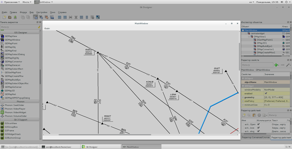
GIS Constructor is a set of components for use in a visual programming environment Qt Designer that allows developing GIS applications. Visualization of the contents of the digital maps is produced by the conventional symbols accepted for topographical, geographical review, cadastral and other map types. Geographic Information System provides user wide opportunities in creation (addition) custom symbols, with support a variety of coordinate systems and projections.
The new version of the program is available for download in the section.


In KB "Panorama" the version 2.4 is developed. In the new version the tree of layers, available to the user, is formed automatically taking into account the composition of geodata (vector maps, images, matrixes of heights), available in virtual folders. Composition of data in virtual folders can be changed at execution of various computational and analytical requests. The user can forcedly update a tree of data layers. This makes it possible to change the composition of available layers in accordance with the status of data in the virtual folders.
The list of available layers is formed from both the virtual folders of service the SE and virtual folders of . Access to the data is performed taking into account the rights of the user onto a virtual folder. Options for publishing the virtual folder are configured in the administration module. Publication of map layers through the mechanism of virtual folders facilitates administration of a large number of data, the composition of which varies with time.
The mode "Creation of thematic layer" is updated. Possibility is added to create thematic maps by characteristics of all objects of the map layer. For thematic maps there are added an output of the map legend and possibility of change of a transparency of picture.
User's interface is advanced. There is added the possibility to set units of area and length at displaying the information on objects of a map and execution of calculations on a map. Work of the mode "Search by semantics" is optimized at a large number of objects types of a map layer. In the administration module the mechanism of forming a tree of map layers is updated. Access to the data (to images, maps and the information on the terrain) is provided by Web-services according to the conventional protocols of OGC and the ISO standards. Service the GIS WebService SE (OGC WMS/WMTS) provides the spatial information in the form of graphic representations. As digital model of a relief the various kinds of elevation data are used: matrixes (in formats SRTM, GeoTIFF, IMG, MTW), TIN-models, a cloud of points and others. At request there is executed an automatic selection of the most exact data onto the specified portion of the terrain with the specified resolution. For transmission of data of digital model of a relief in Web the WCS protocol is used. Data of relief are presented in the form of tiles and are cached.
GIS WebServer SE can be used at construction of private corporate systems for ensuring protection of data having a security classification or a trade secret. GIS WebServer SE is certified by 2-nd level of undeclared capabilities absence. The new version of the program expands the application's possibilities in solving problems of analysis, management and long-term planning of territories development. GIS WebServer SE is implemented with use of toolkit the GIS WebToolKit SE which can be applied in the development tools that use the JavaScript.
The new version of the program, documentation and presentation are available on the web-site in section.


Geoportal updated the maps of Tula and Yaroslavl regions formed according to OpenStreetMap data. Source data obtained from the website are complemented by objects from maps of scale 1: 1 000 000. There are added the objects of hydrography, vegetation, road network. For work with the received map it is possible to use the program of or other software products of KB "Panorama".
Publishing of updates in bank of spatial data is made by using the program of . Publishing contents of bank of spatial data on the geoportal and data access for downloading are implemented by means of .
Free maps on the basis of OpenStreetMap data are available for download on the page "Digital maps and images".

In KB "Panorama" the x64 version 6.5.0 is developed for Astra Linux SE operating system. In the new version the support of command is added for construction of geo-coverings from the data sets stored in the . It allows the operator of the Databank to select records by various criteria (territory, date of terrain shooting, scale, type of a material and others) and to form coverings from vector maps, rasters or matrixes onto the specified territory in the chosen coordinate system.
Coverings are placed into the specified virtual folders on the GIS Server that provides automatic access to them of various groups of users without additional administration. For convenience of conducting versions of geo-coverings at creation of geo-covering in the specified virtual folder there are automatically created the subdirectory with a name of a formed geo-covering (the operator specifies), and in it a subdirectory with current date (YYYYMMDD) GMT. Configuring of virtual folders for placing geo-coverings is carried out by the Administrator of Databank of Digital Maps and Remote Sensing Data for each group of the data.
Coordinate system of a covering can be specified by EPSG code (for example, "epsg:3857"). For formation of geo-coverings in the user's coordinate system the record of type "crslist:USER_CODE" is supported. In this case the coordinate system parameters are read on the GIS Server from the crslist.xml file by the specified code (identifier) of user's coordinate system. Records into the crslist.xml file can be added from the task "Map Passport" in the .
GIS Server provides remote access to vector maps, remote sensing data, matrices, documents and databases of spatial data. There is supported a multilevel connection of GIS Servers among themselves for the distributed storage and processing of spatial data with automatic replication, backup and data protection.
GIS Server SE certified by Level 2 of absence of undeclared possibilities in system of certifying securities of information of the Ministry of Defence of the Russian Federation.
The new version of the program is available for download in the section.


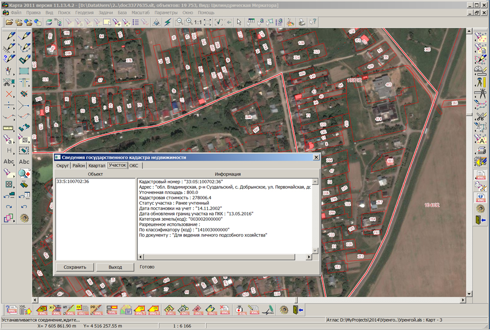
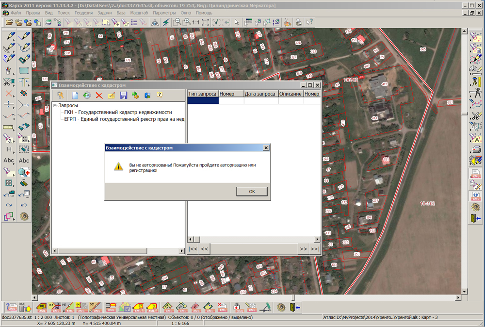
In KB "Panorama" the version 11.13.4.3 is developed. In the new version of the program the dialog the "Information from the State Real Estate Cadastre" is adapted for information interaction with the updated resource "Public cadastral map" ().
There is implemented the new mode "Requests into real estate cadastre", providing obtaining of real property information by formation of requests into the State Real Estate Cadastre (SREC) and into the Unified State Register of rights to immovable property and transactions with it (EGRP). Results of execution of requests into SREC are the cadastral extract of the ground area, cadastral passport, cadastral plan of territory and information on cadastral cost of the ground area. The result of performing the request into the Unified State Register are an extract of the rights to the property and an extract of the transfer of the property's rights. The received XML-files can be loaded into system by means of the mode "Download cadastral data from XML-file."
Updated dialogue supports the reading of data by KVOKS_v03 scheme "Cadastral extract about a building, a construction, an object under construction (Cadastral extract on the conditional part of the linear construction)". In modes the "Technical plan of a construction" and the "Technical plan of object under construction" there is added a processing of objects at formation of the test report and XML-file. Dialog "Creation of objects (Import from CSV file)" is improved. There are added the elements to control structure of information line (a point name, X coordinate, Y coordinate, H coordinate) and field separator.
The new version of the program is available on the section.

Ph.: +7 (495) 739-0245, +7 (925) 221-1603
www.gisinfo.ru | panorama@gisinfo.ru
105005, Russia, Moscow, Baumanskaya Street 7, building 1, office 229 (m. Baumanskaya)
Copyright © Panorama Group 1991 - 2024


 Mobile version
 Full version