Copyright © Panorama Group 1991 - 2024

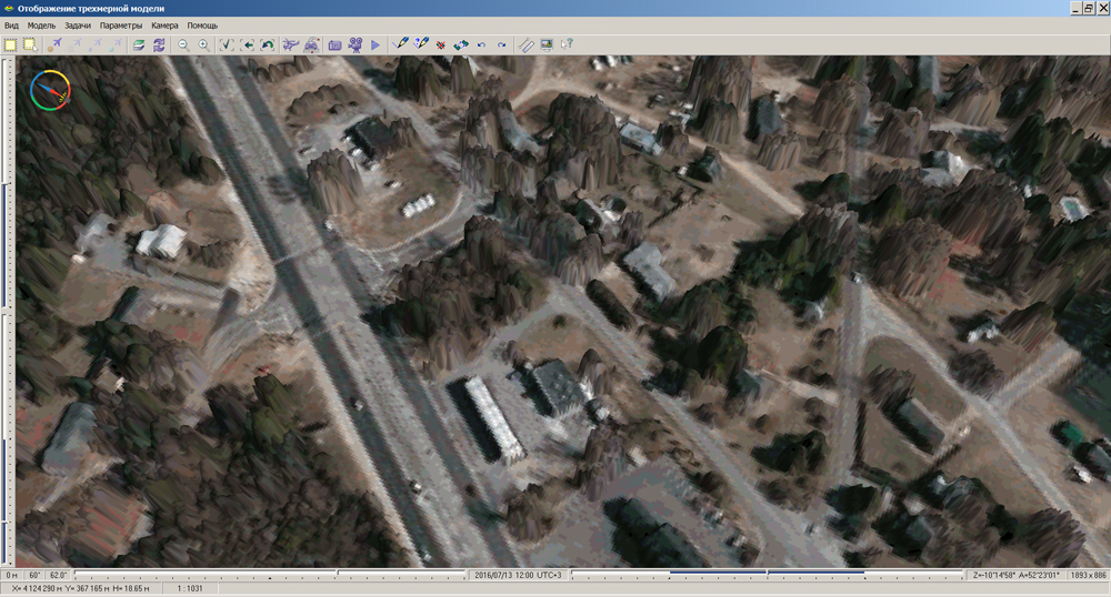
In KB "Panorama" the Desktop x64 version 12.2 is developed. In the new version in the task the "Navigator 3D" there is developed a constructing the 3D-model of relief and surface objects by a cloud of points.
Cloud of point is the result of laser scanning of terrain, obtained by laser radar LIDAR (LIght Detection And Ranging). GIS "Panorama" allows to carry out loading of a cloud of points from open exchange formats: binary format LAS and the textual format TXT containing array of points in the form of records XYHC (planned point coordinates, height and a code). Preliminary visual estimation of points cloud is performed in a two-dimensional view mode. More demonstrably the cloud of points can be shown as a three-dimensional model with use of orthophotomap, photo- image of terrain from a geoportal, or the image tied to the terrain.
The program allows to carry out construction of two types of models (solid and nodal). Construction of solid model is recommended for demonstration of regular models of a relief (matrixes of elevations) and the cloud of points containing mainly points of the terrain relief. Construction of nodal model is recommended for demonstration of a cloud of the points containing points of the terrain relief, buildings, vegetation and other terrain objects. Interface of the task "3D Navigator" allows to carry out a filtration of interference, obtained by the terrain scanning. The rough filtration deletes points of individual hindrances, the exact filtration deletes points of the individual and linear hindrances caused by objects such as power lines.
In application the "Database" the mode is added, allowing to create reports in OpenOffice format. Unloading into the report is made with using the tools of spreadsheet OpenOffice Calc which is a part of the OpenOffice.org suite. The mode "Update of semantics" is extended. Possibility of updating of semantics of object by the key value is added (for semantics type - Code from the classifier (list)), saving and restoration of user settings is implemented.
Into the main panel there are added the modes "Distances measurement (construction of orthodrome)", "Mark by polygon", "Mark inside object", "Mark by any area". The new mode "Mark by any area" allows to map an area of any form. Objects are selected according to the options specified in the mode "Parameters of selection".
Into the "Map Legend" dialog the "Model" bookmark is added intended for displaying and editing parameters of irregular models of a surface - TIN-models (model of terrain) and MTD-models (a cloud of points).
Into the file with the description of parameters of local coordinate systems "LCS of the Russian Federation Subjects" there are added the parameters onto each zone of local coordinate system.
The list of units of measure is expanded at displaying distances and heights. There is added a choice of heights in feet and distances in nautical miles. Into dialog of building a profile of heights there are added the units of length measure - kilometers, nautical miles and the height measurement units - ft. Into dialog "Calculator" there are added the units of measure - inches, ft, yards.
In the task of Opening the data from the there is implemented the possibility of updating the the on the basis of data sets which are included into the current open document. A set of data for update can contain maps, rasters, matrixes. Vector maps before loading are converted into SXF format.
The new version of the program is available for download in the section.


Geoportal updated the maps of Smolensk and Tver regions formed according to OpenStreetMap data. Source data obtained from the website are complemented by objects from maps of scale 1: 1 000 000. There are added the objects of hydrography, vegetation, road network. For work with the received map it is possible to use the program of or other software products of KB "Panorama".
Publishing of updates in bank of spatial data is made by using the program of . Publishing contents of bank of spatial data on the geoportal and data access for downloading are implemented by means of .
Free maps on the basis of OpenStreetMap data are available for download on the page "Digital maps and images".

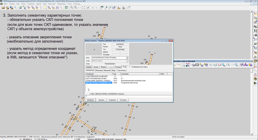
The specialists of KB "Panorama" have developed training videos on the formation of cadastral documents in XML format. In video lessons the order of using the is shown at loading the initial data, preparation of a map and formation of output documents in electronic form. The video lesson contains information about the full cycle of preparation of this cadastral document, including the preparation of the map (plan) of object of land management. The video lesson is devoted to the peculiarities of preparation of cadastral map and land survey plan formation in electronic form.
Video describes the steps to load the XML-extracts from the body of State Realty Cadastre. There are in detail considered the questions of creating a cadastral map in local coordinate system for the further processing the results of cadastral measurements. There is shown the process of preparation and registration of a cadastral map taking into account a variant of execution of cadastral works. There are shown the steps in the "Map Editor" to create the new cadastral objects and design elements. The operations procedure is considered at entering the initial data on object of cadastral works and editing the attributive data of cadastral objects. It describes how to attach documents to XML-file. It shows the sequence of steps for the formation of the XML-file, digital signatures and ZIP-package to be sent into the body of cadastral registration.
You can find teaching materials on the Video lessons page.


In KB Panorama of version 2.4 is developed is developed for Astra Linux Special Edition operating system. In the new version the mode of creation of geo-coverings from stored data sets is implemented. The mode allows to select data sets by various criteria (territory, date of terrain shooting, scale, type of a material and others) and to form coverings from vector maps, rasters or matrixes in the chosen coordinate system. Procedure of forming a geo-covering is carried out on the GIS Server by the command of the Databank operator. For placing the created geo-coverings the virtual folders of are used.
It provides automatic access to them without additional administration of various groups of users. For convenience of conducting versions of geo-coverings in the specified virtual folder the separate folders for each covering automatically are created.
Configuring of virtual folders for placing geo-coverings is carried out by the Administrator of Databank of Digital Maps and Remote Sensing Data for each group of the data. Coordinate system of a covering can be specified by EPSG code (for example, "epsg:3857") or by a code of the user's coordinate system (for example, crslist:user_code). In this case the coordinate system parameters are read on the server from the service file by the specified code of user's coordinate system (identifier). Parameters of the user's coordinate system can be added onto the GIS Server from the task "Map Passport" of system the . Upon termination of procedure of forming the geo-covering the work protocol is created. Data sets of geo-coverings are recorded in database of metadata and displayed on a map-scheme. Objects of geo-coverings of different groups of the data have different color filling on the scheme. During formation of geo-coverings the survey image also is created.
Databank of digital maps and remote sensing data is intended for gathering, storage, search, issuance of spatial data in exchange formats and displaying the status of a databank in the form of maps-schemes. Maps-schemes are conducted for each type of stored data: vector maps, remote sensing data, matrixes of elevations and terrain models. The reference to the Databank and data exchange is carried out via the web-interface. The program can work in operating systems with the closed contour where processing of the protected data is carried out. The databank includes applications the GIS Server and GIS WebService SE that are certified by Level 2 of absence of undeclared possibilities in system of certifying securities of information of the Ministry of Defence of the Russian Federation. For conducting the base of metadata there are used the DBMS PostgreSQL (OS Astra Linux SE), DBMS Zarya (OS Zarya Data Processing Center).
The module of administration of the Databank of Digital Maps and Remote Sensing Data is included into the Complex. It provides customizing the general parameters of the application's work, a customizing the parameters of metadata database, a choosing the formats of storage and the composition of groups of stored files, views of objects for maps-schemes, a conducting the groups of users and appointment of the users rights onto access to the data and allowed actions. Users of desktop programs of GIS "Panorama", and others can connect to the Bank of metadata via the GIS Server.
Source codes of modules of loading the sets of spatial data and metadata into the Databank of Digital Maps and Remote Sensing Data are included into SDK for the GIS Server and GIS WebService SE. Using SDK it is possible to expand operations on conducting archive of spatial data from other applications.
New versions of software and documentation are available on the page.

In KB "Panorama" the software package the Panorama AGRO Service of version 2.0 is developed. The new version takes the data from the monitoring's objects operating in different time zones. Panorama AGRO Service program is designed to solve the tasks: synchronisation of lists of monitoring's objects, equipped with telematic terminals GLONASS/GPS, between databases of operators of monitoring's satellite systems and database the ; relaying of the navigation data and indications of various sensors from services of operators of satellite navigation systems of monitoring the motor transport and the special technics into the database.
Service carries out transfer of data from following telematic platforms: AutoGraph, ENDS, Stabliner, GLOSAV, Wialon, Gelix-2. It provides possibility of obtaining the navigation information more than from eight hundreds various types of devices. Use of Panorama AGRO Service allows to refuse a rigid binding to the type of onboard kit and provides scaling of system at the expense of independent connection to it by producers of one's own objects of monitoring. Requirements to objects of monitoring are available to the public and include the description of supported sensors types, the protocol of information interaction and the registration regulations in the hardware system.
The new version of the program and documentation are available for download on the Download page.


Ph.: +7 (495) 739-0245, +7 (925) 221-1603
www.gisinfo.ru | panorama@gisinfo.ru
105005, Russia, Moscow, Baumanskaya Street 7, building 1, office 229 (m. Baumanskaya)
Copyright © Panorama Group 1991 - 2024


 Mobile version
 Full version